

Mori Atlas logo
National parkHumboldt National Park

Discover the mapped boundaries and ecological significance of this vital Australian national park.

Humboldt National Park: Queensland's Protected Wetland Landscape in the Brigalow Belt

Humboldt National Park represents a key protected wetland within Queensland's Brigalow Belt bioregion, covering 76.60 square kilometers southeast of Emerald. Established in 2009, this national park safeguards a crucial freshwater ecosystem in a landscape heavily influenced by agricultural development. The park's mapped geography within the Comet River catchment offers a vital refuge for biodiversity, showcasing the unique subtropical wilderness that once characterized this Australian region.

WetlandsBrigalow BeltQueenslandBirdwatchingProtected AreaIUCN Category II

Humboldt National Park

National park

Park overview

Structured park overview, official facts, and landscape profile for Humboldt National Park

Humboldt National Park park facts, protected area profile, and essential visitor context

Review the core facts for Humboldt National Park, including designation, size, terrain, visitor scale, habitats, and operating context in one park-focused overview.

About Humboldt National Park

Humboldt National Park occupies a distinctive position among Queensland's protected areas as a wetland sanctuary within the Brigalow Belt, a biogeographic region that spans central Queensland from near the coast to inland areas. The park's establishment in 2009 reflected a growing recognition of the ecological value of remaining wetlands in this heavily modified landscape. The Brigalow Belt was historically characterized by brigalow acacia woodland, open grasslands, and various wetland systems, but extensive clearing for grazing and cropping has reduced the region's natural cover dramatically. Within this context, Humboldt National Park preserves a representative example of the wetland ecosystems that once dotted the landscape, maintaining ecological connectivity and providing sanctuary for species that depend on waterlogged habitats. The park's position within the Comet River water catchment ties it to broader hydrological systems that shape the region's ecology.

Quick facts and research context for Humboldt National Park

Humboldt National Park is located in Queensland, Australia, near the town of Rolleston. The park was established in 2009 and covers 76.60 square kilometers. It is classified as an IUCN Category II protected area, managed by the Queensland Parks and Wildlife Service. The park protects wetland ecosystems within the Comet River catchment in the Brigalow Belt bioregion. The area supports 148 animal species and 278 plant species, making it a biodiversity hotspot within a region that has undergone substantial land-use change.

Protection and recognition

Analyzing documented terrestrial protection scope and global conservation designations

Humboldt National Park Protected Area Designation and Official Protection Status

Researchers can verify the official terrestrial protection scope and documented designation history for Humboldt National Park. Reliable data profiles provide essential geographic context by mapping established conservation boundaries against international registry databases.

Protection details

Protection scope
Terrestrial
Transboundary protection
No
Park context

Deeper park guide and search-rich context for Humboldt National Park

Humboldt National Park history, landscape, wildlife, and travel context

Explore Humboldt National Park through its history, landscape character, ecosystems, wildlife, conservation priorities, cultural context, and seasonal travel timing in a structured park guide built for atlas discovery and search intent.

Why Humboldt National Park stands out

Humboldt National Park is best known for its wetland protection within the Brigalow Belt bioregion, a landscape that has been largely converted to agricultural use. The park preserves one of the remaining significant wetland systems in this bioregion, providing critical habitat for both fauna and flora in a region where such habitats have become increasingly rare. TheComet River catchment wetlands offer a glimpse of the original ecological character of this part of central Queensland, serving as refuge for species adapted to periodically inundated environments.

Humboldt National Park history and protected-area timeline

Humboldt National Park was established in 2009 as part of Queensland's ongoing efforts to expand its protected area network. The park was created to safeguard wetland habitats within the Brigalow Belt bioregion, an area that had experienced significant land clearing and modification. The Queensland Parks and Wildlife Service assumed management responsibility for the park, implementing protection measures for the wetland ecosystems and the biodiversity they support. The relatively recent establishment of the park reflects contemporary conservation priorities that recognize the importance of protecting remaining wetland systems in agricultural landscapes, where such habitats have become scarce and fragmented.

Humboldt National Park landscape and geographic character

The landscape of Humboldt National Park centers on wetland environments within the Comet River catchment. The Brigalow Belt bioregion features a mix of flat to gently undulating terrain with scattered elevation changes. The wetlands within the park consist of seasonally inundated areas, permanent water bodies, and surrounding terrestrial environments that transition from wet to drier conditions. The vegetation surrounding the wetlands includes remnants of the original brigalow woodland that once dominated the region, though much of the surrounding landscape has been cleared for agricultural purposes. This contrast between the protected wetland interior and the modified agricultural matrix surrounding the park boundary defines much of the park's visual character.

Humboldt National Park ecosystems, habitats, and plant life

The nature of Humboldt National Park is defined by its wetland ecosystems within the Brigalow Belt bioregion. The park supports a remarkable diversity of plant life with 278 species recorded within its boundaries, reflecting the varied habitats from open water through reed beds to woodland margins. The wetland environments provide critical ecological functions including water filtration, flood regulation, and carbon storage. The Brigalow Belt's subtropical climate supports a mix of species with both tropical and temperate affinities, and the protected wetlands serve as biodiversity reservoirs in a landscape where native vegetation has been extensively cleared. The park's habitats range from permanent water bodies to seasonal wetlands that fill and dry in response to rainfall patterns.

Humboldt National Park wildlife and species highlights

Humboldt National Park provides habitat for 148 animal species, making it an important refuge for wildlife in the Brigalow Belt region. The wetland environments support diverse fauna including waterbirds, amphibians, reptiles, and mammals adapted to moist habitats. The park's position within the Comet River catchment creates ecological connectivity to broader river systems, allowing species to move between habitats and maintaining genetic exchange between populations. The contrast between the protected wetland core and the surrounding agricultural landscape means the park serves as a critical refuge for species that cannot survive in modified environments, functioning as an island of natural habitat in a largely cleared landscape.

Humboldt National Park conservation status and protection priorities

Humboldt National Park represents important conservation outcomes for Queensland's Brigalow Belt bioregion, one of Australia's most heavily modified landscapes. By protecting remaining wetland habitats, the park contributes to the survival of species and ecological communities that would otherwise be vulnerable to ongoing habitat loss. The park's designation as an IUCN Category II protected area reflects its primary objective of preserving natural ecosystems. The Brigalow Belt has been identified as a region requiring targeted conservation attention due to the extent of clearing and the remaining ecological values in areas that have escaped development. Humboldt contributes to the portfolio of protected areas that collectively maintain biodiversity in this altered landscape.

Top sights and standout views in Humboldt National Park

The standout feature of Humboldt National Park is its role as a protected wetland in the Brigalow Belt, a bioregion where wetlands have become rare due to extensive agricultural development. The park protects 278 plant species and 148 animal species within its 76.60 square kilometers, demonstrating significant biodiversity relative to its area. The Comet River catchment wetlands represent ecological heritage from Queensland's pre-colonial landscape, offering insight into the original character of this region's ecosystems. For visitors, the park provides opportunities to experience wetland environments that are otherwise absent from the surrounding agricultural landscape.

Best time to visit Humboldt National Park

The best time to visit Humboldt National Park depends on seasonal conditions that affect wetland appearance and wildlife activity. Queensland's subtropical climate brings wet conditions during summer months, typically from November through March, when wetlands may be fuller and waterbird activity increases. The dry season from April through October generally offers more accessible conditions and clearer viewing opportunities, though some wetlands may be reduced. Wildlife viewing can be productive year-round, though the cooler dry season months often see increased activity as animals congregate around remaining water sources.
Monthly climate preview

Long-term representative measurements track monthly temperature ranges and precipitation patterns across Humboldt National Park

Humboldt National Park Climate Normals, Annual Temperature and Precipitation Rhythm

Representative coordinates record measured monthly averages spanning from cooler midyear lows to warmer summer peaks alongside consistent low precipitation rates. Examining the full twelve-month profile provides detailed meteorological baseline data for understanding regional environmental conditions.
Annual mean22 °C
15 °C28 °C
Jan28°
Feb27°
Mar26°
Apr22°
May19°
Jun16°
Jul15°
Aug17°
Sep21°
Oct24°
Nov26°
Dec27°
Warmest month
January

27.7 °C

Coolest month
July

14.9 °C

Wettest month
February

3.7 mm/day

Driest month
July

0.6 mm/day

Park location guide

Geography guide, regional context, and park location map for Humboldt National Park

Humboldt National Park park geography, regions, and map view in Australia

Understand where Humboldt National Park sits in Australia through a broader geographic reading of the surrounding landscape, nearby location context, and its mapped position within the national park landscape.

How Humboldt National Park fits into Australia

Australia is a constitutional monarchy and federal parliamentary democracy comprising six states and ten territories. With a population of nearly 28 million, it is one of the world's most urbanised countries, with most people concentrated on the eastern seaboard. The country has a high Human Development Index and is known for its cultural diversity, ancient Aboriginal heritage, and unique wildlife.

Wider geography shaping Humboldt National Park in Australia

Australia occupies the entire Australian continent, the island of Tasmania, and numerous smaller islands. It is the world's flattest and driest inhabited continent, featuring vast deserts in the interior (the Outback), tropical rainforests along the eastern coast, and a coastline bordering the Indian and Pacific Oceans.

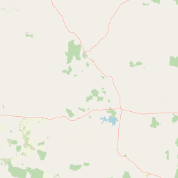
Map view of Humboldt National Park

Use this park location map to pinpoint Humboldt National Park in Australia, understand its exact geographic position, and read its mapped placement within the surrounding landscape more clearly.

Pigeon | © OpenStreetMap contributors

Location context for Humboldt National Park

Queensland
Park atlas

Trace the regional spread of protected wetlands and diverse conservation landscapes across Queensland, comparing unique protected areas.

Discover More Protected Areas Near Humboldt National Park and Explore Queensland's Wetland Geography

Explore a curated selection of national parks and protected areas located geographically near Humboldt National Park, encompassing Queensland's significant Brigalow Belt bioregion. This focused collection enables direct comparison of wetland environments and surrounding agricultural landscapes, providing valuable atlas context for the region's conservation efforts.
National parkQueensland
About 34 km away#1 closest

North

Blackdown Tableland National Park: National Park Protected Landscape Discovery

Explore mapped terrain and regional geography in Queensland.

Blackdown Tableland National Park offers a distinct protected landscape for geographic exploration within Queensland, Australia. As a designated national park, its mapped boundaries and surrounding natural terrain provide crucial context for understanding regional geography. This entry serves as a vital point for atlas-based discovery, detailing the park's identity and its contribution to the diverse natural landscapes of northeastern Australia.

Area
320 km²
Established
1991
IUCN
II
Relief
Highland
National parkQueensland
About 65 km away#2 closest

South

Expedition National Park: A Dramatic Sandstone Mountain Landscape in Central Queensland

Explore protected areas, mapped ridgelines, and Robinson Gorge geography.

Expedition National Park represents a significant protected landscape in Queensland, distinguished by the striking Expedition Range. This mountainous terrain, characterized by rugged sandstone cliffs, deep gorges like Robinson Gorge, and dry eucalyptus forests, offers a unique geographic contrast to the surrounding plains. As a national park, it plays a crucial role in conserving biodiversity within the Brigalow Belt bioregion, providing an essential reference point for understanding regional protected areas and natural terrain.

Area
1,080 km²
Established
1991
IUCN
II
Relief
Mountain
National parkQueensland
About 78 km away#3 closest

North

Taunton National Park: Queensland's Vital National Park and Endangered Species Refuge

Mapped brigalow landscapes and semi-arid woodland terrain.

Taunton National Park in Central Queensland is a protected area of immense conservation value, serving as the last known natural habitat for the endangered bridled nail-tail wallaby. This national park protects representative ecosystems of the Northern Brigalow Belt, featuring distinct brigalow vegetation communities and poplar box woodlands across its cracking clay and texture-contrast soils. Understand the park's geographic setting, its mapped terrain, and the critical role it plays in preserving Australia's unique marsupial populations and diverse flora within the wider regional context.

Area
116 km²
Established
1986
IUCN
II
Relief
Lowland
National parkQueensland
About 84 km away#4 closest

South

Nuga Nuga National Park: Protected Landscape Exploration in Queensland

Mapped terrain and regional park geography.

Gain a structured understanding of Nuga Nuga National Park, a designated national park situated within Queensland. This detailed view focuses on its geographic setting, mapped boundaries, and the natural landscape context it offers for atlas-based exploration. Discover the park's identity as a protected area and its contribution to the regional geography of northeastern Australia.

Area
28.6 km²
Established
1993
IUCN
II
Access
Access unknown
National parkQueensland
About 84 km away#5 closest

Southeast

Palmgrove National Park: Queensland's Remote Protected Landscape for Scientific Conservation

Rugged sandstone terrain and unique eucalypt woodlands define this park.

Palmgrove National Park is a significant scientific reserve in south-central Queensland, Australia, characterized by its dissected sandstone terrain and dry eucalypt woodlands. Designated as a strict nature reserve, its primary value lies in protecting vulnerable species and threatened ecosystems, notably serving as a crucial breeding habitat for the black-breasted buttonquail. The park's isolated geography and limited public access underscore its importance as a sanctuary for avian conservation and ecological research within Australia's protected areas network.

Area
256 km²
Established
1991
IUCN
Ia
Relief
Upland
National parkQueensland
About 90 km away#6 closest

West

Minerva Hills National Park: Queensland National Park Atlas and Mapped Landscape

Explore its protected boundaries and geographic setting in northeastern Australia.

Minerva Hills National Park is a distinct protected area offering valuable insights into Queensland's natural geography. This detail page provides essential context for understanding the park's landscape character, its mapped natural terrain, and its significance as a national park within the northeastern Australian region. Engage with its geography to understand its place in the larger atlas of protected lands.

Area
27.9 km²
Established
1994
IUCN
II
Relief
Mountain
National parkMaranoa Region
About 93 km away#7 closest

Southwest

Carnarvon National Park: Mapped Geography and Protected Landscape Identity

Explore the sandstone gorges and ancient sites of Queensland's natural heritage.

Carnarvon National Park represents a significant protected area within the Maranoa Region of Queensland, Australia. This national park encompasses a vast expanse of approximately 2,980 square kilometers, primarily celebrated for its dramatic sandstone gorges, particularly Carnarvon Gorge, and its globally significant Aboriginal rock art sites. Positioned across the Great Dividing Range, the park's landscape features a compelling mix of deep valleys, sandy plains, and basalt-capped tablelands, offering rich cartographic and geographic context. Its designation as a national park underscores its importance for preserving these unique natural and cultural landscapes for atlas-based discovery.

Area
2,980 km²
Established
1932
IUCN
II
Visitors
65K annual
National parkQueensland
About 127 km away#8 closest

Northeast

Goodedulla National Park: Queensland National Park Atlas and Geographic Exploration

Discover its mapped protected area and landscape context.

Goodedulla National Park is a designated national park in Queensland, Australia, offering a focused entry point for atlas exploration of protected landscapes. Understand its specific geographic scope, mapped boundaries, and how it fits within the natural and regional context of Queensland. This resource is tailored for users interested in the detailed geography and protected-area data of Australia's natural landscapes.

Area
255 km²
Established
1994
IUCN
II
Relief
Lowland

Common questions about visiting, size, designation, and location context for Humboldt National Park

Humboldt National Park FAQs for park facts, access, geography, and protected area context

Find quick answers about Humboldt National Park, including protected-area facts, park geography, trail and visitor context, and how the park fits into its surrounding country and regional landscape.
MoriAtlas Explorer

Continue Your Protected Areas Search Across the Global Atlas

Deepen your exploration by continuing the structured search for national parks and protected areas worldwide. Utilize the comprehensive filtering capabilities to compare different conservation landscapes and refine your understanding of global park geography. Discover more about the distribution and characteristics of protected natural areas.

Global natural geography