Mori Atlas logo
National parkKamuku National Park

Discover the mapped boundaries and natural terrain of a key Nigerian savanna ecosystem.

Kamuku National Park: Nigeria's Protected Savanna Landscape and Inselberg Geography

Kamuku National Park represents a crucial protected savanna ecosystem within Nigeria, offering a unique window into the country's natural heritage. This page details the park's geographic scope, its prominent inselberg formations like Goron Dutse, and its role as a significant habitat for elephants and diverse bird species. Understand the mapped landscape and regional context of this protected area, providing an atlas-quality view of its ecological importance.

National ParkSavanna EcosystemElephant HabitatInselberg LandscapeBirdwatchingGuinea Savanna

Kamuku National Park

National park

Park overview

Structured park overview, official facts, and landscape profile for Kamuku National Park

Kamuku National Park park facts, protected area profile, and essential visitor context

Review the core facts for Kamuku National Park, including designation, size, terrain, visitor scale, habitats, and operating context in one park-focused overview.

About Kamuku National Park

Kamuku National Park represents one of Nigeria's most significant protected savanna ecosystems, located in the western region of Kaduna State. The park's establishment in 1999 marked a milestone in Nigerian conservation, converting the former Native Authority Forest Reserve of Birnin Gwari into a national park following decades of protective management. This transition was influenced by the success of community-based sustainable resource usage projects led by Savanna Conservation Nigeria, demonstrating how local engagement can support conservation outcomes. The park's vast expanse of savanna landscape provides critical habitat for both resident and migratory species, while its geological features create a visually striking environment that distinguishes it from other Nigerian protected areas. The federal government has expressed interest in developing eco-tourism infrastructure in Kamuku and other national parks, though security concerns in the region have temporarily affected park operations in recent years.

Quick facts and research context for Kamuku National Park

Kamuku National Park covers 1,120 square kilometers in western Kaduna State, Nigeria, near the town of Birnin Gwari. The park was upgraded from a state game reserve to a national park in May 1999, following successful community-based conservation initiatives managed by Savanna Conservation Nigeria. The terrain is generally flat with gradual slopes rising toward the Birnin Gwari Ridge along the eastern boundary. The park's vegetation is characterized by Guinea Savanna with dominant tree species including Isoberlinia doka, Terminalia avicennioides, and Detarium macrocarpum, while riparian forests along seasonal rivers feature oil palms. The protected area is adjacent to the Kwiambana Game Reserve to the northwest.

Protection and recognition

Documented terrestrial conservation scope and official global classification data

Kamuku National Park Protection Status and Official Designation Details

Geographers and conservation researchers can examine the official terrestrial status and documented protection framework of Kamuku National Park. Analyzing verified management classifications and legal boundaries offers essential regional context for understanding West African protected landscapes.

Protection details

Protection scope
Terrestrial
Transboundary protection
No
Park context

Deeper park guide and search-rich context for Kamuku National Park

Kamuku National Park history, landscape, wildlife, and travel context

Explore Kamuku National Park through its history, landscape character, ecosystems, wildlife, conservation priorities, cultural context, and seasonal travel timing in a structured park guide built for atlas discovery and search intent.

Why Kamuku National Park stands out

Kamuku National Park is best known for its dramatic inselberg landscape, particularly the striking Goron Dutse, a large isolated granite peak with a visually distinctive smooth surface marked by alternating black and white bands. The park is also renowned for its population of African elephants, which serve as a major attraction for visitors, and for supporting significant populations of roan antelopes, a species that is declining in many other Nigerian protected areas. The park's birdlife is exceptional, with rare species including the secretarybird, Denham's bustard, and Abyssinian ground-hornbill, all of which are difficult to encounter in other parts of Nigeria.
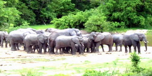
A group of elephants standing on a sandy shore near a body of water with dense green vegetation in the background.
A herd of elephants gathered near a water source in Kamuku National Park.

Kamuku National Park history and protected-area timeline

The conservation history of Kamuku National Park traces back to 1936 when the area was first designated as the Native Authority Forest Reserve of Birnin Gwari under the Northern Nigeria Government. This early designation reflected the region's ecological importance and the colonial administration's recognition of the need to protect remaining forest cover in the savanna zone. The area was subsequently upgraded to a state game reserve, reflecting its growing importance for wildlife conservation. In May 1999, the reserve was elevated to national park status, marking its formal inclusion among Nigeria's premier protected areas. This elevation came after successful community-based conservation initiatives that promoted sustainable resource usage among local populations, demonstrating that collaborative approaches to conservation could yield positive results. The park's location adjacent to the Kwiambana Game Reserve to the northwest creates a larger conservation landscape, though both areas face ongoing challenges from illegal hunting and cattle grazing by pastoralist settlements.

Kamuku National Park landscape and geographic character

The physical landscape of Kamuku National Park is characterized by generally flat terrain that gradually slopes upward toward the Birnin Gwari Ridge along the eastern boundary. The park's most distinctive geological feature is the Goron Dutse, a large isolated inselberg that rises prominently from the savanna plains. This granite formation is notable for its smooth surface, which displays a striking pattern of black and white squares created by differential weathering of the rock's mineral composition. Another significant feature is the Dogon Ruwa Waterfalls, which provide a focal point of scenic interest within the park. The Tsaunin Rema area consists of large boulders stacked upon each other, creating interesting rock formations and providing habitat for rock hyraxes. The landscape is intersected by small seasonal rivers lined with riparian forests, adding ecological diversity to the predominantly savanna terrain.

Kamuku National Park ecosystems, habitats, and plant life

Kamuku National Park protects one of the best-preserved blocks of Guinea Savanna ecosystem in Nigeria, with transitional Sudan Savanna elements in certain areas. The park's vegetation is dominated by tree species adapted to the seasonal rainfall patterns of the savanna zone, including Isoberlinia doka, Terminalia avicennioides, and Detarium macrocarpum, which form the characteristic canopy of the Guinea Savanna. Other common trees include Daniellia oliveri, Nauclea latifolia, various Acacia species, Lophira lanceolata, Parkia biglobosa, Prosopis africana, and Isoberlinia tomentosa. The riparian forests that follow the seasonal rivers feature oil palms as a dominant species, while additional plant communities include Afzelia, Monotes, and Raphia shrubs. This vegetation structure supports the park's diverse faunal community and maintains ecological connectivity with surrounding forest reserves.

Kamuku National Park wildlife and species highlights

The mammalian fauna of Kamuku National Park includes approximately 19 species, with African elephants being the most prominent and serving as a major ecotourism attraction. Other significant mammal species include roan antelopes, duikers, hartebeest, baboons, warthog, bushbuck, patas monkeys, and green monkeys. The park's avifauna is particularly impressive, with at least 177 bird species recorded including both migratory and resident species. Three bird species are especially notable for their rarity within Nigeria: the secretarybird, a distinctive raptorial bird associated with savanna habitats; Denham's bustard, a large ground-dwelling bird; and the Abyssinian ground-hornbill, a striking species that is difficult to find in other parts of the country. The Tsaunin Rema boulder formations support a large population of rock hyraxes, small mammals that are well-adapted to the rocky terrain.

Kamuku National Park conservation status and protection priorities

Kamuku National Park represents an important conservation asset for Nigeria, protecting one of the country's most intact savanna ecosystems. The park's designation as IUCN Category II reflects its primary purpose of protecting natural biodiversity while allowing for sustainable visitor use. The Guinea Savanna ecosystem, which the park preserves, has been heavily modified in many parts of Nigeria through agricultural expansion and human settlement, making the protected blocks within Kamuku and adjacent forest reserves particularly valuable. The park's success in maintaining elephant populations and supporting rare bird species demonstrates the effectiveness of its conservation management. However, the park faces ongoing threats from illegal hunting and cattle grazing, and operations were temporarily suspended in 2021 due to regional insecurity, highlighting the complex relationship between conservation and human pressures in Nigeria's protected areas.

Kamuku National Park cultural meaning and human context

The area in and around Kamuku National Park is home to the Gwari and Kamuku peoples, whose traditional livelihoods include farming, hunting, pastoralism, and crafts such as weaving, mat making, and pottery. According to historical accounts, the Gwari people originated from Zungeru in Niger State, while the Kamuku people migrated from the Sokoto and Katsina areas during the Fulani jihad at the start of the 19th century. The park contains sites of cultural significance to these communities, including hills, rock outcrops, marshes, streams, and the ancient Parnono Shrine. The present town of Birnin Gwari was founded in 1957 by Gwari people who migrated from an earlier settlement approximately fifty kilometers to the north. These traditional communities have maintained connections to the landscape for generations, and their cultural practices are interwoven with the natural features that the park now protects.

Top sights and standout views in Kamuku National Park

The Goron Dutse inselberg stands as Kamuku National Park's most visually striking feature, a granite monolith with a distinctive black and white striped surface created by natural weathering patterns. The Dogon Ruwa Waterfalls provide a scenic water feature amid the savanna landscape, while the Tsaunin Rema boulder field offers both geological interest and wildlife viewing opportunities for rock hyraxes. The park's elephant population represents a significant conservation achievement, maintaining viable numbers of this iconic species within a protected savanna environment. Bird enthusiasts will find the park exceptional for sightings of secretarybirds, Denham's bustards, and Abyssinian ground-hornbills, species that are rarely encountered in other Nigerian protected areas. The combination of dramatic geology, meaningful wildlife populations, and cultural heritage makes Kamuku a distinctive destination within Nigeria's national park system.

Best time to visit Kamuku National Park

The optimal time to visit Kamuku National Park falls during the dry season from November to April, when wildlife viewing conditions are most favorable as vegetation thins and animals congregate more predictably around remaining water sources. The cooler months of December through February offer comfortable temperatures for game drives and outdoor exploration. During the wet season from May to October, the landscape becomes lush and green but wildlife becomes more dispersed and difficult to observe. The park's accessibility may be affected by seasonal road conditions, and visitors should be aware that park operations have faced interruptions due to regional security concerns in recent years. Planning a visit should involve checking current operational status and consulting with park authorities regarding conditions and access arrangements.
Park guides

Targeted planning resources for navigating Nigerian protected landscapes

Kamuku National Park Focused Guides and Savanna Exploration Insights

Focused reference materials help structure inquiries about savanna ecosystems and wildlife habitats across the region. Published seasonal planning documentation provides essential context regarding dry period accessibility and optimal morning observation windows.
Monthly climate preview

Analyzing monthly precipitation and temperature variations at 465 meters elevation

Kamuku National Park Climate Normals and Monthly Weather Patterns

Measured data at the representative coordinate reveals a distinct dry sequence followed by sharp precipitation increases alongside maximum temperatures exceeding 40 degrees Celsius. Examining the full monthly record offers a clear breakdown of historical temperature bands and precipitation shifts across the regional savanna landscape.
Annual mean25 °C
22 °C29 °C
Jan23°
Feb26°
Mar29°
Apr29°
May28°
Jun26°
Jul25°
Aug24°
Sep25°
Oct25°
Nov24°
Dec22°
Warmest month
April

29.3 °C

Coolest month
December

22.2 °C

Wettest month
August

9 mm/day

Driest month
January

0 mm/day

Park location guide

Geography guide, regional context, and park location map for Kamuku National Park

Kamuku National Park park geography, regions, and map view in Nigeria

Understand where Kamuku National Park sits in Nigeria through a broader geographic reading of the surrounding landscape, nearby location context, and its mapped position within the national park landscape.

How Kamuku National Park fits into Nigeria

Nigeria is a West African federal republic spanning 923,769 km² between the Sahel and the Gulf of Guinea. It is Africa's most populous nation with over 236 million residents, composed of diverse ethnic groups including Hausa, Yoruba, Igbo, and numerous others. The country operates as a federal presidential republic with 36 states and the Federal Capital Territory, using English as its official language and possessing significant linguistic diversity with over 525 indigenous languages.

Wider geography shaping Kamuku National Park in Nigeria

Nigeria occupies West Africa between the Sahel region to the north and the Gulf of Guinea in the Atlantic Ocean to the south. It shares borders with Niger to the north, Chad to the northeast, Cameroon to the east, and Benin to the west. The country covers an area of 923,769 square kilometres.

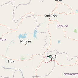
Map view of Kamuku National Park

Use this park location map to pinpoint Kamuku National Park in Nigeria, understand its exact geographic position, and read its mapped placement within the surrounding landscape more clearly.

Pigeon | © OpenStreetMap contributors

Location context for Kamuku National Park

Kaduna State

A Visual Guide to Kamuku's Unique Ecosystems, Geologic Formations, and Diverse Protected Habitats

Kamuku National Park Photos: Explore Nigeria's Savanna Landscapes and Dramatic Inselberg Scenery

Browse comprehensive imagery of Kamuku National Park to visually understand its distinctive Guinea Savanna ecosystem, prominent Goron Dutse inselberg, and diverse wildlife habitats. These curated park photos offer an invaluable resource for appreciating the rugged terrain, scenic waterfalls, and protected landscape character of this significant Nigerian conservation area.

A group of elephants standing on a sandy shore near a body of water with dense green vegetation in the background.

Park atlas

Compare savanna ecosystems and unique inselberg landscapes in the regional park geography.

Discover Other National Parks and Protected Areas Surrounding Kamuku National Park

Expand your protected area discovery from Kamuku National Park, exploring other national parks and protected landscapes within Nigeria and the surrounding regional geography. This allows you to map diverse savanna ecosystems and compare distinct geological features, including impressive inselbergs and riverine forests.
Wildlife reserveNigeria
About 190 km away#1 closest

South

Lower Kaduna-Middle Niger Floodplain: Protected Wildlife Reserve and Wetland Atlas

An expansive floodplain corridor in the heart of Nigeria

Spanning the confluence of the Niger and Kaduna rivers, this wildlife reserve preserves a critical mosaic of swamps, sandbanks, and flooded grasslands. The area is defined by its seasonal inundation cycles and vital role as a refuge for bird populations within the Guinea savanna. Explore the mapped boundaries and natural terrain of this unique aquatic environment.

Area
2,290.54 km²
Established
2008
Relief
Lowland
Climate
Tropical
Protected areaSierra Leone
About 208 km away#2 closest

Foge Islands Protected Area: Geographic Boundaries and Wetland Landscape

Key protected area in Sierra Leone

The Foge Islands function as a vital protected area characterized by dynamic wetland landscapes and shifting fluvial boundaries. This resource provides a focused geographic overview of the island terrain, detailing the environmental features and regional placement within the wider Sierra Leone landscape. Understand the physical composition and ecological importance of this unique protected site through detailed map-driven analysis.

Area
42.287 km²
Established
2008
Relief
Lowland
Climate
Tropical
National parkNigeria
About 217 km away#3 closest

West

Kainji National Park: Nigeria's National Park for Geographic Discovery

Mapped protected landscape and regional geographic context.

Kainji National Park represents a significant protected landscape within Nigeria, offering a distinct focal point for geographic atlas exploration. As a national park, its mapped boundaries and regional context are essential for understanding the distribution of natural areas in West Africa. This entry provides a grounded perspective on its landscape, enabling detailed study for those interested in the structured geography of conservation lands.

Area
5,340.82 km²
Established
1978
IUCN
II
Relief
Lowland
Nature reserveMaradi Region
About 292 km away#4 closest

North

Madarounfa Lake Nature Reserve: Geographic Overview of Niger's Premier Wetland

Seasonal wetlands and riparian habitats in Maradi Region

Madarounfa Lake functions as a pivotal natural feature in the Maradi Region, blending seasonal hydrological shifts with a distinct cultural identity. This protected area supports critical riparian woodland and waterbird populations, serving as an essential resource for the surrounding landscape. Its classification as a wetland of international importance highlights the environmental complexity of the Sahel-Sudanese transition zone.

Area
8.5 km²
Established
2019
Relief
Lowland
Scope
Terrestrial
Nature reserveMaradi Region
About 296 km away#5 closest

North

Geschützter Wald von Madarounfa: Protected Woodland and Nature Reserve in the Maradi Region

Mapping the Sahel-Sudan transition landscapes of Niger.

Located in the Maradi Region, this nature reserve protects a rare mosaic of dryland vegetation, including acacia and tamarind groves on alluvial soils. The woodland functions as a critical environmental anchor within the surrounding agricultural plains, offering a window into the natural history of the Goulbi de Maradi river valley.

Area
8.3 km²
Established
1950
Relief
Lowland
Climate
Subtropical
Protected areaDosso Region
About 327 km away#6 closest

Northwest

Dallol Maouri Protected Area: Geographic Overview of Niger's Fossilized Wetland Valleys

Mapping seasonal pond systems and floodplain corridors in the Dosso Region

Dallol Maouri serves as a quintessential example of the ancient drainage systems found in the Iullemmeden Basin. As a Ramsar-listed protected area, it features a unique north to south orientation that fosters a rich transition between dryland Sahel and Sudanian savanna. The valley is defined by its seasonal mares, palm groves, and intricate network of koris tributaries that shape the geography of southwestern Niger.

Area
3,175.2 km²
Established
2004
Relief
Lowland
Climate
Subtropical
Wildlife reserveDosso Region
About 329 km away#7 closest

West

Feuchtgebiet am mittleren Niger II: Wetland Geography and Wildlife Reserve Boundaries

A seasonal floodplain corridor in the Dosso Region of Niger.

Feuchtgebiet am mittleren Niger II offers a clear view into the flood-pulse ecology of the middle Niger River. The reserve comprises a complex network of channels, ponds, and riverine woodlands that shift with the annual rains. This protected site in the Dosso Region acts as a crucial transboundary conservation area, showcasing the unique interaction between riparian forests, baobab groves, and seasonal aquatic terrain.

Area
385.55 km²
Established
2004
Relief
Lowland
Scope
Terrestrial
Wildlife reserveNassarawa
About 353 km away#8 closest

Southeast

Pandam Wildlife Park: Geographic Overview and Protected Area Mapping

Wetland and savanna ecosystems of the Bauchi Plateau

Pandam Wildlife Park serves as a centerpiece for wetland conservation in Nigeria, protecting a diverse matrix of seasonal floodplains, savanna woodlands, and gallery forests. This entry provides geographic data on the reserve, focusing on the seasonal connectivity of Pandam Lake and its role in maintaining a rich corridor of biodiversity across the Nassarawa regional boundary.

Area
197.42 km²
Established
1972
Visitors
27K annual
Relief
Lowland

Common questions about visiting, size, designation, and location context for Kamuku National Park

Kamuku National Park FAQs for park facts, access, geography, and protected area context

Find quick answers about Kamuku National Park, including protected-area facts, park geography, trail and visitor context, and how the park fits into its surrounding country and regional landscape.
MoriAtlas Explorer

Continue Your Protected Areas Search Across the Global Atlas

Deepen your exploration by continuing the structured search for national parks and protected areas worldwide. Utilize the comprehensive filtering capabilities to compare different conservation landscapes and refine your understanding of global park geography. Discover more about the distribution and characteristics of protected natural areas.

Global natural geography