

Mori Atlas logo
National parkManupeu Tanah Daru National Park

Explore the mapped boundaries and geographic context of this significant national park.

Manupeu Tanah Daru National Park: Protected Landscape Identity and Regional Geography in East Nusa Tenggara

(Taman Nasional Manupeu Tanah Daru)

Manupeu Tanah Daru National Park stands as a key protected natural area within the East Nusa Tenggara region, offering a focal point for atlas-driven geographic discovery. This page provides essential context for understanding the park's protected landscape identity, its position within the regional geography, and its mapped boundaries. Engage with the core characteristics that define Manupeu Tanah Daru National Park as a distinct element in the global atlas of conservation lands.

Lowland forestEndemic speciesBirdwatchingSumbaEast Nusa TenggaraNational park

Manupeu Tanah Daru National Park

National park

Park overview

Structured park overview, official facts, and landscape profile for Manupeu Tanah Daru National Park

Manupeu Tanah Daru National Park park facts, protected area profile, and essential visitor context

Review the core facts for Manupeu Tanah Daru National Park, including designation, size, terrain, visitor scale, habitats, and operating context in one park-focused overview.

About Manupeu Tanah Daru National Park

Manupeu Tanah Daru National Park represents one of the most important protected areas in eastern Indonesia, safeguarding what remains of Sumba island's native lowland forests. The park was officially designated in 1998 through ministerial decree, encompassing a vast tract of forested land across the island's central and western regions. Unlike the more commonly known montane and cloud forests of Indonesia, this park protects a relatively rare ecosystem type: the remaining patches of deciduous lowland forest that once covered much of Sumba's terrain. The forest composition includes valuable timber species such as Toona sureni, Sterculia foetida, and Schleichera oleosa, as well as culturally important trees like tamarind and candlenut. The park's significance extends beyond simple biodiversity protection; it serves as a watershed for surrounding communities, helping to regulate water flow and prevent soil erosion across the island's agricultural lands. Visitor facilities remain limited, with accommodations primarily consisting of homestays operated by local communities in surrounding villages.

Quick facts and research context for Manupeu Tanah Daru National Park

Manupeu Tanah Daru National Park covers roughly 88,000 hectares on Sumba island in eastern Indonesia. The protected area was established in 1998 and represents one of the last significant remnants of the island's lowland forest ecosystems. Elevation within the park ranges from sea level to 918 meters. The park is notable for its high level of endemism, particularly among birds and butterflies, with seven bird species and seven butterfly species found only on Sumba. The park is accessible via a flight to Waingapu followed by a two-hour drive to the park headquarters near Waikabubak.

Protection and recognition

Tracing terrestrial conservation frameworks and documented boundaries within the global atlas.

Manupeu Tanah Daru National Park Official Protection Status and Geographic Scope

Establishment of Manupeu Tanah Daru National Park as a terrestrial protected area highlights the regional commitment to preserving critical ecological systems. Analyzing documented protection levels, terrestrial designations, and administrative boundaries offers essential geographic context for evaluating the regional conservation landscape.

Protection details

Protection scope
Terrestrial
Transboundary protection
No
Park context

Deeper park guide and search-rich context for Manupeu Tanah Daru National Park

Manupeu Tanah Daru National Park history, landscape, wildlife, and travel context

Explore Manupeu Tanah Daru National Park through its history, landscape character, ecosystems, wildlife, conservation priorities, cultural context, and seasonal travel timing in a structured park guide built for atlas discovery and search intent.

Why Manupeu Tanah Daru National Park stands out

Manupeu Tanah Daru National Park is best known for its exceptional endemism. The park protects the Sumba yellow-crested cockatoo, one of Indonesia's most threatened parrots, and the Sumba hornbill, a striking bird found only on this island. The protection of these endemic bird species, along with six other Sumba-specific bird taxa, makes the park internationally significant for avian conservation. The park also preserves seven endemic butterfly species, representing one of the most significant lepidoptera populations in the Lesser Sunda Islands. The Lapopu waterfall, one of the largest waterfalls in the region, provides a notable scenic attraction within the park boundaries.

Manupeu Tanah Daru National Park history and protected-area timeline

Manupeu Tanah Daru National Park was officially established in 1998 through the Ministry of Forestry Decree Number SK.576/Kpts-II/1998. The designation came after growing recognition that Sumba's lowland forests were disappearing at an alarming rate due to agricultural expansion, logging, and other human pressures. Prior to national park status, the area existed as a protected forest zone, but the formal protection under national park status provided stronger legal framework for conservation. The establishment reflected Indonesia's broader commitment to expanding its protected area network during the late 1990s. Since designation, management has been the responsibility of the Ministry of Environment and Forestry, with park headquarters located near Waikabubak, the main city in West Sumba district. The park remains one of the younger national parks in Indonesia, and its relatively recent establishment means that conservation infrastructure and visitor services continue to develop.

Manupeu Tanah Daru National Park landscape and geographic character

The landscape of Manupeu Tanah Daru National Park is characterized by rolling hills and steep slopes that rise from the island's coastal plains to elevations of approximately 600 meters in the forest interior, with the highest points reaching 918 meters above sea level. The terrain consists of heavily dissected ridgelines and valleys that create a complex topography typical of tropical islands with monsoonal climate patterns. The park encompasses catchments and drainages that feed streams flowing toward the coast, and several notable waterfalls mark where these watercourses drop over exposed rock faces. The Lapopu waterfall stands as one of the most impressive natural features in the park. Beyond the forest, the park also includes coastal areas with beaches such as Maloba, Aili, Marababakul, Hipi, and Konda, providing a contrast between the forested interior and the island's shoreline ecosystems.

Manupeu Tanah Daru National Park ecosystems, habitats, and plant life

The park protects one of the last remaining examples of Sumba's lowland forest ecosystems, a habitat type that has been extensively cleared across the island for agriculture and settlements. The forest vegetation includes approximately 118 documented plant species representing both deciduous and evergreen components. The tree canopy is dominated by species including Toona sureni, Sterculia foetida, Schleichera oleosa, Alstonia scholaris, and various Syzygium species. The understory contains a mix of shrubs and smaller trees, with invasive species like Lantana camara present in some areas. The forest supports a complex ecological community that has evolved in isolation on Sumba, resulting in the high degree of endemism that makes this park particularly significant. The transition from coastal to interior habitats creates distinct ecological zones within the park, each supporting different species assemblages.

Manupeu Tanah Daru National Park wildlife and species highlights

The wildlife of Manupeu Tanah Daru National Park is distinguished by remarkable endemism, with seven bird species found exclusively on Sumba island. The most notable of these is the Sumba yellow-crested cockatoo, a critically endangered species that survives in significant populations only within this park and surrounding forested areas. The Sumba hornbill, another endemic species, is among the most sought-after birds by ornithologists visiting the park. Additional endemic bird species include the Sumba green pigeon, Sumba flycatcher, Sumba cicadabird, and apricot-breasted sunbird. Together, these 87 bird species represent a remarkable concentration of avifauna for such a limited area. The park also protects 57 butterfly species, including seven endemics such as Papilio neumoegenii, Ideopsis oberthurii, and Delias fasciata. This lepidoptera diversity further underscores the island's significance as a center of endemism in the Wallacea region.

Manupeu Tanah Daru National Park conservation status and protection priorities

Manupeu Tanah Daru National Park plays a crucial role in conserving one of Indonesia's most endemic-rich forest ecosystems. The park protects habitat for multiple threatened species, most notably the Sumba yellow-crested cockatoo, which faces severe threats from habitat loss and illegal trapping for the cage bird trade. The Sumba hornbill is similarly endangered and depends on the forest interior that the park safeguards. As the representative of the last significant tracts of Sumba's lowland forest, the park serves as a refuge for species that cannot survive in the degraded agricultural landscapes that dominate most of the island. Conservation challenges include managing the boundary between park protection and the needs of local communities who depend on the surrounding land for agriculture and grazing. The park's relatively recent establishment and limited infrastructure present ongoing challenges for effective management and enforcement.

Manupeu Tanah Daru National Park cultural meaning and human context

The park lies within a region of strong cultural significance on Sumba island, where traditional village life and ancient customs remain integral to daily life. Near the park headquarters in the Waikabubak area, visitors can observe traditional carved stone tombs that represent important social and spiritual markers in Sumba culture, with sites such as Kadung Tana, Watu Karagata, and Bulu Peka Mila demonstrating the island's rich mortuary traditions. The Pasola ritual, a dramatic traditional ceremony involving horsemen with wooden spears, takes place in nearby districts during February and March and represents one of the most significant cultural events in the region. Local communities surrounding the park practice traditional agriculture and maintain connections to the forest through resource use and cultural practices. Visitor accommodations through community-managed homestays provide opportunities for cultural exchange while supporting local livelihoods.

Top sights and standout views in Manupeu Tanah Daru National Park

Manupeu Tanah Daru National Park offers a combination of forest wildlife, endemic species, and natural scenery that distinguishes it among Indonesia's protected areas. The opportunity to observe the Sumba yellow-crested cockatoo and Sumba hornbill in their natural habitat draws ornithologists and wildlife enthusiasts from around the world. The park's waterfalls, particularly Lapopu, provide scenic attractions that complement the biological highlights. The mix of forest and coastal ecosystems allows visitors to experience both inland and shoreline environments within a single protected area. The proximity to traditional Sumba villages and cultural sites adds dimension to visits, especially for those interested in the intersection of nature and culture in eastern Indonesia.

Best time to visit Manupeu Tanah Daru National Park

The optimal visiting season for Manupeu Tanah Daru National Park spans two periods: March through June and October through December. These months correspond to the drier seasons when conditions are most favorable for wildlife viewing and forest exploration. The wetter months can make some trails difficult to navigate and may reduce visibility for birdwatching. The park's location on Sumba means that visiting during the dry season provides more comfortable conditions for outdoor activities. Visitors should note that facilities within the park remain limited, and most travelers combine a park visit with cultural exploration of Sumba island, often arriving with expectations shaped by their broader itinerary.

Monthly climate preview

Analyzing long term temperature trends and seasonal rainfall patterns in East Nusa Tenggara

Climate Normals and Weather by Month for Manupeu Tanah Daru National Park

Long term climatology measurements for Manupeu Tanah Daru National Park show consistently warm temperatures year round paired with highly seasonal daily precipitation. Comparing monthly climate averages over a thirty year period reveals detailed shifts in regional moisture levels and minimum temperatures across the low elevation landscape.
Annual mean27 °C
26 °C29 °C
Jan27°
Feb27°
Mar27°
Apr27°
May27°
Jun26°
Jul26°
Aug26°
Sep28°
Oct29°
Nov29°
Dec28°
Warmest month
November

28.9 °C

Coolest month
July

25.8 °C

Wettest month
February

7.1 mm/day

Driest month
August

0.2 mm/day

Park location guide

Geography guide, regional context, and park location map for Manupeu Tanah Daru National Park

Manupeu Tanah Daru National Park park geography, regions, and map view in Indonesia

Understand where Manupeu Tanah Daru National Park sits in Indonesia through a broader geographic reading of the surrounding landscape, nearby location context, and its mapped position within the national park landscape.

How Manupeu Tanah Daru National Park fits into Indonesia

Indonesia is a vast archipelagic nation in Southeast Asia and Oceania, spanning over 17,000 islands between the Indian and Pacific Oceans. As the world's fourth-most populous country with 288 million people, it features extraordinary cultural and biological diversity, withJavanese and Sundanese being the largest ethnic groups. The country gained independence from the Netherlands in 1945 and operates as a unitary presidential republic.

Wider geography shaping Manupeu Tanah Daru National Park in Indonesia

Indonesia is situated in Southeast Asia and Oceania, spanning the equatorial region between the Indian Ocean to the west and the Pacific Ocean to the east. The archipelago includes major islands such as Sumatra, Java, Sulawesi, and parts of Borneo and New Guinea. It borders Papua New Guinea, Timor-Leste, and Malaysia by land, with extensive maritime boundaries throughout the region.

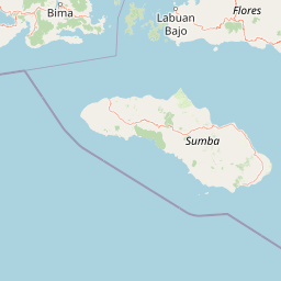
Map view of Manupeu Tanah Daru National Park

Use this park location map to pinpoint Manupeu Tanah Daru National Park in Indonesia, understand its exact geographic position, and read its mapped placement within the surrounding landscape more clearly.

Pigeon | © OpenStreetMap contributors

Location context for Manupeu Tanah Daru National Park

East Nusa Tenggara
Park atlas

Expand your protected area discovery by comparing national parks and conservation landscapes across Sumba Island and the surrounding Indonesian region.

Discover Nearby National Parks and Protected Areas Beyond Manupeu Tanah Daru National Park

Browse a curated selection of other national parks and protected areas located near Manupeu Tanah Daru National Park, extending your geographic discovery across Sumba Island and the wider East Nusa Tenggara province. This contextual view allows for direct comparison of landscape types, conservation focuses, and regional ecological patterns, deepening your understanding of Indonesian protected-area geography.
National parkSumba
About 66 km away#1 closest

Southeast

Laiwangi Wanggameti National Park: Protected Landscape and Geographic Atlas

Explore the mapped boundaries and regional context of this national park.

Laiwangi Wanggameti National Park serves as a vital protected area within Indonesia's Sumba region. This entry facilitates a deep dive into the park's specific geography, offering insights into its mapped protected boundaries and its contribution to the regional landscape. Users can engage with structured data to understand the park's unique natural identity and its place within a broader atlas of protected lands, focusing on geographic context and landscape characteristics.

Area
470.14 km²
Established
1998
IUCN
II
Scope
Terrestrial
National parkEast Nusa Tenggara
About 100 km away#2 closest

North

Komodo National Park: National Park Protected Landscape Atlas Entry

Mapped boundaries and regional geography for this Indonesian protected area.

Delve into the atlas representation of Komodo National Park, an essential protected landscape within the East Nusa Tenggara region of Indonesia. This entry highlights the park's mapped boundaries and its distinctive geographic setting. Understand the park's role as a national park and its contribution to the structured exploration of protected areas and natural landscapes across the Lesser Sunda Islands.

Area
1,733 km²
Established
1980
IUCN
II
Visitors
45K annual
National parkEast Nusa Tenggara
About 261 km away#3 closest

Northeast

Kelimutu National Park: Volcanic Terrain and Colored Crater Lakes in East Nusa Tenggara

Explore the mapped geography of this unique Indonesian national park.

Kelimutu National Park represents a remarkable protected landscape in East Nusa Tenggara, Indonesia, distinguished by its volcanic origins and the famed three colored lakes of Mount Kelimutu. This national park protects diverse montane forests and offers a unique insight into the region's geological wonders. Its geography features volcanic slopes and the iconic caldera, making it a significant point of interest for atlas-driven exploration of protected natural areas.

Area
50 km²
Established
1992
IUCN
II
Visitors
12.5K annual
National parkIndonesia
About 374 km away#4 closest

Northeast

Taka Bonerate National Park: National Park Geography and Protected Landscape Atlas

Understand the mapped boundaries and regional context of Taka Bonerate National Park

Explore Taka Bonerate National Park as a key protected area within Indonesia, focusing on its geographic identity and atlas significance. This entry provides structured information on the park's role as a national park, highlighting its landscape context and mapped terrain. Users can gain a clear understanding of Taka Bonerate National Park's place within Indonesia's diverse geography and its protected land features through detailed map-oriented discovery.

National parkIndonesia
About 388 km away#5 closest

West

Mount Rinjani National Park: Indonesia's Premier Volcanic Protected Landscape

Mapped geography and ecological transitions of a prominent Indonesian national park.

Mount Rinjani National Park is a key protected area in Indonesia, distinguished by its active stratovolcano and the striking Segara Anak crater lake. The park's landscape features steep volcanic slopes and diverse vegetation zones, from tropical rainforest to subalpine terrain. This detailed entry provides essential atlas context, focusing on the park's geographic boundaries, its unique volcanic geology, and its significance as a protected natural landscape within Indonesia's archipelagic geography.

Area
413 km²
Established
1990
IUCN
II
Relief
Mountain
Marine protected areaWestern Australia
About 412 km away#6 closest

South

Argo-Rowley Terrace Marine Park: Mapped Geography and Marine Protected Area Context

Expansive oceanic territory within the Western Australian region

Argo-Rowley Terrace Marine Park represents a vast offshore environment protecting diverse aquatic life and unique seafloor features. This marine protected area bridges the gap between the isolated Rowley Shoals and deep-water abyssal hills. The region is essential for understanding the structural geology of the ocean floor, encompassing everything from shallow reefs to abyssal plains in the remote north-west of Australia.

Area
146,003 km²
Established
2018
IUCN
VI
Relief
Lowland
Marine protected areaAustralia
About 446 km away#7 closest

Southeast

Ashmore Reef Marine Park: Mapping Australia's Remote Timor Sea Protected Marine Landscape

Deep-water coral reef flats, seagrass meadows, and migratory seabird rookeries.

Located in the remote outer Timor Sea, Ashmore Reef Marine Park acts as a major hub for marine biodiversity and bird conservation. The protected area features emergent islands, sheltered lagoons, and expansive intertidal flats that demonstrate complex oceanic influence from the Indonesian Throughflow. Examine the regional geography and protected boundaries of this vital offshore sanctuary within the Australian marine jurisdiction.

Area
583 km²
Established
1983
IUCN
Ia
Relief
Lowland
Marine protected areaAustralia
About 517 km away#8 closest

Southeast

Cartier Island Marine Park: Geographic Boundaries and Marine Sanctuary Overview

Remote Timor Sea reef systems and protected pelagic landscapes in Australian waters.

Cartier Island Marine Park functions as a strictly managed sanctuary zone, preserving the delicate balance of emergent reefs and open-ocean ecosystems within the North West Shelf. The area is characterized by its isolation, featuring complex reef flats and critical habitats that support significant sea snake populations, foraging marine turtles, and diverse seabird breeding colonies. This atlas entry examines the physical terrain and protected marine boundaries of the site.

Area
172 km²
Established
2000
IUCN
Ia
Relief
Lowland

Common questions about visiting, size, designation, and location context for Manupeu Tanah Daru National Park

Manupeu Tanah Daru National Park FAQs for park facts, access, geography, and protected area context

Find quick answers about Manupeu Tanah Daru National Park, including protected-area facts, park geography, trail and visitor context, and how the park fits into its surrounding country and regional landscape.
MoriAtlas Explorer

Continue Your Protected Areas Search Across the Global Atlas

Deepen your exploration by continuing the structured search for national parks and protected areas worldwide. Utilize the comprehensive filtering capabilities to compare different conservation landscapes and refine your understanding of global park geography. Discover more about the distribution and characteristics of protected natural areas.

Global natural geography