Mori Atlas logo
National parkPituamkek National Park Reserve

Explore the mapped boundaries and protected landscape identity of this national park.

Pituamkek National Park Reserve: National Park Detail and Geographic Context on Prince Edward Island

Pituamkek National Park Reserve represents a significant protected area within the geography of Prince Edward Island. This canonical page provides detailed atlas-level insight into the park's identity as a national park, focusing on its mapped boundaries and its role within regional conservation landscapes. Users can understand the park's specific geographic context and its significance as a protected natural entity, offering a factual basis for exploring Canada's protected areas.

Barrier IslandsCoastal DunesNew National ParkIndigenous Co-ManagementImportant Bird AreaMi'kmaq Heritage

Pituamkek National Park Reserve

National park

Park overview

Structured park overview, official facts, and landscape profile for Pituamkek National Park Reserve

Pituamkek National Park Reserve park facts, protected area profile, and essential visitor context

Review the core facts for Pituamkek National Park Reserve, including designation, size, terrain, visitor scale, habitats, and operating context in one park-focused overview.

About Pituamkek National Park Reserve

Pituamkek National Park Reserve represents a significant addition to Canada's national park system, established in 2024 along the northern coastline of Prince Edward Island. The reserve protects a 50-kilometre chain of barrier islands that stretch from the Cascumpec Sand Hills in the northwest to the Malpeque Sand Hills in the southeast, with the Conway Sand Hills occupying the middle section. These dynamic coastal landforms separate Cascumpec and Malpeque Bays from the Gulf of St. Lawrence, playing a crucial role in protecting Prince Edward Island's main shoreline from storm events and coastal erosion.

The park reserve encompasses not only the barrier island chain but also adjacent mainland areas, including Oulton's Island near Alberton, Hog Island positioned near the Lennox Island First Nation, and several smaller islands in Malpeque Bay such as Bird, Ram, and Courtin Islands. A strip of land along the Prince Edward Island shore also falls within the reserve's scope. While the total estimated protected area is approximately 30 square kilometres, the official boundaries of the park reserve remain under finalization, reflecting the ongoing nature of this protected area establishment.

The creation of Pituamkek National Park Reserve represents a landmark achievement in collaborative conservation, emerging from more than a decade of negotiation between the Mi'kmaq First Nations of Prince Edward Island and federal-provincial governments. The July 2024 co-management agreement between the Mi'kmaq of Prince Edward Island and Parks Canada sets a precedent for Indigenous partnership in national park stewardship, recognizing both the ecological importance and cultural heritage of this coastal landscape.

Quick facts and research context for Pituamkek National Park Reserve

Located on the northern coast of Prince Edward Island, Pituamkek National Park Reserve protects a chain of barrier islands and adjacent shoreline totaling approximately 30 square kilometres. The reserve encompasses the Cascumpec, Conway, and Malpeque Sand Hills, along with islands including Hog Island near the Lennox Island First Nation and several smaller islands in Malpeque Bay. The area features Iron Rock, the only volcanic incursion in the province. Both Cascumpec and Malpeque Bays are designated Important Bird Areas. The park was formally established on July 4, 2024, through a co-management agreement between the Mi'kmaq of Prince Edward Island and Parks Canada, representing the first new national park in Canada in years and a significant step in Indigenous protected area stewardship.

Protection and recognition

A detailed breakdown of official designation history and environmental management scope

Pituamkek National Park Reserve Protection Status and Designation

Browse the official protection status and conservation designation framework established for Pituamkek National Park Reserve in 2024. Reviewing documented management parameters provides essential geographic context for evaluating the reserve within the wider national network of protected areas.

Protection details

Protection scope
Mixed
Designated year
2024
Park context

Deeper park guide and search-rich context for Pituamkek National Park Reserve

Pituamkek National Park Reserve history, landscape, wildlife, and travel context

Explore Pituamkek National Park Reserve through its history, landscape character, ecosystems, wildlife, conservation priorities, cultural context, and seasonal travel timing in a structured park guide built for atlas discovery and search intent.

Why Pituamkek National Park Reserve stands out

Pituamkek is best known for its distinctive barrier island chain that forms a natural protective barrier along Prince Edward Island's Gulf of St. Lawrence coast. The park preserves the Cascumpec, Conway, and Malpeque Sand Hills, which support significant dune ecosystems and provide critical habitat for threatened species including the piping plover and little brown bat. The area contains Iron Rock, an unusual igneous rock formation representing the province's only volcanic incursion. The park is also notable for its deep Mi'kmaq heritage, with the name Pituamkek meaning "at the long sand dune" and archaeological evidence of Indigenous use spanning four millennia. The 2024 establishment represents a modern model of Indigenous-Canada co-management in national park creation.

Pituamkek National Park Reserve history and protected-area timeline

The history of Pituamkek stretches back at least 4,000 years, with archaeological evidence confirming continuous Indigenous presence and use of the barrier islands as traditional hunting and fishing grounds from the Woodlands period through post-European contact. The Mi'kmaq name Pituamkek, meaning "at the long sand dune," reflects the deep cultural connection between Indigenous peoples and this coastal landscape.

In 1942, the Canadian government purchased Hog Island to be added to the nearby Lennox Island First Nation, though the purchased land was never formally designated as a reserve. On December 3, 1996, the Lennox Island First Nation submitted a Specific Land Claim over Hog Island to Canada, initiating a process that would eventually intersect with broader conservation negotiations.

The modern protected area movement began in 2009 when Mi'kmaq band governments of Prince Edward Island started lobbying provincial and federal governments for formal protection of the land. That same year, the Nature Conservancy of Canada and Island Nature Trust began purchasing land on the Cascumpec and Conway Sand Hills to support conservation objectives. In 2006, representatives from the Lennox Island and Abegweit First Nations along with the Canadian Museum of Civilization conducted a survey identifying several archaeological sites, including a shell midden dating to 2,300 years before present known as pitawelkek ("where tea is made"), which showed evidence of seasonal fishing, shellfish harvesting, seal and walrus hunting, and tool-making activities.

A feasibility assessment for a new national park reserve was announced on August 14, 2019. The 2024-25 Canadian federal budget, released on April 16, 2024, committed CA$71.9 million over twelve years to establish the park reserve, plus CA$7.5 million annually for operations. The park reserve was formally established through the co-management agreement signing on July 4, 2024.

Pituamkek National Park Reserve landscape and geographic character

The landscape of Pituamkek National Park Reserve is defined by its dynamic barrier island system, a chain of sand deposits that parallel the Prince Edward Island coast and separate shallow bays from the open waters of the Gulf of St. Lawrence. These barrier islands represent a constantly evolving coastal environment shaped by wind, waves, and tidal forces. The 50-kilometre chain includes three main dune complexes: the Cascumpec Sand Hills in the northwest, the Conway Sand Hills occupying the central section, and the Malpeque Sand Hills in the southeast.

The sand dunes rise above the surrounding coastal plain, creating a distinctive topography that supports specialized plant communities adapted to sandy, exposed conditions. Between the barrier islands and the mainland lie Cascumpec Bay and Malpeque Bay, both shallow marine environments that contribute to the ecological richness of the region.

One of the most distinctive geological features within the reserve is Iron Rock, an unusual igneous rock formation that represents the only volcanic incursion in Prince Edward Island. This ancient volcanic remnant stands as evidence of the deep geological processes that shaped the region long before the contemporary coastal dune systems developed. The combination of dune systems, tidal bays, and this rare volcanic formation creates a landscape of considerable scientific and aesthetic interest.

Pituamkek National Park Reserve ecosystems, habitats, and plant life

The nature of Pituamkek centers on a complex coastal ecosystem where dune habitats, marine wetlands, and tidal flats support remarkable biodiversity. The barrier islands and their associated sand hills provide critical habitat for specialized plant species adapted to the challenging coastal environment, including dune grasses and salt-tolerant vegetation that stabilize the shifting sands.

Cascumpec Bay and Malpeque Bay, which the barrier islands help protect from direct Gulf of St. Lawrence exposure, have been designated as Important Bird Areas, recognition of their significance for migratory and nesting bird populations. The sand dunes within the park reserve serve as important nesting grounds, providing protected locations where ground-nesting birds can raise their young away from human disturbance and many predators.

The dune ecosystems support several threatened species, most notably the piping plover, a small shorebird that breeds on sandy beaches and is listed as a species of conservation concern across its range. The little brown bat, another species of note found within the reserve, occupies the dune areas where suitable roosting habitat exists. These species represent the ecological values that the protected area designation aims to preserve, ensuring that the coastal habitats remain functional for generations to come.

Pituamkek National Park Reserve wildlife and species highlights

The wildlife of Pituamkek reflects the rich biodiversity of Prince Edward Island's northern coastal zone. The sand dune environments provide crucial breeding and nesting habitat for the piping plover, a small shorebird whose populations have faced significant declines across North America, making the protected dunes essential for species survival. The little brown bat, a common but increasingly concerning species due to white-nose syndrome affecting bat populations elsewhere, finds suitable roosting habitat within the dune complex.

The bays separated by the barrier islands, particularly Cascumpec Bay and Malpeque Bay, support diverse marine and bird communities. As Important Bird Areas, these waters attract migratory waterfowl, shorebirds, and seabirds throughout the year, with seasonal concentrations during spring and fall migrations providing spectacular birdwatching opportunities. The intertidal zones support clam beds and other invertebrates that sustain foraging bird populations and represent traditional harvesting areas for local communities.

Historical records indicate that the islands supported populations of seal and walrus in times past, though the current status of these marine mammals in the area would require more recent survey data to characterize accurately. The overall wildlife community reflects the transition between terrestrial dune ecosystems and marine coastal environments that defines this distinctive protected area.

Pituamkek National Park Reserve conservation status and protection priorities

Pituamkek National Park Reserve represents an important conservation achievement for several interconnected reasons. The protected area preserves the last significant chain of barrier islands and sand dune systems along Prince Edward Island's north coast, ensuring that these dynamic coastal ecosystems remain intact against development pressures that have altered much of the island's shoreline. The establishment of the park provides formal federal protection for critical piping plover habitat, contributing to recovery efforts for this threatened species across its Canadian range.

The co-management structure between Parks Canada and the Mi'kmaq of Prince Edward Island represents a significant evolution in Canadian protected area management, moving toward models that recognize Indigenous governance and knowledge systems. This approach acknowledges that the ecological values of the area are inseparable from the cultural values that Indigenous peoples have maintained over millennia.

The financial commitment of CA$71.9 million over twelve years for establishment and CA$7.5 million annually for operations demonstrates a substantial federal investment in both the ecological and cultural dimensions of this protected area. The ongoing boundary finalization process indicates that the protected area may expand further, potentially increasing the conservation footprint and protection of additional coastal habitats.

Pituamkek National Park Reserve cultural meaning and human context

The cultural context of Pituamkek is profoundly shaped by millennia of Mi'kmaq presence and continued connection to this coastal landscape. The name Pituamkek itself, meaning "at the long sand dune" in the Mi'kmaq language, reflects a worldview that centers the landscape as part of cultural identity rather than separate from it. Archaeological evidence of Indigenous use dates to approximately 4,000 years before present, with continuous occupation and use through the Woodlands period and into the historical era following European contact.

The 2006 archaeological survey conducted jointly by the Lennox Island and Abegweit First Nations and the Canadian Museum of Civilization revealed sites of significant cultural value. Among these was the pitawelkek shell midden, dating to 2,300 years before present, named for the tea-like color of the sediment and showing evidence of seasonal habitation for fishing, shellfish harvesting, seal and walrus hunting, and tool-making activities including pottery production.

The park's establishment through a co-management agreement acknowledges the Mi'kmaq as partners in stewardship rather than stakeholders to be consulted, representing a meaningful shift in how protected areas interact with Indigenous communities. The continued involvement of the Lennox Island and Abegweit First Nations in managing the reserve ensures that Indigenous knowledge and perspectives inform ongoing management decisions.

Top sights and standout views in Pituamkek National Park Reserve

Pituamkek National Park Reserve stands as Canada's newest national park, protecting a rare barrier island chain along Prince Edward Island's Gulf of St. Lawrence coast. The 50-kilometre stretch of sand hills and islands represents the last significant undeveloped coastal dune system in the province. The park features Iron Rock, the province's only volcanic rock formation, a geological anomaly that provides insight into the ancient volcanic history beneath the island. The area serves as critical habitat for piping plovers and other threatened species, with both adjacent bays designated as Important Bird Areas. The 2024 establishment represents a groundbreaking co-management partnership between Parks Canada and the Mi'kmaq of Prince Edward Island, the first new national park in Canada in years and a model for Indigenous partnership in protected area stewardship. Archaeological evidence documents 4,000 years of continuous Indigenous connection to these lands.

Best time to visit Pituamkek National Park Reserve

As a newly established park reserve with boundaries still being finalized, visitor infrastructure and programming for Pituamkek will likely develop over coming years. The coastal location means that visiting during the warmer months from May through September offers the most comfortable conditions for exploring the outdoor environments. The spring migration period in April and May brings heightened bird activity to the bay areas, while late summer provides opportunities for observing shorebird populations as they prepare for their southward migration. The barrier islands and beach environments are most accessible during low tide periods, when the sand flats and tidal zones expand. Visitors interested in experiencing the cultural dimensions of the park should note that any future interpretive programming will likely reflect the Mi'kmaq perspective and knowledge systems that are central to the co-management approach.
Monthly climate preview

Long-term representative monthly temperature and precipitation data patterns

Pituamkek National Park Reserve Climate Normals and Annual Temperature Rhythm

Pituamkek National Park Reserve exhibits a measured annual cycle of monthly temperature variations and consistent precipitation patterns based on historical coordinates. Examining the complete twelve-month climatology dataset reveals deeper statistical breakdowns for average maximum and minimum temperatures.
Annual mean6 °C
-7 °C19 °C
Jan-7°
Feb-7°
Mar-3°
Apr
May
Jun14°
Jul19°
Aug19°
Sep15°
Oct
Nov
Dec-2°
Warmest month
August

18.7 °C

Coolest month
February

-6.9 °C

Wettest month
October

3.3 mm/day

Driest month
March

2.4 mm/day

Park location guide

Geography guide, regional context, and park location map for Pituamkek National Park Reserve

Pituamkek National Park Reserve park geography, regions, and map view in Canada

Understand where Pituamkek National Park Reserve sits in Canada through a broader geographic reading of the surrounding landscape, nearby location context, and its mapped position within the national park landscape.

How Pituamkek National Park Reserve fits into Canada

Canada is a federal parliamentary constitutional monarchy spanning North America from the Atlantic to the Pacific and Arctic Oceans. With a population of over 41 million, it is officially bilingual in English and French at the federal level. The country gained independence from the United Kingdom through a gradual process culminating in 1982.

Wider geography shaping Pituamkek National Park Reserve in Canada

Canada occupies the northern portion of North America, sharing its longest international border with the United States. The country extends from the Atlantic Ocean to the Pacific Ocean and northward into the Arctic Ocean, giving it the longest coastline of any nation.

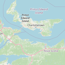
Map view of Pituamkek National Park Reserve

Use this park location map to pinpoint Pituamkek National Park Reserve in Canada, understand its exact geographic position, and read its mapped placement within the surrounding landscape more clearly.

Pigeon | © OpenStreetMap contributors

Location context for Pituamkek National Park Reserve

Prince Edward Island
Park atlas

Explore adjacent coastal landscapes and barrier island systems, comparing protected geography in Atlantic Canada.

Discover More Protected Areas Near Pituamkek National Park Reserve, Prince Edward Island

Browse other national parks and protected areas within Prince Edward Island and the broader Atlantic Canada region, revealing diverse coastal ecosystems, unique barrier islands, and significant conservation landscapes. Expand your geographic understanding of protected lands beyond Pituamkek National Park Reserve, tracing similar dune systems, coastal habitats, and regional park distributions.
National parkPrince Edward Island
About 35 km away#1 closest

Southeast

Prince Edward Island National Park: A Mapped Protected Landscape within Canada's Maritime Region

Discover its geographic context and natural terrain.

Prince Edward Island National Park offers a distinct protected area for exploration within the Canadian Maritimes. As a national park, it represents a commitment to preserving specific natural landscapes and their geographic characteristics. This resource provides insight into its mapped boundaries, regional setting on Prince Edward Island, and its contribution to the broader atlas of protected lands.

Area
27 km²
Established
1937
IUCN
II
Relief
Lowland
Wildlife reserveNew Brunswick
About 57 km away#2 closest

South

Réserve nationale de faune du Cap-Jourimain: Protected Coastal Wetlands and Wildlife Maps

Essential geographic context for a strategic New Brunswick wildlife reserve

Examine the mapped boundaries and complex ecosystem transitions of Réserve nationale de faune du Cap-Jourimain. This federally protected area in New Brunswick offers a distinct look at coastal marshlands, tidal flats, and island topography situated at the narrowest point of the Northumberland Strait.

Area
6.617 km²
Established
1980
IUCN
IV
Relief
Lowland
National parkNew Brunswick
About 69 km away#3 closest

West

Kouchibouguac National Park: New Brunswick Protected Landscape Atlas

Mapped protected area boundaries and regional geography.

Kouchibouguac National Park is a designated national park offering a rich canvas for geographic discovery. This entry focuses on understanding its protected landscape, detailing its specific mapped boundaries within New Brunswick. It serves as a vital component for atlas exploration, providing the context needed to grasp the park's natural terrain and its significance within the regional geography.

Area
238 km²
Established
1969
IUCN
II
Visitors
243.5K annual
Wildlife reserveNova Scotia
About 101 km away#4 closest

South

Amherst Point Migratory Bird Sanctuary: Wetland Protected Landscape and Map Explorer

Nova Scotia Wildlife Reserve and Managed Marshland Habitat

Amherst Point Migratory Bird Sanctuary protects a significant freshwater marsh and ponded wetland network in Nova Scotia. This reserve is defined by its engineered diked impoundments and role as a crucial stopover for migratory birds in the Atlantic flyway, offering a clear window into managed wetland conservation and coastal marsh terrain.

Area
4.33 km²
Established
1947
IUCN
IV
Wildlife reserveNew Brunswick
About 105 km away#5 closest

Northwest

Île-du-Portage National Wildlife Area: Geographic Overview and Protected Island Mapping

A vital estuarine reserve on the New Brunswick coast

Study the coastal terrain of Île-du-Portage National Wildlife Area, an uninhabited island reserve situated at the junction of the Miramichi River and the Northumberland Strait. This overview focuses on the island's role as one of five National Wildlife Areas in New Brunswick, highlighting its significance within the broader estuarine geography and coastal maritime history of the Atlantic region.

Area
3.49 km²
Established
1979
IUCN
Ia
Relief
Lowland
Wildlife reserveNew Brunswick
About 126 km away#6 closest

Southwest

Réserve nationale de faune de Shepody: Geographic Overview of a New Brunswick Wildlife Reserve

Coastal wetlands and protected intertidal geography

Located along the Bay of Fundy, Réserve nationale de faune de Shepody represents an essential network of salt marshes and freshwater habitats. This mapping analysis traces the intersection of tidal dynamics, riverine estuaries, and ancient sandstone formations that define this critical protected area in New Brunswick.

Area
10.69 km²
Established
1980
IUCN
IV
Relief
Lowland
National parkNew Brunswick
About 135 km away#7 closest

Southwest

Fundy National Park: New Brunswick National Park Atlas and Geographic Exploration

Mapped protected landscape and regional park context.

Fundy National Park represents a vital protected area, offering rich geographic discovery within New Brunswick, Canada. This national park detail provides context for its mapped boundaries and landscape, supporting atlas-based exploration of its regional significance. Understand Fundy National Park's protected status and its contribution to the mapped natural terrain of eastern Canada.

Area
207 km²
Established
1948
IUCN
II
Visitors
303.6K annual
Wildlife reserveNova Scotia
About 171 km away#8 closest

South

Boot Island National Wildlife Area: Mapping Coastal Conservation in Nova Scotia

Protecting intertidal mudflats and migratory bird habitats

Located in the Southern Bight of the Minas Basin, Boot Island National Wildlife Area serves as a key protected refuge within the Bay of Fundy. This reserve safeguards essential coastal and marshland habitats that support migratory bird populations, offering a focused look at how specific island geography functions within a larger, dynamic estuarine wetland system.

Area
1.07 km²
Established
1979
IUCN
Ia
Relief
Lowland

Common questions about visiting, size, designation, and location context for Pituamkek National Park Reserve

Pituamkek National Park Reserve FAQs for park facts, access, geography, and protected area context

Find quick answers about Pituamkek National Park Reserve, including protected-area facts, park geography, trail and visitor context, and how the park fits into its surrounding country and regional landscape.
MoriAtlas Explorer

Continue Your Protected Areas Search Across the Global Atlas

Deepen your exploration by continuing the structured search for national parks and protected areas worldwide. Utilize the comprehensive filtering capabilities to compare different conservation landscapes and refine your understanding of global park geography. Discover more about the distribution and characteristics of protected natural areas.

Global natural geography