

Mori Atlas logo
National parkIbanda-Kyerwa National Park

Discover the savanna, riparian habitats, and tri-border significance of this Tanzanian national park.

Ibanda-Kyerwa National Park: Protected Landscape, Mapped Geography, and Regional Atlas Context

Ibanda-Kyerwa National Park represents a vital protected landscape in Tanzania's northwestern Kagera Region, defined by its unique tri-border geography adjacent to Uganda and Rwanda. As a national park established in 2019, it offers an expansive view of savanna grasslands and critical riparian habitats shaped by the Kagera River system. This page serves as your atlas entry point to understanding the park's mapped boundaries, its ecological significance, and its place within the broader regional geography, providing essential context for protected area discovery.

National ParkTanzaniaKagera RegionKyerwa DistrictTransboundary Protected AreaKagera River

Ibanda-Kyerwa National Park

National park

Park overview

Structured park overview, official facts, and landscape profile for Ibanda-Kyerwa National Park

Ibanda-Kyerwa National Park park facts, protected area profile, and essential visitor context

Review the core facts for Ibanda-Kyerwa National Park, including designation, size, terrain, visitor scale, habitats, and operating context in one park-focused overview.

About Ibanda-Kyerwa National Park

Ibanda-Kyerwa National Park represents Tanzania's commitment to expanding and strengthening its protected area network in the northwestern region of the country. Located in Kyerwa District within the Kagera Region, the park encompasses approximately 200 square kilometers of diverse terrain shaped by the Kagera River and its associated wetlands and floodplains. The park's location is geographically unique, sitting at Tanzania's western corner where it borders Uganda across the Kagera River and connects ecologically with Akagera National Park in Rwanda, creating a transboundary conservation corridor of considerable regional importance.

The establishment of the park in 2019 marked the culmination of a conservation journey that began in 1974 when the area was first designated as Ibanda Game Reserve. This upgrade to full national park status reflects both the ecological significance of the area and Tanzania's strategic interest in developing its northwestern tourism circuit. Unlike the well-established northern circuit parks that attract hundreds of thousands of visitors annually, Ibanda-Kyerwa offers a more intimate and remote wilderness experience, appealing to travelers seeking to explore lesser-known corners of Tanzania's protected landscape.

The park's governance falls under the Tanzanian National Parks Authority, which manages the protected area alongside other national parks throughout the country. Access to the park involves flying into Bukoba Airport from Dar es Salaam, followed by a road journey to the park entrance. This accessibility challenge, combined with the park's relatively recent establishment and limited tourism infrastructure, has contributed to its status as one of Tanzania's least-visited national parks, though government investments in tourism facilities signal growing interest in developing the park's visitor potential.

Quick facts and research context for Ibanda-Kyerwa National Park

Ibanda-Kyerwa National Park spans 200 square kilometers in Kyerwa District, Kagera Region, Tanzania, near the border with Uganda and Rwanda. The park was upgraded from Ibanda Game Reserve to national park status in 2019, making it one of Tanzania's newer protected areas. The Kagera River forms both the western boundary and the primary water source for the park's ecosystems. Wildlife includes hippos, antelopes, Thomson's gazelles, impalas, common elands, and baboons. The nearest city is Bukoba, accessible by air from Dar es Salaam. The park remains among the least-visited in Tanzania, with ongoing investments in tourism infrastructure.

Protection and recognition

Analysing terrestrial conservation bounds and transboundary park designations

Protection Status and Regional Designation of Ibanda-Kyerwa National Park

Geographic datasets verify the terrestrial protection status, designation history, and legal conservation framework governing Ibanda-Kyerwa National Park. Documented transboundary status highlights important ecological connectivity across national borders while outlining verified international conservation listings.

Protection details

Protection scope
Terrestrial
Transboundary protection
Yes
Park context

Deeper park guide and search-rich context for Ibanda-Kyerwa National Park

Ibanda-Kyerwa National Park history, landscape, wildlife, and travel context

Explore Ibanda-Kyerwa National Park through its history, landscape character, ecosystems, wildlife, conservation priorities, cultural context, and seasonal travel timing in a structured park guide built for atlas discovery and search intent.

Why Ibanda-Kyerwa National Park stands out

Ibanda-Kyerwa National Park is distinguished by its position at the crossroads of Tanzania, Uganda, and Rwanda, making it a unique tri-border protected area. The park is particularly known for its hippo populations in the Kagera River and the diverse antelope species that inhabit its savanna and woodland habitats. Its relatively untouched character and status as one of Tanzania's least-visited national parks offer visitors a rare opportunity to experience a remote wilderness far from the crowds that frequent more famous parks. The park's cultural significance as the former territory of the Karagwe Kingdom and ancestral lands of the Nyambo people adds historical depth to its natural attractions.

Ibanda-Kyerwa National Park history and protected-area timeline

The territory that now comprises Ibanda-Kyerwa National Park carries a rich historical legacy that predates its designation as a protected area. The land was the ancestral home to the Nyambo people, an ethnic group whose presence in the region extends back centuries. The area also formed part of the domain of the Karagwe Kingdom, a significant political entity in the Great Lakes region of East Africa before the era of European colonialism. The Karagwe Kingdom, known for its cattle wealth and trade networks, exercised influence over the territory that now falls within the park's boundaries, making this landscape historically significant beyond its ecological value.

The modern protected area history began in 1974 when the area was designated as Ibanda Game Reserve, providing initial legal protection for the region's wildlife and habitats. This designation maintained the area's conservation status for over four decades while allowing certain uses consistent with game reserve management. In 2019, the reserve was upgraded to national park status, a transformation that strengthened conservation protections and aligned the area with the higher standards of IUCN Category II protected areas. This upgrade reflected both the ecological importance of the region and Tanzania's vision for developing its national park system.

More recently, in 2024, the Tanzanian government invested approximately TSh 3.9 billion (about US$1.45 million) in developing tourism facilities within the park, signaling a commitment to increasing visitor access and developing the park as a tourism destination. This investment represents the latest chapter in the park's evolution from ancestral homeland to colonial territory, game reserve, and now national park.

Ibanda-Kyerwa National Park landscape and geographic character

The physical landscape of Ibanda-Kyerwa National Park is fundamentally shaped by the Kagera River, which forms the park's western boundary and serves as its lifeblood. The river creates a distinctive riparian environment characterized by riverine forests, wetlands, and floodplains that contrast with the surrounding terrestrial habitats. The Kagera River system is one of the major waterways in the Lake Victoria basin, and its presence in the park supports a range of ecological communities adapted to the aquatic and riparian environments.

Beyond the river corridor, the park encompasses savanna grasslands and woodland habitats typical of the Kagera Region's ecology. The terrain generally consists of gently undulating landscapes that reflect the ancient geological processes that have shaped this corner of Tanzania. The proximity to Uganda to the west and Rwanda to the southwest is reflected in the park's position at the edge of Tanzania's highland regions, where the landscape transitions toward the more mountainous terrain found in the neighboring countries.

Ibanda-Kyerwa National Park ecosystems, habitats, and plant life

The ecological character of Ibanda-Kyerwa National Park reflects its position in the Kagera Region, where multiple habitat types converge. The Kagera River and its associated wetlands form the ecological core of the park, supporting aquatic species and creating riparian zones that differ markedly from the surrounding savanna landscapes. The river provides crucial water resources in a region where seasonal rainfall patterns strongly influence habitat conditions and wildlife distribution.

The park's location in northwestern Tanzania places it within a biodiversity transition zone where species from different ecological regions overlap. The rainy season, occurring between January and April, transforms the landscape and sustains the productivity of the park's grasslands and woodlands. This seasonal pattern influences wildlife behavior and viewing opportunities, with the wet months bringing abundant vegetation and water availability across the park. The Kagera River's role as the main water source means that the river system essentially nourishes the entire park's ecological communities, from the riverine forests along its banks to the grasslands where large herbivores graze.

Ibanda-Kyerwa National Park wildlife and species highlights

Ibanda-Kyerwa National Park supports a diverse array of wildlife species that reflect the park's varied habitats and its position within Tanzania's northwestern ecosystems. The hippo population represents one of the park's most notable wildlife attractions, with these large mammals inhabiting the Kagera River and adjacent water bodies. Hippos are a characteristic species of Tanzania's riverine protected areas, and their presence in Ibanda-Kyerwa contributes to the park's ecological identity.

The antelope community within the park includes several species adapted to the savanna and woodland habitats. Thomson's gazelles, impalas, and common elands all occur within the park, representing different ecological niches and herd dynamics. These antelope species form the prey base for any predators present in the ecosystem and contribute to the park's status as a functional savanna protected area. Baboons represent the park's primate diversity, with these social mammals commonly observed in the park's terrestrial environments. While the Wikipedia source mentions these species groups, the park's transboundary position adjacent to Akagera National Park suggests potential for ecological connectivity that could support additional species movement and biodiversity.

Ibanda-Kyerwa National Park conservation status and protection priorities

The conservation significance of Ibanda-Kyerwa National Park extends beyond its individual boundaries to encompass regional transboundary protection goals. By bordering Akagera National Park in Rwanda and lying near the Ugandan border across the Kagera River, the park contributes to a network of protected areas that facilitate wildlife movement and ecosystem connectivity across national boundaries. This transboundary dimension is increasingly recognized as important for conservation effectiveness in East Africa, where migratory species and ecological processes often transcend national borders.

The upgrade from game reserve to national park status in 2019 represented a strengthening of conservation protections for the area. National park designation under IUCN Category II implies more stringent protection standards and management requirements than game reserve status, reflecting the park's ecological value and Tanzania's commitment to its long-term preservation. The park's relatively low visitor numbers, while presenting tourism development challenges, also mean that the protected area experiences less pressure from human activity than more-visited parks, potentially allowing natural processes to proceed with minimal disturbance.

Ibanda-Kyerwa National Park cultural meaning and human context

The cultural landscape of Ibanda-Kyerwa National Park carries historical significance rooted in the pre-colonial era. The park's territory was the ancestral homeland of the Nyambo people, an ethnic group with deep roots in the Kagera Region. Understanding this historical presence adds depth to the park's identity, moving beyond purely ecological considerations to recognize the long human history that has shaped and been shaped by this landscape. The relationship between the Nyambo people and the land predates the formal protected area boundaries that exist today, representing a connection to place that spans generations.

Additionally, the area was part of the domain of the Karagwe Kingdom, a significant political entity in the Great Lakes region during the pre-colonial period. The Karagwe Kingdom was known for its cattle-based economy and extensive trade networks that connected it to broader regional exchange systems. The historical significance of the Karagwe Kingdom adds a layer of cultural heritage to the park that distinguishes it from protected areas without such deep historical roots. These cultural dimensions provide context for understanding the landscape beyond its more recent designation as a protected area.

Top sights and standout views in Ibanda-Kyerwa National Park

Ibanda-Kyerwa National Park offers several standout features that distinguish it within Tanzania's national park system. Its position at the tri-border junction of Tanzania, Uganda, and Rwanda creates a unique geographic identity as a transboundary protected area connected to regional conservation networks. The Kagera River hippo populations represent a flagship wildlife viewing opportunity, with these large mammals providing memorable encounters for visitors who explore the riverine environments. The park's status as one of Tanzania's least-visited national parks is itself a highlight for travelers seeking remote, uncrowded wilderness experiences away from the more frequented parks. The 2019 establishment as a national park makes this a newly created protected area where visitors can be among the first to explore developing tourism infrastructure and trails. The cultural heritage spanning the Nyambo people and Karagwe Kingdom adds historical dimension that enriches the visitor experience.

Best time to visit Ibanda-Kyerwa National Park

The optimal time to visit Ibanda-Kyerwa National Park is influenced by the region's seasonal patterns and the park's ecological character. The rainy season occurs between January and April, transforming the landscape with fresh vegetation and abundant water availability. This period offers lush, green scenery and excellent wildlife viewing as animals congregate around remaining water sources. The wet months represent the park's high-productivity season when the ecosystem is at its most verdant.

The dry season following the rains presents different attractions, with more accessible wildlife viewing as vegetation thins and animals become easier to spot. The period from May through December offers generally more predictable weather conditions for park exploration, though visitor facilities remain limited compared to more established parks. Travelers interested in visiting Ibanda-Kyerwa should expect a more remote experience than that offered by Tanzania's famous northern circuit parks, with access requiring flights to Bukoba and subsequent ground transportation. The ongoing development of tourism facilities, supported by the 2024 government investment, may gradually improve the park's visitor experience in coming years.

Monthly climate preview

Long-term temperature averages and monthly precipitation patterns from Kagera Region

Climate Profile and Monthly Weather Normals for Ibanda-Kyerwa National Park

Representative observations at 1414 meters elevation indicate consistent average monthly temperatures between 19 and 22 degrees Celsius with distinct shifts in precipitation. Exploring the comprehensive twelve-month dataset provides a detailed historical breakdown of daily rainfall and temperature maximums for comparing annual patterns.
Annual mean21 °C
20 °C22 °C
Jan21°
Feb22°
Mar21°
Apr20°
May20°
Jun20°
Jul20°
Aug21°
Sep21°
Oct21°
Nov20°
Dec21°
Warmest month
February

21.8 °C

Coolest month
May

19.9 °C

Wettest month
November

4.3 mm/day

Driest month
July

1 mm/day

Park location guide

Geography guide, regional context, and park location map for Ibanda-Kyerwa National Park

Ibanda-Kyerwa National Park park geography, regions, and map view in Tanzania

Understand where Ibanda-Kyerwa National Park sits in Tanzania through a broader geographic reading of the surrounding landscape, nearby location context, and its mapped position within the national park landscape.

How Ibanda-Kyerwa National Park fits into Tanzania

Tanzania, officially the United Republic of Tanzania, is a presidential republic in East Africa within the African Great Lakes region. It was formed in 1964 through the unification of Tanganyika and Zanzibar. The country is known for its diverse wildlife, national parks including Serengeti and Ngorongoro, and significant archaeological sites with important hominid fossils.

Wider geography shaping Ibanda-Kyerwa National Park in Tanzania

Tanzania is located in East Africa within the African Great Lakes region. It is bordered by Uganda to the northwest, Kenya to the northeast, the Indian Ocean to the east, Mozambique and Malawi to the south, Zambia to the southwest, and Rwanda, Burundi, and the Democratic Republic of the Congo to the west. The country includes the mainland and the Zanzibar Archipelago.

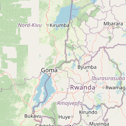
Map view of Ibanda-Kyerwa National Park

Use this park location map to pinpoint Ibanda-Kyerwa National Park in Tanzania, understand its exact geographic position, and read its mapped placement within the surrounding landscape more clearly.

Pigeon | © OpenStreetMap contributors

Location context for Ibanda-Kyerwa National Park

Kagera Region
Park atlas

Map Nearby Protected Areas and Compare Landscapes Across Tanzania's Kagera Region and Bordering Countries

Discover National Parks and Protected Areas Surrounding Ibanda-Kyerwa National Park

Explore national parks and protected areas within Tanzania's Kagera Region and its adjacent borderlands, building on your discovery of Ibanda-Kyerwa National Park. Compare diverse conservation landscapes, trace their geographic spread, and understand the wider network of protected spaces near Uganda and Rwanda.
National parkKagera Region
About 23 km away#1 closest

East

Rumanyika-Karagwe National Park: Protected Landscape and Geographic Context in Kagera Region

Explore the mapped boundaries and regional setting of this national park.

Rumanyika-Karagwe National Park serves as a vital protected landscape within the Kagera Region of Tanzania. This entry facilitates a geographic discovery of the park, highlighting its mapped outlines and its role as a national park. Users can gain an understanding of its regional landscape context, providing a solid foundation for atlas-based exploration and appreciating the park's protected area status.

Area
247 km²
Established
2019
IUCN
II
Climate
Tropical
National parkEastern Province
About 55 km away#2 closest

Southeast

Akagera National Park National Park: Protected Landscape Geography and Atlas Exploration

Understand the mapped terrain and regional context of Akagera National Park.

Akagera National Park, designated as a national park, represents a vital protected landscape within Rwanda's Eastern Province. This atlas-focused entry provides essential geographic context, highlighting the park's mapped boundaries and natural terrain. Explore Akagera National Park as a key element in regional geography and a focal point for understanding protected land distribution.

Area
1,122 km²
Established
1934
Visitors
34K annual
Relief
Mixed relief
National parkKiruhura District
About 76 km away#3 closest

Northeast

Lake Mburo National Park: Uganda's National Park in Kiruhura District

Explore its mapped boundaries and regional geography.

Delve into the protected landscape of Lake Mburo National Park, situated in Uganda's Kiruhura District. This entry provides essential geographic context, mapping its boundaries and regional setting for users interested in detailed atlas exploration of protected areas and natural landscapes.

Area
260 km²
Established
1983
IUCN
II
Relief
Lowland
National parkKanungu District
About 82 km away#4 closest

West

Bwindi Impenetrable National Park: Uganda's National Park Geography and Mapped Terrain

Explore its protected landscape and regional context.

Delve into the protected landscape of Bwindi Impenetrable National Park, a protected area situated within Kanungu District, Uganda. This detail page offers a deep dive into its geographic setting, presenting mapped park boundaries and natural terrain features essential for understanding its role within the regional atlas. Discover the specific environmental context of this national park for robust map-based exploration.

Area
331 km²
Established
1991
IUCN
II
Relief
Mountain
National parkUganda
About 101 km away#5 closest

West

Mgahinga Gorilla National Park: Atlas of Protected Volcanic Landscapes in Uganda

Mapping the Virunga Mountains and high altitude conservation terrain.

Located in southwestern Uganda, Mgahinga Gorilla National Park protects a significant portion of the transboundary Virunga ecosystem. The park encompasses the peaks of Mount Muhabura, Mount Gahinga, and Mount Sabyinyo, providing a unique look at the vertical transition of habitats from bamboo forests to alpine zones. Access detailed geographic data and spatial context for one of the most ecologically important protected areas in the Albertine Rift.

Area
33.9 km²
Established
1991
IUCN
II
Relief
Mountain
National parkKisoro District
About 105 km away#6 closest

West

Mgahinga Gorilla National Park: A Geographic Study of Virunga Mountain Landscapes

Exploring protected boundaries and volcanic terrain in Kisoro District.

Mgahinga Gorilla National Park covers an essential range of montane forest and alpine zones across three dormant volcanoes in the Kisoro District of Uganda. This protected area functions as a key element of the broader Virunga mountain ecosystem, providing specialized habitats for endangered primate populations and endemic bird species. The dramatic vertical relief from bamboo forests to summit peaks defines this critical segment of the Albertine Rift conservation network.

Area
33.9 km²
Established
1991
IUCN
II
Relief
Mountain
Watercolor illustration of rolling hills, mountains, and a river or lake
National parkDemocratic Republic of the Congo
About 109 km away#7 closest

West

Virunga National Park: Democratic Republic of the Congo's Premier Protected Landscape

Mapped boundaries and diverse Albertine Rift endemic geography.

Virunga National Park represents a pivotal protected area within the Democratic Republic of the Congo, characterized by an exceptional range of geographic features and vital ecosystems. Its protected landscape includes active volcanoes like Nyiragongo with its lava lake, the towering Rwenzori Mountains, and diverse lowland savannas. This atlas-focused entry highlights the park's unique position in the Albertine Rift, crucial for numerous endemic species and offering significant insight into regional geography and protected land context.

Area
7,800 km²
Established
1925
IUCN
II
Relief
Mountain
National parkRwanda
About 124 km away#8 closest

West

Volcanoes National Park: Rwanda's Protected Volcanic Landscape and Regional Geography

Mapped park boundaries and East African geographic context.

Delve into Volcanoes National Park, a crucial protected area within Rwanda's northwest. This page offers detailed insight into its geography, highlighting the volcanic terrain and mapped boundaries that define this important national park. Understand its placement within the Virunga Mountains and its contribution to the natural landscape of East Africa, providing a foundation for atlas-based exploration of protected lands.

Area
160 km²
Established
1925
IUCN
II
Relief
Mountain

Common questions about visiting, size, designation, and location context for Ibanda-Kyerwa National Park

Ibanda-Kyerwa National Park FAQs for park facts, access, geography, and protected area context

Find quick answers about Ibanda-Kyerwa National Park, including protected-area facts, park geography, trail and visitor context, and how the park fits into its surrounding country and regional landscape.
MoriAtlas Explorer

Continue Your Protected Areas Search Across the Global Atlas

Deepen your exploration by continuing the structured search for national parks and protected areas worldwide. Utilize the comprehensive filtering capabilities to compare different conservation landscapes and refine your understanding of global park geography. Discover more about the distribution and characteristics of protected natural areas.

Global natural geography


