Mori Atlas logo
National parkLa Gran Sabana National Park

Mapping the protected boundaries and regional geography of this national park.

La Gran Sabana National Park: A Protected Landscape in Independencia Province

La Gran Sabana National Park stands as a significant protected natural area within Independencia Province, offering a unique geographic setting for exploration. This national park is a key component of the region's conservation landscape, providing mapped boundaries and a defined natural terrain. Understanding its place within the broader atlas of protected lands reveals its importance for understanding Dominican Republic's geography and conservation efforts.

Caribbean protected areadry forest ecosystemlowland national parkHoya de EnriquilloDominican Republic parksIUCN Category II

La Gran Sabana National Park

National park

Park overview

Structured park overview, official facts, and landscape profile for La Gran Sabana National Park

La Gran Sabana National Park park facts, protected area profile, and essential visitor context

Review the core facts for La Gran Sabana National Park, including designation, size, terrain, visitor scale, habitats, and operating context in one park-focused overview.

About La Gran Sabana National Park

La Gran Sabana National Park occupies a distinctive position within the Dominican Republic's system of protected areas as a representative example of the island's Caribbean lowland environments. Located in the southwestern portion of the country within the Independencia Province, the park was established in 2009 through official designation as a national park, reflecting the government's recognition of the ecological importance of preserving the Hoya de Enriquillo region's unique characteristics. The park's creation responded to a growing understanding that lowland ecosystems, while less visually dramatic than the mountainous cloud forests found elsewhere in the Dominican Republic, play a critical role in maintaining the nation's overall biodiversity and ecological integrity.

The Hoya de Enriquillo basin represents one of the most significant geological features in the Dominican Republic, encompassing a vast lowland area that experiences notably drier conditions than the rest of the island. This climatic difference has shaped the development of distinctive dry forest communities adapted to seasonal drought and periodic water scarcity. La Gran Sabana National Park provides protection for these ecosystems, ensuring that the biological communities of the lowland zone remain intact for future generations. The park's substantial area of approximately 220 square kilometers provides sufficient space to maintain ecological processes and support viable populations of the species that depend on these habitats.

Quick facts and research context for La Gran Sabana National Park

La Gran Sabana National Park spans approximately 220 square kilometers in the Independencia Province of the Dominican Republic. Established in 2009, it is one of the more recent additions to the country's national park system. The park is located east of Lake Enriquillo within the Hoya de Enriquillo lowland basin, a region known for its semi-arid climate and distinctive Caribbean dry forest ecosystems. The park received its official national park designation in 2009 and is classified under IUCN Category II, reflecting its primary conservation purpose of protecting natural ecosystems.

Protection and recognition

Documenting the official terrestrial designation and management scope within the wider regional network

La Gran Sabana National Park Protection Status and Conservation Geography

Exploring the designated boundaries of La Gran Sabana National Park reveals its formal protection status and structured terrestrial management framework. Official terrestrial records offer vital geographic context for understanding how the park fits into regional conservation frameworks.

Protection details

Protection scope
Terrestrial
Transboundary protection
No
Park context

Deeper park guide and search-rich context for La Gran Sabana National Park

La Gran Sabana National Park history, landscape, wildlife, and travel context

Explore La Gran Sabana National Park through its history, landscape character, ecosystems, wildlife, conservation priorities, cultural context, and seasonal travel timing in a structured park guide built for atlas discovery and search intent.

Why La Gran Sabana National Park stands out

La Gran Sabana National Park is best known for its protection of the Hoya de Enriquillo lowland ecosystem, a landscape type that is underrepresented in the Dominican Republic's protected areas network. The park preserves dry forest and wetland habitats that are characteristic of the Caribbean lowland zone, providing sanctuary for species adapted to the region's semi-arid conditions. Its location adjacent to Lake Enriquillo places it within one of the most geologically significant lowland basins in the Caribbean, a region that stands in sharp topographic contrast to the mountainous terrain that dominates much of the Dominican Republic's interior.

La Gran Sabana National Park history and protected-area timeline

La Gran Sabana National Park was officially designated as a national park in 2009, making it one of the newer protected areas in the Dominican Republic's conservation system. The establishment of the park represented a deliberate expansion of the country's national park network to include representation of the lowland ecosystems found in the Hoya de Enriquillo region. Prior to its designation, the area had been recognized for its ecological significance, and the formal protection granted by national park status reflected both scientific assessments of its biodiversity value and policy decisions aimed at achieving more comprehensive coverage of the Dominican Republic's various habitat types. The 2009 designation placed the park within the framework of the national park system, providing it with the institutional status and regulatory protections appropriate for a Category II protected area under the IUCN classification system.

La Gran Sabana National Park landscape and geographic character

The landscape of La Gran Sabana National Park is defined by its position within the Hoya de Enriquillo lowland basin, a vast area of relatively flat to gently rolling terrain that contrasts sharply with the mountainous interior of the Dominican Republic. The park lies east of Lake Enriquillo, the largest lake in the Caribbean islands and the region's lowest point, which sits at approximately 40 meters below sea level. The broader Hoya de Enriquillo region experiences a semi-arid climate that distinguishes it from the more tropical conditions found in other parts of the Dominican Republic. The terrain within the park consists primarily of lowland terrain with vegetation adapted to seasonal dryness, creating a landscape of dry forests, scrubland, and transitional wetland areas that reflect the basin's distinctive environmental conditions.

La Gran Sabana National Park ecosystems, habitats, and plant life

The ecological character of La Gran Sabana National Park centers on dry tropical forest ecosystems that have adapted to the semi-arid conditions of the Hoya de Enriquillo lowland. These forests differ significantly from the humid and cloud forest communities found in the Dominican Republic's higher elevations, hosting a distinct assemblage of plant and animal species adapted to seasonal drought and higher temperatures. The lowland setting creates environmental conditions that support specialized dry-adapted vegetation communities, including drought-resistant trees and shrubs that can survive the extended dry periods characteristic of this region. The proximity to Lake Enriquillo influences the park's ecological character through the presence of wetland habitats and riparian zones that provide additional habitat diversity within the broader dry forest matrix.

La Gran Sabana National Park wildlife and species highlights

The wildlife of La Gran Sabana National Park reflects the distinctive dry forest ecosystem of the Hoya de Enriquillo lowland. Species adapted to semi-arid conditions dominate the park's fauna, including numerous bird species that have evolved to exploit dry forest habitats, reptiles tolerant of higher temperatures and more variable moisture conditions, and invertebrates specifically adapted to the leaf-litter and soil environments of tropical dry forests. The broader Hoya de Enriquillo region supports populations of regionally significant species, and the protected status of the park provides important habitat for maintaining these populations within a landscape that faces ongoing pressures from agricultural expansion and development.

La Gran Sabana National Park conservation status and protection priorities

La Gran Sabana National Park contributes to the Dominican Republic's conservation goals by protecting a habitat type that was previously underrepresented in the national park system. The park's designation in 2009 as a Category II protected area reflects an explicit conservation purpose focused on maintaining the integrity of the Hoya de Enriquillo's lowland ecosystems. This protection addresses a gap in the country's protected areas network, which historically has emphasized higher-elevation forests and mountain environments. The park's substantial area provides sufficient habitat to support viable ecological communities and maintain the ecological processes essential for the long-term persistence of the dry forest ecosystem. Conservation of this lowland zone also contributes to the broader protection of watersheds and the maintenance of ecological connectivity across the southwestern Dominican Republic.

La Gran Sabana National Park cultural meaning and human context

La Gran Sabana National Park is situated within the Hoya de Enriquillo region, an area that has been inhabited by human communities for centuries. The broader region contains evidence of pre-Columbian occupation and has been shaped by agricultural and pastoral activities over the colonial and post-colonial periods. While the park itself is primarily focused on natural ecosystem protection, the cultural landscape surrounding the protected area reflects the long history of human interaction with the lowland environment. Local communities in the Independencia Province maintain connections to the land and resources of the region, and the park's management must consider the social context of the surrounding landscape while fulfilling its primary conservation mandate.

Top sights and standout views in La Gran Sabana National Park

La Gran Sabana National Park offers distinctive lowland protection within the Dominican Republic's protected areas system, preserving the semi-arid Caribbean ecosystems of the Hoya de Enriquillo basin. The park provides access to dry forest habitats that differ markedly from the humid and cloud forest environments more commonly associated with Dominican Republic conservation areas. Its location adjacent to the Lake Enriquillo basin places it within one of the Caribbean's most significant lowland wetland complexes, creating opportunities for appreciating the ecological connections between forest and aquatic environments. The park represents a deliberate conservation investment in protecting the island's lowland biodiversity and the ecosystem services these habitats provide.

Best time to visit La Gran Sabana National Park

The optimal time to visit La Gran Sabana National Park aligns with the cooler, drier months typically occurring from November through April, when temperatures are more comfortable for outdoor exploration and wildlife activity patterns may be more predictable. The dry season generally provides easier access to trail systems and more favorable conditions for observing dry forest wildlife, though visitors should be prepared for the characteristic semi-arid conditions of the Hoya de Enriquillo region throughout the year. The wet season, from May through October, brings higher temperatures and periodic rainfall that can affect trail conditions and accessibility, though this period also supports increased vegetation density and different wildlife viewing opportunities.

Monthly climate preview

Long-term temperature patterns and precipitation trends in Independencia Province

La Gran Sabana National Park Climate and Monthly Weather Normals

Long-term meteorological records at a representative park elevation of 415 meters show warm average temperatures ranging from 23 to 27 degrees Celsius alongside shifting daily precipitation averages throughout the year. Analyzing the complete twelve-month cycle reveals detailed monthly minimums, maximums, and daily rainfall rates essential for understanding the broader regional climate.
Annual mean26 °C
24 °C27 °C
Jan24°
Feb24°
Mar25°
Apr26°
May26°
Jun26°
Jul27°
Aug27°
Sep27°
Oct26°
Nov25°
Dec24°
Warmest month
August

27 °C

Coolest month
January

23.7 °C

Wettest month
October

2 mm/day

Driest month
February

0.6 mm/day

Park location guide

Geography guide, regional context, and park location map for La Gran Sabana National Park

La Gran Sabana National Park park geography, regions, and map view in Dominican Republic

Understand where La Gran Sabana National Park sits in Dominican Republic through a broader geographic reading of the surrounding landscape, nearby location context, and its mapped position within the national park landscape.

How La Gran Sabana National Park fits into Dominican Republic

The Dominican Republic is a presidential republic on Hispaniola island in the Caribbean. It occupies the eastern portion of the island, sharing the western part with Haiti. The country has a population of approximately 11.5 million and is known for its colonial history, beaches, and mountainous interior. Santo Domingo is the capital and largest city.

Wider geography shaping La Gran Sabana National Park in Dominican Republic

The Dominican Republic occupies the eastern five-eighths of Hispaniola island in the Greater Antilles, bordered by the Caribbean Sea. It shares a land border with Haiti to the west and has maritime boundaries with Puerto Rico to the east. The terrain features mountainous interior ranges, fertile valleys, and coastal plains. The country is second in size among Caribbean nations after Cuba.

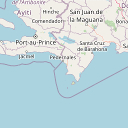
Map view of La Gran Sabana National Park

Use this park location map to pinpoint La Gran Sabana National Park in Dominican Republic, understand its exact geographic position, and read its mapped placement within the surrounding landscape more clearly.

Pigeon | © OpenStreetMap contributors

Location context for La Gran Sabana National Park

Independencia Province
Park atlas

Trace the regional geography of the Hoya de Enriquillo basin and other unique conservation landscapes across the Dominican Republic.

Explore Other National Parks and Protected Areas Near La Gran Sabana National Park

After exploring La Gran Sabana National Park's distinctive lowland ecosystems and dry forest habitats, browse a curated list of additional protected areas across the Dominican Republic. Compare these mapped conservation landscapes to understand the broader spread of Caribbean protected areas and their varied geographical contexts on the island.
National parkPedernales Province
About 45 km away#1 closest

South

Jaragua National Park: Dominican Republic National Park Protected Landscape Atlas

Discover the mapped geography and protected boundaries of Jaragua National Park.

Jaragua National Park stands as a crucial national park within the Dominican Republic, located in Pedernales Province. This entry provides an in-depth, atlas-style examination of the park's protected landscape, focusing on its geographic features and mapped extent. Users can explore the park's position within the regional geography and understand its significance as a conservation area.

Area
1,374 km²
Established
1983
IUCN
II
Relief
Mountain
National parkSud Department
About 63 km away#2 closest

West

Forêt des Pins National Park: Geographic Overview of Haiti's Highland Protected Landscapes

Mapping the pine-forested terrain and high-altitude mountain ecosystems of the southern massif.

Explore the expansive geography of Forêt des Pins National Park, which protects the remnants of Haiti's highland Caribbean pine forests. This protected area spans critical high-elevation slopes and mountain watersheds, offering a detailed look at the rugged natural terrain of the southern massif surrounding Pic la Selle.

Area
187.8 km²
Established
1937
National parkHaiti
About 64 km away#3 closest

West

Parc national La Visite: Atlas and Geographic Overview of Haiti Protected Highlands

Highland pine forest refuges and karst limestone landscapes.

Located in the Chaîne de la Selle, Parc national La Visite serves as a key conservation anchor for the unique upland ecosystems of Haiti. This detailed atlas entry maps the park's steep limestone plateaus, deep gorges, and expansive pine forests, providing essential context on one of the Caribbean's most significant transboundary protected mountain landscapes.

Established
1983
National parkDominican Republic
About 71 km away#4 closest

Northeast

Valle Nuevo National Park: Nearctic Highland Ecosystem and Glacial Landscapes

Mapped protected area in the Dominican Republic's Cordillera Central.

Valle Nuevo National Park in the Dominican Republic offers a rare glimpse into a Nearctic ecosystem within the Caribbean. Spanning 910 square kilometers in the Cordillera Central, it features dramatic mountain peaks like Loma Alto de la Bandera and distinctive glacial landforms. The park protects extensive Hispaniolan pine forests and cloud forest habitats, supporting remarkable endemic biodiversity and serving as a critical watershed for the region.

Area
910 km²
Established
1996
IUCN
II
Relief
Mountain
National parkDominican Republic
About 78 km away#5 closest

North

José Armando Bermúdez National Park: Dominican Republic National Park Atlas and Landscape Context

Discover the mapped protected area and geographic setting of this Dominican Republic national park.

Gain an understanding of José Armando Bermúdez National Park as a distinct protected landscape within the Dominican Republic. This entry focuses on its role as a national park, providing geographic context and highlighting its mapped boundaries for atlas exploration. Explore the park's specific terrain and its place within the nation's conservation network.

Area
766 km²
Established
1956
IUCN
II
Relief
Mountain
National parkHaiti
About 100 km away#6 closest

West

La Visite National Park: Protected Highland Terrain and Endemic Pine Forest Landscape

Explore the geography and mapped park boundaries of Haiti's significant national park.

La Visite National Park is a vital protected area located in Haiti's mountainous Massif de la Selle region. It is distinguished by its rare montane ecosystems, including extensive Hispaniolan pine forests and high-altitude grasslands, creating a unique landscape within the Caribbean. This atlas entry focuses on the park's geographic setting, its mapped protected boundaries, and its ecological significance as a key component of Haiti's natural heritage, offering a detailed look at its distinctive terrain.

Area
30 km²
Established
1983
IUCN
II
Relief
Mountain
National parkHaiti
About 100 km away#7 closest

West

Parc national La Visite: Protected Highland Plateau and Pine Forest Geography in Haiti

Mapping the Massif de la Selle mountain ecosystems.

Parc national La Visite occupies a critical position in southeastern Haiti, protecting a rugged highland plateau defined by dense ravines and Haiti's largest surviving pine forest. This protected area offers a distinct geographic window into the cool, montane terrain of the Massif de la Selle, serving as an essential core zone for regional conservation and mountain landscape study.

Area
30 km²
Established
1983
IUCN
II
National parkDominican Republic
About 133 km away#8 closest

Northeast

Pueblo Viejo National Park: Dominican Republic Colonial Ruins and Gold Mining Heritage

Explore early Caribbean colonization and its archaeological landscape.

Pueblo Viejo National Park stands as a crucial archaeological site in the Dominican Republic, preserving the remnants of Concepción de la Vega, a significant colonial settlement established during the era of Christopher Columbus. This national park offers a unique window into the beginnings of European presence and the first major gold extraction operations in the Americas. Examine the mapped foundations of its fortress and town structures, understanding the colonial urban planning and the historical geography of early Caribbean heritage.

IUCN
II
Access
Easy access
Scope
Terrestrial
Water
No major water

Common questions about visiting, size, designation, and location context for La Gran Sabana National Park

La Gran Sabana National Park FAQs for park facts, access, geography, and protected area context

Find quick answers about La Gran Sabana National Park, including protected-area facts, park geography, trail and visitor context, and how the park fits into its surrounding country and regional landscape.
MoriAtlas Explorer

Continue Your Protected Areas Search Across the Global Atlas

Deepen your exploration by continuing the structured search for national parks and protected areas worldwide. Utilize the comprehensive filtering capabilities to compare different conservation landscapes and refine your understanding of global park geography. Discover more about the distribution and characteristics of protected natural areas.

Global natural geography