Mori Atlas logo
Nature reserveTeberda Nature Reserve

Navigate the geographic contours and protected boundaries of this significant nature reserve.

Teberda Nature Reserve: A Protected Landscape Within the Karachay-Cherkess Republic

(Teberdinsky Nature Reserve)

Teberda Nature Reserve stands as a vital protected landscape within the mountainous terrain of the Karachay-Cherkess Republic. This page offers a detailed atlas-view of the reserve, highlighting its geographic position and mapped boundaries. Understand Teberda Nature Reserve's role as a protected natural area and its contribution to the regional geography for structured landscape discovery.

Strict Nature ReserveCaucasus MountainsAlpine EcosystemsGlacial LandscapeEndemic SpeciesBiosphere Reserve
Illustration of green mountains, blue river, and pine trees under a colorful sky

Teberda Nature Reserve

Nature reserve

Park overview

Structured park overview, official facts, and landscape profile for Teberda Nature Reserve

Teberda Nature Reserve park facts, protected area profile, and essential visitor context
Review the core facts for Teberda Nature Reserve, including designation, size, terrain, visitor scale, habitats, and operating context in one park-focused overview.

About Teberda Nature Reserve

Teberda Nature Reserve represents one of Russia's most important protected areas, established in 1936 to preserve the unique ecosystems of the western Caucasus Mountains. Located within the Karachayevsky District of the Karachay-Cherkess Republic, the reserve spans approximately 85,000 hectares across two distinct sections separated by the Main Caucasus ridge. The eastern Tebardinsky sector encompasses the headwaters of the Teberda River, while the western Arkhyz section follows the Kyzgych River valley. In 2010, these two areas were connected through a biosphere polygon linked to the broader Caucasus State Nature Reserve, creating a larger protected landscape. The reserve's popularity as Russia's most visited nature reserve stems from its combination of strict conservation zones, which remain closed to the general public, and carefully managed ecotourism corridors that allow visitors to experience the reserve's natural wonders. The extensive tourist infrastructure near the Dombay entrance provides facilities while maintaining the reserve's conservation integrity. The landscape reflects its geological history, with mountains formed by tectonic forces and valleys carved by two major periods of glaciation during the Jurassic and more recent epochs.

Quick facts and research context for Teberda Nature Reserve

Teberda Nature Reserve occupies the western Caucasus Mountains in the Karachay-Cherkess Republic of southern Russia, near the village of Teberda. The reserve covers 84,996 hectares across two main sectors: the larger Tebardinsky section to the east and the Arkhyz section to the west. Altitudes range from 1,260 meters in the river valleys to 4,047 meters at the highest peaks, with notable summits including Dombay-Ulgen, Boo-Ulgen, and Dzhalovchat. The landscape features 109 glaciers covering 74.3 square kilometers and 157 lakes concentrated above 2,000 meters. The reserve holds IUCN Category Ia status as a strict nature reserve and is integrated into the Caucasus State Nature Reserve biosphere polygon established in 2010. The region experiences a humid continental climate with cool summers and long cold winters.

Park context

Deeper park guide and search-rich context for Teberda Nature Reserve

Teberda Nature Reserve history, landscape, wildlife, and travel context
Explore Teberda Nature Reserve through its history, landscape character, ecosystems, wildlife, conservation priorities, cultural context, and seasonal travel timing in a structured park guide built for atlas discovery and search intent.

Why Teberda Nature Reserve stands out

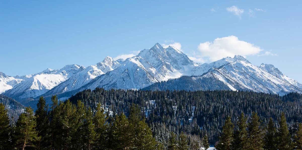
Teberda is best known for its exceptional alpine landscapes and biodiversity within the Caucasus Mountains, one of the world's most significant centers of plant and animal endemism. The reserve protects critical populations of the Caucasian ibex, a mountain ungulate renowned for its impressive saber horns that can reach one meter in length on mature males. The near-threatened Caucasian black grouse, a bird species endemic to the Caucasus region, makes its home in the reserve's coniferous forests and alpine meadows. The dramatic glaciated peaks, including the iconic Dombay mountain, create a spectacular high-altitude environment where 109 glaciers descend into tight mountain valleys. The reserve also preserves successful conservation stories, including the reintroduction of European bison to the region after their local extermination in 1926.

Snow-covered mountain peaks with a dense coniferous forest in the foreground under a clear blue sky
Snow-capped mountain peaks above a dense forest in Teberda Nature Reserve

Teberda Nature Reserve history and protected-area timeline

Teberda Nature Reserve was established in 1936 as part of the Soviet Union's network of zapovedniks, strict nature reserves designed to preserve representative ecosystems and scientific biodiversity. The reserve was created to protect the exceptional natural landscapes and endemic species of the western Caucasus, a region recognized for its remarkable biological diversity. Initially covering the Tebardinsky section, the reserve was later expanded to include the Arkhyz sector, creating the two-component structure that exists today. A significant development occurred in 2010 when the two sections were connected through the establishment of a biosphere polygon linking Teberda with the Caucasus State Nature Reserve, forming a larger conservation landscape. The reserve has also played a critical role in wildlife recovery, particularly with the reintroduction of European bison (wisent) after the species was exterminated in the region in 1926. As of 2015, the reserve's wild bison population had grown to 32 individuals. The reserve operates under the management of Russia's Ministry of Natural Resources and Environment, maintaining its strict protection status while accommodating managed ecotourism.

Teberda Nature Reserve landscape and geographic character

The landscape of Teberda Nature Reserve is defined by the dramatic terrain of the western Caucasus Mountains, where tectonic forces created rugged peaks and glacial valleys that descend from elevations exceeding 4,000 meters down to forest-covered slopes at around 1,260 meters. The southern border follows the Main Caucasus ridge between the Klukhori and Herzog peaks, while the two main sections occupy distinct river valleys: the Tebardinsky sector follows the Teberda River headwaters in the east, and the Arkhyz section follows the Kyzgych River valley in the west. The terrain is characterized by extreme variation, with approximately 38.4% covered in rock and scree, 31.7% in forests, 20% in meadows, and 8.5% in glaciers. The reserve contains 109 glaciers with a combined area of 74.3 square kilometers, along with extensive snowfields that feed steep mountain streams forming powerful rapids and waterfalls. There are 157 lakes on the reserve, most situated above 2,000 meters with maximum depths of 30 to 50 meters. The highest peaks include Dombay-Ulgen at 4,042 meters, Boo-Ulgen at 3,915 meters, Dzhalovchat at 3,870 meters, and Bela Kaya at 3,861 meters, creating an impressive alpine skyline.

Teberda Nature Reserve ecosystems, habitats, and plant life

Teberda Nature Reserve lies within the Caucasus mixed forests ecoregion, one of the world's most significant biodiversity hotspots situated between the Black Sea and Caspian Sea. The reserve exhibits remarkable altitude zoning that creates five distinct ecological bands: forest zone, sub-alpine zone between 2,000 and 2,500 meters, alpine zone between 2,500 and 3,000 meters, sub-nival zone, and the nival zone of permanent snow and rock. The forest zone, covering approximately 34% of the reserve, is dominated by pine forests with an understory of juniper and rhododendron. The southern areas feature coniferous forest, while the lower floodplains of the Teberda River contain distinctive stands of alder. The alpine zones support characteristic heath communities and meadows adapted to harsh high-altitude conditions. The ecoregion's global significance is underscored by exceptional endemism rates: 23% of vascular plant species and 10% of vertebrate species are found nowhere else on Earth, making the Caucasus one of the highest-biodiversity mountainous regions globally.

Teberda Nature Reserve wildlife and species highlights

The wildlife of Teberda Nature Reserve reflects the exceptional biodiversity of the Caucasus Mountains, with 46 mammal species and 226 bird species recorded within its boundaries. The reserve supports a significant population of Caucasian ibex, with an estimated 1,300 to 1,600 individuals, a species distinguished by the large saber horns that can reach one meter in length on mature males. European bison have been successfully reintroduced to the reserve after local extinction in 1926, with the population growing to 32 individuals by 2015, representing an important conservation success. The reserve provides crucial habitat for the Caucasian black grouse, a near-threatened bird species that is endemic to the Caucasus region and serves as a symbol of the region's unique avifauna. Other notable wildlife includes the recently expanded jackal population, which has become the most common predator in the reserve. The streams support three fish species: brown trout, common minnow, and European loach. The diversity of habitats from forest through sub-alpine and alpine zones supports this rich faunal community.

Teberda Nature Reserve conservation status and protection priorities

Teberda Nature Reserve holds IUCN Category Ia status as a strict nature reserve, representing the highest level of protection within the international protected area classification system. The reserve is an integral component of a UNESCO World Biosphere Reserve, recognizing its dual role in biodiversity conservation and sustainable use. The 2010 establishment of the biosphere polygon connecting Teberda with the broader Caucasus State Nature Reserve created a larger conservation landscape that facilitates ecological connectivity across the western Caucasus. The reserve protects one of the world's most significant centers of endemism, with the Caucasus Mountains hosting 23% endemic vascular plant species and 10% endemic vertebrates. Conservation efforts have focused on protecting core habitat areas with strict access restrictions while maintaining carefully managed ecotourism routes that allow controlled visitor access without compromising ecological integrity. The successful bison reintroduction program demonstrates the reserve's capacity for active species recovery, while ongoing monitoring supports management decisions for the diverse flora and fauna dependent on this mountainous protected area.

Teberda Nature Reserve cultural meaning and human context

Teberda Nature Reserve is located within the Karachay-Cherkess Republic, a region in southern Russia with a complex ethnic history and diverse cultural heritage. The reserve takes its name from the Teberda River and the nearby settlement of Teberda, which has developed as a gateway community for visitors accessing the reserve and surrounding resort areas. The Dombay tourist complex at the reserve's entrance represents the long-standing relationship between human settlement and the mountain environment, providing visitor infrastructure while the reserve maintains its strict protection status. The region's history involves the indigenous peoples of the Caucasus, including Turkic and Circassian groups whose traditional land use practices shaped the cultural landscape before Soviet-era protected area establishment. While the reserve itself operates under strict protection protocols, the surrounding Karachay-Cherkess Republic maintains strong connections to the mountain environments that define the region's identity and continue to support local communities and traditional land use patterns outside the core protected zones.

Top sights and standout views in Teberda Nature Reserve

Teberda Nature Reserve stands out as Russia's most visited nature reserve, offering access to some of the most spectacular alpine landscapes in the Caucasus Mountains while maintaining strict conservation through its IUCN Category Ia status. The reserve protects critical populations of endemic species including the Caucasian ibex with its impressive curved horns and the near-threatened Caucasian black grouse, a bird found nowhere else on Earth. The dramatic glaciated peaks, including the iconic Dombay-Ulgen at over 4,000 meters, create a stunning backdrop for visitors accessing the reserve's carefully managed ecotourism routes. The successful reintroduction of European bison represents an important conservation achievement, demonstrating the reserve's commitment to species recovery. The integration into a larger UNESCO World Biosphere Reserve connected through the Caucasus State Nature Reserve polygon ensures landscape-level conservation that extends protection beyond the reserve's core boundaries.

Best time to visit Teberda Nature Reserve

Teberda Nature Reserve can be visited year-round, though the most popular season occurs during the summer months when the weather is most stable and the alpine meadows display their full floral diversity. The reserve's humid continental climate brings cool summers with average July temperatures of 15.5°C, making it a refreshing escape from lowland heat. Winter visits offer the opportunity to experience the dramatic winter mountain landscape, though access to higher-elevation routes is limited by snow cover that typically lasts from 21 to 122 days annually. The shoulder seasons of spring and autumn provide different experiences, with spring bringing snowmelt and waterfall flows at their peak, while autumn showcases the sub-alpine and forest zones in fall coloration. The average frost-free period of 126 days guides the practical visitor season, with the reserve's tourist infrastructure at Dombay providing access and permits for the various ecotourism routes throughout the accessible periods.

Park location guide

Geography guide, regional context, and park location map for Teberda Nature Reserve

Teberda Nature Reserve park geography, regions, and map view in Russia
Understand where Teberda Nature Reserve sits in Russia through a broader geographic reading of the surrounding landscape, nearby location context, and its mapped position within the national park landscape.

How Teberda Nature Reserve fits into Russia

Russia is a transcontinental nation spanning eleven time zones, bordered by fourteen countries. It is the world's largest country by area, covering 17,098,246 km². Moscow is the capital and largest city, while Saint Petersburg is the second-largest and a major cultural centre.

Wider geography shaping Teberda Nature Reserve in Russia

Russia spans Eastern Europe and North Asia, covering 17,098,246 km². It shares land borders with fourteen countries, more than any other nation, and spans eleven time zones. The landscape includes vast plains, mountain ranges such as the Urals and Caucasus, and extensive coastlines along the Arctic Ocean, Pacific Ocean, Baltic Sea, Black Sea, and Caspian Sea.

Map view of Teberda Nature Reserve

Use this park location map to pinpoint Teberda Nature Reserve in Russia, understand its exact geographic position, and read its mapped placement within the surrounding landscape more clearly.

Pigeon | © OpenStreetMap contributors

Location context for Teberda Nature Reserve

Karachay-Cherkess Republic

Discover the breathtaking Caucasus Mountain terrain, diverse habitats, and protected alpine environment of Teberda through stunning park imagery.

Visual Guide to Teberda Nature Reserve: Explore Alpine Landscapes, Glacial Valleys, and Mountain Scenery
Explore a curated collection of imagery capturing Teberda Nature Reserve's dramatic alpine landscapes, showcasing its glacier-carved valleys, high-altitude lakes, and rugged Caucasus Mountain peaks. Visualizing the reserve's unique terrain, diverse habitats, and protected environment through these photographs is essential for understanding its distinct ecological character and conservation significance.

Snow-covered mountain peaks with a dense coniferous forest in the foreground under a clear blue sky

Rugged mountains with patches of snow, green valleys, and a partly cloudy sky

Park atlas

Compare adjacent protected landscapes in the Western Caucasus Mountains and surrounding Russian regions

Explore Other National Parks and Protected Areas Near Teberda Nature Reserve
Browse a curated list of national parks and protected areas located near Teberda Nature Reserve, extending your geographic discovery across the Western Caucasus Mountains region. This atlas view helps compare diverse alpine ecosystems, glacial terrain, and significant biodiversity, providing essential regional context for protected-area exploration.
Watercolor painting of mountains, lake, and forest landscape with greenery and distant peaks
National parkKabardino-Balkaria

Prielbrusye National Park: Mapped Protected Landscape within Kabardino-Balkaria's Geography

Explore regional park boundaries and natural terrain context.

Prielbrusye National Park is a significant protected area featured in the MoriAtlas geographic discovery platform. This page details its identity as a national park, emphasizing its mapped boundaries and its position within the broader landscape of Kabardino-Balkaria. Users can explore the park's unique geographic context, understand its protected status, and integrate its information into a larger atlas-based understanding of regional natural territories.

Area
10,102 km²
Established
1986
IUCN
II
Relief
Mountain
National park

Kislovodsk National Park: A Russian National Park Defined by Protected Landscape and Geography

Explore its mapped terrain and regional natural context.

Kislovodsk National Park represents a significant protected landscape within the Russian Federation, recognized as a national park. This MoriAtlas entry focuses on its distinct geographic identity and the character of its protected territory. Discover its mapped boundaries, understand its relationship to the surrounding regional geography, and gain context for its natural landscape within a structured atlas framework. This provides a foundation for exploring its place in the broader map of protected areas.

Area
10 km²
Established
2016
IUCN
II
National parkGeorgia

Kolkheti National Park: Mapped Wetland Landscape & Protected Area in Georgia

Explore the peat bogs, coastal ecosystems, and bird migration routes.

Discover Kolkheti National Park, a key protected national park located in Georgia's western coastal region. This atlas entry focuses on the park's extensive wetland environments, including its significant peat bogs and Lake Paliastomi, highlighting its role as a critical migratory bird corridor and a unique natural landscape within the Black Sea region. Understand its geographic context and protected area boundaries.

Area
807.99 km²
Established
1998
IUCN
II
Visitors
13.7K annual
National parkNorth Ossetia-Alania

Alaniya National Park: Protected Glacial Mountain Landscape in North Ossetia-Alania, Russia

Explore dramatic terrain and ancient heritage.

Alaniya National Park, situated in the rugged Central Caucasus Mountains of North Ossetia-Alania, Russia, is a premier example of a protected landscape defined by its dramatic glacial formations and high alpine environments. The park's geography features extensive glaciated peaks, deep valleys, and unique biodiversity. It preserves critical habitats and showcases significant archaeological sites, providing a rich context for understanding the natural and cultural history of the region through a structured atlas perspective.

Area
549 km²
Established
1998
IUCN
II
Relief
Mountain
Watercolor illustration of a landscape with green hills, trees, and a body of water
National parkAdjara

Mtirala National Park: Protected Colchic Rainforest Landscape & Geographic Atlas

Explore Adjara's unique terrain and mapped protected boundaries.

Mtirala National Park, located in Georgia's Adjara region, is a protected national park renowned for its exceptionally high rainfall and ancient Colchic relict forests. This atlas-focused profile details the park's unique topography, its watershed between the Chakvistskali and Khoristskali rivers, and its significance as a vital ecosystem. Understand the geographic context of this protected landscape and its role in the broader Caucasus geography.

Area
281.26 km²
Established
2006
IUCN
II
Relief
Mixed relief
Watercolor illustration of a landscape with rolling hills, forests, and a winding river.
National parkAdjara

Kintrishi National Park: Protected Colchic Forest Canyon Landscape in Adjara

Explore the mapped geographic boundaries of this unique Georgian national park.

Kintrishi National Park, located in Georgia's Adjara region, is a protected landscape renowned for its exceptionally intact Colchic deciduous forests within a steep river gorge. This area showcases dense woodland, dramatic terrain, and the unique Colchican willow species, offering rich geographic context. As a key protected area, Kintrishi National Park provides a valuable focus for atlas-based exploration of southwestern Georgia's natural heritage.

Area
186.84 km²
Established
2007
IUCN
II
Scope
Terrestrial
National parkAdjara

Machakhela National Park: Adjara's Colchic Forest Protected Landscape

Explore Georgia's unique Caucasus mountain geography and mapped park boundaries.

Machakhela National Park represents a crucial protected area in Georgia's Adjara region, safeguarding the integrity of ancient Colchic broadleaf forests. This park's landscape is characterized by the steep Machakhelistsqali River valley, carved into the lower Caucasus mountains, offering a distinct geographic profile for atlas exploration. Discover the park's specific terrain, mapped boundaries, and its ecological significance as a vital component of the regional natural heritage.

Area
130.7 km²
Established
2012
IUCN
II
Relief
Mixed relief
National parkGeorgia

Borjomi-Kharagauli National Park: Protected Landscape Atlas of Georgia's Lesser Caucasus

Explore its unique forests, wildlife, and mountain terrain.

Delve into Borjomi-Kharagauli National Park, a significant protected area in Georgia's Lesser Caucasus region. This national park is renowned for its extensive old-growth forests, including rare Colchian fragments, and a remarkable concentration of endemic species. The park's dramatic mountainous terrain, spanning over 1,000 square kilometers, offers a rich tapestry of landscapes from deep valleys to alpine meadows, providing critical habitat for large mammals and contributing significantly to the region's biodiversity. Explore its mapped boundaries and geographic context for a deeper understanding of this vital conservation landscape.

Area
1,093 km²
Established
1995
IUCN
II
Relief
Mountain

Common questions about visiting, size, designation, and location context for Teberda Nature Reserve

Teberda Nature Reserve FAQs for park facts, access, geography, and protected area context
Find quick answers about Teberda Nature Reserve, including protected-area facts, park geography, trail and visitor context, and how the park fits into its surrounding country and regional landscape.
MoriAtlas Explorer

Continue Your Protected Areas Search Across the Global Atlas

Deepen your exploration by continuing the structured search for national parks and protected areas worldwide. Utilize the comprehensive filtering capabilities to compare different conservation landscapes and refine your understanding of global park geography. Discover more about the distribution and characteristics of protected natural areas.

Global natural geography