Mori Atlas logo
National parkAkanda National Park

Discover the vast mangrove ecosystems and migratory bird havens of this critical West African protected area.

Akanda National Park: Gabon's Premier Coastal Protected Landscape and Mangrove Atlas

(Parc National d'Akanda)

Akanda National Park, situated in northwestern Gabon just north of Libreville, represents a significant protected landscape on the Atlantic coast. This National Park encompasses approximately 540 square kilometers of unique mangrove forests and tidal beach habitats, establishing one of Africa's most important mangrove complexes. As part of Gabon's national park system, Akanda offers a crucial window into the region's coastal biodiversity, serving as a vital habitat for migratory birds and supporting marine life within its mapped boundaries.

Mangrove forestsCoastal wetlandsMigratory birdsMarine conservationRamsar siteImportant Bird Area

Akanda National Park

National park

Park overview

Structured park overview, official facts, and landscape profile for Akanda National Park

Akanda National Park park facts, protected area profile, and essential visitor context

Review the core facts for Akanda National Park, including designation, size, terrain, visitor scale, habitats, and operating context in one park-focused overview.

About Akanda National Park

Akanda National Park represents a critical component of Gabon's coastal conservation network, protecting a stretch of shoreline and associated wetlands just north of Libreville that might otherwise have been lost to development pressure. The park's mangrove forests are not merely scenic assets but functional ecosystems that buffer the coast against erosion, filter water, and provide nursery habitat for fish and crustaceans. These mangroves are part of a larger coastal complex that includes the adjacent Pongara National Park, and together these protected areas contain about a quarter of all protected mangrove habitat in Africa, a remarkable concentration given Gabon's relatively small share of continental mangrove area. The park's designation as a Ramsar Wetland in 2007 acknowledged its international significance as a coastal wetland ecosystem, while its Important Bird Area status recognizes the critical role it plays in supporting migratory bird populations. The proximity to Libreville presents both opportunities and challenges for the park, as it is accessible for tourism and environmental education while facing pressure from urban expansion and agricultural encroachment.

Quick facts and research context for Akanda National Park

Akanda National Park lies in northwestern Gabon near Libreville, covering roughly 540 square kilometers of primarily mangrove and tidal zone ecosystems. The park was established in 2002 under Gabon's national park initiative and holds IUCN Category II protection status. It was designated as a Ramsar Wetland in 2007, recognizing its international importance as a coastal wetland habitat. Together with adjacent Pongara National Park, Akanda protects approximately 25 percent of Africa's total protected mangrove area, despite Gabon accounting for only 2.5 percent of the continent's mangrove swamps. The park serves as Gabon's most important site for migratory birds and has been recognized as an Important Bird Area by BirdLife International.

Protection and recognition

Documenting the official conservation framework, establishment date, and Ramsar wetland status.

Akanda National Park Protection Status and Ramsar Designation

Mapped records outline the official protection status of Akanda National Park, tracking its establishment in 2007 along with its mixed conservation management scope. Users can explore verified designation data and international recognition history, including the park's formal status as a registered Ramsar wetland site.

International recognition

Protection details

Protection scope
Mixed
Designated year
2007
Transboundary protection
No
Park context

Deeper park guide and search-rich context for Akanda National Park

Akanda National Park history, landscape, wildlife, and travel context

Explore Akanda National Park through its history, landscape character, ecosystems, wildlife, conservation priorities, cultural context, and seasonal travel timing in a structured park guide built for atlas discovery and search intent.

Why Akanda National Park stands out

Akanda National Park is best known for its extensive mangrove ecosystems, which form one of the most significant protected mangrove complexes in Africa. The park serves as the primary site for migratory birds in Gabon, hosting the largest populations of migratory bird species in the country. The coastal waters of Mondah and Corisco bays within the park boundary support rich marine life, including turtles that use Corisco Bay as an important feeding area. The combination of mangrove forests, tidal beaches, and productive marine environments creates a vital coastal protection zone that helps stabilize the shoreline around Libreville.

Akanda National Park history and protected-area timeline

Akanda National Park was established in 2002 as part of a landmark initiative by Gabon's President Omar Bongo to create a comprehensive network of national parks across the country. The establishment followed a two-year study conducted jointly by the Directorate of Wildlife and Hunting, the Wildlife Conservation Society, and the World Wide Fund for Nature, which identified the key ecosystems requiring protection to represent Gabon's biodiversity. This initiative resulted in the creation of thirteen national parks designed to showcase the full range of Gabon's ecological diversity, from coastal mangroves to inland rainforests. Akanda was one of the parks selected to represent the country's coastal and marine environments. In 2007, the park received additional recognition through its designation as a Ramsar Wetland, placing it within the international framework of protected wetlands of importance.

Akanda National Park landscape and geographic character

The landscape of Akanda National Park is defined by the interface between terrestrial mangrove forests and the marine environment of the Atlantic coast. The park encompasses tidal beach zones that extend along the shoreline, with mangrove swamps occupying the low-lying areas between the coast and the mainland. The terrain is generally flat and low-lying, characteristic of coastal wetland environments. Two significant bays, Mondah Bay and Corisco Bay, indent the coastline within the park's boundaries, providing sheltered marine areas that support diverse ecosystems. The mangrove vegetation creates a distinctive visual landscape of dense, interlocking trees with extensive root systems that are partially submerged at high tide, transitioning to mudflats and sand beaches as the tidal cycle progresses.

Akanda National Park ecosystems, habitats, and plant life

The ecological character of Akanda National Park centers on its mangrove-dominated coastal wetlands, which represent one of Africa's most significant protected mangrove complexes despite Gabon's relatively small total mangrove area on the continent. These mangrove forests serve as highly productive ecosystems that support complex food webs and provide essential services including coastal protection, water filtration, and carbon storage. The tidal beaches and shallow bay waters complement the mangrove habitats, creating a continuum of coastal ecosystems that supports both marine and terrestrial species. The park's international importance for migratory birds stems from its position along the East Atlantic Flyway, where it provides critical staging and wintering habitat for species that breed in Europe and North Africa. The combination of protected mangrove, tidal zones, and productive marine waters creates an ecosystem of considerable biological richness.

Akanda National Park wildlife and species highlights

Akanda National Park supports significant wildlife populations, particularly among avian species and marine fauna. The park is recognized as Gabon's most important site for migratory birds, hosting the largest populations of migratory bird species in the country. These include numerous species that traverse the East Atlantic Flyway, using the park's wetlands as refueling stations during their seasonal movements. The marine waters of Corisco Bay are particularly significant as a feeding area for turtles, which congregate there to feed in the productive coastal waters. The mangrove forests themselves provide habitat for a variety of species adapted to this specialized environment, while the productive bay waters support fish, crustaceans, and other marine organisms that form the base of the coastal food web.

Akanda National Park conservation status and protection priorities

Akanda National Park plays a crucial conservation role as part of Gabon's coastal protection network and contributes significantly to continental conservation targets for mangrove ecosystems. The park's inclusion in the Ramsar Convention's list of Wetlands of International Importance acknowledges its significance beyond national boundaries, while its designation as an Important Bird Area by BirdLife International identifies it as a site of global significance for bird conservation. The protection of Gabon's mangroves is particularly important given the global decline of these ecosystems; despite containing only 2.5 percent of Africa's total mangrove swamp area, the country protects a disproportionate share through its national park network. The dual protection of Akanda together with Pongara National Park preserves a substantial portion of Africa's protected mangrove, demonstrating Gabon's commitment to coastal ecosystem conservation.

Akanda National Park cultural meaning and human context

Akanda National Park sits within the broader coastal region near Libreville, where local communities have historically maintained connections to the marine and wetland environments. The mangroves and coastal waters have traditionally supported fishing and other coastal livelihoods for surrounding communities. While the park itself is managed as a protected area, the surrounding landscape includes both urban development from Libreville's expansion and agricultural use. The park's proximity to the capital creates opportunities for environmental education and for residents to experience natural ecosystems that might otherwise be inaccessible.

Top sights and standout views in Akanda National Park

The standout features of Akanda National Park include its status as one of Africa's largest protected mangrove complexes, hosting the most significant migratory bird populations in Gabon. The park's coastal bays support marine turtle feeding activity, while its Ramsar designation acknowledges international wetland significance. The close proximity to Libreville makes this park particularly accessible for visitors seeking to experience Gabon's coastal ecosystems without extensive travel, offering a window into the country's remarkable biodiversity at the interface of forest, wetland, and sea.

Best time to visit Akanda National Park

The optimal time to visit Akanda National Park corresponds with the dry season, which typically runs from June through September, when rainfall is reduced and conditions are more favorable for exploring the park's outdoor environments. Bird migrations peak during the northern hemisphere winter months, making late November through February particularly rewarding for birdwatching enthusiasts hoping to observe migratory species in the park. The wet season brings higher water levels that may affect access to certain mangrove areas, though the overall ecosystem remains accessible throughout the year. Visitors interested in marine wildlife such as turtles may find the transitional periods between seasons particularly noteworthy as environmental conditions shift.

Monthly climate preview

Long term monthly temperature and precipitation patterns across representative coordinates

Akanda National Park Climate Normals, Annual Temperature and Precipitation Rhythm

Akanda National Park exhibits measured monthly temperature ranges from twenty four to twenty nine degrees celsius alongside pronounced variations in daily precipitation rates. Reviewing the complete twelve month climatology profile provides deeper analytical insight into multiyear environmental averages.
Annual mean26 °C
24 °C27 °C
Jan27°
Feb27°
Mar27°
Apr27°
May27°
Jun25°
Jul24°
Aug24°
Sep25°
Oct26°
Nov26°
Dec26°
Warmest month
March

27.3 °C

Coolest month
July

24.4 °C

Wettest month
November

11.8 mm/day

Driest month
July

0.5 mm/day

Park location guide

Geography guide, regional context, and park location map for Akanda National Park

Akanda National Park park geography, regions, and map view in Gabon

Understand where Akanda National Park sits in Gabon through a broader geographic reading of the surrounding landscape, nearby location context, and its mapped position within the national park landscape.

How Akanda National Park fits into Gabon

Gabon is a Central African country on the Atlantic coast, positioned on the equator. It gained independence from France in 1960 and is governed as a unitary presidential republic. The country has significant oil wealth and one of the highest Human Development Index rankings in Africa, though wealth distribution remains uneven.

Wider geography shaping Akanda National Park in Gabon

Gabon is situated on the Atlantic coast of Central Africa, positioned along the equator. It borders Equatorial Guinea to the northwest, Cameroon to the north, and the Republic of the Congo to the east and south. The terrain includes coastal plains along the Atlantic, mountain ranges in the center (the Cristal Mountains and Chaillu Massif), and savanna zones in the east.

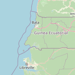
Map view of Akanda National Park

Use this park location map to pinpoint Akanda National Park in Gabon, understand its exact geographic position, and read its mapped placement within the surrounding landscape more clearly.

Pigeon | © OpenStreetMap contributors

Location context for Akanda National Park

Estuaire Province
Park atlas

Compare the regional protected areas surrounding Akanda National Park, focusing on Gabon's coastal wetlands and unique marine conservation zones.

National Parks and Protected Areas Near Akanda National Park, Gabon: Continue Your Coastal Park Discovery

Browse other national parks and protected areas geographically connected to Akanda National Park, exploring Gabon's vital coastal ecosystems and significant wetland environments. Comparing these regional protected landscapes reveals the broader context of mangrove forests, migratory bird habitats, and crucial marine conservation zones along the Atlantic coast.
National parkGabon
23 km away#1 closest

South

Pongara National Park: Protected Landscape and Geographic Exploration in Gabon

Mapped boundaries and regional natural context.

Pongara National Park is a designated national park within Gabon, offering a unique opportunity for structured exploration of protected lands. Users can investigate its specific geographic setting, understand its mapped boundaries, and appreciate its place within the regional landscape context. This entry provides a factual foundation for understanding the park's identity as a protected natural area and its contribution to Gabon's geography.

Area
929 km²
Established
2002
IUCN
II
Relief
Lowland
National parkWoleu-Ntem Province
48 km away#2 closest

East

Crystal Mountains National Park: National Park Protected Area and Geographic Context in Woleu-Ntem Province

Explore its mapped boundaries and regional landscape.

Crystal Mountains National Park is a designated national park offering critical insights into its protected landscape and geographic setting. Users can explore the mapped boundaries of this protected area, understand its regional terrain, and gain context within Woleu-Ntem Province through structured geographic data. This page provides the foundational atlas information for comprehending the park's conservation significance and natural features.

Area
1,200 km²
Established
2002
IUCN
II
Relief
Mountain
Wildlife reserveEstuaire
71 km away#3 closest

South

Réserve de Wonga Wongué: Atlantic Coastal Protected Landscape and Wildlife Map

Explore the geography of Gabon's expansive lowland coastal reserve

Examine the geographic boundaries and protected landscape of Réserve de Wonga Wongué, a crucial site in Gabon that features a blend of forest, hill, and plateau terrain. This reserve provides a comprehensive look at coastal river systems, marshes, and the habitats of central African megafauna along the Atlantic shore, highlighting its role as a Ramsar Wetland of International Importance and its evolving identity as a conservation area.

Area
4,281 km²
Established
1972
National parkEquatorial Guinea
About 107 km away#4 closest

Northeast

Monte Alén National Park National Park: Mapped Protected Landscape in Equatorial Guinea

Explore regional geography and park boundaries.

Monte Alén National Park, a designated national park in Equatorial Guinea, offers a unique focal point for understanding protected landscapes. This entry provides detailed geographic context, highlighting the park's mapped boundaries and its significance within the atlas of Central African natural terrain. Investigate the terrain and regional setting of Monte Alén National Park for structured geographic discovery.

Area
2,000 km²
Established
1990
IUCN
II
Relief
Mountain
National parkCameroon
167 km away#5 closest

North

Campo Ma'an National Park: Essential Protected Landscape in Cameroon's Atlantic Biafran Forest

Mapped evergreen canopy and vital great ape habitat in a key conservation area.

Campo Ma'an National Park is a crucial protected area in Cameroon, spanning 2,680 square kilometers of dense Atlantic Biafran forest. Established for environmental compensation, it safeguards critical habitat for western lowland gorillas and central chimpanzees, alongside forest elephants and diverse birdlife. The park's landscape is defined by a persistent evergreen canopy ecosystem, offering a unique context for understanding Central African rainforest geography and protected land status.

Area
2,680 km²
Established
2000
IUCN
II
Climate
Tropical
National parkEquatorial Guinea
About 174 km away#6 closest

East

Altos de Nsork National Park: Equatorial Guinea's Protected Landscape and Map Context

Explore the mapped boundaries of this national park.

Altos de Nsork National Park stands as a designated national park within Equatorial Guinea, offering a distinct protected landscape. This entry provides essential atlas-driven details, emphasizing its geographic setting and mapped park boundaries. Understand its regional context and its significance as part of the conservation network in Central Africa, contributing to a richer understanding of mapped natural terrains.

Area
700 km²
Established
2000
IUCN
II
Relief
Highland
Marine protected areaCameroon
183 km away#7 closest

North

Parc national marin Manyange na Elombo-Campo: Marine Protected Area and Regional Geography

Coastal conservation mapping in the South Region of Cameroon

Spanning a vast offshore territory in the Atlantic Ocean, Parc national marin Manyange na Elombo-Campo represents a major step in Central African marine conservation. The park boundary encompasses complex seafloor topography and river-mouth influences that provide essential habitat for vulnerable marine species. This atlas entry provides a detailed look at its marine extent and its integration into the larger Gulf of Guinea protected corridor.

Area
42,364 km²
Established
2021
Relief
Lowland
Climate
Tropical
Watercolor painting of a landscape with grassy areas, a lake, and distant hills under a light sky
National parkGabon
190 km away#8 closest

Southeast

Lopé National Park: Gabon's Protected Landscape and National Park Geography

Explore mapped boundaries and natural terrain in Central Africa.

Delve into Lopé National Park, a designated national park situated in Gabon. This protected area serves as a crucial point for understanding the nation's geography and the distribution of its conservation landscapes. As an entry in the MoriAtlas, it offers a detailed view of its mapped territory and its contribution to the broader regional context of Central Africa, emphasizing its role in protected area atlas exploration.

Area
4,910 km²
Established
2002
IUCN
II
Relief
Mixed relief

Common questions about visiting, size, designation, and location context for Akanda National Park

Akanda National Park FAQs for park facts, access, geography, and protected area context

Find quick answers about Akanda National Park, including protected-area facts, park geography, trail and visitor context, and how the park fits into its surrounding country and regional landscape.
MoriAtlas Explorer

Continue Your Protected Areas Search Across the Global Atlas

Deepen your exploration by continuing the structured search for national parks and protected areas worldwide. Utilize the comprehensive filtering capabilities to compare different conservation landscapes and refine your understanding of global park geography. Discover more about the distribution and characteristics of protected natural areas.

Global natural geography