
Why Bakhtegan National Park stands out
Bakhtegan National Park is best known for its role as a major migratory bird sanctuary, particularly for greater flamingos and diverse waterfowl populations. The area was historically one of Iran's most significant wetland ecosystems, serving as a critical breeding and staging ground for birds migrating along the Persian Gulf flyway. The Ramsar designation in 1975 recognized its international importance as a wetland habitat. The lake's dramatic fluctuations, including periods of complete drying, have made it a notable case study in regional water management and conservation challenges.
Bakhtegan National Park history and protected-area timeline
The Bakhtegan wetland system has undergone significant changes in recent decades. The lake and surrounding marshes were designated as a Wetland of International Importance under the Ramsar Convention in 1975, recognizing the area's exceptional ecological value. The construction of several dams on the Kor River upstream dramatically reduced water flow into the lake system, leading to increased salinity and ecological degradation. The lake experienced periods of reduced water levels throughout the 1990s and early 2000s, and subsequently dried completely between 2008 and 2010. This desiccation had severe consequences for the ecosystem, eliminating the habitat that supported large populations of flamingos and migratory birds. The decline of the Bakhtegan wetland has become a significant environmental concern in Iran, highlighting the tensions between water development projects and conservation priorities in the region.
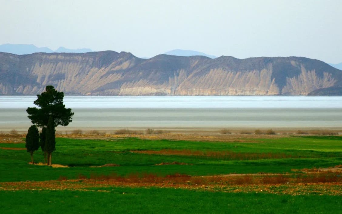
Bakhtegan National Park landscape and geographic character
The Bakhtegan landscape is characterized by a large, shallow lake basin set within the arid terrain of Fars province in southern Iran. The lake occupied a depression in the basin, with a generally flat surrounding landscape that included extensive marshlands, delta areas where the Kor River entered the lake, and seasonal wetlands. The lake system historically included connected water bodies, with Lake Tashk to the north joining with Bakhtegan during periods of high water. The area includes islands such as Menak Island within the lake's historical extent. The broader region is part of a semi-desert environment where the wetland system represented a significant contrast to the surrounding arid lands, creating a unique ecological island within the provincial landscape.
Bakhtegan National Park ecosystems, habitats, and plant life
The Bakhtegan wetland system represented a unique ecological environment in the arid context of southern Iran. The shallow, saline lake supported specialized halophytic vegetation adapted to variable salinity levels, while the surrounding marshes and delta areas provided freshwater and brackish habitats. The wetland complex supported rich biodiversity, particularly in terms of waterfowl and bird life. The interconnected nature of the lake, marshes, and river delta created a mosaic of habitats that supported different species throughout the annual cycle. The spring-fed marshes on the western side of the system and the large permanent spring in the northwest contributed to the ecological diversity of the area, maintaining wet habitats even during dry periods.
Bakhtegan National Park wildlife and species highlights
Bakhtegan was historically renowned for its exceptional bird populations. As of 1992, the lakes supported more than 120,000 ducks representing multiple species, making it one of the most important duck habitats in Iran. The greater flamingo population was particularly significant, with an estimated 50,000 individuals present, representing one of the largest concentrations of this species in the region. The wetland served as a critical stopover and breeding site for migratory birds traveling along the Persian Gulf flyway. The lake's drying eliminated much of this wildlife habitat, causing the local extinction of flamingo populations and the displacement of waterfowl to other areas. The loss of this wetland has had significant implications for regional biodiversity and migratory bird populations.
Bakhtegan National Park conservation status and protection priorities
The designation of the Bakhtegan area as a Ramsar site in 1975 reflected its recognized international importance as a wetland ecosystem. The protected status aimed to conserve the wetland's biodiversity, waterbird populations, and the ecological functions the area provided. However, the conservation framework faced significant challenges from water development projects in the Kor River basin that reduced inflows to the lake. The subsequent drying of the lake demonstrated the limitations of protected area designations without adequate attention to the broader watershed and water allocation issues. The Bakhtegan case has become illustrative of the challenges facing wetland conservation in arid regions where water resources are contested between agricultural, industrial, and environmental needs.
Bakhtegan National Park cultural meaning and human context
The Bakhtegan wetland held cultural and economic significance for local communities in Fars province. The lake and surrounding marshes supported traditional fishing and provided grazing areas for livestock in the surrounding dry landscape. The town of Neyriz located nearby had historical connections to the lake system. The Persian name for the lake, Daryache-ye Bakhtegan, reflects its place in the regional toponymy. The area's ecological changes have had implications for local communities who depended on the wetland's resources, representing the broader relationship between human communities and wetland ecosystems in southern Iran.
Top sights and standout views in Bakhtegan National Park
The Bakhtegan area represents a significant wetland ecosystem in the Middle East that has experienced dramatic ecological change. The Ramsar designation in 1975 recognized its international importance as a habitat for waterbirds, particularly its large populations of greater flamingos and ducks. The lake's historical role as Iran's second-largest lake and a critical node in migratory bird routes gave it regional significance. The complete drying of the lake system between 2008 and 2010 marked a major ecological shift, transforming one of Iran's most important wetlands into a dry basin and highlighting the environmental challenges facing wetland ecosystems in arid regions.
Best time to visit Bakhtegan National Park
The best time to observe the historical wildlife of the Bakhtegan area would have been during the autumn migration period when large numbers of waterfowl arrived at the wetlands. Winter months traditionally held the highest concentrations of flamingos and ducks, with the shallow waters providing ideal feeding habitat. The spring period supported breeding activities for many bird species. However, the lake has experienced significant environmental changes, and the historical patterns of wildlife abundance may no longer apply. Visitors interested in the region's ecological history and conservation challenges can gain insight into the broader issues facing wetland ecosystems in Iran.