

Why Beit She'arim National Park stands out
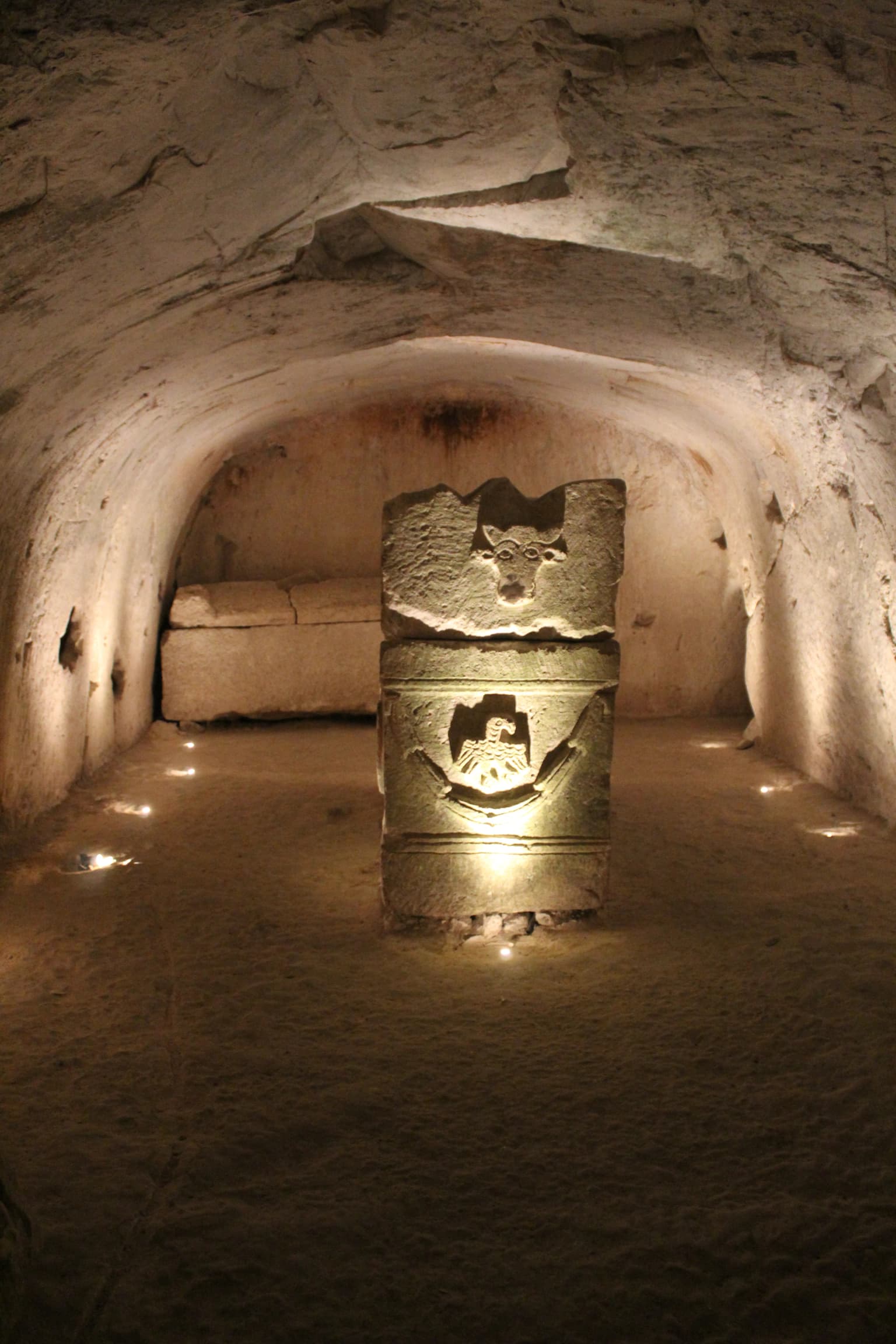
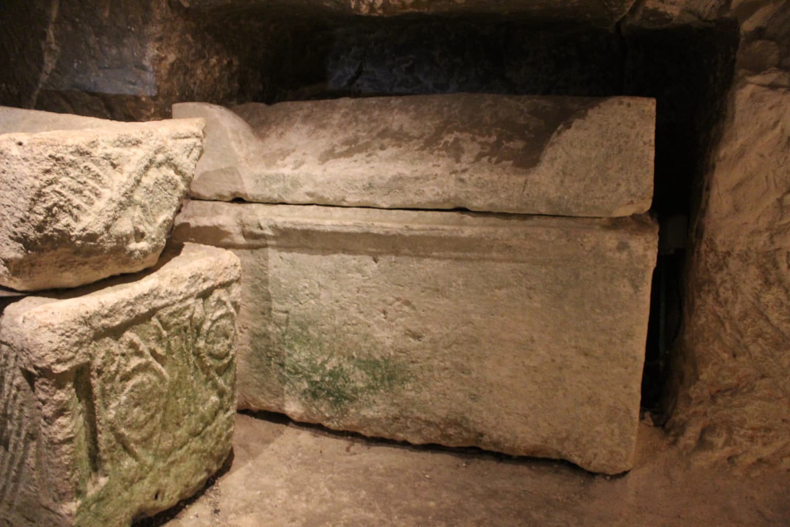
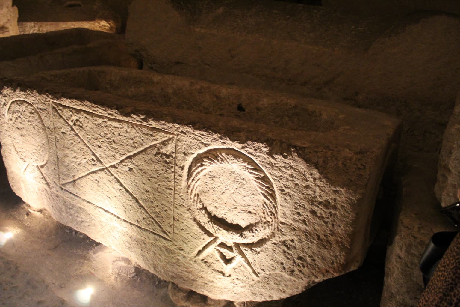
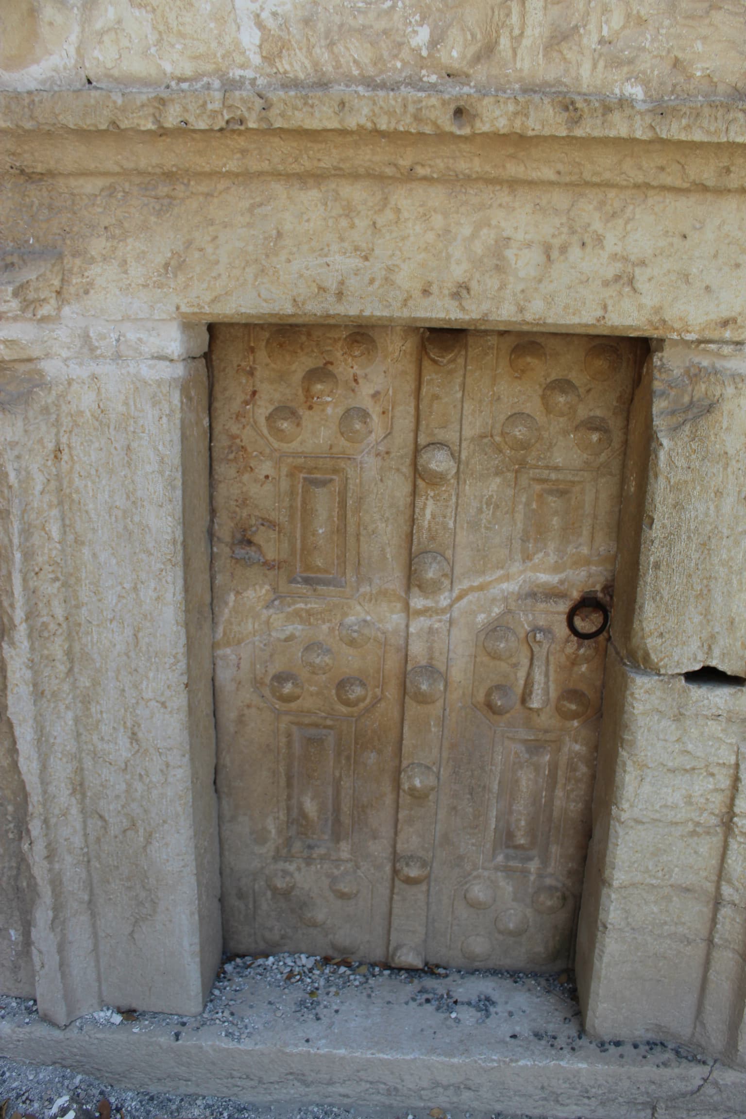
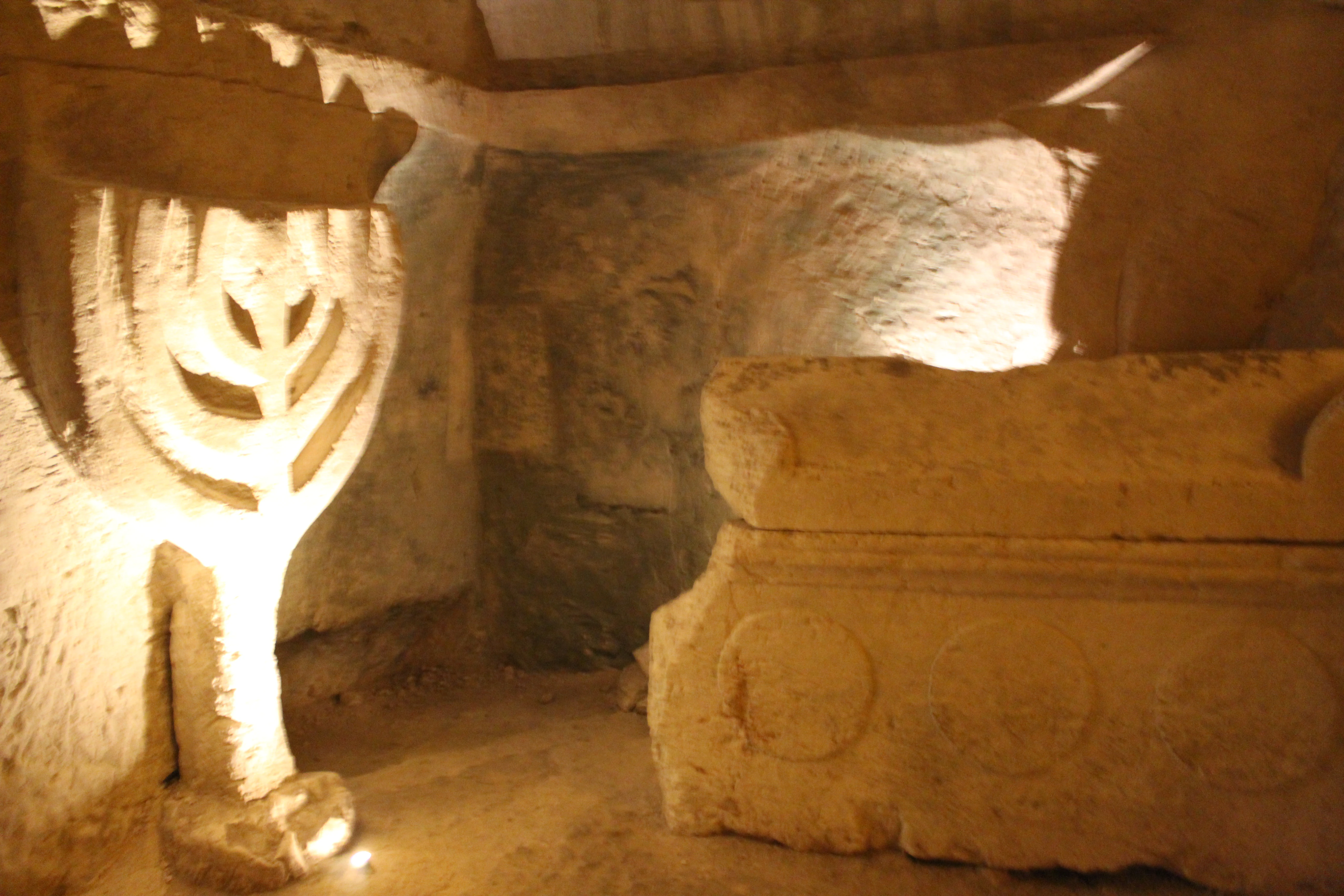
Beit She'arim is best known for its extraordinary ancient Jewish necropolis, which served as the principal burial ground for Jews during the late Second Temple and early Talmudic periods. The site is famous for housing the burial place of Rabbi Judah ha-Nasi, compiler of the Mishnah and president of the Sanhedrin, whose presence made Beit She'arim the most desired burial location after Jerusalem. The necropolis is renowned for its wealth of artistic adornments, including elaborate sarcophagi decorated with Jewish symbols, menorahs, Hellenistic mythological scenes, and geometric patterns. The nearly 300 inscriptions found in multiple languages provide invaluable historical and cultural documentation of Jewish life in late antiquity. The park also contains a significant Abbasid-period glassmaking facility from the 9th century, representing the site's continued importance through later historical periods.
Beit She'arim National Park history and protected-area timeline
The history of Beit She'arim spans multiple periods beginning with Iron Age settlement evidence through the present day as a national park. The town was founded at the end of the first century BCE during the reign of Herod the Great and appears in Josephus writings as Besara, serving as the administrative center for Queen Berenice II's estates in the Jezreel Valley. After the destruction of the Second Temple, the Sanhedrin migrated through several locations before arriving at Beit She'arim, which became a major center of Jewish learning in the 2nd century. The period of greatest importance came when Rabbi Judah ha-Nasi, compiler of the Mishnah and leader of the Jewish people, made Beit She'arim his home and burial place. Following his death, the necropolis became the preferred burial site for Jews across the region. In the Early Islamic period, the site saw sparse settlement, though excavations have uncovered Umayyad and Abbasid period artifacts including a significant 9th-century glassmaking facility. The site was known as Sheikh Bureik in the Ottoman period and was depopulated in the 1920s as part of the Sursock Purchases. Archaeological identification of the site as Beit She'arim occurred in 1936 by Samuel Klein, and systematic excavations began in the 1930s under Benjamin Mazar and Nahman Avigad, with work continuing today under Adi Erlich of the University of Haifa.
Beit She'arim National Park landscape and geographic character
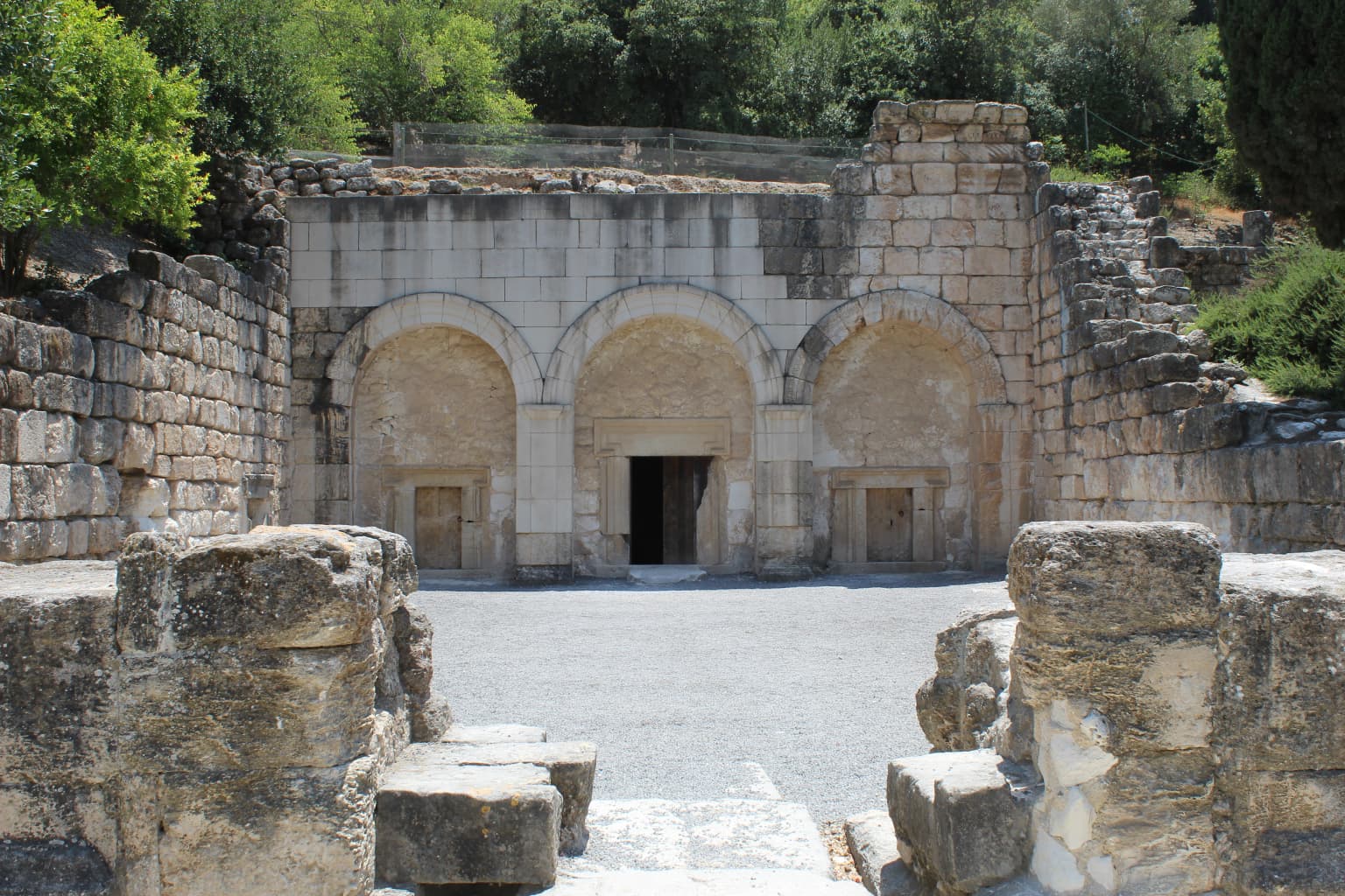
The landscape of Beit She'arim National Park is characterized by the soft limestone hills of the southern Lower Galilee, where the ancient builders carved an extensive network of burial caves into the terrain. The necropolis occupies a series of rock-cut catacombs that extend horizontally into the limestone formation, creating a complex underground architectural space. The surrounding area consists of agricultural land and modern settlements, with the park bordering Kiryat Tiv'on to the northeast. The limestone quality of the geological formation allowed for relatively easy carving while still providing sufficient structural integrity for the elaborate burial chambers, corridors, and decorated rooms that characterize the site. The landscape reflects the transition between the Mediterranean coastal plain and the interior Galilee hills, positioned in a strategic location along ancient trade routes that contributed to the site's importance as a regional center.
Beit She'arim National Park ecosystems, habitats, and plant life
While Beit She'arim is primarily an archaeological site, the national park setting includes the natural Mediterranean landscape of the Lower Galilee region. The park's terrain supports typical Mediterranean vegetation adapted to the limestone terrain and climate of the region. The area represents a transitional ecological zone between the coastal plain and the inland hills, supporting diverse plant communities characteristic of the eastern Mediterranean. The park's significance from a nature perspective lies primarily in its protection of the archaeological landscape and the limestone cave ecosystems that have developed over centuries. The surrounding agricultural lands and the park's position within the Lower Galilee contribute to the broader ecological context of the region, though the site is not primarily known for biodiversity or ecological habitats.
Beit She'arim National Park wildlife and species highlights
Wildlife at Beit She'arim National Park is not the primary focus of the site, which is renowned primarily for its archaeological and historical significance. The park does support typical Mediterranean fauna common to the Lower Galilee region, including various bird species, small mammals, and insects adapted to the agricultural and rocky terrain surrounding the ancient necropolis. The limestone caves within the park provide potential habitat for bats and other cave-dwelling species. However, the site is not designated or recognized for significant wildlife populations or biodiversity, and the primary value lies in its cultural and archaeological heritage rather than ecological or wildlife characteristics.
Beit She'arim National Park conservation status and protection priorities
Beit She'arim National Park holds significant conservation value as both an IUCN Category II protected area and a UNESCO World Heritage Site. The necropolis represents the most extensive ancient Jewish cemetery in the world, making its preservation crucial for understanding Jewish history and culture. Conservation efforts focus on protecting the delicate inscriptions, decorated sarcophagi, and architectural features from deterioration and damage. The Israel Nature and Parks Authority manages the park with responsibilities for preservation, visitor access, and ongoing research coordination. Archaeological excavations continue under academic supervision, with recent work since 2014 focusing on the ancient town above the necropolis. Conservation challenges include managing visitor access to the fragile cave systems while enabling public appreciation of the site, protecting inscriptions and artwork from environmental damage, and coordinating between archaeological research and conservation requirements.
Beit She'arim National Park cultural meaning and human context
The cultural context of Beit She'arim is deeply intertwined with Jewish history, rabbinic literature, and the development of Jewish identity in late antiquity. The necropolis serves as physical evidence of the Jewish diaspora's connection to the Land of Israel during the period following the destruction of the Second Temple. The presence of Rabbi Judah ha-Nasi and other rabbinic leaders established Beit She'arim as a spiritual and intellectual center, and the site features prominently in both the Jerusalem Talmud and Babylonian Talmud. The inscriptions and artwork at the site reflect the complex cultural interactions between Jewish communities and the broader Hellenistic world, showing how Jewish identity was expressed and maintained in a multicultural environment. The discovery of Himyarite tombs demonstrates the far-reaching connections between Jewish communities in Yemen and the Land of Israel. The later Islamic period history, including the famous Arabic elegy found in the Cave of Hell and the Abbasid glassmaking industry, illustrates the site's continued significance through subsequent historical periods.
Top sights and standout views in Beit She'arim National Park
The highlights of Beit She'arim National Park include the extraordinary Cave of the Coffins (Catacomb 20) with its elaborately decorated sarcophagi and menorah carvings, and Catacomb 14, believed to contain the family tomb of Rabbi Judah ha-Nasi. The nearly 300 inscriptions in multiple languages provide unprecedented documentation of Jewish life in late antiquity. The UNESCO World Heritage status recognizes the necropolis as a landmark of Jewish renewal. The ongoing archaeological excavations continue to reveal new information about the ancient town above the necropolis. The 9th-century glassmaking facility represents a unique industrial archaeological find. The site offers visitors a profound connection to Jewish history and the continuation of Jewish traditions across centuries.
Best time to visit Beit She'arim National Park
The best time to visit Beit She'arim National Park is during the cooler months from October through April, when outdoor exploration of the park's archaeological features is most comfortable. The Mediterranean climate of the Lower Galilee means summers can be hot, making extensive walking and cave exploration less pleasant. Spring particularly offers pleasant weather and the opportunity to see the surrounding landscape in bloom. Visitors should note that some catacombs are regularly open to the public while others require special arrangements. The park is managed by the Israel Nature and Parks Authority, and visitors should check current access conditions before planning their visit.