

Mori Atlas logo
National parkCentral Karakoram National Park

Discover the vast mapped boundaries and glacial geography of this unparalleled mountain national park.

Central Karakoram National Park: Pakistan's Highest Protected Landscape with K2 and Extreme Alpine Terrain

Central Karakoram National Park, situated in Pakistan's Gilgit-Baltistan region, represents an exceptional high-altitude protected landscape. Spanning over 10,000 square kilometers, this national park is globally recognized for encompassing K2, the world's second-highest mountain, alongside three other 8,000-meter peaks. Its terrain is defined by massive glacial systems like the Baltoro Glacier and dramatic granite spires, offering unparalleled alpine geography for exploration. Users can delve into the park's mapped boundaries, understand its extreme elevation gradient, and appreciate its significance as a premier destination for understanding high-mountain protected areas.

High-altitude protected areaGlacial landscapeMountain national parkK2KarakoramEight-thousanders

Central Karakoram National Park

National park

Park overview

Structured park overview, official facts, and landscape profile for Central Karakoram National Park

Central Karakoram National Park park facts, protected area profile, and essential visitor context

Review the core facts for Central Karakoram National Park, including designation, size, terrain, visitor scale, habitats, and operating context in one park-focused overview.

About Central Karakoram National Park

Central Karakoram National Park occupies a remote and spectacular corner of northern Pakistan, protecting a mountain landscape of extraordinary scale and diversity. The Karakoram range, of which this park forms a central portion, is one of Earth's most active mountaineering destinations, drawing expeditions from around the globe to attempt ascents on peaks that rank among the planet's highest and most technically challenging. The park's creation in 1993 marked an important step in Pakistan's conservation history, though for over two decades the protected area lacked a formal management framework. Following extended consultation with local stakeholders, a comprehensive management plan was finally adopted in 2015, establishing wildlife protection, tourism management, grazing regulation, and resource oversight across ten distinct sectors. The park's core zone encompasses the high-altitude glacial terrain and mountain peaks, while a buffer zone surrounds human settlements in the lower valleys. The region exhibits the Karakoram anomaly, a phenomenon by which glaciers in this range have remained relatively stable while similar glacial systems worldwide have retreated due to climate change.

Quick facts and research context for Central Karakoram National Park

Central Karakoram National Park covers roughly 10,557 square kilometers in northern Pakistan's Gilgit-Baltistan region. It was established in 1993 and holds IUCN Category II protection status. The park protects four peaks exceeding 8,000 meters, including K2, Gasherbrum I, Gasherbrum II, and Broad Peak, along with sixty peaks above 7,000 meters. Major glacier systems including Baltoro, Biafo, Hispar, and Panmah dominate the high-altitude landscape. A management plan was finally adopted in 2015 after decades of governance challenges, dividing the park into a 7,600-square-kilometer core zone and a 3,000-square-kilometer buffer zone.

Protection and recognition

Documented terrestrial boundaries and conservation management context within the Karakoram range

Central Karakoram National Park Protection Status and Designation Framework

Researchers can evaluate the official terrestrial protection status and conservation management scope documented for Central Karakoram National Park. Structured baseline data supports the clear exploration of global mountain reserves and protected territory boundaries.

Protection details

Protection scope
Terrestrial
Transboundary protection
No
Core area
7,600 km²
Buffer area
3,000 km²
Park context

Deeper park guide and search-rich context for Central Karakoram National Park

Central Karakoram National Park history, landscape, wildlife, and travel context

Explore Central Karakoram National Park through its history, landscape character, ecosystems, wildlife, conservation priorities, cultural context, and seasonal travel timing in a structured park guide built for atlas discovery and search intent.

Why Central Karakoram National Park stands out

Central Karakoram National Park is renowned for harboring K2, the world's second-highest mountain, along with three other 8,000-meter peaks and sixty peaks above 7,000 meters. The park contains the Baltoro Glacier, one of the longest non-polar glaciers on Earth, and the dramatic Trango Towers, which offer some of the world's most challenging big-wall rock climbing routes. It represents the highest national park on the planet and contains what is considered the greatest concentration of ultra-high peaks anywhere on Earth.

Central Karakoram National Park history and protected-area timeline

Central Karakoram National Park was established in 1993 as Pakistan's response to protecting the unique high-altitude ecosystems of the central Karakoram range. At the time of its creation, the park's boundaries were defined using four coordinates, but a formal management plan was not developed despite an International Union for Conservation of Nature proposal in 1994. For twenty years, the park operated without clear administrative guidance, prompting concerns about resource management, tourism oversight, and conservation effectiveness. A landmark management plan was finally adopted in February 2015 following extensive consultations with local communities, government agencies, and conservation stakeholders. This plan addressed ten sectors including wildlife protection, vegetation management, tourism, mining regulation, and community involvement. The park was placed on UNESCO's World Heritage Site Tentative List in 2016, recognizing its potential outstanding universal value as a natural heritage site.

Central Karakoram National Park landscape and geographic character

The Central Karakoram National Park encompasses an extraordinary alpine landscape characterized by massive granite peaks, extensive glacial systems, and deep river valleys. The terrain rises from approximately 2,000 meters above sea level in the valley bottoms to the summit of Chogori, known internationally as K2, at 8,611 meters. This dramatic elevation gradient creates a landscape of immense topographic variation, with steep cirques, towering rock walls, and sweeping glacial valleys. The park contains four of the world's fourteen 8,000-meter peaks and sixty mountains exceeding 7,000 meters, creating one of the most concentrated high-mountain environments on Earth. Glacier systems dominate the upper elevations, with the Baltoro Glacier, Biafo Glacier, Hispar Glacier, and Panmah Glacier and their tributaries carving through the range. The famous Lukpe Lawo, or Snow Lake, sits at the confluence of the Biafo and Hispar glaciers, forming a spectacular glacial basin. The Trango Towers represent some of the world's tallest granite spires, rising dramatically above the surrounding terrain.

Central Karakoram National Park ecosystems, habitats, and plant life

The park features several distinct ecological zones reflecting the complex relationship between climate, topography, and vegetation in this high-altitude environment. Valley bottoms support agricultural communities cultivating wheat, maize, potatoes, pomegranates, and apricots. The lower slopes transition into alpine dry steppes characterized by gravel and moraine soils supporting sparse grass and scrub vegetation. Sub-alpine scrub communities occupy areas beside rivers and streams, in gullies and ravines, providing important browsing habitat for both livestock and wild ungulates. Higher elevations feature alpine meadows and open coniferous forest, available for grazing only during the brief summer months. Above approximately 4,200 meters, permanent snowfields and cold desert conditions prevail, with only isolated patches of hardy, low-growing vegetation surviving in this extreme environment. The region experiences low precipitation overall but receives humid westerly winds that influence local vegetation patterns.

Central Karakoram National Park wildlife and species highlights

The park supports a specialized assemblage of large mammals adapted to the harsh high-altitude environment. The endangered Marco Polo sheep, one of the largest wild sheep species, inhabits the alpine zones, along with markhor, ibex, and urial. These species form the prey base for the snow leopard, a charismatic predator that roams the mountain terrain hunting pikas, hares, and gamebirds. Additional predators include mountain weasel, beech marten, brown bear, Asian black bear, Turkestan lynx, red fox, and Tibetan wolf. The park has been designated an Important Bird Area by BirdLife International, though bird species diversity is relatively low in this harsh environment. The Himalayan monal, a colorful pheasant, remains year-round in suitable habitat, while robin accentor and black-throated thrush overwinter in the area. Vultures, various birds of prey, rosefinches, and Güldenstädt's redstarts also inhabit the park, though many may move to lower elevations during winter. Three lizard species are present, while amphibians are notably absent.

Central Karakoram National Park conservation status and protection priorities

Central Karakoram National Park represents one of Pakistan's most significant protected areas and was placed on UNESCO's World Heritage Site Tentative List in 2016. The park protects a unique high-altitude ecosystem that remains relatively untouched by human development in its core zone. The 2015 management plan established a framework for sustainable resource use, dividing the park into strict protection zones and buffer areas surrounding settlements. Research using Landsat imagery from 2001 to 2010 demonstrated that the park's glaciers have remained substantially unchanged, in contrast to global retreat trends, representing the Karakoram anomaly. This stability makes the park particularly important for understanding glacier dynamics and climate change impacts. The designation as an Important Bird Area further recognizes its significance for avian conservation.

Central Karakoram National Park cultural meaning and human context

The park exists within the cultural landscape of Gilgit-Baltistan, a region with deep roots in traditional mountain communities. Local villages occupy valley bottoms where agriculture has been practiced for generations, with wheat, maize, and potatoes forming staple crops alongside fruit trees. The local communities have historically interacted with the mountain environment through pastoralism, with livestock grazing in sub-alpine and alpine zones during summer months. The area has been a destination for mountaineering expeditions since the early 20th century, creating a tradition of engagement between international climbing communities and local residents. Skardu serves as the nearest major city and administrative center for the region.

Top sights and standout views in Central Karakoram National Park

Central Karakoram National Park protects the world's highest concentration of 8,000-meter peaks, including K2, the planet's second-highest mountain. The park contains the Baltoro Glacier, one of Earth's longest non-polar glaciers, and the spectacular Trango Towers, offering world-class big-wall climbing. The region displays the Karakoram anomaly, where glaciers have remained stable while global glacial retreat continues. The landscape supports endangered species including the snow leopard and Marco Polo sheep. The park was added to UNESCO's Tentative List in 2016, recognizing its outstanding natural value.

Best time to visit Central Karakoram National Park

The optimal visiting period for Central Karakoram National Park spans from May through September, with July and August being the most popular months for mountaineering expeditions. May and June offer early-season climbing opportunities at lower altitudes, while September can provide excellent conditions for high-altitude ascents as weather stabilizes. The brief summer window provides the most accessible conditions for trekking and climbing, though visitors must contend with variable mountain weather and the challenges of high-altitude environments. Winter conditions are extremely severe, with heavy snow and extreme cold limiting access to the park's higher elevations.

Monthly climate preview

Long-term representative temperature ranges and monthly precipitation distributions

Central Karakoram National Park Climate Normals and Annual Weather Patterns

Central Karakoram National Park exhibits measured monthly temperature variation alongside consistent precipitation patterns recorded across a high-elevation coordinate. Reviewing the complete twelve-month climate profile provides detailed historical baseline data for analytical comparisons.
Annual mean-12 °C
-23 °C0 °C
Jan-23°
Feb-22°
Mar-18°
Apr-12°
May-8°
Jun-4°
Jul
Aug
Sep-5°
Oct-11°
Nov-17°
Dec-22°
Warmest month
July

-0.1 °C

Coolest month
January

-23.5 °C

Wettest month
August

0.8 mm/day

Driest month
October

0.2 mm/day

Park location guide

Geography guide, regional context, and park location map for Central Karakoram National Park

Central Karakoram National Park park geography, regions, and map view in Pakistan

Understand where Central Karakoram National Park sits in Pakistan through a broader geographic reading of the surrounding landscape, nearby location context, and its mapped position within the national park landscape.

How Central Karakoram National Park fits into Pakistan

Pakistan, officially the Islamic Republic of Pakistan, is a federal parliamentary Islamic republic in South Asia. It is the fifth-most populous country and the 33rd-largest by area. The country gained independence from British India in 1947 and has a diverse history spanning ancient civilizations including Mehrgarh and the Indus Valley Civilisation. Pakistan shares maritime borders with Oman and is bounded by the Arabian Sea, Gulf of Oman, and several neighboring countries.

Wider geography shaping Central Karakoram National Park in Pakistan

Pakistan is located in South Asia, bordered by the Arabian Sea to the south, the Gulf of Oman to the southwest, and shares land borders with India to the east, Afghanistan to the west, Iran to the southwest, and China to the northeast. The country also shares a maritime border with Oman in the Gulf of Oman. The Wakhan Corridor in Afghanistan separates Pakistan from Tajikistan in the northwest.

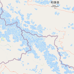
Map view of Central Karakoram National Park

Use this park location map to pinpoint Central Karakoram National Park in Pakistan, understand its exact geographic position, and read its mapped placement within the surrounding landscape more clearly.

Pigeon | © OpenStreetMap contributors

Location context for Central Karakoram National Park

Gilgit-Baltistan
Park atlas

Compare alpine landscapes, extensive glacier systems, and high-altitude protected areas across the wider Karakoram region

Discover Nearby National Parks and Protected Areas Surrounding Central Karakoram National Park

After exploring Central Karakoram National Park, browse other high-altitude protected areas and national parks in its geographic vicinity. Compare diverse mountain ranges, expansive glacial landscapes, and the broader protected area context of the Karakoram region for deeper geographic understanding.
National parkGilgit-Baltistan
About 116 km away#1 closest

Southwest

Deosai National Park: A Premier High-Altitude Alpine Wilderness and Protected Landscape in Pakistan

Mapped boundaries and unique terrain within Gilgit-Baltistan's geography.

Deosai National Park is a key protected area in Pakistan's Gilgit-Baltistan region, characterized by its high-altitude alpine meadows and expansive plateau terrain. As a national park, it offers crucial insights into mapped landscapes and regional geography, particularly for understanding conservation efforts in extreme environments. The park's setting provides a unique lens through which to explore the distribution and characteristics of protected lands within the broader atlas of natural landscapes.

Area
3,584 km²
Established
1993
IUCN
Ib
Relief
Highland
National parkHunza District
About 127 km away#2 closest

Northwest

Khunjerab National Park: Pakistan's High-Altitude Protected Landscape and Alpine Terrain

Discover dramatic Karakoram geography, wildlife habitats, and transboundary conservation.

Khunjerab National Park stands as a premier example of a high-altitude protected area, situated in Pakistan's Hunza District. This national park covers an immense territory within the Karakoram range, largely exceeding 4,000 meters. It provides a vital protected landscape for unique alpine wildlife, including critically endangered Marco Polo sheep and snow leopards, and functions as a critical transboundary conservation corridor. Explore the rugged terrain, glacial valleys, and dramatic mountain vistas that define this significant conservation area.

Area
2,269.13 km²
Established
1975
IUCN
II
Visitors
250K annual
Wildlife reserveGilgit-Baltistan
About 170 km away#3 closest

West

Astore Wildlife Sanctuary: Protected Alpine and Mountain Landscapes in Gilgit-Baltistan

High-altitude conservation area between Nanga Parbat and Deosai

Astore Wildlife Sanctuary encompasses over 400 square kilometers of diverse mountain terrain in Pakistan. Spanning from temperate river valleys to glaciated alpine peaks, the sanctuary safeguards critical habitats for threatened species like the Astor markhor and the Himalayan brown bear. Use this geographic atlas data to understand its unique position within the western Karakoram borderlands.

Area
414.72 km²
Established
1975
Relief
Mountain
Climate
Alpine
National parkGilgit-Baltistan
About 178 km away#4 closest

Southwest

Himalaya National Park: Exploring Its Protected Boundaries and Mountainous Landscape in Gilgit-Baltistan

Mapped protected area within Pakistan's northern mountain region.

Himalaya National Park serves as a significant protected entity within the dramatic geography of Gilgit-Baltistan, Pakistan. This national park offers a focused view of its specific natural terrain and mapped boundaries, contributing to a broader atlas of conservation lands. Users can discover the park's role as a protected landscape, examining its integration within the regional context and understanding its unique geographic characteristics. The focus here is on the park's protected status and its place in the mapped natural environment of Northern Pakistan.

Area
2,263 km²
Established
2021
IUCN
II
Relief
Mountain
National parkGilgit-Baltistan
About 186 km away#5 closest

Northwest

Qurumbar National Park: Pakistan's High-Altitude Protected Landscape and Geographic Atlas Point

Explore mapped alpine terrain, glacial features, and vital wildlife corridors.

Qurumbar National Park, situated in the rugged terrain of Gilgit-Baltistan, Pakistan, offers an unparalleled glimpse into a high-altitude protected landscape. This national park is defined by its dramatic alpine valleys, glacial features, and significant ecological value. As a key atlas point, it showcases the convergence of major Asian mountain systems and provides critical habitat for iconic mountain wildlife within its mapped boundaries.

Area
738 km²
Established
2011
IUCN
II
Relief
Mountain
National parkGilgit-Baltistan
About 195 km away#6 closest

Southwest

Nanga Parbat National Park: Protected Himalayan Landscape and Geographic Atlas

Explore mapped boundaries and alpine terrain in Gilgit-Baltistan.

Nanga Parbat National Park is a vast protected area defined by its spectacular Himalayan setting and dramatic alpine geography within Gilgit-Baltistan, Pakistan. As a national park, it safeguards the immense Nanga Parbat massif, its surrounding glaciers, and diverse altitudinal landscapes. This page offers an atlas perspective for understanding the park's geographic scope, its mapped natural features, and its significance as a protected mountain wilderness.

Area
1,785.61 km²
Established
2021
IUCN
II
Relief
Mountain
National parkPakistan
About 203 km away#7 closest

Southwest

Gurez National Park: Pakistan's Alpine Protected Landscape and Wildlife Habitat

Explore its mapped terrain and regional geographic context.

Gurez National Park stands as a protected national park within Pakistan's breathtaking Himalayan mountain system. This park is crucial for conserving the endangered musk deer and safeguarding a fragile alpine ecosystem characterized by dramatic valleys, steep peaks, and the flowing Kishenganga River. Its relative isolation preserves a unique natural landscape and traditional cultural heritage, making it a point of interest for understanding remote wilderness and conservation efforts within the South Asian atlas.

IUCN
II
National parkLeh district
About 227 km away#8 closest

South

Hemis National Park: Exploring India's Protected National Park Geography

Mapped boundaries and landscape context in Leh district.

Hemis National Park represents a distinct protected national park within the Leh district of India, offering unique geographic and landscape attributes for atlas exploration. This detailed entry focuses on the park's role as a conservation area, detailing its mapped extent and its contribution to the regional geography. Understand how Hemis National Park fits into the broader picture of protected lands, providing valuable context for those studying natural landscapes and territorial conservation across India.

Area
4,400 km²
Established
1981
IUCN
II
Relief
Mountain

Common questions about visiting, size, designation, and location context for Central Karakoram National Park

Central Karakoram National Park FAQs for park facts, access, geography, and protected area context

Find quick answers about Central Karakoram National Park, including protected-area facts, park geography, trail and visitor context, and how the park fits into its surrounding country and regional landscape.
MoriAtlas Explorer

Continue Your Protected Areas Search Across the Global Atlas

Deepen your exploration by continuing the structured search for national parks and protected areas worldwide. Utilize the comprehensive filtering capabilities to compare different conservation landscapes and refine your understanding of global park geography. Discover more about the distribution and characteristics of protected natural areas.

Global natural geography