
Why Dzanga-Ndoki National Park stands out
Dzanga-Ndoki National Park is renowned for its extraordinary population of western lowland gorillas, which reach densities here that are among the highest documented anywhere in Africa. The park is also famous for the Dzanga Bai, a massive sandy salt lick measuring 250 by 500 meters that serves as a critical gathering point for African forest elephants and other wildlife. This forest clearing, whose name translates to "village of elephants," provides rare opportunities to observe forest elephants in substantial numbers. The park's inclusion in the Sangha Trinational World Heritage Site underscores its global significance as a preserved rainforest ecosystem supporting multiple threatened species, including forest elephants, chimpanzees, and the endangered bongo antelope.
Dzanga-Ndoki National Park history and protected-area timeline
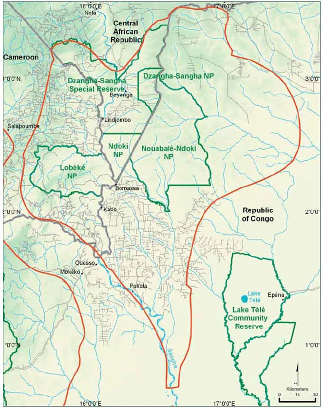
Dzanga-Ndoki National Park was established in 1990 as part of the Central African Republic's commitment to protecting its rainforest heritage. The park's creation responded to growing concerns about deforestation and wildlife population declines across the Congo Basin. In 1997, the Primate Habituation Programme was established at Bai Hokou in the Dzanga sector, initiating efforts to habituate gorilla groups for tourism and research purposes. The park was subsequently integrated into the broader Dzanga-Sangha Complex of Protected Areas, a framework designed to coordinate conservation efforts across multiple protected designations including national parks and special reserves. The year 2012 marked a major milestone when the Sangha Trinational, encompassing Dzanga-Ndoki along with adjacent protected areas in the Republic of the Congo and Cameroon, achieved UNESCO World Heritage status. That same year, the park gained international attention following the tragic poaching incident at Dzanga Bai where 26 African forest elephants were slaughtered, highlighting both the park's wildlife significance and the persistent threats facing its populations.
Dzanga-Ndoki National Park landscape and geographic character
The physical landscape of Dzanga-Ndoki National Park is defined by its position within the Congo Basin, characterized by relatively flat terrain ranging from 340 to 615 meters above sea level. The entire park sits atop alluvial sand deposits, a geological foundation that supports the extensive forest cover. The Sangha River, one of the major waterways of the region, flows through the park and serves as an important corridor for wildlife movement. A distinctive feature of the landscape is the presence of bai, forest clearings centered on marshy depressions along streams where the canopy opens dramatically. The most notable of these is Dzanga Bai, a substantial sandy clearing measuring 250 by 500 meters that has become emblematic of the park's identity. The forest composition varies across the park, with dryland forests featuring an open, mixed canopy dominated by Sterculiaceae and Ulmaceae species, while areas along watercourses support semi-evergreen swamp-forest, and certain zones feature the striking monodominant Gilbertiodendron dewevrei forest with its dense, closed canopy.
Dzanga-Ndoki National Park ecosystems, habitats, and plant life
The ecological character of Dzanga-Ndoki centers on its three distinct forest types that together create a diverse habitat matrix supporting exceptional biodiversity. The dryland forest comprises an open canopy system with a typically dense understorey featuring Marantaceae and Zingiberaceae plant families. The semi-evergreen forest zones, particularly along river corridors, incorporate swamp-forest areas that provide critical wet habitat diversity. The monodominant Gilbertiodendron dewevrei forest represents perhaps the most distinctive habitat type, forming extensive stands of this single tree species that create a remarkably dense, closed canopy environment. This habitat heterogeneity supports the park's remarkable vertebrate diversity, with intact populations of western lowland gorillas, African forest elephants, and chimpanzees representing the trifecta of large African forest mammals. The park's designation as an Important Bird Area reflects its significance for avian biodiversity, with over 350 bird species recorded and at least 260 species expected to breed within its boundaries.
Dzanga-Ndoki National Park wildlife and species highlights
Dzanga-Ndoki National Park harbors remarkable populations of forest-adapted wildlife, with the western lowland gorilla representing the park's most celebrated inhabitant. The Dzanga sector supports a gorilla density of 1.6 individuals per square kilometer, an extraordinary concentration that ranks among the highest ever documented for this critically endangered subspecies. African forest elephants congregate notably at the Dzanga Bai salt lick, where groups of dozens of elephants can be observed accessing mineral-rich soils. The park maintains viable populations of chimpanzees, giant forest hogs, red river hogs, and the elusive sitatunga antelope. The endangered bongo antelope persists here, as does the African forest buffalo and at least six species of duiker. The bird fauna is equally impressive, with over 350 species recorded, including the recently described Sangha forest robin, a species currently known only from the broader Dzanga-Sangha region pending further taxonomic investigation.
Dzanga-Ndoki National Park conservation status and protection priorities
Dzanga-Ndoki National Park occupies a central position in Central African conservation strategy as part of the transboundary Sangha Trinational World Heritage Site, recognized in 2012 for its outstanding universal value as a pristine forest ecosystem. The park's protection status provides legal framework for conserving populations of multiple globally threatened species, particularly the western lowland gorilla and African forest elephant, both listed as critically endangered. The designation as an Important Bird Area further acknowledges the site's significance for avian conservation. The Primate Habituation Programme at Bai Hokou represents an ongoing effort to develop sustainable tourism that supports both conservation and local communities while providing long-term monitoring data on gorilla populations. However, the park faces persistent threats from poaching, as dramatically illustrated by the 2013 incident in which 26 forest elephants were killed at Dzanga Bai, highlighting the ongoing challenges of protecting this remote wilderness.
Dzanga-Ndoki National Park cultural meaning and human context
The Dzanga-Ndoki region lies within the territory of local communities whose traditional livelihoods have long been intertwined with the forest environment. The name Dzanga itself carries cultural significance, with Dzanga Bai translating to "village of elephants" reflecting the historical presence and cultural importance of forest elephants to local populations. The park's management operates within the framework of the Dzanga-Sangha Complex of Protected Areas, which seeks to balance conservation objectives with sustainable use and community engagement. Traditional land use patterns in the surrounding areas include small-scale agriculture and resource gathering, with the protected area boundaries designed to accommodate both strict conservation zones and community use areas.
Top sights and standout views in Dzanga-Ndoki National Park
Dzanga-Ndoki National Park offers exceptional opportunities to observe some of Africa's most emblematic forest species in their natural habitat, with the Dzanga Bai clearing providing one of the most reliable locations anywhere to see African forest elephants in significant numbers. The park's gorilla populations, at densities among the highest recorded for western lowland gorillas, make it a critical site for great ape conservation and research. The monodominant Gilbertiodendron dewevrei forests create a visually striking landscape unlike typical tropical rainforest, with their dense, single-species canopy creating an almost cathedral-like atmosphere. As part of the Sangha Trinational World Heritage Site, the park represents international recognition of Central Africa's irreplaceable rainforest heritage and serves as a model for transboundary conservation cooperation.
Best time to visit Dzanga-Ndoki National Park
The optimal period to visit Dzanga-Ndoki National Park falls during the dry season, typically from November through April, when wildlife viewing opportunities are most favorable and accessibility within the park is improved. During this period, animals tend to concentrate more readily around water sources including the bai clearings, making elephant and other wildlife observations more predictable. The wet season, spanning roughly May through October, brings heavier rainfall that can restrict movement within the park and make some areas less accessible, though it offers alternative experiences of the forest ecosystem in its lusher state. Visitors should note that the park's remote location in southwestern Central African Republic requires careful logistical planning, and tourism infrastructure remains limited compared to more established destinations.