

Mori Atlas logo
National parkGabal Elba National Park

Mapping the protected area boundaries and natural terrain of Gabal Elba National Park in Egypt.

Gabal Elba National Park: Egypt's Protected Landscape and Geographic Atlas

Gabal Elba National Park represents a significant protected area within Egypt's diverse geography. This canonical detail page offers an atlas-driven exploration of its protected landscape, allowing users to understand its mapped boundaries and regional context. Discover the unique natural terrain and conservation significance of this important Egyptian national park.

Mist OasisBiodiversity HotspotMontane ForestAfrotropical BoundaryDesert MountainsRed Sea Coast

Gabal Elba National Park

National park

Park overview

Structured park overview, official facts, and landscape profile for Gabal Elba National Park

Gabal Elba National Park park facts, protected area profile, and essential visitor context

Review the core facts for Gabal Elba National Park, including designation, size, terrain, visitor scale, habitats, and operating context in one park-focused overview.

About Gabal Elba National Park

Gabal Elba National Park represents one of Egypt's most ecologically significant and geographically unique protected areas. Located in the Halaib Triangle at the southern tip of the Red Sea coast, the park encompasses a dramatic mountain landscape that rises sharply from the coastal plain to create a unique ecological island in the desert. The mountain's proximity to the Red Sea, combined with the slight eastward curvature of the coast at this point, creates a natural interception zone for moisture-laden northeast winds. These winds are forced upward against the mountain slopes, producing orographic precipitation that can reach 400mm annually in the upper elevations, compared to less than 50mm in the surrounding desert lowlands. This moisture system supports a

Quick facts and research context for Gabal Elba National Park

Gabal Elba National Park is located in the Halaib Triangle at Egypt's southern border with Sudan, along the Red Sea coast. The mountain reaches 1,435 meters elevation and creates a critical moisture corridor that supports Afrotropical species at their northern range limits. The park was established in 1986 and encompasses approximately 3.56 million hectares, including most of the disputed Halaib Triangle. It contains the largest remaining population of Dracaena ombet in Egypt and Sudan, and may harbor the last remaining Nubian wild ass. The area is claimed by both Egypt and Sudan but remains under Egyptian administration.

Protection and recognition

Mapping the 1986 terrestrial designation scope and transboundary status of the conservation area.

Documented Protection Status and Terrestrial Designation of Gabal Elba National Park

Gabal Elba National Park offers a complex terrestrial conservation profile established in 1986 to safeguard its unique geographical landscape. Comprehensive records outline the transboundary status and designated management framework of the protected area to assist researchers tracking global preservation efforts.

Protection details

Protection scope
Terrestrial
Designated year
1986
Transboundary protection
Yes
Park context

Deeper park guide and search-rich context for Gabal Elba National Park

Gabal Elba National Park history, landscape, wildlife, and travel context

Explore Gabal Elba National Park through its history, landscape character, ecosystems, wildlife, conservation priorities, cultural context, and seasonal travel timing in a structured park guide built for atlas discovery and search intent.

Why Gabal Elba National Park stands out

Gabal Elba is best known as Egypt's unique mist oasis, a place where the combination of Red Sea moisture and orographic lift creates a verdant montane environment in the midst of extreme desert aridity. The mountain supports the country's only natural woodland and hosts a remarkable concentration of Afrotropical species at their northern range limits, including the bateleur eagle, Nubian nightjar, and numerous other bird species. The Dracaena ombet (Gabal Elba dragon tree) forms distinctive woodland canopies in the mist zone, representing the largest remaining population of this species in both Egypt and Sudan. The park's biodiversity significance is underscored by the presence of 458 plant species, nearly a quarter of all plant species recorded in Egypt.

Gabal Elba National Park history and protected-area timeline

Gabal Elba National Park was officially declared by Egyptian Prime Minister Ahmed Nazif in 1986, establishing protection for this ecologically unique mountain landscape and the surrounding Halaib Triangle region. The establishment of the park came as recognition of the mountain's extraordinary biodiversity significance and the need to preserve Egypt's only natural woodland. The Halaib Triangle itself has been a source of dispute between Egypt and Sudan since the withdrawal of British administration in the 1950s, with the region currently under Egyptian control despite Sudanese claims. The park's creation also reflected growing Egyptian commitment to biodiversity conservation in the 1980s, a period when several major protected areas were established across the country.

Gabal Elba National Park landscape and geographic character

The Gabal Elba landscape is defined by a dramatic cluster of granite and metamorphic mountains rising from the Red Sea coastal plain. The highest peaks include Gabal Elba at 1,435 meters, Gabal Shellal at 1,409 meters, Gabal Shendib at 1,910 meters, and Gabal Shendodai at 1,526 meters. The mountains are located 15 to 30 kilometers inland from the Red Sea coast, with a relatively flat coastal strip of 20 to 25 kilometers separating them from the sea. The northeastern slopes receive significantly more moisture than the western and southern aspects, creating pronounced environmental gradients across the mountain mass. In the higher elevations, the mist zone supports dense woodland, while the lower foothills and wadis feature acacia savanna. The landscape is characterized by dramatic contrast between the verdant upper mountain slopes and the arid desert plains that surround the protected area.

Gabal Elba National Park ecosystems, habitats, and plant life

The ecological character of Gabal Elba is fundamentally shaped by its mist oasis hydrology, which creates a unique montane environment unlike anything else in Egypt. The summit region receives much of its precipitation in the form of dew, mist, and cloud cover, supporting a diverse flora of approximately 458 plant species, representing nearly 25% of all plant species recorded in the entire country. This extraordinary diversity includes many Afrotropical species whose northern limits fall at Gabal Elba. The mist zone features a distinctive woodland canopy composed primarily of acacia, Moringa, and Dracaena ombet, with ferns, mosses, and succulents in the understory. The foothills and wadis support savanna vegetation dominated by acacia and Delonix. The dense acacia scrub and woodland represents the only natural woodland in Egypt, a country otherwise characterized by extreme desert conditions.

Gabal Elba National Park wildlife and species highlights

Gabal Elba supports remarkable bird diversity with 41 species breeding in and around the mountain, many of them at the northern extent of their Afrotropical ranges. Notable species include the bateleur eagle, Namaqua dove, Nubian nightjar, shining sunbird, Arabian warbler, rosy-patched bushshrike, African silverbill, and Sudan golden sparrow. Raptors include Nubian vulture, bearded vulture, Egyptian vulture, Verreaux's eagle, and Bonelli's eagle. The mountain also supports the largest remaining population of Dracaena ombet in Egypt and Sudan, a critically significant botanical population. The park may also contain the last population of the Nubian wild ass, though the purity of these animals is questioned. In December 2014, an African leopard was killed in the park area, representing the first sighting of a leopard in Egypt since the 1950s. In 2024, a spotted hyena was documented in the area, representing the first occurrence in modern Egypt in over 5,000 years.

Gabal Elba National Park conservation status and protection priorities

Gabal Elba National Park represents a critical conservation priority as Egypt's only natural woodland and a unique biodiversity hotspot of international significance. The park's protection is particularly important given the presence of the only viable population of Dracaena ombet in Egypt and Sudan, a species of significant conservation concern. The mountain also potentially holds the last remaining population of the Nubian wild ass, an endangered equid subspecies. The 3.56 million hectare protected area encompasses most of the Halaib Triangle, preserving the corridor of moisture-dependent ecosystems that makes this desert mountain a biodiversity island. Recent wildlife observations, including the 2014 leopard sighting and 2024 spotted hyena occurrence, suggest the park may serve as a dispersal corridor for species expanding their ranges northward from Sudan, potentially indicating the conservation value of the area is even greater than previously understood.

Gabal Elba National Park cultural meaning and human context

The Halaib Triangle region, including Gabal Elba, has been the subject of a territorial dispute between Egypt and Sudan since the end of British colonial administration in the 1950s. Currently under Egyptian administrative control, the area is claimed by Sudan, creating a complex political context for conservation efforts. The mountain itself is known locally as Jabal ʿElba, deriving from the Arabic word for box, referring to the mountain's distinctive shape. The Bedouin communities in the region have historically utilized the mountain's water resources and grazing areas, though the establishment of the national park has modified access to certain areas.

Best time to visit Gabal Elba National Park

The optimal time to visit Gabal Elba National Park is during the winter months from November through March, when temperatures are milder and the mist conditions are most consistent in the higher elevations. The orographic precipitation system is most active during this period, creating the misty conditions that sustain the unique ecosystem. Winter visits offer the best opportunities to observe the mountain's characteristic mist veiling the upper slopes and to experience the contrast between the verdant highlands and the desert surroundings. Summer months can bring extreme heat, particularly in the lowland areas, making outdoor exploration challenging. The spring season may offer excellent birdwatching opportunities as migratory species pass through the area.

Monthly climate preview

Long-term representative point measurements tracking annual temperature and precipitation cycles

Gabal Elba National Park Climate Normals and Measured Temperature Rhythm

Representative coordinate records show measured monthly temperature variation alongside minimal baseline precipitation across the protected area. Reviewing the complete twelve-month climatology dataset clarifies long-term meteorological patterns and seasonal shifts.
Annual mean27 °C
19 °C34 °C
Jan19°
Feb20°
Mar22°
Apr26°
May30°
Jun32°
Jul34°
Aug34°
Sep31°
Oct29°
Nov24°
Dec21°
Warmest month
July

33.9 °C

Coolest month
January

18.9 °C

Wettest month
November

0.2 mm/day

Driest month
June

0 mm/day

Park location guide

Geography guide, regional context, and park location map for Gabal Elba National Park

Gabal Elba National Park park geography, regions, and map view in Egypt

Understand where Gabal Elba National Park sits in Egypt through a broader geographic reading of the surrounding landscape, nearby location context, and its mapped position within the national park landscape.

How Gabal Elba National Park fits into Egypt

Egypt is a transcontinental country bridging Northeast Africa and Southwest Asia via the Sinai Peninsula. With over 107 million inhabitants, it is the most populous country in the Arab world and third-most populous in Africa. The country features a rich historical heritage dating back to ancient civilizations along the Nile Delta, with Cairo as its capital and largest city.

Wider geography shaping Gabal Elba National Park in Egypt

Egypt occupies a strategic position in Northeast Africa, extending into Southwest Asia through the Sinai Peninsula. It is bordered by the Mediterranean Sea to the north, Palestine and Israel to the northeast, the Red Sea to the east, Sudan to the south, and Libya to the west. The Gulf of Aqaba in the northeast separates Egypt from Jordan and Saudi Arabia. The country features the Nile Delta and Valley as its main fertile region, surrounded by desert terrain.

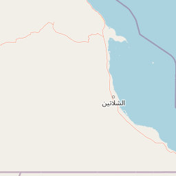
Map view of Gabal Elba National Park

Use this park location map to pinpoint Gabal Elba National Park in Egypt, understand its exact geographic position, and read its mapped placement within the surrounding landscape more clearly.

Pigeon | © OpenStreetMap contributors
Recorded earthquake history

Review Historical Seismic Activity Records for Gabal Elba National Park

Examine the recorded history of seismic events within the vicinity of Gabal Elba National Park. This catalogue provides a structured overview of documented epicentres, magnitudes, and proximity data to assist in understanding the regional seismic context of this significant Egyptian protected area.

Gabal Elba National Park Earthquake Records

Catalogued events

2 events

Strongest magnitude

Magnitude 4.3

Most recent event

Jan 16, 2014

This history includes earthquakes recorded inside the park or within 50 km of its borders

Park atlas

Explore connected protected landscapes and regional park geography surrounding Gabal Elba National Park in Egypt.

Compare Nearby National Parks and Protected Areas Around Gabal Elba, Egypt's Unique Mist Oasis

Explore a curated selection of other protected areas, tracing park geography across the surrounding Red Sea coastal plains and adjacent desert mountains of Egypt. This atlas view provides valuable context for comparing diverse conservation landscapes, revealing how unique ecosystems like Gabal Elba's mist oasis are situated within the broader region.
National parkEgypt
About 59 km away#1 closest

Northwest

Wadi El Gamal National Park: Protected Landscape and Geographic Atlas of Egypt

Explore the mapped terrain and protected boundaries.

Wadi El Gamal National Park is a key protected national park within Egypt, offering a unique lens through which to explore its geographic setting and mapped natural landscapes. This destination provides structured insight into the park's identity as a protected area, its place within the regional geography of Egypt, and the visual context of its terrain. Understand the mapped park boundaries and landscape features that contribute to its atlas value.

Access
Access unknown
National parkEgypt
About 59 km away#2 closest

Northwest

Wadi El Gemal National Park National Park: Egypt's Protected Landscape and Geography

Explore the mapped boundaries and regional context of this Egyptian national park.

Wadi El Gemal National Park offers a detailed look into a significant protected natural area within Egypt. As a national park, it presents a specific landscape identity with clearly defined geographic boundaries that are invaluable for atlas-based exploration. Users can delve into the mapped terrain and understand the regional geographic context surrounding this protected land, enhancing their comprehension of Egypt's natural heritage.

Area
6,870 km²
Established
2003
Relief
Mountain
Scope
Mixed
Protected areaEgypt
About 167 km away#3 closest

Northwest

Saluga and Ghazal Protectorate Protected Area: Mapped Boundaries and Egyptian Geography

Explore the protected landscape and regional geographic setting.

Delve into the specifics of the Saluga and Ghazal Protectorate, a designated protected area contributing to Egypt's natural landscape mosaic. This entry focuses on its mapped boundaries and geographic significance, providing essential context for atlas exploration. Understand the protectorate's terrain and its place within the national geography for a structured discovery experience.

Established
1986
Relief
Lowland
Access
Easy access
Scope
Terrestrial
National parkSudan
About 389 km away#4 closest

Southeast

Suakin Archipelago National Park: Sudan's Red Sea Marine Protected Area and Seabird Sanctuary

Explore the geography and mapped boundaries of this vital island ecosystem.

Suakin Archipelago National Park is a crucial protected area located in the Red Sea off Sudan's coast. This national park comprises a significant cluster of islets recognized for their abundant seabird nesting sites and as a critical habitat for marine fauna including sea turtles and dugongs. Its designation as an Important Bird Area underscores its international importance for coastal conservation, offering a distinct perspective on Sudan's natural geography and protected landscapes.

Area
1,500 km²
IUCN
II
Relief
Lowland
Climate
Arid
National parkSouth Sinai Governorate
About 438 km away#5 closest

North

Ras Muhammad National Park: South Sinai Protected Landscape and Geographic Atlas

Discover the mapped boundaries of this Egyptian national park.

Ras Muhammad National Park is a crucial protected area within the South Sinai Governorate, offering insights into Egypt's natural landscapes. This page facilitates an atlas-style exploration of the park, highlighting its geographic significance and protected status. Users can investigate its mapped terrain and understand its context within the regional geography of the Sinai Peninsula for structured geographic discovery.

Area
480 km²
Established
1983
Relief
Mixed relief
Climate
Arid
Protected areaSaudi Arabia
About 489 km away#6 closest

East

Mahazat as-Sayd Protected Area: Saudi Arabia's Protected Area Identity and Geographic Setting

Explore the mapped boundaries and regional desert terrain.

Mahazat as-Sayd Protected Area serves as a focal point for understanding protected landscapes within Saudi Arabia. This page details its specific protected area designation, highlighting its place within the country's broader geography. Users can gain insights into the mapped extent and the natural terrain characteristic of this significant Saudi Arabian conservation landscape.

Area
2,200 km²
Relief
Lowland
Climate
Arid
Access
Highly restricted
Protected areaSouth Sinai Governorate
About 494 km away#7 closest

North

Nabq Protected Area: South Sinai Governorate Protected Landscape and Regional Geography

Explore its mapped terrain and protected area context.

Nabq Protected Area offers a distinct view into Egypt's protected landscapes, situated within the South Sinai Governorate. This detailed page provides an atlas-style perspective on its geographic setting, allowing for structured exploration of its mapped boundaries and its role within the regional context. Understand the unique natural terrain and protected area characteristics that define this significant Egyptian site.

Area
600 km²
Established
1992
IUCN
VI
Relief
Mountain
National parkEgypt
About 526 km away#8 closest

North

Saint Katherine Protectorate National Park: Egypt's Protected Landscape and Geographic Identity

Mapped boundaries and regional terrain discovery for this Egyptian protected area.

Saint Katherine Protectorate is a key national park in Egypt, representing a significant protected landscape within the Sinai Peninsula. This page offers a detailed atlas view of its protected boundaries and geographic context. Users can explore its position within Egypt's broader geography and understand its role as a vital protected area for regional landscape study.

Established
1983
Relief
Mountain
Climate
Alpine
Access
Moderate access

Common questions about visiting, size, designation, and location context for Gabal Elba National Park

Gabal Elba National Park FAQs for park facts, access, geography, and protected area context

Find quick answers about Gabal Elba National Park, including protected-area facts, park geography, trail and visitor context, and how the park fits into its surrounding country and regional landscape.
MoriAtlas Explorer

Continue Your Protected Areas Search Across the Global Atlas

Deepen your exploration by continuing the structured search for national parks and protected areas worldwide. Utilize the comprehensive filtering capabilities to compare different conservation landscapes and refine your understanding of global park geography. Discover more about the distribution and characteristics of protected natural areas.

Global natural geography
