Mori Atlas logo
Nature reserveÎle du Grand Connétable National Nature Reserve

Discover the dramatic granite islands and surrounding marine environment off the coast of French Guiana.

Île du Grand Connétable National Nature Reserve: French Guiana's Premier Seabird Sanctuary and Coastal Protected Area

(Réserve naturelle nationale de l'Île du Grand Connétable)

The Île du Grand Connétable National Nature Reserve represents a unique protected landscape off the coast of French Guiana. Comprising two stark, treeless granite islands and a significant marine perimeter, this reserve serves as a critical nesting ground for numerous seabird species, including the Magnificent Frigatebird, and provides habitat for marine turtles and dolphins. Its dramatic cliff faces and surrounding waters offer a distinct view into coastal ecology and protected area geography within the South American context.

seabird sanctuarycoastal nature reserveFrench Guianatropical islandsbird nesting colonyIUCN Category IV
Illustrated landscape showing mountains, a winding river, dense forest, and a waterfall under a partly cloudy sky

Île du Grand Connétable National Nature Reserve

Nature reserve

Park overview

Structured park overview, official facts, and landscape profile for Île du Grand Connétable National Nature Reserve

Île du Grand Connétable National Nature Reserve park facts, protected area profile, and essential visitor context

Review the core facts for Île du Grand Connétable National Nature Reserve, including designation, size, terrain, visitor scale, habitats, and operating context in one park-focused overview.

About Île du Grand Connétable National Nature Reserve

The Île du Grand Connétable National Nature Reserve represents a unique protected area in the French overseas territories, established to safeguard one of French Guiana's most ecologically significant coastal sites. The reserve comprises two islands, Grand Connétable as the larger and more prominent feature, and the smaller Petit Connétable, both characterized by bare granite cliffs and rocky shores with virtually no vegetation due to exposure to salt spray and coastal winds. The surrounding marine environment extending five kilometers from the island shores adds substantial ecological value, protecting the coastal waters that support diverse marine species. The decision to establish this as a nature reserve in 1992 reflected growing recognition of the islands' importance as a biodiversity hotspot, particularly for colonial seabirds that congregate in significant numbers during breeding seasons. The reserve's establishment also marked an important milestone in French Guiana's conservation history, representing the first protected nature reserve in this region of tropical South America.

Quick facts and research context for Île du Grand Connétable National Nature Reserve

Located in French Guiana, an overseas department of France on the northeastern coast of South America, the reserve comprises two bare granite islands rising from coastal waters. Established in 1992 as French Guiana's inaugural nature reserve, the protected area is managed by the Conservatoire du littoral and classified under IUCN category IV for habitat and species management. The islands have a documented history dating to the 19th century, including brief American claims under the Guano Islands Act and phosphate mining operations on Grand Connétable. The reserve protects vital seabird nesting colonies and supports rich marine biodiversity in its surrounding ocean waters.

Protection and recognition

Evaluating the documented conservation framework and designated geographic boundaries of the nature reserve.

Île du Grand Connétable National Nature Reserve: Protection Status and Designated Area Profile

Analyzing the official protection status of Île du Grand Connétable National Nature Reserve provides essential context regarding its mixed conservation scope and designated boundaries. Factual records clarify the historical establishment and management parameters that safeguard the ecological integrity of the isolated island habitat.

Protection details

Protection scope
Mixed
Transboundary protection
No
Park context

Deeper park guide and search-rich context for Île du Grand Connétable National Nature Reserve

Île du Grand Connétable National Nature Reserve history, landscape, wildlife, and travel context

Explore Île du Grand Connétable National Nature Reserve through its history, landscape character, ecosystems, wildlife, conservation priorities, cultural context, and seasonal travel timing in a structured park guide built for atlas discovery and search intent.

Why Île du Grand Connétable National Nature Reserve stands out

The reserve is best known as a premier seabird nesting colony in northern South America. The islands serve as a critical breeding ground for the Magnificent Frigatebird, a large tropical seabird recognizable by its distinctive forked tail and impressive wingspan, as well as significant populations of Cayenne Tern, Royal Tern, and Laughing Gull. The dramatic contrast between the bare, windswept granite cliffs and the rich avian life they support makes this reserve a notable ecological site in the wider Amazon coastal region. The combination of terrestrial bird colonies and surrounding marine waters supporting dolphins and marine turtles creates an integrated coastal ecosystem of considerable conservation significance.
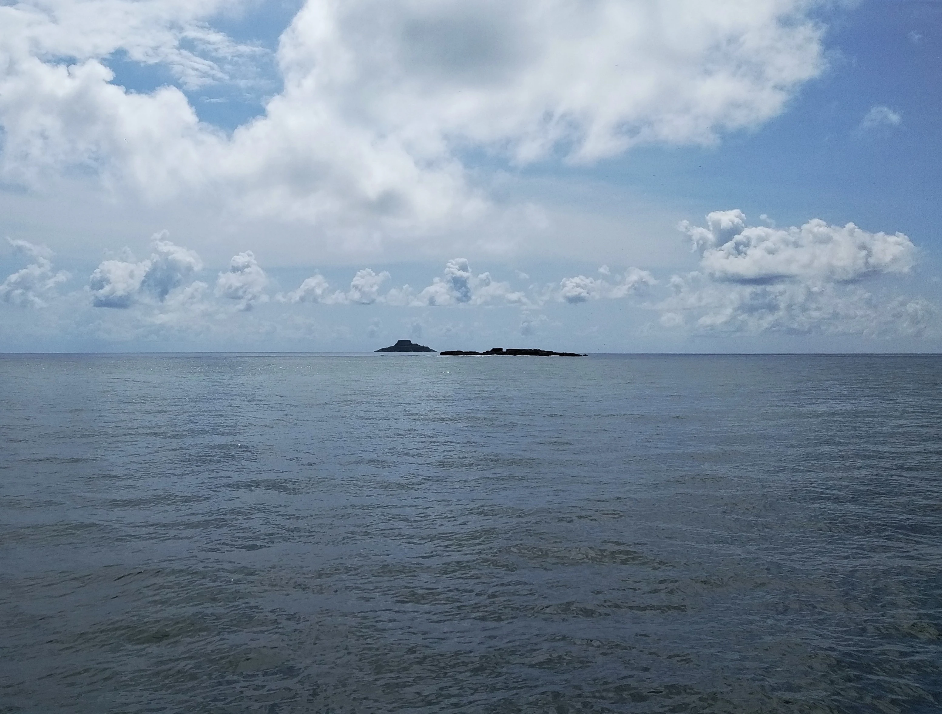
Calm ocean with two small islands on the horizon under a partly cloudy sky
Distant view of Île du Grand Connétable and Petit Connétable islands from the sea

Île du Grand Connétable National Nature Reserve history and protected-area timeline

The islands of the Connétable group have a layered historical record extending beyond their ecological significance. In 1856, the islands were claimed by the United States under the Guano Islands Act, a statute that enabled American citizens to claim uninhabited islands containing bird guano deposits as United States territory. This claim reflected the commercial value placed on guano as a fertilizer during the 19th century. Following this period of American interest, France undertook phosphate mining operations on Grand Connétable during the late 19th century, extracting mineral resources that had accumulated on the islands over centuries of seabird occupation. The transition from resource extraction to conservation protection came gradually as awareness grew regarding the islands' ecological value. On 8 December 1992, the French government officially designated the islands and surrounding waters as a nature reserve, making it the first such protected area in French Guiana and establishing a framework for long-term conservation of this important coastal ecosystem.

Île du Grand Connétable National Nature Reserve landscape and geographic character

The landscape of the Connétable islands is defined by stark, dramatic terrain characteristic of bare coastal outcrops in tropical marine environments. Grand Connétable and Petit Connétable rise as rugged granite islands from the coastal waters of French Guiana, their terrain completely devoid of trees and virtually without vegetation due to the harsh coastal conditions including constant wind exposure and salt spray. The islands feature steep cliff faces that emerge abruptly from the sea, creating a distinctive silhouette against the Atlantic horizon. The surrounding marine environment, extending five kilometers from the island shores, consists of shallow coastal waters supporting the rich biodiversity that complements the terrestrial bird colonies. This combination of exposed rock, cliff faces, and surrounding ocean creates a landscape of considerable visual and ecological distinction, one that supports an unexpected abundance of wildlife despite the apparent barrenness of the islands themselves.

Île du Grand Connétable National Nature Reserve ecosystems, habitats, and plant life

The ecological character of the reserve is defined by its function as a coastal seabird sanctuary within the broader context of French Guiana's tropical coastal ecosystem. Despite the treeless and seemingly inhospitable nature of the islands themselves, the reserve supports remarkable biodiversity, particularly during seabird breeding seasons when the cliff faces and rocky shores become populated by thousands of nesting birds. The surrounding marine environment adds another dimension to the reserve's ecological significance, with the protected ocean perimeter safeguarding coastal waters that support populations of marine mammals and sea turtles. The integration of terrestrial and marine protection within a single reserve designation reflects the interconnected nature of coastal ecosystems, where seabirds rely on marine fish stocks for food while contributing nutrients through guano deposition that enriches the islands' otherwise sparse terrestrial environment.

Île du Grand Connétable National Nature Reserve wildlife and species highlights

The wildlife of the reserve is dominated by seabird populations that use the islands as essential nesting and breeding habitat. The Magnificent Frigatebird is perhaps the most iconic species associated with the reserve, with large numbers of these distinctive seabirds nesting on the island cliffs. These frigatebirds are recognizable by their impressive wingspan and deeply forked tails, and they are known for their dramatic aerial displays during the breeding season. The islands also support significant colonies of Cayenne Tern and Royal Tern, two large tropical tern species that nest in dense colonies on the bare rock surfaces. Laughing Gull populations add to the avian diversity, with these medium-sized gulls establishing breeding colonies alongside the terns. Beyond birds, the surrounding marine waters are frequented by dolphins, with the Guianian Dolphin (Sotalia guianensis) documented in the waters near the islands. Marine turtles also utilize the broader marine environment within the reserve perimeter, though specific species details are limited in the available sources.

Île du Grand Connétable National Nature Reserve conservation status and protection priorities

The establishment of the Île du Grand Connétable National Nature Reserve in 1992 represented a landmark achievement for conservation in French Guiana and the wider Amazon coastal region. As the first nature reserve in French Guiana, the protected area was created in recognition of the exceptional ecological value of these islands for colonial seabirds, marine turtles, and coastal marine life. The reserve's IUCN category IV classification reflects its management focus on habitat and species protection, with the governing body, the Conservatoire du littoral, responsible for long-term stewardship of the coastal and marine environment. The protection encompasses both the terrestrial island environments and a substantial marine perimeter extending five kilometers outward, creating a comprehensive conservation framework that addresses the interconnected nature of terrestrial and marine ecosystems. The designation also acknowledged historical concerns about resource exploitation, as the islands had previously experienced phosphate mining that disrupted the natural environment.

Île du Grand Connétable National Nature Reserve cultural meaning and human context

While the reserve does not have deep documented connections to indigenous communities comparable to some other protected areas in French Guiana, the islands exist within a broader cultural landscape shaped by the region's complex colonial and post-colonial history. The islands are administratively part of the commune of Régina, which encompasses substantial portions of French Guiana's interior and maintains connections to the region's historical settlement patterns. The proximity to the Approuague River estuary, one of French Guiana's major waterways, places the islands within a coastal zone that has been traversed and utilized by various communities over centuries. The historical episode involving the 1856 American claim under the Guano Islands Act reflects the broader pattern of colonial-era territorial competition over small islands with valuable natural resources.

Top sights and standout views in Île du Grand Connétable National Nature Reserve

The reserve's highlights center on its function as a pristine seabird sanctuary and its dramatic coastal landscape. The sight of Magnificent Frigatebirds circling above the cliffs, their distinctive silhouettes against the tropical sky, represents perhaps the most memorable wildlife experience the reserve offers. The tern colonies, particularly the Cayenne Tern and Royal Tern, create dynamic scenes during breeding season when thousands of birds crowd the limited nesting terrain. The surrounding marine environment provides additional wildlife viewing opportunities, with Guianian Dolphins regularly encountered in the coastal waters. The bare, windswept quality of the islands, so different from the lush rainforest that dominates much of French Guiana, creates a distinctive visual landscape that underscores the ecological diversity of the region. As the first nature reserve in French Guiana, the site also carries symbolic significance for conservation in this part of South America.

Best time to visit Île du Grand Connétable National Nature Reserve

The reserve's tropical coastal location ensures a warm, humid climate year-round, with visitor conditions influenced by seasonal weather patterns typical of the Guianese coast. The dry season, typically occurring from mid-August to November, often provides more comfortable conditions for boat approaches to the islands and clearer visibility for wildlife observation. However, the reserve's remote nature and limited infrastructure mean that visits are generally limited to organized scientific expeditions, conservation activities, or managed tourism operations. The period corresponding to peak seabird breeding activity, typically falling in the first half of the year, offers the best opportunities to observe the full diversity of nesting species, though specific timing varies from year to year based on environmental conditions. Visitors should be prepared for the challenges of accessing a remote island environment in a tropical setting, including the need for suitable marine transport and awareness of weather-dependent access.

Monthly climate preview

Long-term temperature ranges and precipitation rhythm recorded at a representative coordinate

Île du Grand Connétable National Nature Reserve Climate and Monthly Weather Normals

Historical data from 1991 through 2020 outlines consistent average temperatures alongside shifting monthly precipitation across the reserve. Reviewing the complete twelve-month record clarifies multi-year climate patterns at this specific coordinate.
Annual mean27 °C
27 °C28 °C
Jan27°
Feb27°
Mar27°
Apr27°
May27°
Jun27°
Jul27°
Aug27°
Sep27°
Oct28°
Nov27°
Dec27°
Warmest month
October

27.5 °C

Coolest month
January

26.6 °C

Wettest month
May

13.9 mm/day

Driest month
September

1.4 mm/day

Park location guide

Geography guide, regional context, and park location map for Île du Grand Connétable National Nature Reserve

Île du Grand Connétable National Nature Reserve park geography, regions, and map view in French Guiana

Understand where Île du Grand Connétable National Nature Reserve sits in French Guiana through a broader geographic reading of the surrounding landscape, nearby location context, and its mapped position within the national park landscape.

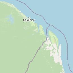
Map view of Île du Grand Connétable National Nature Reserve

Use this park location map to pinpoint Île du Grand Connétable National Nature Reserve in French Guiana, understand its exact geographic position, and read its mapped placement within the surrounding landscape more clearly.

Pigeon | © OpenStreetMap contributors

Location context for Île du Grand Connétable National Nature Reserve

French Guiana

Trace the distinctive terrain, cliff faces, and rich avian habitats that define this crucial protected area within French Guiana's Atlantic coast.

Île du Grand Connétable National Nature Reserve: Discover its Coastal Landscapes and Seabird Scenery

Browse a curated collection of photography capturing the stark coastal landscapes, rugged granite islands, and vibrant seabird habitats of Île du Grand Connétable National Nature Reserve. These images offer crucial visual insights into the protected marine environment, illustrating the unique ecological significance and wild character of this French Guiana sanctuary.

Calm ocean with two small islands on the horizon under a partly cloudy sky

A dolphin emerging from brownish water catching a fish

Park atlas

Explore other national parks and protected areas in the surrounding coastal geography of French Guiana.

Discover Other National Parks and Protected Areas near Île du Grand Connétable National Nature Reserve

Browse national parks and protected areas situated near Île du Grand Connétable National Nature Reserve, encompassing marine sanctuaries and coastal reserves along French Guiana's Atlantic coast. Expanding your discovery from a single island reserve into broader regional contexts helps compare diverse protected landscapes and trace their distinct conservation geography.
Nature reserveFrench Guiana
About 14 km away#1 closest

Southwest

Kaw-Roura Marshland Nature Reserve: A Protected Marshland Landscape in French Guiana

Explore its mapped terrain and regional geographic context.

Kaw-Roura Marshland Nature Reserve represents a distinct protected landscape within the tropical rainforests of French Guiana. This nature reserve offers detailed insights into marshland geography and terrain, contributing vital data for map-based exploration and understanding regional conservation patterns. Discover the specific protected boundaries and landscape character that define this important natural area, anchoring its identity within the larger geographic context of French Guiana.

Area
947 km²
Established
1998
IUCN
IV
Nature reserveFrench Guiana
About 44 km away#2 closest

Southwest

Trésor Regional Nature Reserve: Protected Nature Reserve in French Guiana's Guianas Region

Mapped Protected Landscape and Regional Geography

Investigate Trésor Regional Nature Reserve, a vital protected nature reserve located in French Guiana. This reserve is mapped as a significant component of the region's protected areas, contributing to the understanding of its unique tropical rainforest geography. Its designation underscores its importance for atlas exploration, offering structured insights into the natural landscapes that characterize this South American territory.

Area
24.64 km²
Established
2010
IUCN
IV
Relief
Mountain
Nature reserveFrench Guiana
About 47 km away#3 closest

West

Mont Grand Matoury Nature Reserve: French Guiana's Protected Landscape and Mapped Geography

Explore its protected boundaries and regional terrain.

Mont Grand Matoury Nature Reserve is an integral part of the protected areas network in French Guiana, offering a specific focus on its natural landscape and geographic setting. This entry provides a structured overview of the reserve, detailing its mapped extent and its contribution to the regional geography. Users can delve into the specifics of this protected land, understanding its character and location within the wider context of France's overseas territories and the Amazonian biome.

Area
21.23 km²
Established
2006
IUCN
IV
Relief
Mixed relief
Nature reserveFrench Guiana
About 116 km away#4 closest

Southwest

Nouragues Nature Reserve: Protected Nature Reserve Landscape within French Guiana's Amazon

Mapped geography featuring a distinct inselberg formation.

Nouragues Nature Reserve stands as a critical protected area within French Guiana, safeguarding a significant expanse of pristine lowland tropical rainforest. Its most defining characteristic is the Nouragues Inselberg, a colossal granite formation that dramatically punctuates the dense forest canopy. This reserve is not only a testament to conservation efforts but also a globally recognized hub for tropical forest ecology research. Exploring Nouragues Nature Reserve offers a unique lens into the natural processes and geological features of the Guiana Shield ecosystems.

Area
1,000 km²
Established
1995
IUCN
IV
Relief
Mixed relief
Watercolor painting of a landscape with rolling hills, green trees, and soft color gradients
National parkFrench Guiana
About 135 km away#5 closest

Southwest

Guiana Amazonian Park National Park: French Guiana's Expansive Protected Rainforest

Explore mapped boundaries and regional geographic context.

Guiana Amazonian Park, a cornerstone of protected land in French Guiana, offers a profound exploration of untamed Amazonian rainforest. As the largest national park in the European Union, it showcases a vast, remote ecosystem characterized by towering trees and intricate river systems. This page provides detailed context on its geographic placement within French Guiana and its significance as a major protected landscape for atlas-based discovery and understanding of tropical forest conservation.

Area
20,300 km²
Established
2007
IUCN
II
Relief
Lowland
Nature reserveFrench Guiana
About 153 km away#6 closest

West

La Trinité National Nature Reserve: French Guiana Protected Landscape & Nature Reserve Atlas

Mapping the natural terrain and protected boundaries.

Delve into the protected landscape of La Trinité National Nature Reserve, an integral part of French Guiana's extensive natural terrain. This explorer view provides specific insights into the reserve's mapped boundaries and its geographic context within the South American region. Understand its identity as a designated nature reserve and its contribution to the broader protected areas atlas for French Guiana.

Area
769.03 km²
Established
1996
IUCN
IV
Relief
Mountain
Nature reserveFrench Guiana
About 239 km away#7 closest

Northwest

Amana Nature Reserve Nature Reserve: French Guiana's Mapped Protected Landscape

Explore the geographic context and protected area identity.

Amana Nature Reserve is a vital protected area situated in French Guiana, a region renowned for its extensive tropical rainforests. As a nature reserve, it contributes significantly to the atlas of protected lands in South America, offering a distinct geographic identity. Understanding Amana Nature Reserve involves exploring its mapped boundaries and its place within the unique natural terrain of the Guianas, providing essential context for geographic discovery.

Area
148 km²
Established
1998
IUCN
IV
Relief
Lowland
National parkSuriname
About 359 km away#8 closest

West

Brownsberg Nature Park: Suriname National Park with Tropical Forest and Waterfall Landscapes

Mapped geography and protected landscape context.

Brownsberg Nature Park stands as a vital protected landscape within Suriname, distinguished by its central mountain, tropical forest ecosystems, and scenic waterfalls such as Leo Waterfall. The park's location overlooking the vast Brokopondo Reservoir provides a unique geographic setting, making it an important destination for atlas and map-based exploration of Suriname's natural heritage. Understanding Brownsberg Nature Park offers insight into the Neotropical biodiversity and terrain characteristic of the Guianan moist forests.

Area
122 km²
Established
1969
IUCN
II
Visitors
20K annual

Common questions about visiting, size, designation, and location context for Île du Grand Connétable National Nature Reserve

Île du Grand Connétable National Nature Reserve FAQs for park facts, access, geography, and protected area context

Find quick answers about Île du Grand Connétable National Nature Reserve, including protected-area facts, park geography, trail and visitor context, and how the park fits into its surrounding country and regional landscape.
MoriAtlas Explorer

Continue Your Protected Areas Search Across the Global Atlas

Deepen your exploration by continuing the structured search for national parks and protected areas worldwide. Utilize the comprehensive filtering capabilities to compare different conservation landscapes and refine your understanding of global park geography. Discover more about the distribution and characteristics of protected natural areas.

Global natural geography