

Mori Atlas logo
National parkJudbarra National Park

Explore the mapped geography and ancient Indigenous rock art of this expansive protected area.

Judbarra National Park: Northern Territory National Park Atlas and Protected Landscape

Judbarra National Park, located in Australia's Northern Territory, represents a significant protected area characterized by its vast scale and dual geographic sections. This national park is distinguished by its immense cultural heritage, featuring some of the country's most extensive Indigenous rock art sites, and by its position within a crucial ecological transition zone between tropical and semi-arid environments. Discover the unique terrain, mapped park boundaries, and the rich tapestry of natural and cultural landscapes that define Judbarra National Park within the broader Northern Territory geography.

Northern Territory national parksIndigenous rock art sitesImportant Bird AreasAustralian savanna ecosystemsSemi-arid wildernessTransitional ecological zones
Stylized illustration of desert landscape with red rock cliffs, green trees, and winding path

Judbarra National Park

National park

Park overview

Structured park overview, official facts, and landscape profile for Judbarra National Park

Judbarra National Park park facts, protected area profile, and essential visitor context

Review the core facts for Judbarra National Park, including designation, size, terrain, visitor scale, habitats, and operating context in one park-focused overview.

About Judbarra National Park

Judbarra National Park represents a vast and ecologically diverse protected landscape in Australia's Northern Territory. The park's extent of over 13,000 square kilometers places it among the nation's significant conservation areas, providing protection for diverse habitats ranging from rugged sandstone escarpments to seasonal floodplains and savanna woodlands. The park's dual-section geography, with its larger southwestern portion and smaller northeastern area, reflects the complex mosaic of landscapes that characterize this transitional environment between the wet tropics and the arid interior. Joint management arrangements with traditional owner groups have been central to the park's governance, ensuring that Indigenous knowledge and connections to Country inform conservation and visitor experiences. The park's remote location ensures relatively low visitor pressure compared to more accessible Northern Territory destinations, preserving a sense of wilderness and cultural continuity that distinguishes this landscape.

Quick facts and research context for Judbarra National Park

Judbarra National Park covers approximately 13,000 square kilometers of the Northern Territory's rugged interior, making it one of Australia's largest protected areas. The park was formally established in 1990 and was previously known as Gregory National Park before its renaming to reflect Indigenous heritage. It is governed by the Parks and Wildlife Commission of the Northern Territory under joint management arrangements with traditional owners. The park occupies a unique position in the Top End, straddling a transition between the wet-dry tropics and the semi-arid interior, creating distinctive ecological conditions. Several major Indigenous language groups maintain connections to Country within the park boundaries, spanning the linguistic boundary between Pama Nyungan and Non-Pama-Nyungan language families.

Protection and recognition

Mapping the terrestrial designation framework and official protection history of the reserve

Documented Protection Status and Conservation Profile of Judbarra National Park

Verified records outline the terrestrial protection status and established boundaries of Judbarra National Park within the regional conservation network. Structured geographic data assists researchers in verifying official designation frameworks and historical conservation parameters for the reserve.

Protection details

Protection scope
Terrestrial
Transboundary protection
No
Park context

Deeper park guide and search-rich context for Judbarra National Park

Judbarra National Park history, landscape, wildlife, and travel context

Explore Judbarra National Park through its history, landscape character, ecosystems, wildlife, conservation priorities, cultural context, and seasonal travel timing in a structured park guide built for atlas discovery and search intent.

Why Judbarra National Park stands out

Judbarra National Park is renowned as one of Australia's most significant repositories of Indigenous rock art. The rock shelters and caves scattered throughout the park contain extensive artistic creations executed through painting, stencilling, drawing, printing, and pecking and pounding techniques. The human figure emerges as the most common motif, and the park is recognized as one of the most prolific sites in the entire country for composite engraved and painted human figures. The rock art of the Judbarra region constitutes a distinct art province within the broader landscape of Australian Indigenous heritage, representing thousands of years of continuous cultural expression. Beyond its rock art significance, the park is notable for its position in the ecological transition between tropical and semi-arid zones and its status as an Important Bird Area supporting threatened species including the endangered Gouldian finch.
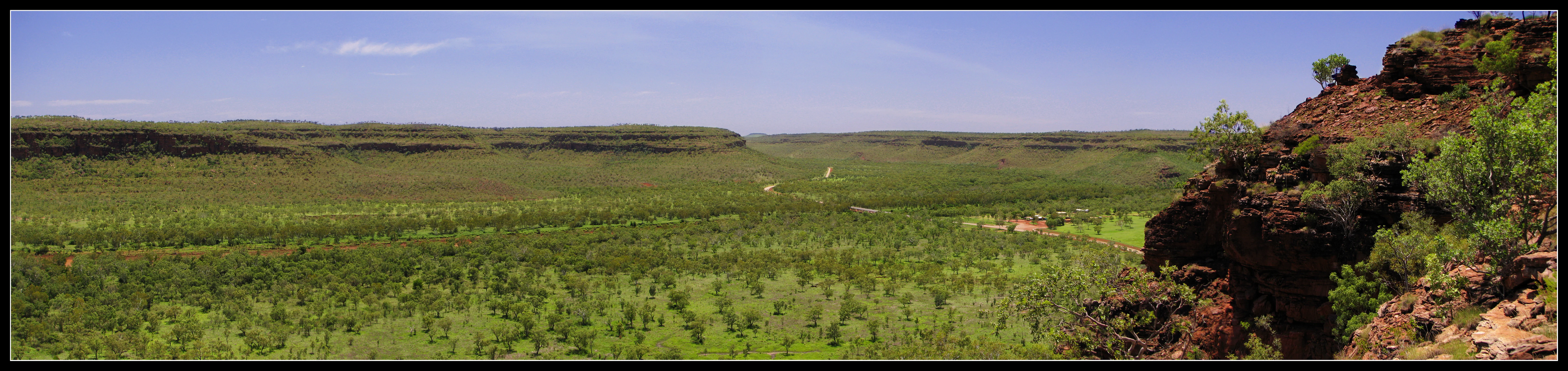
Wide panoramic view of a grassy plain with low hills in the distance and a rocky outcrop on the right side under a clear blue sky
Panoramic view of Judbarra National Park's grassy plains and rocky outcrops

Judbarra National Park history and protected-area timeline

The park was established in 1990 under the name Gregory National Park, honoring the explorer Francis Gregory who traversed the region in the nineteenth century. However, the park's Indigenous heritage and the deep connections of multiple Aboriginal groups to these lands prompted a collaborative renaming process with traditional owners. On 21 October 2011, a joint management plan announced that the park would carry the dual name Judbarra and Gregory for a period of ten years, acknowledging both historical and Indigenous significance. This period of dual naming concluded in 2021, when the park's official designation became simply Judbarra National Park, reflecting the primacy of Indigenous naming and the continuing partnership between park management and traditional owner groups. The governance structure involves the Parks and Wildlife Commission of the Northern Territory working in collaboration with the Indigenous groups whose ancestral lands the park encompasses.

Judbarra National Park landscape and geographic character

The landscape of Judbarra National Park encompasses a remarkable variety of terrain within its two disconnected sections. The terrain features sandstone escarpments, rocky outcrops, and rugged ridges interspersed with valleys and drainage systems that carry seasonal flows during the wet season. The vegetation transitions across the park's extent, reflecting the influence of the tropical-semiarid ecological boundary. Savanna woodlands dominate the more accessible areas, while rocky shelters and cliff faces provide the canvas for the extensive rock art that makes this region internationally significant. The separation of the park into distinct northeastern and southwestern sections reflects the irregular shape of the protected area as it follows landscape features and land tenure patterns across this remote portion of the Northern Territory.

Judbarra National Park ecosystems, habitats, and plant life

Judbarra National Park occupies a critical ecological position in the transition between Australia's tropical north and its semi-arid interior. This transitional zone creates conditions that support a diverse array of habitats and species assemblages characteristic of both wet and dry environments. The park has been identified by BirdLife International as an Important Bird Area, recognizing its significance for bird conservation at a continental scale. The park supports populations of several bird species of conservation concern, including the endangered Gouldian finch and the eastern subspecies of the white-quilled rock-pigeon. Beyond avifauna, the park's ecological diversity extends to numerous reptiles, mammals, and invertebrates adapted to the seasonal extremes of this region. A plant species, Solanum scalarium, known locally as Garrarnawun bush tomato, was discovered within the park and formally described in 2022, representing a plant known only from this protected area.

Judbarra National Park wildlife and species highlights

The wildlife of Judbarra National Park reflects the park's position at the intersection of tropical and semi-arid ecological zones. Birdlife is particularly significant, with the park's Important Bird Area designation recognizing populations of conservation-priority species. The endangered Gouldian finch occurs in small numbers within the park, representing one of the key locations for this colorful and highly restricted species. The eastern subspecies of the white-quilled rock-pigeon finds substantial habitat within the park, while other species including the partridge pigeon, chestnut-backed buttonquail, and yellow-rumped mannikin occupy various habitats throughout the area. Several savanna-biome and near-threatened species rely on the park's diverse vegetation communities. The seasonal patterns of the wet-dry tropics influence wildlife behavior, with distinct changes in animal activity and visibility across the year.

Judbarra National Park conservation status and protection priorities

Judbarra National Park contributes significantly to biodiversity conservation in the Northern Territory, protecting a substantial area of ecologically diverse terrain at the boundary between tropical and semi-arid zones. The park's Important Bird Area designation by BirdLife International recognizes the critical role it plays in supporting populations of threatened and restricted-range bird species. Conservation management within the park operates through joint arrangements between government agencies and traditional owner groups, integrating Indigenous knowledge and contemporary conservation science. The protection of rock art sites represents a unique dimension of conservation, combining cultural heritage preservation with landscape protection. The discovery of endemic plant species such as Solanum scalarium within the park highlights the continued potential for new biological discoveries in this relatively understudied remote landscape.

Judbarra National Park cultural meaning and human context

Judbarra National Park encompasses the traditional lands of multiple Indigenous Australian groups, including the Ngarinyman, Karrangpurru, Malngin, Wardaman, Ngaliwurru, Nungali, Bilinara, Gurindji, and Jaminjung peoples. These groups maintain deep connections to Country across the park's extent, with the landscape holding profound cultural, spiritual, and historical significance. The park spans the boundary between two major Australian language families, Pama Nyungan and Non-Pama-Nyungan, reflecting the complex linguistic landscape of the region. The rock art within the park represents an extraordinary cultural legacy, with thousands of years of artistic expression preserved in shelters and caves throughout the area. The collaborative management approach that led to the park's renaming reflects the ongoing recognition of Indigenous rights and knowledge in park governance.

Top sights and standout views in Judbarra National Park

The exceptional Aboriginal rock art, making Judbarra one of Australia's most prolific rock art provinces. The park's vast extent and remote character providing opportunities for wilderness experiences. The ecological transition between tropical and semi-arid zones supporting diverse habitats and species. The presence of the endangered Gouldian finch and other priority bird species. The cultural heritage spanning multiple Indigenous language groups and thousands of years. The discovery of endemic plant species unique to the park.

Best time to visit Judbarra National Park

The optimal time to visit Judbarra National Park aligns with the dry season, typically from May through October, when conditions are most comfortable for exploration and wildlife viewing is enhanced as animals congregate around remaining water sources. The wet season from November to April brings monsoonal rains that can make many areas inaccessible and result in flooded roads and tracks. During the dry season, temperatures are more moderate and the landscape remains accessible, though conditions can become warm during the middle of the day. The transition periods at the start and end of the dry season often offer excellent conditions for visiting, with pleasant temperatures and the landscape still retaining moisture from the preceding wet season.
Monthly climate preview

Long-term monthly temperature and precipitation averages for Judbarra National Park

Judbarra National Park Climate Normals and Annual Temperature Rhythm

Judbarra National Park records documented annual temperature shifts alongside distinct monthly precipitation patterns across a representative coordinate elevation of nearly two hundred meters. Examining the complete twelve-month climatology dataset clarifies long-term thermal variations and precipitation distribution across the protected landscape.
Annual mean27 °C
22 °C32 °C
Jan29°
Feb28°
Mar27°
Apr27°
May24°
Jun22°
Jul22°
Aug24°
Sep29°
Oct32°
Nov32°
Dec31°
Warmest month
November

32.4 °C

Coolest month
July

21.6 °C

Wettest month
February

8.2 mm/day

Driest month
August

0 mm/day

Park location guide

Geography guide, regional context, and park location map for Judbarra National Park

Judbarra National Park park geography, regions, and map view in Australia

Understand where Judbarra National Park sits in Australia through a broader geographic reading of the surrounding landscape, nearby location context, and its mapped position within the national park landscape.

How Judbarra National Park fits into Australia

Australia is a constitutional monarchy and federal parliamentary democracy comprising six states and ten territories. With a population of nearly 28 million, it is one of the world's most urbanised countries, with most people concentrated on the eastern seaboard. The country has a high Human Development Index and is known for its cultural diversity, ancient Aboriginal heritage, and unique wildlife.

Wider geography shaping Judbarra National Park in Australia

Australia occupies the entire Australian continent, the island of Tasmania, and numerous smaller islands. It is the world's flattest and driest inhabited continent, featuring vast deserts in the interior (the Outback), tropical rainforests along the eastern coast, and a coastline bordering the Indian and Pacific Oceans.

Map view of Judbarra National Park

Use this park location map to pinpoint Judbarra National Park in Australia, understand its exact geographic position, and read its mapped placement within the surrounding landscape more clearly.

Pigeon | © OpenStreetMap contributors

Location context for Judbarra National Park

Northern Territory
Natural feature types

Explore the Named Natural Features of Judbarra National Park

Discover the specific geological and physical landmarks that define the landscape of Judbarra National Park. MoriAtlas provides a structured path to examine the spatial relationships and types of terrain found across this remote Northern Territory wilderness area.
Recorded earthquake history

Explore Historical Earthquake Records Associated with Judbarra National Park

Browse the documented seismic history linked to the geography of Judbarra National Park through our structured catalogue. MoriAtlas provides this information to help users examine historical event data, magnitudes, and epicentre proximity within the Northern Territory region.

Judbarra National Park Earthquake History

Catalogued events

1 event

Strongest magnitude

Magnitude 4.3

Most recent event

Jul 24, 2022

This history includes earthquakes recorded inside the park or within 50 km of its borders

Visual Guide to Judbarra National Park: Explore Diverse Terrain, Indigenous Rock Art, and Transitional Habitats

Judbarra National Park Landscapes: Explore Scenery, Habitats, and Indigenous Rock Art

Browse imagery showcasing Judbarra National Park's rugged sandstone escarpments, expansive savanna woodlands, and ancient Indigenous rock art sites within its remote Northern Territory terrain. These visual resources offer crucial insights into the park's distinctive protected-area character, illustrating its ecological transition zones and the diverse habitats defining this vast Australian wilderness.

Wide panoramic view of a grassy plain with low hills in the distance and a rocky outcrop on the right side under a clear blue sky

Park atlas

Trace the broader regional park geography and diverse protected landscapes that surround Judbarra National Park in Australia's Northern Territory.

Explore Nearby National Parks and Protected Areas Beyond Judbarra National Park in Australia's Northern Territory

Explore a curated selection of national parks and protected areas related to Judbarra National Park, expanding your geographic discovery across Australia's Northern Territory. Compare distinct protected landscapes, Indigenous rock art sites, and diverse savanna ecosystems to gain comprehensive regional context for Australia's vast conservation efforts.
National parkNorthern Territory
73 km away#1 closest

West

Keep River National Park: Northern Territory National Park Atlas and Mapped Landscape

Explore the dramatic sandstone terrain and protected boundaries of this Top End gem.

Keep River National Park in Australia's Northern Territory is a protected landscape of immense geological and cultural significance. This park is best known for its striking sandstone formations, the scenic Keep River Gorge, and its importance as habitat for endangered species like the Gouldian finch. Its rugged terrain offers a distinct view into the Top End's natural heritage, providing rich context for understanding protected areas and regional geography through mapped exploration.

Area
574.37 km²
Established
1981
IUCN
II
Visitors
23.2K annual
Nature reserveNorthern Territory
About 85 km away#2 closest

Northeast

Giwining / Flora River Nature Park: Protected Limestone Landscapes of Northern Territory

Geological spring systems and tropical riverine corridors.

The landscape of Giwining / Flora River Nature Park is defined by a network of calcium-rich springs emerging from Tindall Limestone. These waters have sculpted tufa dams and cascading waterfalls along the Flora River, creating a unique geological environment within the savanna woodlands of the Northern Territory.

Area
78.24 km²
Established
1993
IUCN
V
Relief
Lowland
National parkWestern Australia
117 km away#3 closest

Southwest

Purnululu National Park: National Park Atlas and Mapped Protected Landscape

Explore Western Australia's Purnululu National Park geography.

Gain a structured atlas-style understanding of Purnululu National Park, a key protected area in Western Australia. This page details the park's geographic identity, its role as a national park, and its relationship to the surrounding regional landscapes. Engage with mapped park boundaries and factual context to appreciate its place in the broader Australian conservation geography.

Area
2,397.23 km²
Established
1987
IUCN
II
Relief
Mountain
National parkNorthern Territory
About 130 km away#4 closest

North

Fish River Station National Park: Protected Landscapes and Geographic Atlas

Indigenous-managed conservation in the Northern Territory

Fish River Station serves as a critical conservation block south of Darwin, featuring a distinctive blend of riverine floodplains, billabongs, and rugged upland ranges. Its protected boundaries preserve a wide array of tropical habitats, highlighting the intersection of traditional land management and large-scale environmental preservation within the Australian National Reserve System.

Area
1,781 km²
Established
2010
IUCN
II
Relief
Mixed relief
National parkWestern Australia
About 132 km away#5 closest

West

Mirima National Park: Exploring Its Protected Landscape and Regional Geography in Western Australia

Discover mapped boundaries and the national park's place in regional context.

Mirima National Park is a significant protected area offering insights into the natural landscapes of Western Australia. This page provides a detailed view of its protected landscape identity and its geographic position within the larger atlas of Australian conservation lands. Explore the mapped boundaries and understand how Mirima National Park contributes to the regional geography and the broader framework of protected areas.

Area
20.68 km²
Established
1982
IUCN
II
Access
Easy access
Protected landscapeNorthern Territory
About 144 km away#6 closest

Northeast

Kintore Caves Conservation Reserve: Karst Geography and Protected Landscape Analysis

Mapping subterranean terrain and cultural heritage in Australia's Northern Territory.

Kintore Caves Conservation Reserve in the Northern Territory is a vital protected area defined by its rare limestone karst geology and extensive cave networks. This site provides a concentrated look at subterranean biodiversity and archaeological history within a transitional rural setting near Katherine, showcasing the importance of focused conservation boundaries in safeguarding geological and human-linked landscapes.

Area
4.23 km²
Established
1965
IUCN
V
Access
Access unknown
Nature reserveNorthern Territory
About 155 km away#7 closest

Northeast

Cutta Cutta Caves Nature Park: A Tropical Karst and Cave Reserve in Northern Territory

Protected tropical limestone karst and subterranean landscape geography.

Cutta Cutta Caves Nature Park is a specialized protected area in Australia, safeguarding a unique tropical limestone karst landscape near Katherine. This reserve manages subterranean cave systems, mineral-rich chambers, and the surrounding woodland terrain. As a significant ecological site, it provides essential habitat for rare wildlife, highlighting the complex intersection of geological formations and tropical biodiversity within the Northern Territory.

Area
14.99 km²
Established
1967
IUCN
III
Visitors
17.2K annual
National parkNorthern Territory
161 km away#8 closest

Northeast

Nitmiluk National Park: Detailed Protected Landscape and Geographic Context

Explore mapped park boundaries and regional terrain.

Delve into the specifics of Nitmiluk National Park, a designated national park within the Northern Territory of Australia. This section focuses on its protected-area status and how its geography contributes to the regional landscape. Users can explore the park's mapped extent and understand its placement within the broader geographical atlas, highlighting its importance as a distinct protected natural area.

Area
2,946.64 km²
Established
1977
IUCN
II
Visitors
309.8K annual

Common questions about visiting, size, designation, and location context for Judbarra National Park

Judbarra National Park FAQs for park facts, access, geography, and protected area context

Find quick answers about Judbarra National Park, including protected-area facts, park geography, trail and visitor context, and how the park fits into its surrounding country and regional landscape.
MoriAtlas Explorer

Continue Your Protected Areas Search Across the Global Atlas

Deepen your exploration by continuing the structured search for national parks and protected areas worldwide. Utilize the comprehensive filtering capabilities to compare different conservation landscapes and refine your understanding of global park geography. Discover more about the distribution and characteristics of protected natural areas.

Global natural geography