

Mori Atlas logo
National parkKala Chitta National Park

Explore the mapped boundaries and unique terrain of this vital national park on the Pothohar Plateau.

Kala Chitta National Park: Pakistan's Protected Dry Temperate Forest Landscape in Attock District

Kala Chitta National Park stands as a significant protected natural area within Attock District, Punjab, Pakistan. This national park preserves a rare dry temperate forest ecosystem, offering a unique contrast to the surrounding agricultural lowlands of the Pothohar Plateau. Delve into its rolling hills and varied terrain, understanding its critical role as a protected landscape and a refuge for wildlife, all mapped within Pakistan's geographic context.

National ParkDry Temperate ForestPothohar PlateauPunjabProtected AreaWildlife Refuge

Kala Chitta National Park

National park

Park overview

Structured park overview, official facts, and landscape profile for Kala Chitta National Park

Kala Chitta National Park park facts, protected area profile, and essential visitor context

Review the core facts for Kala Chitta National Park, including designation, size, terrain, visitor scale, habitats, and operating context in one park-focused overview.

About Kala Chitta National Park

Kala Chitta National Park occupies a significant ecological and geographic position in northern Punjab, protecting a mountain range within the broader Pothohar Plateau region. The park's establishment in 1983 reflected growing recognition of the need to preserve representative examples of Pakistan's diverse ecological zones, particularly in provinces where agricultural expansion had significantly altered natural landscapes. The Kala Chitta Range itself forms a prominent topographical feature rising from the surrounding plains, creating a zone of transitional habitat between the lowland agricultural zones and the more mountainous terrain further north. The park's protected status ensures the preservation of not only the forest ecosystems but also the watershed functions these hills provide for surrounding communities.

Quick facts and research context for Kala Chitta National Park

Kala Chitta National Park lies in Attock District, Punjab Province, approximately 16,948 hectares in size. The park was formally established in 1983 under the management of the Punjab Parks and Wildlife Department. It occupies the Kala Chitta Range, a series of hills and adjacent plains forming part of the Pothohar Plateau. The area experiences a harsh continental climate with temperatures ranging from below 18 degrees Celsius in winter to over 41 degrees Celsius in summer, and receives approximately 650 millimeters of annual rainfall.

Protection and recognition

Official terrestrial conservation designation and regional management context

Documented Protection Status of Kala Chitta National Park Terrestrial Reserve

Naturalists can verify the documented terrestrial protection status and formal designation history of Kala Chitta National Park. Structured records offer a baseline for comparing global conservation parameters with regional environmental management frameworks.

Protection details

Protection scope
Terrestrial
Transboundary protection
No
Park context

Deeper park guide and search-rich context for Kala Chitta National Park

Kala Chitta National Park history, landscape, wildlife, and travel context

Explore Kala Chitta National Park through its history, landscape character, ecosystems, wildlife, conservation priorities, cultural context, and seasonal travel timing in a structured park guide built for atlas discovery and search intent.

Why Kala Chitta National Park stands out

Kala Chitta National Park is best known for preserving a dry temperate forest ecosystem on the Pothohar Plateau, an increasingly rare habitat type in heavily agricultural Punjab. The park protects significant populations of Indian leopard and chinkara, two notable mammal species, alongside important bird species including the grey partridge and houbara bustard. The distinctive hill landscape of the Kala Chitta Range, with its combination of rugged terrain and forest cover, provides a striking visual contrast to the surrounding plains.

Kala Chitta National Park history and protected-area timeline

Kala Chitta National Park was established in 1983 as part of Pakistan's expanding network of protected areas during the latter decades of the twentieth century. The creation of the park reflected increasing environmental awareness in Pakistan during this period and the recognition that the dry temperate forests of the Pothohar region required formal protection against logging, grazing pressure, and agricultural encroachment. Management responsibility was assigned to the Punjab Parks and Wildlife Department, which continues to oversee the park's conservation and administration. The park was created at a time when provincial authorities were working to establish representative protected areas covering each of Punjab's distinct ecological zones.

Kala Chitta National Park landscape and geographic character

The landscape of Kala Chitta National Park is characterized by a combination of rolling hills and intervening plains within the Kala Chitta Range. The topography creates a diverse terrain of ridgelines, valleys, and foothills that distinguishes this area sharply from the flat agricultural plains dominating much of Punjab. The elevation changes within the park create varied microclimates and habitat conditions across relatively short distances. The hill forests dominate the steeper slopes while the lower areas and plains support different vegetation communities adapted to drier conditions. This topographic diversity contributes significantly to the park's ecological value.

Kala Chitta National Park ecosystems, habitats, and plant life

The park preserves a dry temperate forest ecosystem, a habitat type that is uncommon in Punjab Province where most lowland areas have been converted to agriculture. The vegetation is dominated by species adapted to semi-arid conditions, including various Acacia species, Dalbergia sissoo, Justicia adhatoda, Dodonaea viscosa, and Olea europaea subsp. cuspidata. These species form a forest community that provides critical habitat structure in an otherwise heavily modified landscape. The forest cover, while not dense by tropical standards, represents significant ecological value in regional terms.

Kala Chitta National Park wildlife and species highlights

Kala Chitta National Park supports several mammal and bird species of conservation significance. The Indian leopard inhabits the park, representing one of the larger predators in the region and indicating the park's importance as a wildlife refuge. The chinkara, a small gazelle species adapted to arid and semi-arid environments, is among the most commonly observed mammals. Bird life includes the grey partridge and the houbara bustard, the latter being a species of particular conservation concern. The forest and hillside habitats provide feeding and breeding resources for these species, though thepark's relatively small size limits the extent of wildlife populations it can support.

Kala Chitta National Park conservation status and protection priorities

The protected area status of Kala Chitta National Park provides formal legal protection to a forest ecosystem that would otherwise face significant pressure from human activities. The park serves as a refuge for wildlife species in a region where natural habitat has been extensively reduced by agricultural expansion. Conservation value is particularly significant given the rarity of dry temperate forest in Punjab and the species assemblages dependent on these habitats. The park contributes to Pakistan's national protected area network while serving an important ecological function within the broader Pothohar Plateau landscape.

Kala Chitta National Park cultural meaning and human context

The Kala Chitta Range and surrounding Pothohar Plateau region have historical significance in Punjab's cultural geography. The area lies near historic routes connecting the plains of Punjab with the mountainous regions to the north. While the park itself does not contain major cultural heritage sites, the broader region has been inhabited for centuries and the landscape has been shaped by human use over long time periods.

Top sights and standout views in Kala Chitta National Park

Kala Chitta National Park preserves a rare example of dry temperate forest in Punjab Province, offering a distinctive ecological experience contrasting with the region's agricultural lowlands. The park's hill landscapes provide scenic value and ecological diversity within a limited geographic area. Notable wildlife includes Indian leopard and chinkara populations, alongside important bird species. The park represents a successful example of protected area establishment in a densely populated province.

Best time to visit Kala Chitta National Park

The most favorable time to visit Kala Chitta National Park corresponds to the cooler months from October through March, when temperatures are more comfortable for outdoor exploration. Summer months from May through August bring extreme heat exceeding 40 degrees Celsius, making outdoor activities difficult. The winter months provide pleasant daytime temperatures though nights can be cool. The park can be visited year-round, though spring and autumn offer the most comfortable conditions for appreciating the landscape and observing wildlife.
Monthly climate preview

Long-term representative temperature and precipitation averages across twelve months

Kala Chitta National Park Climate Normals and Weather by Month

Kala Chitta National Park exhibits a measured annual rhythm of shifting mean temperatures and monthly precipitation recorded from historical point data. Reviewing the complete monthly profile provides detailed context for long-term regional climate patterns.
Annual mean23 °C
11 °C35 °C
Jan11°
Feb13°
Mar18°
Apr24°
May31°
Jun35°
Jul33°
Aug31°
Sep28°
Oct24°
Nov18°
Dec13°
Warmest month
June

34.8 °C

Coolest month
January

10.5 °C

Wettest month
July

5.2 mm/day

Driest month
November

0.5 mm/day

Park location guide

Geography guide, regional context, and park location map for Kala Chitta National Park

Kala Chitta National Park park geography, regions, and map view in Pakistan

Understand where Kala Chitta National Park sits in Pakistan through a broader geographic reading of the surrounding landscape, nearby location context, and its mapped position within the national park landscape.

How Kala Chitta National Park fits into Pakistan

Pakistan, officially the Islamic Republic of Pakistan, is a federal parliamentary Islamic republic in South Asia. It is the fifth-most populous country and the 33rd-largest by area. The country gained independence from British India in 1947 and has a diverse history spanning ancient civilizations including Mehrgarh and the Indus Valley Civilisation. Pakistan shares maritime borders with Oman and is bounded by the Arabian Sea, Gulf of Oman, and several neighboring countries.

Wider geography shaping Kala Chitta National Park in Pakistan

Pakistan is located in South Asia, bordered by the Arabian Sea to the south, the Gulf of Oman to the southwest, and shares land borders with India to the east, Afghanistan to the west, Iran to the southwest, and China to the northeast. The country also shares a maritime border with Oman in the Gulf of Oman. The Wakhan Corridor in Afghanistan separates Pakistan from Tajikistan in the northwest.

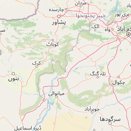
Map view of Kala Chitta National Park

Use this park location map to pinpoint Kala Chitta National Park in Pakistan, understand its exact geographic position, and read its mapped placement within the surrounding landscape more clearly.

Pigeon | © OpenStreetMap contributors

Location context for Kala Chitta National Park

Attock DistrictPunjab
Park atlas

Trace the geographic spread of protected landscapes and compare regional park diversity in Punjab.

Explore Adjacent National Parks and Protected Areas Near Kala Chitta National Park

Continue your park discovery from Kala Chitta National Park by exploring other protected areas throughout the Pothohar Plateau and the wider Punjab region. Browsing these adjacent national parks allows for direct comparison of their unique dry temperate forest ecosystems, diverse hill landscapes, and conservation values within this distinctive South Asian geography.
National parkPunjab
About 52 km away#1 closest

Southeast

Kheri Murat National Park: Protected Scrub Forest and Wildlife Conservation in Punjab

Explore the mapped terrain and protected landscape context.

Discover Kheri Murat National Park, a recent national park designation located in Punjab, Pakistan, situated on the rolling hills of the Kala Chitta Range. This protected area features a distinct subtropical thorn scrub forest ecosystem, providing essential habitat for wildlife, including the Punjab urial, and serving as a critical site for bird conservation. Its unique landscape offers valuable insights into regional geography and the preservation of natural wilderness within a predominantly agricultural province, making it a noteworthy entity for atlas exploration.

Area
35.37 km²
Established
2020
IUCN
II
Relief
Mountain
National parkIslamabad Capital Territory
About 59 km away#2 closest

East

Margalla Hills National Park: Pakistan's Gateway to Himalayan Foothills Geography

Mapped protected landscape with rich Sino-Himalayan biodiversity.

Margalla Hills National Park, situated in the Islamabad Capital Territory, serves as Pakistan's most accessible national park and a vital entry point to the Himalayan foothills. This protected landscape is defined by its rugged mountain terrain, ranging from lower scrublands to higher pine and oak woodlands, with elevations up to 1,604 meters. The park's geological significance, with ancient marine fossil formations, adds a unique dimension to its natural identity. Discover the mapped boundaries and ecological richness that characterize this important protected area, offering insights into regional geography and diverse habitats.

Area
173.86 km²
Established
1980
IUCN
V
Relief
Mountain
National parkPunjab
About 75 km away#3 closest

South

Chinji National Park: National Park Atlas, Salt Range Geography, and Protected Landscape

Discover the unique eroded terrain and semi-arid ecosystems of Punjab, Pakistan.

Chinji National Park is a protected national park located in the Punjab province of Pakistan, specifically within the historic Salt Range. This park is characterized by its deeply eroded terrain, composed of sandstone and igneous rock formations, shaped by seasonal streams that lead towards the Soan River. As a key example of a semi-arid mountain ecosystem within the Baluchistan xeric woodlands ecoregion, Chinji National Park offers significant insights into the geological heritage and unique biodiversity of central Pakistan.

Area
60.95 km²
Established
1987
IUCN
II
Relief
Upland
National parkKhyber Pakhtunkhwa
About 81 km away#4 closest

East

Ayubia National Park: Protected Area Identity and Mountainous Terrain

Discover its mapped geography within Khyber Pakhtunkhwa

Ayubia National Park stands as a key protected landscape within the Himalayan foothills of Khyber Pakhtunkhwa, Pakistan. Its designation as a national park signifies its role in conserving unique temperate coniferous and mixed forests across steep mountainous terrain. This page details the park's geographic setting, its mapped boundaries, and the natural features that define its protected status, offering a structured view for atlas-driven exploration of Pakistan's natural heritage.

Area
33.12 km²
Established
1984
IUCN
V
Visitors
250K annual
Protected areaKhyber Pakhtunkhwa
About 84 km away#5 closest

West

Tanda Dam Protected Area: Geographic Context and Wetland Map Features in Khyber Pakhtunkhwa

Ramsar-listed reservoir and regional irrigation landscape

Tanda Dam is a critical irrigation reservoir and Ramsar-listed wetland located in the Kohat District. This protected area supports agricultural networks for surrounding villages while serving as a winter refuge for migratory waterbirds traveling from the Caspian region and Siberia. The site offers a unique perspective on managed water landscapes within the broader terrain of Khyber Pakhtunkhwa.

Area
4.05 km²
Established
1967
Relief
Lowland
Scope
Terrestrial
National parkPunjab
About 108 km away#6 closest

East

Murree-Kotli Sattian-Kahuta National Park: Punjab Protected Landscape and Watershed

Western Himalayan foothills and Pothohar Plateau geography

Located in the Rawalpindi District, this national park preserves an extensive band of rugged terrain and chir pine forests. As a critical ecological bridge between neighboring protected areas, it provides essential habitat connectivity and maintains the health of river catchments that supply water to major urban centers in Punjab.

Area
473.7 km²
Established
2020
IUCN
II
Relief
Mountain
Wildlife reservePunjab
About 110 km away#7 closest

South

Chumbi Surla Wildlife Sanctuary: Geographic Overview of Punjab Foothill Habitats

Mapping protected scrub forests and ridges in Khushab and Chakwal

Covering thousands of acres of contiguous reserve forest, Chumbi Surla Wildlife Sanctuary represents a crucial protected ecosystem within the Punjab landscape. This high-altitude scrub environment provides an essential refuge for the Punjab urial, characterized by deep valleys, stony slopes, and ridge systems that define the topography of the local Salt Range outliers.

Area
226.4 km²
Established
1978
IUCN
IV
Relief
Upland
National parkPakistan
About 119 km away#8 closest

Southeast

Salt Range National Park: Pakistan's Protected Landscape for Geographic Atlas Exploration

Mapped boundaries and regional terrain context for a Pakistani national park.

Gain insight into Salt Range National Park, a significant national park established within Pakistan. This entry focuses on its role as a protected landscape, providing a mapped view of its geographic scope and environmental context. Understand how this park contributes to Pakistan's broader geography and offers opportunities for atlas-based discovery of its natural terrain.

Relief
Mountain
Scope
Terrestrial

Common questions about visiting, size, designation, and location context for Kala Chitta National Park

Kala Chitta National Park FAQs for park facts, access, geography, and protected area context

Find quick answers about Kala Chitta National Park, including protected-area facts, park geography, trail and visitor context, and how the park fits into its surrounding country and regional landscape.
MoriAtlas Explorer

Continue Your Protected Areas Search Across the Global Atlas

Deepen your exploration by continuing the structured search for national parks and protected areas worldwide. Utilize the comprehensive filtering capabilities to compare different conservation landscapes and refine your understanding of global park geography. Discover more about the distribution and characteristics of protected natural areas.

Global natural geography