

Mori Atlas logo
National parkKeep River National Park

Discover the mapped geography and protected landscape of this significant Top End protected area.

Keep River National Park: Northern Territory National Park with Dramatic Sandstone Landscapes

Keep River National Park stands as a key protected area within Australia's Northern Territory, spanning 574 square kilometers of striking natural beauty. This park is distinguished by its ancient sandstone formations, rugged gorges carved by the Keep River, and vital habitats critical for biodiversity. Its unique landscape context offers a profound connection to the region's geological past and Indigenous cultural heritage, making it a significant destination for atlas-based exploration.

Northern TerritorySandstone LandscapeIndigenous Rock ArtTop EndGouldian FinchesImportant Bird Area

Keep River National Park

National park

Park overview

Structured park overview, official facts, and landscape profile for Keep River National Park

Keep River National Park park facts, protected area profile, and essential visitor context

Review the core facts for Keep River National Park, including designation, size, terrain, visitor scale, habitats, and operating context in one park-focused overview.

About Keep River National Park

Keep River National Park occupies a significant position in the protected area network of Australia's Northern Territory, representing a blend of exceptional natural values and cultural heritage. The park's landscape is dominated by ancient sandstone formations that date back hundreds of millions of years, creating a terrain of considerable visual impact with gorges, cliffs, and scattered boulder fields. The Keep River, which gives the park its name, flows seasonally through the area, carving the prominent gorge that serves as one of the park's signature features. Beyond its geological significance, the park provides crucial habitat for biodiversity, particularly within the riparian zones and sandstone woodlands that support specialized flora and fauna. The establishment of the park in 1981 reflected growing recognition of the need to protect both the natural landscape and the Indigenous heritage sites within the area. Today, the park offers visitors an opportunity to experience the distinctive character of the Top End while learning about the enduring connection between Indigenous peoples and this ancient landscape.

Quick facts and research context for Keep River National Park

Keep River National Park covers an area of 574.37 square kilometers in the Northern Territory, established on 15 April 1981 under the management of the Parks and Wildlife Commission of the Northern Territory. The nearest population center is Kununurra in Western Australia, located approximately 468 kilometers to the west. The park features striking sandstone formations throughout, with the most notable geological feature being Keep River Gorge where an Indigenous rock art site is located. The park falls within the Keep River Important Bird Area, recognized internationally for its significance to endangered bird species. Annual visitation reaches approximately 23,200 visitors, with access sometimes restricted during the wet season due to flooding.

Protection and recognition

Verifying terrestrial conservation history and official reserve framework since establishment in 1981.

Keep River National Park Protection Status and Terrestrial Designation

Geographic records trace the official establishment of Keep River National Park as a dedicated terrestrial protected area dating back to its designation in 1981. Reviewing verified management parameters provides critical context on the regional conservation framework and the structured status of northern Australian landscapes.

Protection details

Protection scope
Terrestrial
Designated year
1981
Transboundary protection
No
Park context

Deeper park guide and search-rich context for Keep River National Park

Keep River National Park history, landscape, wildlife, and travel context

Explore Keep River National Park through its history, landscape character, ecosystems, wildlife, conservation priorities, cultural context, and seasonal travel timing in a structured park guide built for atlas discovery and search intent.

Why Keep River National Park stands out

Keep River National Park is best known for its remarkable sandstone landscape, which features dramatic cliffs, monolithic formations, and the scenic Keep River Gorge. The park contains significant Indigenous Australian rock art at the end of the gorge walk, providing a tangible connection to the cultural heritage of the Mirriwung and Gadjerong peoples. The park is also recognized as a critical habitat for the endangered Gouldian finch, one of Australia's most colorful and ecologically restricted bird species. The contrast between the rugged sandstone terrain and the riparian corridors along the Keep River creates a distinctive Top End landscape that distinguishes this park from other Northern Territory protected areas.

Keep River National Park history and protected-area timeline

Keep River National Park was officially established on 15 April 1981, representing a significant addition to the Northern Territory's protected area network during a period of increased conservation awareness in Australia. The park's creation recognized both the outstanding natural values of the sandstone landscape and the cultural significance of the area to Indigenous communities. Prior to formal protection, the land had been part of traditional Country for the Mirriwung and Gadjerong peoples, who maintain cultural connections to the landscape spanning countless generations. The management of the park falls to the Parks and Wildlife Commission of the Northern Territory, which works to balance visitor access with conservation outcomes and respect for Indigenous heritage values. Over the decades, the park has maintained its protective status while gradually developing visitor infrastructure to support sustainable tourism in the region.

Keep River National Park landscape and geographic character

The landscape of Keep River National Park is defined by its dramatic sandstone terrain, which forms the most visually distinctive element of the protected area. Ancient sandstone formations rise from the surrounding terrain, creating a series of cliffs, ridges, and boulder-strewn slopes that have been sculpted by natural forces over geological time. The Keep River Gorge cuts through these sandstone formations, providing a scenic corridor where visitors can experience the interplay between water, rock, and vegetation. The river itself flows seasonally, with flow patterns tied to the monsoonal climate of the Top End. Beyond the gorge, the park encompasses a mix of open woodlands, riparian corridors, and sandstone pavements, creating a mosaic of habitats that reflects the underlying geology and the influence of the wet-dry tropical climate. The visual contrast between the red-orange hues of the sandstone and the green vegetation along watercourses creates a landscape of considerable aesthetic appeal.

Keep River National Park ecosystems, habitats, and plant life

The natural environment of Keep River National Park reflects the ecological characteristics of the Top End region, supporting a mix of habitats that include sandstone woodlands, riparian forests, and open savanna. The park lies within the Keep River Important Bird Area, an internationally recognized site that has been identified for its significance to bird conservation. This designation reflects the presence of specialized habitats that support bird species adapted to the unique conditions of the sandstone landscape. The riparian corridors along the Keep River provide important habitat for wildlife, offering water and shelter in an environment where seasonal conditions can be extreme. The sandstone formations themselves harbor specialized plant species adapted to the rocky substrate and seasonal moisture patterns. The intersection of tropical and arid influences creates an ecological character that is distinctive to the Top End region.

Keep River National Park wildlife and species highlights

Keep River National Park provides habitat for several notable wildlife species, with particular significance attached to the presence of the endangered Gouldian finch. This colorful bird, one of Australia's most distinctive finch species, depends on the specific habitat conditions found within the Important Bird Area for its survival. The park's mix of woodlands, grass plains, and riparian zones supports a range of other bird species, while the sandstone formations and river corridors provide shelter for mammals, reptiles, and insects adapted to the Top End environment. The seasonal nature of the landscape, with wet and dry periods influencing animal behavior and distribution, creates dynamic wildlife viewing opportunities for visitors. While comprehensive species lists are not the focus of this profile, the park clearly supports biodiversity of conservation significance, particularly for birds.

Keep River National Park conservation status and protection priorities

The conservation significance of Keep River National Park is underscored by its inclusion within the Keep River Important Bird Area, an officially recognized site of international importance for bird conservation. This designation specifically recognizes the park's role in supporting populations of the endangered Gouldian finch, a species that has suffered significant population declines across its range. The protection of this habitat represents a critical component of broader conservation efforts for the species. Beyond avifauna, the park conserves representative examples of Top End ecosystems, including sandstone woodlands and riparian environments that would otherwise be vulnerable to change. The presence of Indigenous cultural values, including rock art sites, adds another dimension to the conservation values of the area, as these sites require protection as part of the broader cultural landscape.

Keep River National Park cultural meaning and human context

Keep River National Park encompasses cultural landscape values that extend beyond its natural features, carrying deep significance for the Mirriwung and Gadjerong peoples who have maintained continuous connection to this Country for thousands of years. The park contains Indigenous Australian rock art at the end of the Keep River Gorge walk, providing evidence of long-term human presence and cultural practices in the area. These rock art sites represent significant heritage values that require careful management and respect. The broader landscape within the park boundaries falls within the traditional tribal area of the Mirriwung and Gadjerong peoples, acknowledging the ongoing Indigenous connection to the land even after the establishment of the protected area. This cultural context adds meaningful dimension to the park's identity, integrating natural and cultural heritage in a way that reflects the holistic values of Indigenous land management.

Top sights and standout views in Keep River National Park

Keep River National Park offers several standout features that distinguish it within the Northern Territory's protected area network. The sandstone formations and Keep River Gorge represent the park's most visually dramatic landscapes, providing excellent opportunities for walking and photography. The Indigenous rock art site at the end of the gorge walk offers a direct connection to the cultural heritage of the Mirriwung and Gadjerong peoples. The park's status as critical habitat for the endangered Gouldian finch makes it particularly significant for birdwatching enthusiasts and conservation-minded visitors. The seasonal character of the landscape, with wet and dry seasons creating different visitor experiences, adds depth to the park's appeal as a destination for understanding Top End environments.

Best time to visit Keep River National Park

The optimal time to visit Keep River National Park is during the dry season months from May to August, when visitor access is most reliable and conditions are most comfortable. During this period, temperatures range from a minimum of around 10°C to a maximum of approximately 35°C, providing pleasant conditions for outdoor activities compared to the hotter wet season. The dry season also means that access roads remain open and visitor facilities are fully accessible, unlike the wet season when flooding can restrict movement through the park. Visitors planning trips should be aware that the wet season typically brings heavy rainfall and potential road closures, making the May to August window the most practical choice for most visitors. The seasonal variation in landscape appearance between wet and dry periods also offers different experiences depending on when one visits, with the dry season often presenting more accessible and scenic conditions.
Monthly climate preview

Long-term monthly temperature averages and precipitation patterns for Keep River National Park

Keep River National Park Climate Normals, Annual Temperature and Precipitation Records

Representative coordinate records show measured monthly temperature variations alongside shifting precipitation patterns across the protected landscape. Examining the full twelve-month profile reveals detailed baseline climate normals and long-term meteorological trends.
Annual mean28 °C
23 °C32 °C
Jan29°
Feb28°
Mar28°
Apr27°
May25°
Jun23°
Jul23°
Aug25°
Sep29°
Oct32°
Nov32°
Dec31°
Warmest month
November

32.3 °C

Coolest month
June

22.9 °C

Wettest month
February

8.4 mm/day

Driest month
August

0 mm/day

Park location guide

Geography guide, regional context, and park location map for Keep River National Park

Keep River National Park park geography, regions, and map view in Australia

Understand where Keep River National Park sits in Australia through a broader geographic reading of the surrounding landscape, nearby location context, and its mapped position within the national park landscape.

How Keep River National Park fits into Australia

Australia is a constitutional monarchy and federal parliamentary democracy comprising six states and ten territories. With a population of nearly 28 million, it is one of the world's most urbanised countries, with most people concentrated on the eastern seaboard. The country has a high Human Development Index and is known for its cultural diversity, ancient Aboriginal heritage, and unique wildlife.

Wider geography shaping Keep River National Park in Australia

Australia occupies the entire Australian continent, the island of Tasmania, and numerous smaller islands. It is the world's flattest and driest inhabited continent, featuring vast deserts in the interior (the Outback), tropical rainforests along the eastern coast, and a coastline bordering the Indian and Pacific Oceans.

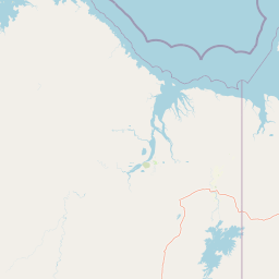
Map view of Keep River National Park

Use this park location map to pinpoint Keep River National Park in Australia, understand its exact geographic position, and read its mapped placement within the surrounding landscape more clearly.

Pigeon | © OpenStreetMap contributors

Location context for Keep River National Park

Northern Territory
Recorded earthquake history

Examine Recorded Earthquake History Near Keep River National Park

Explore a curated catalogue of historical seismic events linked to Keep River National Park by proximity. MoriAtlas provides this data for geographic context, enabling users to review recorded earthquake history in the Northern Territory through mapped epicentres and verified event metrics.

Keep River National Park Earthquake History

Catalogued events

2 events

Strongest magnitude

Magnitude 4.3

Most recent event

Feb 20, 2019

This history includes earthquakes recorded inside the park or within 50 km of its borders

Park atlas

Compare the diverse sandstone landscapes and conservation efforts of Australia's Top End region.

Discover Nearby National Parks and Protected Areas Surrounding Keep River National Park

Explore other national parks and protected areas near Keep River National Park, tracing the regional spread of Top End sandstone landscapes and critical conservation habitats. Compare geological formations, Indigenous cultural sites, and distinct biodiversity across these protected regions to deepen your atlas-style understanding of Australian conservation.
National parkWestern Australia
About 25 km away#1 closest

West

Mirima National Park: Exploring Its Protected Landscape and Regional Geography in Western Australia

Discover mapped boundaries and the national park's place in regional context.

Mirima National Park is a significant protected area offering insights into the natural landscapes of Western Australia. This page provides a detailed view of its protected landscape identity and its geographic position within the larger atlas of Australian conservation lands. Explore the mapped boundaries and understand how Mirima National Park contributes to the regional geography and the broader framework of protected areas.

Area
20.68 km²
Established
1982
IUCN
II
Access
Easy access
Watercolor illustration showing rolling green hills, a red rock formation, and scattered trees
National parkNorthern Territory
73 km away#2 closest

East

Judbarra National Park: Northern Territory National Park Protected Landscape and Geography

Discover its mapped terrain and ancient Indigenous rock art.

Judbarra National Park is a major national park in Australia's Northern Territory, recognized for its extensive Indigenous rock art, which constitutes a significant artistic province. Spanning a vast area with two distinct geographic sections, the park showcases a transition between tropical and semi-arid ecosystems. Users can explore its rugged terrain, sandstone escarpments, and mapped park boundaries to understand its unique regional geographic context and rich cultural heritage.

Area
13,004.1 km²
Established
1990
IUCN
II
Relief
Mixed relief
National parkWestern Australia
133 km away#3 closest

South

Purnululu National Park: National Park Atlas and Mapped Protected Landscape

Explore Western Australia's Purnululu National Park geography.

Gain a structured atlas-style understanding of Purnululu National Park, a key protected area in Western Australia. This page details the park's geographic identity, its role as a national park, and its relationship to the surrounding regional landscapes. Engage with mapped park boundaries and factual context to appreciate its place in the broader Australian conservation geography.

Area
2,397.23 km²
Established
1987
IUCN
II
Relief
Mountain
Nature reserveWestern Australia
About 196 km away#4 closest

Southwest

Marion Downs Sanctuary: Protected Kimberley Nature Reserve and Tropical Savanna Map

Explore conservation geography and sandstone terrain in Western Australia.

Marion Downs Sanctuary is a expansive nature reserve located in the heart of the Kimberley region of Western Australia. The protected territory includes vast tropical savanna woodlands and rugged sandstone gorges linked to the Fitzroy River system. Gain insights into the mapped boundaries and natural terrain that make this location a vital refuge for diverse species within the broader Australian outback.

Area
2,890 km²
Established
2008
Relief
Upland
Climate
Tropical
National parkWestern Australia
197 km away#5 closest

West

Drysdale River National Park: Western Australia National Park Geographic Atlas Entry

Mapped protected landscape and regional context.

Delve into the protected landscape of Drysdale River National Park, a designated national park located in Western Australia. This page serves as a focused entry point for understanding its geographic placement, mapped boundaries, and contribution to the broader regional atlas. Explore the specific terrain and protected area context of Drysdale River National Park, aiding in structured geographic discovery within Australia's vast natural areas.

Area
4,482.64 km²
Established
1974
IUCN
II
Relief
Mountain
National parkNorthern Territory
About 241 km away#6 closest

Northeast

Fish River Station National Park: Protected Landscapes and Geographic Atlas

Indigenous-managed conservation in the Northern Territory

Fish River Station serves as a critical conservation block south of Darwin, featuring a distinctive blend of riverine floodplains, billabongs, and rugged upland ranges. Its protected boundaries preserve a wide array of tropical habitats, highlighting the intersection of traditional land management and large-scale environmental preservation within the Australian National Reserve System.

Area
1,781 km²
Established
2010
IUCN
II
Relief
Mixed relief
Nature reserveNorthern Territory
About 271 km away#7 closest

Northeast

Giwining / Flora River Nature Park: Protected Limestone Landscapes of Northern Territory

Geological spring systems and tropical riverine corridors.

The landscape of Giwining / Flora River Nature Park is defined by a network of calcium-rich springs emerging from Tindall Limestone. These waters have sculpted tufa dams and cascading waterfalls along the Flora River, creating a unique geological environment within the savanna woodlands of the Northern Territory.

Area
78.24 km²
Established
1993
IUCN
V
Relief
Lowland
National parkNorthern Territory
294 km away#8 closest

Northeast

Litchfield National Park: Northern Territory National Park Protected Landscape Atlas

Explore regional geography and mapped park boundaries.

Litchfield National Park is a protected natural area located in Australia's Northern Territory, designated as a national park. This page offers detailed geographic context and explores the park's mapped boundaries, providing a foundational understanding of its protected landscape identity. Discover how Litchfield National Park fits within the broader atlas of Australian conservation lands, highlighting its regional geographic significance and mapped terrain.

Area
1,458.47 km²
Established
1991
IUCN
II
Visitors
329.6K annual

Common questions about visiting, size, designation, and location context for Keep River National Park

Keep River National Park FAQs for park facts, access, geography, and protected area context

Find quick answers about Keep River National Park, including protected-area facts, park geography, trail and visitor context, and how the park fits into its surrounding country and regional landscape.
MoriAtlas Explorer

Continue Your Protected Areas Search Across the Global Atlas

Deepen your exploration by continuing the structured search for national parks and protected areas worldwide. Utilize the comprehensive filtering capabilities to compare different conservation landscapes and refine your understanding of global park geography. Discover more about the distribution and characteristics of protected natural areas.

Global natural geography