Mori Atlas logo
National parkKhustain Nuruu National Park

Discover the mapped geography and conservation focus of this key Mongolian national park.

Khustain Nuruu National Park: Mongolia's Protected Steppe Landscape & Przewalski's Horse Sanctuary

Khustain Nuruu National Park stands as a critical protected area within Mongolia, recognized for its significant role in the successful reintroduction of the Przewalski's horse, or takhi. This national park preserves the distinctive mountainous steppe terrain of the region, offering a vital habitat for a variety of wildlife. As a cornerstone of conservation in Central Asia, Khustain Nuruu provides essential insights into grassland ecosystems and the resilience of species driven to extinction in the wild.

Mongoliasteppe wildernessPrzewalski's horsetakhi conservationCentral Asiaprotected area

Khustain Nuruu National Park

National park

Park overview

Structured park overview, official facts, and landscape profile for Khustain Nuruu National Park

Khustain Nuruu National Park park facts, protected area profile, and essential visitor context

Review the core facts for Khustain Nuruu National Park, including designation, size, terrain, visitor scale, habitats, and operating context in one park-focused overview.

About Khustain Nuruu National Park

Khustain Nuruu National Park is a protected natural area located in Mongolia, situated in the mountainous steppe region of the country. The park is renowned for its successful conservation efforts centered on the reintroduction of the Przewalski's horse, also known as the takhi, which was reintroduced to the wild in these lands after being extinct in Mongolia for decades. The park encompasses diverse steppe landscapes, rolling hills, and forested mountain valleys that provide habitat for a variety of Mongolian wildlife species. As one of Mongolia's smaller protected areas, Khustain Nuruu represents a significant conservation success story and offers visitors the opportunity to experience the unique ecology of the Mongolian steppe.

Quick facts and research context for Khustain Nuruu National Park

Khustain Nuruu National Park is located in the central steppe region of Mongolia, within the Khentii Mountains area. The park is most famous for its population of Przewalski's horses, the only true wild horse species remaining in the world. The protected area features a mix of grassland steppe, forested slopes, and river valleys. It was established as a protected area in 1993 as part of broader conservation initiatives to restore Mongolia's endangered wildlife populations.

Protection and recognition

Terrestrial conservation boundaries and formal protection frameworks for Mongolian landscapes

Khustain Nuruu National Park Protection Status and Designation

Khustain Nuruu National Park operates under a documented terrestrial protection status established to safeguard its native geography and ecological integrity. Database records verify the official boundaries and conservation framework details to support geographic research and comparative land management analysis.

Protection details

Protection scope
Terrestrial
Transboundary protection
No
Park context

Deeper park guide and search-rich context for Khustain Nuruu National Park

Khustain Nuruu National Park history, landscape, wildlife, and travel context

Explore Khustain Nuruu National Park through its history, landscape character, ecosystems, wildlife, conservation priorities, cultural context, and seasonal travel timing in a structured park guide built for atlas discovery and search intent.

Why Khustain Nuruu National Park stands out

Khustain Nuruu National Park is best known as the site of the successful reintroduction of the Przewalski's horse, or takhi, to its natural habitat. This conservation achievement represents one of the most remarkable wildlife recovery stories in Asia, as the species was driven to extinction in the wild in Mongolia during the 1960s. The park provides protected habitat for these horses and offers one of the few places in the world where visitors can observe the last truly wild horse species in its natural steppe environment.
Monthly climate preview

Monthly temperature ranges and precipitation averages from representative coordinate data

Khustain Nuruu National Park Climate Normals and Temperature Patterns

Representative coordinates record long term temperature and precipitation cycles across twelve distinct months for Khustain Nuruu National Park. Complete monthly climate profiles examine detailed thermal variations and precipitation shifts in greater depth.
Annual mean0 °C
-20 °C19 °C
Jan-20°
Feb-15°
Mar-6°
Apr
May10°
Jun16°
Jul19°
Aug17°
Sep
Oct
Nov-10°
Dec-17°
Warmest month
July

19.2 °C

Coolest month
January

-19.6 °C

Wettest month
July

2.1 mm/day

Driest month
January

0.1 mm/day

Park location guide

Geography guide, regional context, and park location map for Khustain Nuruu National Park

Khustain Nuruu National Park park geography, regions, and map view in Mongolia

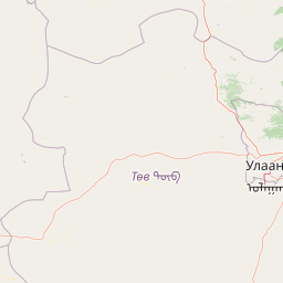
Understand where Khustain Nuruu National Park sits in Mongolia through a broader geographic reading of the surrounding landscape, nearby location context, and its mapped position within the national park landscape.

How Khustain Nuruu National Park fits into Mongolia

Mongolia is a landlocked sovereign state in East Asia, known for its vast steppe landscapes, nomadic culture, and historical significance as the heartland of the Mongol Empire founded by Genghis Khan in 1206. The country has a population of approximately 3.5 million people and is the world's most sparsely populated sovereign state. Ulaanbaatar is the capital and largest city, home to roughly half the population.

Wider geography shaping Khustain Nuruu National Park in Mongolia

Mongolia is located in East Asia, landlocked between Russia to the north and China to the south. The country occupies the Mongolian Plateau and features diverse terrain including grassy steppe, mountains in the north and west, and the Gobi Desert in the south. It covers 1,564,116 km2, making it the second largest landlocked country in the world.

Map view of Khustain Nuruu National Park

Use this park location map to pinpoint Khustain Nuruu National Park in Mongolia, understand its exact geographic position, and read its mapped placement within the surrounding landscape more clearly.

Pigeon | © OpenStreetMap contributors
Park atlas

Trace the regional protected landscapes and compare adjacent steppe wilderness areas near Khustain Nuruu National Park in Central Asia.

Discover Other National Parks and Protected Areas Near Khustain Nuruu National Park in Mongolia

Explore other protected areas and national parks that share the unique steppe wilderness and conservation challenges found around Khustain Nuruu National Park. Compare their mapped geography and discover the broader network of reserves preserving Mongolia's diverse grassland and mountainous ecosystems.
National parkTöv Province
About 0.4 km away#1 closest

Hustai National Park: Geographic and Protected Landscape Profile in Töv Province

Steppe, mountain, and riverine ecosystem mapping

Hustai National Park serves as a landmark conservation site in Töv Province, protecting a distinct gradient between the Khustai mountain ridges and the surrounding Mongolian plains. The area is defined by its role in steppe ecology, featuring varied slopes, riverine woodlands, and expansive grasslands that support a unique assembly of wildlife within the broader central Mongolian region.

Area
506 km²
Established
2003
IUCN
II
Relief
Mountain
Biosphere reserveUlaanbaatar
About 83 km away#2 closest

East

Bogd Khan Uul Biosphere Reserve: Mapped Protected Landscapes and Geographic Overview

Highland ecosystems and forest steppe in the Khentii Mountains.

Rising directly south of Ulaanbaatar, Bogd Khan Uul Biosphere Reserve protects a compact mosaic of habitats including larch forests, Siberian pine stands, and alpine rock. The reserve serves as a critical geographic marker, illustrating the rapid shift from urban fringes to subalpine wilderness while maintaining a history of sacred environmental protection that informs its current status as a biosphere reserve.

Area
673 km²
Established
1996
Relief
Mountain
Climate
Boreal
National parkTöv Province
About 134 km away#3 closest

East

Gorkhi-Terelj National Park: Mapped Protected Landscape in Töv Province

Explore the geographic context and park boundaries.

Gorkhi-Terelj National Park is a designated national park offering rich opportunities for geographic exploration and protected landscape discovery. This entity page provides detailed insights into its mapped boundaries and its position within the regional geography of Töv Province. Understand the specific landform and terrain characteristics that define this protected natural area, central to understanding Mongolia's conservation landscapes.

Area
2,920 km²
Established
1993
IUCN
II
Relief
Mountain
National parkMongolia
About 171 km away#4 closest

West

Khogno Khan National Park: A National Park with Distinct Mongolian Landscape Identity

Explore its mapped terrain and regional geographic context.

Khogno Khan National Park is a designated national park offering a specific focus for protected landscape discovery. Users can explore its geographic placement within Mongolia and understand its role as a mapped natural area. The park's identity as a protected territory provides critical context for those interested in the atlas of East Asian landscapes and regional geography, highlighting a distinct area for geographic study.

Area
841 km²
Established
2003
IUCN
II
Relief
Mountain
Protected areaArkhangai Province
About 233 km away#5 closest

West

Ögii Lake Protected Area: A Comprehensive Geographic Overview of the Mongolian Steppe

Freshwater basin and wetland geography in Arkhangai Province

Ögii Lake represents a pivotal protected landscape in central Mongolia, defined by its 25 square kilometer surface area and gentle, shallow underwater topography. This site functions as an ecological nexus for migratory waterbirds and is essential for understanding the transition between open grassland and the mountainous terrain of the Khangai region.

Area
25.7 km²
Established
2006
Relief
Lowland
Access
Access unknown
Wildlife reserveKhentii Province
About 239 km away#6 closest

Northeast

Khan Khentii Strictly Protected Area: Geographic Overview and Protected Landscape Mapping

Eastern Mongolia wilderness and Khentii mountain terrain

Explore the expansive reaches of Khan Khentii Strictly Protected Area, a cornerstone of Mongolian conservation. This reserve shields intact taiga forests, river valley habitats, and the historic Burkhan Khaldun mountain from industrial activity, preserving one of the most significant mountain wilderness regions in the province of Khentii.

Area
12,270 km²
Established
1992
IUCN
Ib
Relief
Mountain
Nature reserveDornogovi Province
About 323 km away#7 closest

Southeast

Ikh Nartiin Chuluu Nature Reserve: Mapping Granite Outcrops and Steppe in Dornogovi Province

A vital protected sanctuary within the Mongolian Gobi desert landscape

Ikh Nartiin Chuluu Nature Reserve occupies a unique position in the Dornogovi Province of Mongolia, where granite skeletons meet arid plains. The protected area serves as a significant biological stronghold, offering a detailed study of how rocky crevices and sheltered valleys support diverse steppe life. Use this atlas resource to understand the park boundaries, terrain features, and regional landscape context that make this reserve a reference site for desert conservation.

Area
660 km²
Established
1996
Relief
Upland
Climate
Arid
National parkMongolia
About 343 km away#8 closest

West

Khangai Nuruu National Park: Discover Mongolia's Protected Mountain Landscape and Atlas Context

Explore mapped boundaries and diverse ecosystems across its terrain.

Khangai Nuruu National Park stands as a vast national park in central Mongolia, characterized by its diverse protected landscapes and significant geographic scope. Spanning the Khangai Mountains, it presents a remarkable ecological transition from alpine meadows and taiga forests to steppe and riparian environments. This park offers a rich atlas exploration opportunity, highlighting its mapped boundaries and the unique regional geography that defines its protected status, making it a key point of discovery for understanding Mongolian conservation areas.

Area
8,885 km²
Established
1996
IUCN
II
Relief
Mountain

Common questions about visiting, size, designation, and location context for Khustain Nuruu National Park

Khustain Nuruu National Park FAQs for park facts, access, geography, and protected area context

Find quick answers about Khustain Nuruu National Park, including protected-area facts, park geography, trail and visitor context, and how the park fits into its surrounding country and regional landscape.
MoriAtlas Explorer

Continue Your Protected Areas Search Across the Global Atlas

Deepen your exploration by continuing the structured search for national parks and protected areas worldwide. Utilize the comprehensive filtering capabilities to compare different conservation landscapes and refine your understanding of global park geography. Discover more about the distribution and characteristics of protected natural areas.

Global natural geography