

Mori Atlas logo
National parkLar National Park

Discover the mapped boundaries and alpine terrain at the southern flank of Mount Damavand.

Lar National Park: National Park, Protected Landscape Atlas, and Alpine Geography

Lar National Park represents a significant protected landscape within Iran's Mazandaran Province, offering a detailed view of alpine and sub-alpine terrain. Situated within the Central Alborz mountain range, adjacent to Mount Damavand, this national park's geographic context is defined by its dramatic topography and ecological transition. Users can explore the park's mapped protected area, understand its unique position in the Caspian basin, and appreciate its role as a key conservation landscape.

Alpine mountainsProtected areaBrown bear habitatSalmonid fishAlborz rangeDamavand

Lar National Park

National park

Park overview

Structured park overview, official facts, and landscape profile for Lar National Park

Lar National Park park facts, protected area profile, and essential visitor context

Review the core facts for Lar National Park, including designation, size, terrain, visitor scale, habitats, and operating context in one park-focused overview.

About Lar National Park

Lar National Park occupies a significant position in Iran's network of protected areas, guarding a substantial tract of the Central Alborz mountain landscape at the interface between the Caspian Sea basin and the interior highlands. The park's setting at the foot of Mount Damavand places it within view of Iran's most iconic mountain, while the Lar Dam provides a prominent water body that shapes the local ecology and landscape character. The Alborz mountains form a natural barrier between the humid Caspian coast and the drier central plateau, creating environmental gradients that support diverse habitats within relatively compact geographic areas. As a national park designated in 1976, Lar represents an early entry in Iran's modern protected area system, with subsequent enhancements to its protected status and management framework. The park's accessibility via Haraz Road, a major route connecting Tehran to the Caspian coastal region, makes it one of the more reachable mountain protected areas for visitors traveling from the capital.

Quick facts and research context for Lar National Park

Lar National Park covers roughly 30,000 hectares in the Central Alborz range, positioned at the foot of 5,609-meter Mount Damavand. The protected area was formally established in 1976, with additional protected status granted in 1982, and hunting has been prohibited since 1991. The Lar Dam and its reservoir lie within the park boundaries, and the area is accessible via Haraz Road (Road 77), which connects the Mazandaran coastal region to Tehran. The park lies in Amol County, Mazandaran Province, approximately 150 kilometers northeast of Tehran.

Protection and recognition

Exploring terrestrial boundaries and historical designation frameworks established in 1982.

Documented Protection Status and Legal Designation of Lar National Park

National park database records outline the formal terrestrial protection status and conservation history of Lar National Park. Verifying documented designation years and regional management parameters provides clear structural context for exploring individual protected areas.

Protection details

Protection scope
Terrestrial
Designated year
1982
Transboundary protection
No
Park context

Deeper park guide and search-rich context for Lar National Park

Lar National Park history, landscape, wildlife, and travel context

Explore Lar National Park through its history, landscape character, ecosystems, wildlife, conservation priorities, cultural context, and seasonal travel timing in a structured park guide built for atlas discovery and search intent.

Why Lar National Park stands out

Lar National Park is best known for its dramatic position at the southern flanks of Mount Damavand, placing it in one of the most visually commanding alpine settings in Iran. The park provides protected habitat for notable species including the Syrian brown bear, one of the rarest bear subspecies in the world, and supports populations of salmonid fish species that represent rare survivors in Iran's freshwater systems. The combination of proximity to Iran's highest mountain, the presence of a significant reservoir, and the protection of relatively intact alpine ecosystems gives the park its distinctive conservation character.

Lar National Park history and protected-area timeline

Lar National Park was established in 1976 as part of Iran's developing national park system, representing an early effort to designate meaningful conservation areas in the country's mountainous northern regions. In 1982, the Iran Department of Environment expanded the protective framework by formally designating the area as a protected area, strengthening regulatory oversight of land use and resource exploitation. A significant milestone in the park's conservation history came in 1991, when hunting was prohibited throughout the protected area, providing formal legal protection for wildlife populations. The construction and presence of Lar Dam within the park boundaries has influenced the landscape and ecology of the area, creating a reservoir that now forms a distinctive feature of the park's geography. These institutional developments reflect Iran's broader efforts to balance conservation with development pressures in environmentally sensitive mountain regions.

Lar National Park landscape and geographic character

The landscape of Lar National Park is defined by its position in the Central Alborz, a mountain range that runs parallel to Iran's southern Caspian coast. The terrain rises from the park's lower elevations toward the massive bulk of Mount Damavand, whose perpetually snow-capped summit dominates the visual horizon from within the protected area. Steep-walled valleys, rocky ridgelines, and alpine meadows characterize the park's topography, with the elevation gradient creating noticeable changes in vegetation and terrain over relatively short horizontal distances. The Lar Dam reservoir adds a significant impounded water body to the landscape, creating a flat-water environment amid the surrounding mountain terrain. The interplay between the dam, the mountain backdrop, and the varying alpine terrain gives the park a diverse visual character within a relatively compact area.

Lar National Park ecosystems, habitats, and plant life

The natural environment of Lar National Park reflects the transitional ecological position between the Caspian coastal plain and the interior highlands of Iran. The Alborz mountains support distinct altitudinal zonation in vegetation, with lower slopes carrying forest cover that transitions to alpine meadows and rocky terrain at higher elevations. The presence of salmonid fish in the park's waters represents particular ecological significance, as these cold-water species require specific habitat conditions that are limited in Iran's otherwise arid to semi-arid freshwater systems. The protection of this habitat within a national park context helps preserve genetic populations of these fish that are otherwise rare in the region. The alpine and sub-alpine environments support characteristic high-elevation plant communities adapted to the harsh conditions of the Alborz.

Lar National Park wildlife and species highlights

Lar National Park provides habitat for several notable species, with the Syrian brown bear representing one of the most significant wildlife inhabitants. This bear subspecies is among the rarest in the world, and the protected status of Lar National Park contributes to conservation of populations in the Alborz mountains. The park's water bodies support populations of salmonid fish, members of the Salmonidae family that are native to the area and represent rare freshwater fish diversity in Iran. These species depend on the cold, well-oxygenated waters of the mountain streams and the Lar reservoir, making the protection of these aquatic habitats important for their survival. The combination of terrestrial and aquatic habitats within the protected area supports a complement of species adapted to the challenging alpine environment.

Lar National Park conservation status and protection priorities

Lar National Park serves as an important conservation unit within Iran's protected area network, safeguarding representative examples of Alborz mountain ecosystems. The dual designation as both a national park since 1976 and a protected area since 1982 provides layered regulatory protection for the landscape and its wildlife. The prohibition of hunting since 1991 addresses one of the primary pressures on wildlife populations in mountain environments. Protection of the salmonid fish populations represents a particular conservation priority, as these species are rare in Iran's freshwater environments. The park's position guarding the lower slopes of Mount Damavand also contributes to watershed protection for downstream areas including the Lar reservoir.

Lar National Park cultural meaning and human context

The Alborz mountains have long been part of the cultural landscape of northern Iran, with mountain communities and traditional land uses shaping the region's heritage. The Mazandaran Province, where Lar National Park is located, has its own distinct cultural identity reflecting the Caspian coastal and mountain environments. While the park itself focuses on conservation of natural values, the surrounding region carries historical significance as part of the traditional territory of Persian and earlier civilizations. The Haraz Road corridor, which provides access to the park, has been a travel route between the interior and coast for generations.

Top sights and standout views in Lar National Park

Lar National Park offers a distinctive combination of alpine mountain scenery focused on the imposing presence of Mount Damavand, protected wildlife including the rare Syrian brown bear, and the unique salmonid fish populations in its waters. The Lar reservoir adds a significant aquatic element to the park's character, creating a landscape feature that is uncommon in Iran's mountain protected areas. The park's location along a major travel corridor makes it relatively accessible for those visiting from Tehran, while its protected status since 1976 reflects its long-standing recognition as a significant conservation area in the Alborz.

Best time to visit Lar National Park

The best time to visit Lar National Park depends on the experience sought. Summer months offer the most accessible conditions for exploring the park's trails and higher-elevation areas, with warmer temperatures and generally stable weather in the mountain environment. Spring brings blooming alpine meadows and flowing water from snowmelt, while autumn offers clear skies and the opportunity to experience the transition of the landscape into fall colors. Winter conditions in the Alborz can be severe, with heavy snow and cold temperatures limiting access to higher areas, though the mountain scenery takes on a different character for those who venture into the park during the colder season.

Monthly climate preview

Long term temperature and precipitation records measured at representative park elevations

Lar National Park Climate Normals and Monthly Weather Patterns

Lar National Park exhibits a measured annual temperature and precipitation rhythm across representative coordinate points, spanning subzero winter conditions and warm summer maximums. Examining weather by month through complete climatological records provides detailed context on long term averages and seasonal shifts.
Annual mean8 °C
-5 °C20 °C
Jan-5°
Feb-4°
Mar
Apr
May12°
Jun17°
Jul20°
Aug19°
Sep15°
Oct
Nov
Dec-3°
Warmest month
July

20 °C

Coolest month
January

-5.3 °C

Wettest month
November

2.3 mm/day

Driest month
June

0.4 mm/day

Park location guide

Geography guide, regional context, and park location map for Lar National Park

Lar National Park park geography, regions, and map view in Iran

Understand where Lar National Park sits in Iran through a broader geographic reading of the surrounding landscape, nearby location context, and its mapped position within the national park landscape.

How Lar National Park fits into Iran

Iran is a West Asian nation with a population exceeding 92 million, making it the 17th most populous country globally. It borders seven countries and has coastlines along the Caspian Sea, Persian Gulf, and Gulf of Oman. Tehran is the capital and largest city, while Persian is the official language.

Wider geography shaping Lar National Park in Iran

Iran occupies a strategic position in West Asia, bordering Iraq to the west, Turkey, Azerbaijan, and Armenia to the northwest, Turkmenistan to the northeast, Afghanistan to the east, and Pakistan to the southeast. It has coastlines along the Caspian Sea to the north, the Persian Gulf to the south, and the Gulf of Oman to the southeast. The terrain includes mountain ranges such as the Zagros and Alborz, as well as arid desert areas.

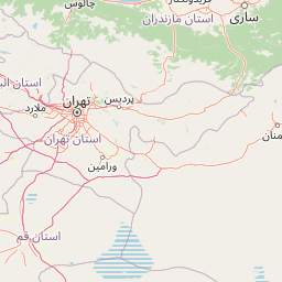
Map view of Lar National Park

Use this park location map to pinpoint Lar National Park in Iran, understand its exact geographic position, and read its mapped placement within the surrounding landscape more clearly.

Pigeon | © OpenStreetMap contributors

Location context for Lar National Park

Mazandaran Province
Park atlas

Trace connected protected landscapes and mountain wilderness across the Central Alborz range.

Discover More National Parks and Protected Areas Near Lar National Park in Iran

Browse additional national parks and protected areas near Lar National Park, spanning the rugged alpine terrain of the Central Alborz mountain range and adjacent conservation landscapes. This geographic context allows for detailed comparison of diverse wildlife habitats, mountain ecosystems, and protected zones across the wider Iranian plateau.
National parkTehran Province
About 43 km away#1 closest

Southwest

Sorkheh Hesar National Park: Protected Mountain Forest Landscape Near Tehran

Explore its mapped terrain and regional protected area context.

Sorkheh Hesar National Park stands as a significant protected forest area within Tehran Province, Iran. Spanning 9,380 hectares, this mountainous national park is characterized by its unique semi-arid climate and crucial role in conserving threatened species, including the Persian fallow deer and Persian leopard. The Jajrood River flows through its landscape, enhancing biodiversity and supporting a rich forest ecosystem. Its proximity to Tehran makes it a notable example of urban-adjacent conservation, offering valuable insights into protected land management and regional geography.

Area
93.8 km²
Established
1980
IUCN
II
Climate
Arid
National parkIran
About 119 km away#2 closest

South

Kavir National Park: A Major Protected Desert Landscape in Iran

Explore its arid terrain, conservation significance, and mapped boundaries.

Kavir National Park stands as a significant protected area within Iran, encompassing a vast 4,000 square kilometer expanse of desert and steppe landscapes on the western flank of the Kavir Desert. Designated as a national park, it plays a crucial role in preserving one of the Middle East's most extensive arid ecosystems and serves as a critical sanctuary for endangered species, including the Asiatic cheetah and Persian leopard. Its stark, open terrain offers a profound example of Iran's natural heritage and provides essential data for understanding regional geography and protected land distribution.

Area
4,000 km²
Established
1982
IUCN
II
Relief
Lowland
National parkSemnan Province
About 353 km away#3 closest

East

Khar Turan National Park: A Vast Protected Landscape and Critical Cheetah Habitat in Iran

Explore Semnan Province's premier national park, mapped desert terrain, and vital wildlife refuge.

Khar Turan National Park is a significant protected landscape in Iran's Semnan Province, renowned for its expansive arid and semi-desert terrain. As the country's second-largest national park and a UNESCO Biosphere Reserve, it plays a critical role in conserving biodiversity, notably as a last bastion for the critically endangered Asiatic cheetah and Persian onager. Its diverse geography, from mountains to salt pans, offers a compelling atlas of life adapted to harsh desert conditions.

Area
14,000 km²
IUCN
II
Relief
Mixed relief
Climate
Arid
Watercolor painting showing rolling green hills, a body of water, and distant mountains
National parkLankaran Rayon
About 412 km away#4 closest

Northwest

Hirkan National Park: Ancient Hyrcanian Forest Protected Area in Lankaran Rayon

Explore mapped boundaries and unique regional geography.

Hirkan National Park stands as a significant protected area in Azerbaijan, renowned for its extensive old-growth Hyrcanian forests. This national park offers a unique window into ancient temperate rainforest ecosystems, featuring remarkable vertical forest zonation and a high concentration of endemic species within the Talysh Mountains and Lankaran Lowland. Its designation as part of the UNESCO World Heritage Hyrcanian Forests underscores its global importance for conservation and atlas-based geographic exploration of unique, relic landscapes.

Area
403.58 km²
Established
2004
IUCN
II
Relief
Mixed relief
National parkGolestan province
About 430 km away#5 closest

Northeast

Golestan National Park: Mapped Protected Area in Golestan Province, Iran

Explore its geographic context and landscape identity.

Golestan National Park is a designated national park situated in Iran's Golestan province. This page details its protected landscape, offering insights into its geographic placement and mapped boundaries. Ideal for users seeking to understand the park's role within regional geography and its specific natural terrain features, this entry serves as a primary atlas point for Golestan National Park.

Area
918.95 km²
IUCN
II
Relief
Mountain
Climate
Temperate
Nature reserveLankaran District
About 434 km away#6 closest

Northwest

Ghizil-Agaj State Reserve: Mapping the Caspian Coastal Protected Landscape in Azerbaijan

Regional geography and wetland terrain in Lankaran District

Spanning the shallow inlets of the southwestern Caspian Sea, Ghizil-Agaj State Reserve represents a critical protected wetland area. Its geography is defined by a transition between open water, marshy coastal strips, and salt-affected semi-desert zones. By analyzing the reserve's boundaries and hydrological features, one gains a clearer understanding of how this significant natural landscape functions within the broader environmental context of the South Caucasus.

Area
884 km²
Established
1929
Relief
Lowland
Climate
Subtropical
Nature reserveAzerbaijan
About 473 km away#7 closest

Northwest

Shirvan State Reserve: Nature Reserve and Protected Landscape in Azerbaijan

A detailed look at the Kura-Araxes saline-steppe and wetland geography

Shirvan State Reserve is a strictly protected nature reserve in southeastern Azerbaijan that encompasses a vast saline-steppe and wetland mosaic. The terrain features wind-shaped sand mounds, expansive reedbeds, and the shallow Lake Chala, all of which define the unique Caspian lowland environment. This area provides an essential refuge for migratory waterbirds and serves as a primary site for gazelle conservation efforts in the Kura-Araxes basin.

Area
62.32 km²
Established
1969
Relief
Lowland
Climate
Temperate
National parkAzerbaijan
About 474 km away#8 closest

Northwest

Shirvan National Park: Azerbaijan's Unique Protected Semi-Desert Ecosystem and Geography

Discover the mapped landscape, gazelle habitats, and wetland geography.

Shirvan National Park, located in Azerbaijan's Shirvan Lowland, safeguards a remarkable semi-desert environment situated on a former Caspian Sea floor. This protected area is distinguished by its low-lying terrain, ancient coastal ridges, and dune formations, providing essential habitat for the world's largest concentration of goitered gazelles. Wetlands around Çala Lake also support significant migratory bird populations, making Shirvan a crucial protected landscape for both terrestrial and avian wildlife and a key site for regional geographic study.

Area
543.735 km²
Established
2003
IUCN
II
Relief
Lowland

Common questions about visiting, size, designation, and location context for Lar National Park

Lar National Park FAQs for park facts, access, geography, and protected area context

Find quick answers about Lar National Park, including protected-area facts, park geography, trail and visitor context, and how the park fits into its surrounding country and regional landscape.
MoriAtlas Explorer

Continue Your Protected Areas Search Across the Global Atlas

Deepen your exploration by continuing the structured search for national parks and protected areas worldwide. Utilize the comprehensive filtering capabilities to compare different conservation landscapes and refine your understanding of global park geography. Discover more about the distribution and characteristics of protected natural areas.

Global natural geography
