

Mori Atlas logo
National parkMiri-Sibuti Coral Reefs National Park

Explore the extensive coral reef systems and diverse underwater geography of this major marine national park.

Miri-Sibuti Coral Reefs National Park: Sarawak's Premier Offshore Protected Marine Landscape

Miri-Sibuti Coral Reefs National Park, located off the coast of Sarawak, Malaysia, stands as a vast protected marine area dedicated to preserving vibrant coral ecosystems. This national park showcases extensive coral reef formations, diverse marine life, and premier diving landscapes, offering a unique window into the South China Sea's underwater geography. As one of Sarawak's largest offshore protected zones, it provides critical habitat and a significant destination for those exploring marine atlas data and the mapped natural world.

marine protected areacoral reefsdiving destinationoffshore parktropical marine ecosystemsSarawak

Miri-Sibuti Coral Reefs National Park

National park

Park overview

Structured park overview, official facts, and landscape profile for Miri-Sibuti Coral Reefs National Park

Miri-Sibuti Coral Reefs National Park park facts, protected area profile, and essential visitor context

Review the core facts for Miri-Sibuti Coral Reefs National Park, including designation, size, terrain, visitor scale, habitats, and operating context in one park-focused overview.

About Miri-Sibuti Coral Reefs National Park

Miri-Sibuti Coral Reefs National Park represents a significant achievement in marine conservation for Malaysia and the state of Sarawak. Located off the coast of northern Borneo, the park encompasses a substantial area of coral reef habitat in the South China Sea. The park was established in 2007 as part of Malaysia's commitment to protecting its marine biodiversity and developing sustainable marine tourism. The Sarawak Forestry Corporation manages the protected area, balancing ecological preservation with opportunities for controlled recreational diving. The park's offshore location exposes the reefs to optimal conditions that support healthy coral growth and diverse marine communities. Unlike many Southeast Asian reef systems that have experienced degradation, Miri-Sibuti represents relatively pristine marine habitat that continues to support abundant wildlife populations.

Quick facts and research context for Miri-Sibuti Coral Reefs National Park

Miri-Sibuti Coral Reefs National Park covers 1,721.11 square kilometres along the coast of Sarawak, Malaysia, making it the state's largest offshore protected area. The park was officially designated in 2007 under IUCN Category II for national parks. It lies in the Miri Division near the city of Miri, with dive sites ranging from shallow reef gardens to deeper offshore formations. The marine environment features excellent visibility from 10 to 30 metres, with optimal diving conditions occurring from late March through November. The park protects critical coral reef habitat in the South China Sea.

Protection and recognition

Verifying the official marine boundaries and documented protection levels of the sanctuary

Miri-Sibuti Coral Reefs National Park Protection Status and Marine Designation

Marine protection data for Miri-Sibuti Coral Reefs National Park outlines the official boundaries and conservation status of the sensitive underwater ecosystem. Users can examine documented marine records, transboundary status reports, and verified administrative registry details to understand the regional governance of the park.

Protection details

Protection scope
Marine
Transboundary protection
No
Park context

Deeper park guide and search-rich context for Miri-Sibuti Coral Reefs National Park

Miri-Sibuti Coral Reefs National Park history, landscape, wildlife, and travel context

Explore Miri-Sibuti Coral Reefs National Park through its history, landscape character, ecosystems, wildlife, conservation priorities, cultural context, and seasonal travel timing in a structured park guide built for atlas discovery and search intent.

Why Miri-Sibuti Coral Reefs National Park stands out

Miri-Sibuti Coral Reefs National Park is best known for its exceptional diving experiences and thriving coral reef ecosystems. The park features renowned dive sites including Anemone Garden, Grouper Patch Reef, Seafan Garden, and the Atago Maru Wreck. The underwater landscape showcases extensive gardens of soft corals including leather corals, sea whips, bubble corals, and Gorgonia sea fans alongside vibrant populations of tropical reef fish. The park's deep reef walls and offshore locations provide habitat for larger species including sharks, barracudas, and Napoleon wrasse. Its status as one of Malaysia's newest and largest offshore marine protected areas makes it a significant destination for both recreational diving and marine conservation.

Miri-Sibuti Coral Reefs National Park history and protected-area timeline

The establishment of Miri-Sibuti Coral Reefs National Park in 2007 marked an important milestone in Sarawak's marine protected area network. The park was created to safeguard the significant coral reef ecosystems found along the Miri coast while providing a framework for sustainable marine tourism development. As one of Malaysia's most recently discovered diving locations, the park has gained recognition among the diving community for its healthy reef systems and abundant marine life. The selection of the area for protection reflected growing awareness of the ecological value of Sarawak's offshore marine environments and the need to conserve these habitats for future generations.

Miri-Sibuti Coral Reefs National Park landscape and geographic character

The underwater landscape of Miri-Sibuti Coral Reefs National Park features a diverse array of reef formations across varying depths. The reef system extends from shallow waters down to approximately 50 metres at the seaward edge, creating a range of underwater environments from gently sloping reef gardens to dramatic wall formations. The park's position in the South China Sea provides consistent water conditions with visibility typically ranging from 10 to 30 metres. Coral formations include extensive areas of soft corals that create vibrant underwater scenes, interspersed with harder coral species that provide structural complexity. The presence of the Atago Maru Wreck adds an artificial reef element to the underwater landscape, attracting both marine life and divers.

Miri-Sibuti Coral Reefs National Park ecosystems, habitats, and plant life

The marine environment within Miri-Sibuti Coral Reefs National Park supports one of the more diverse coral reef ecosystems in Malaysian waters. The reef systems contain numerous species of soft corals including leather corals of the genus Sinularia, sea whips, bubble corals, staghorn corals, Dendronephthya, and Gorgonia sea fans. Sponge communities are also well-developed, with elephant ear sponges among the notable species present. The park's location in the South China Sea places it within a region of significant marine biodiversity, and the protected status helps ensure the continuation of these ecological communities.

Miri-Sibuti Coral Reefs National Park wildlife and species highlights

The wildlife communities within Miri-Sibuti Coral Reefs National Park display remarkable diversity across multiple taxonomic groups. Reef fish populations include clown fish, yellow and blueback fusiliers, various angelfish and butterfly fish species, sea perch, lizardfish, batfish, jackfish, and barracudas. Larger predators include sharks and Napoleon wrasse, the latter being a iconic reef fish species. Invertebrate wildlife features feather stars clinging to reef structures, giant clams embedded in the reef, various nudibranch species, sea anemones hosting their symbiotic fish, and sea horses found among the coral growths. This diversity of marine life creates dynamic underwater ecosystems that support both ecological and recreational value.

Miri-Sibuti Coral Reefs National Park conservation status and protection priorities

Miri-Sibuti Coral Reefs National Park serves as an important conservation tool for protecting coral reef biodiversity in Malaysian waters. The park's designation as a Category II protected area provides formal recognition of the ecological significance of the reef systems and establishes a management framework for their preservation. As Sarawak's largest offshore national park, the protected area encompasses substantial reef habitat that would otherwise be vulnerable to development pressures and resource exploitation. The controlled access provided through managed diving tourism creates economic incentives for conservation while limiting environmental impact.

Miri-Sibuti Coral Reefs National Park cultural meaning and human context

Miri-Sibuti Coral Reefs National Park is situated in the waters off Miri, a coastal city in Sarawak that has developed as a centre for both petroleum extraction and marine tourism. The park lies within the broader marine environment that has traditionally supported fishing communities along the Sarawak coast. The establishment of the marine protected area reflects a modern approach to balancing traditional resource use with conservation objectives and emerging tourism opportunities.

Top sights and standout views in Miri-Sibuti Coral Reefs National Park

The standout features of Miri-Sibuti Coral Reefs National Park include its status as the largest offshore protected area in Sarawak and one of Malaysia's newest diving destinations. The park offers exceptional underwater experiences with dive sites such as Anemone Garden, Grouper Patch Reef, Seafan Garden, and the historic Atago Maru Wreck providing diverse underwater environments. The healthy soft coral communities, diverse tropical fish populations, and presence of larger species including sharks and Napoleon wrasse create memorable diving encounters. The park's relatively pristine condition distinguishes it from more heavily visited reef systems in the region.

Best time to visit Miri-Sibuti Coral Reefs National Park

The optimal time for diving at Miri-Sibuti Coral Reefs National Park extends from late March through November each year, when water conditions are most favorable and visibility reaches its best levels. The South China Sea experiences consistent conditions during these months, with water temperatures supporting comfortable extended dives. Outside this peak season, conditions may be less reliable, though the park remains accessible year-round for diving activities.

Monthly climate preview

Long-term representative measurements of annual temperature and precipitation rhythm

Miri-Sibuti Coral Reefs National Park Climate Normals and Weather by Month

Recorded baseline data captures sustained monthly temperatures and shifting precipitation volumes across the representative coordinate. Examining the full twelve-month profile reveals detailed variations in average temperature and monthly rainfall patterns.
Annual mean28 °C
27 °C29 °C
Jan27°
Feb27°
Mar27°
Apr28°
May29°
Jun28°
Jul28°
Aug28°
Sep28°
Oct28°
Nov28°
Dec28°
Warmest month
May

28.5 °C

Coolest month
February

26.6 °C

Wettest month
December

11.9 mm/day

Driest month
March

4.8 mm/day

Park location guide

Geography guide, regional context, and park location map for Miri-Sibuti Coral Reefs National Park

Miri-Sibuti Coral Reefs National Park park geography, regions, and map view in Malaysia

Understand where Miri-Sibuti Coral Reefs National Park sits in Malaysia through a broader geographic reading of the surrounding landscape, nearby location context, and its mapped position within the national park landscape.

How Miri-Sibuti Coral Reefs National Park fits into Malaysia

Malaysia is a federal constitutional monarchy located in Southeast Asia. The country consists of 13 states and three federal territories, divided by the South China Sea into Peninsular Malaysia on the Indochinese Peninsula and East Malaysia on the island of Borneo. With a population of over 34 million, it achieved independence from Britain in 1957 and became a modern federation in 1963. The country is recognized for its multicultural population, tropical climate, and significant economic role in the region.

Wider geography shaping Miri-Sibuti Coral Reefs National Park in Malaysia

Malaysia occupies a strategic position in Southeast Asia, split by the South China Sea into two distinct regions. Peninsular Malaysia lies on the Indochinese Peninsula, sharing a land border with Thailand to the north and maritime borders with Singapore, Vietnam, and Indonesia. East Malaysia occupies the northern portion of Borneo, sharing land borders with Brunei and Indonesia, and maritime borders with the Philippines and Vietnam. The country's terrain includes coastal plains, mountain ranges such as the Titiwangsa in the peninsula, and extensive tropical rainforests.

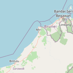
Map view of Miri-Sibuti Coral Reefs National Park

Use this park location map to pinpoint Miri-Sibuti Coral Reefs National Park in Malaysia, understand its exact geographic position, and read its mapped placement within the surrounding landscape more clearly.

Pigeon | © OpenStreetMap contributors

Location context for Miri-Sibuti Coral Reefs National Park

Sarawak
Park atlas

Trace the broader regional protected-area geography, comparing marine and adjacent terrestrial parks.

Explore Nearby National Parks and Protected Areas Surrounding Miri-Sibuti Coral Reefs National Park

Browse a curated selection of national parks and protected areas near Miri-Sibuti Coral Reefs National Park, including other marine protected areas and coastal landscapes in the region. This focused atlas view helps you compare diverse conservation efforts, understand regional park geography, and continue your exploration of Borneo's unique protected landscapes.
National parkSarawak
About 23 km away#1 closest

Southeast

Lambir Hills National Park: Sarawak's National Park Landscape and Geographic Discovery

Explore the mapped terrain and protected boundaries within Sarawak.

Investigate Lambir Hills National Park, a protected national park in Sarawak, Malaysia. This page provides essential geographic context and details its protected landscape identity. Understand its role within the Borneo region's atlas, offering users a deep dive into its mapped terrain and specific regional geography. Discover a key piece of Malaysia's natural protected areas with focused atlas-style information.

Area
69.52 km²
Established
1975
IUCN
II
Relief
Lowland
Watercolor illustration of a landscape with green hills, trees, and a valley
National parkSarawak
About 56 km away#2 closest

South

Niah National Park: Sarawak's Protected National Park Geography and Mapped Landscape

Explore protected area boundaries and regional context within Sarawak

Niah National Park represents a significant protected national park, offering a distinct geographic and landscape identity within Sarawak, Malaysia. This resource facilitates the exploration of its mapped boundaries and its place within the regional atlas of Borneo. Users can delve into the specific geography of this protected area, understanding its landscape characteristics and its contribution to the broader conservation mapping of the region.

Established
1974
Relief
Mountain
Access
Moderate access
Scope
Terrestrial
Nature reserveBrunei
About 73 km away#3 closest

East

Luagan Lalak Forest Recreation Park Nature Reserve: Brunei's Pristine Freshwater Swamp Landscape

Explore mapped protected-area geography and unique wetland terrain.

Luagan Lalak Forest Recreation Park, a protected nature reserve in Brunei, preserves a rare and visually distinctive freshwater swamp ecosystem. Characterized by dark, tranquil waters and vast fields of purun grass, this natural wetland offers a unique landscape context and is a prime location for observing its rich biodiversity, especially its notable birdlife. The park's preservation as an intact swamp environment within a recreational area highlights its ecological importance for regional geography and protected-area mapping.

Area
2.7 km²
Established
1980
IUCN
II
Visitors
4.2K annual
National parkSarawak
About 73 km away#4 closest

Southeast

Loagan Bunut National Park: Protected Landscape in Sarawak, Malaysia

Explore the mapped geography and natural terrain of this national park.

This page offers a detailed atlas-style exploration of Loagan Bunut National Park, situated in Sarawak, Malaysia. Understand the park's designation as a national park and its place within the mapped geography of Borneo. It provides essential context for appreciating the protected landscape and its regional significance.

Area
100 km²
Established
1990
IUCN
II
Scope
Terrestrial
Protected areaBrunei
About 97 km away#5 closest

East

Tasek Merimbun Heritage Park: Protected Landscape Identity and Geographic Atlas

Mapped boundaries and regional natural context for this Brunei protected area.

Tasek Merimbun Heritage Park represents a distinct protected area within the geography of Brunei. This page provides detailed insight into its protected landscape, offering a map-centric view of its boundaries and its placement within the broader natural context of Borneo. Understand the park's geographic significance and explore its unique attributes for structured atlas exploration.

Area
78 km²
Established
1984
Climate
Tropical
Access
Easy access
National parkBintulu Division
About 106 km away#6 closest

Southwest

Bukit Tiban National Park: National Park Protected Area with Mapped Boundaries

Discover its geographic setting within Bintulu Division.

Bukit Tiban National Park stands as a significant protected natural area, offering a deep dive into its specific geography and mapped landscape. As a national park within Bintulu Division, it provides crucial atlas-level insight into regional protected lands. Explore the precise location and understand its context within Malaysia's network of natural conservation areas.

Area
96 km²
Established
2000
IUCN
II
Relief
Upland
National parkMarudi District
About 106 km away#7 closest

East

Gunung Mulu National Park: A Protected National Park with Distinct Geographic Identity in Marudi District

Explore its mapped protected area and regional landscape.

Gunung Mulu National Park stands as a key protected area within Marudi District, Malaysia, offering critical insights into the region's natural geography. This national park entity provides a focal point for understanding mapped protected landscapes and their specific geographic characteristics. Users can explore the park's boundaries and its role within the wider atlas of Malaysian natural areas, gaining a solid foundation in its conservation geography.

Area
528.64 km²
Established
1974
IUCN
II
Relief
Mountain
National parkBintulu Division
About 120 km away#8 closest

Southwest

Similajau National Park: A Protected Landscape within Bintulu Division's Geography

Explore mapped boundaries and regional natural landscape context.

Discover Similajau National Park, a designated national park in Malaysia’s Bintulu Division. This page focuses on the park's identity as a protected landscape, providing essential geographic context for atlas-based exploration. Users can learn about the park’s mapped boundaries and its role within the regional natural geography, offering a clear understanding of its significance as a conservation area.

Area
89.96 km²
Established
1976
IUCN
II
Relief
Upland

Common questions about visiting, size, designation, and location context for Miri-Sibuti Coral Reefs National Park

Miri-Sibuti Coral Reefs National Park FAQs for park facts, access, geography, and protected area context

Find quick answers about Miri-Sibuti Coral Reefs National Park, including protected-area facts, park geography, trail and visitor context, and how the park fits into its surrounding country and regional landscape.
MoriAtlas Explorer

Continue Your Protected Areas Search Across the Global Atlas

Deepen your exploration by continuing the structured search for national parks and protected areas worldwide. Utilize the comprehensive filtering capabilities to compare different conservation landscapes and refine your understanding of global park geography. Discover more about the distribution and characteristics of protected natural areas.

Global natural geography
