

Mori Atlas logo
National parkOl Donyo Sabuk National Park

Discover the mapped boundaries and diverse montane forest ecology of this prominent Kenyan highland.

Ol Donyo Sabuk National Park: Kenya's Iconic Volcanic National Park Landscape

Ol Donyo Sabuk National Park stands as a significant protected landscape within Kenya's central highlands, defined by the imposing Ol Donyo Sabuk mountain. This national park offers a distinct highland wilderness experience, protecting vital montane forest ecosystems that transition into surrounding savanna. As an atlas-focused entry, it showcases the park's mapped geographic boundaries and its role in preserving the unique natural terrain and biodiversity of this region in Kenya.

Mountain forestKenyaCentral highlandsPrimate habitatBirdwatchingVolcanic landscape

Ol Donyo Sabuk National Park

National park

Park overview

Structured park overview, official facts, and landscape profile for Ol Donyo Sabuk National Park

Ol Donyo Sabuk National Park park facts, protected area profile, and essential visitor context

Review the core facts for Ol Donyo Sabuk National Park, including designation, size, terrain, visitor scale, habitats, and operating context in one park-focused overview.

About Ol Donyo Sabuk National Park

Ol Donyo Sabuk National Park protects the mountain of the same name in central Kenya, creating a distinctive protected area that combines forest, woodland, and rocky summit habitats. The mountain rises as an isolated volcanic mass amid the productive agricultural lands of the central highlands, providing a natural sanctuary for wildlife and preserving remnant forest that would otherwise have been lost to farming. The park's location relatively close to major population centers makes it an important green space and recreational resource for the region, while its elevation change from base to summit creates varied ecological zones within a small geographic footprint. Visitors to the park can explore walking trails through the forested slopes, enjoy views from the mountain's higher reaches, and observe wildlife adapted to the diverse habitats found within the reserve.

Quick facts and research context for Ol Donyo Sabuk National Park

Ol Donyo Sabuk National Park is located in Kenya's central highlands region, covering the slopes and summit of Ol Donyo Sabuk mountain. The park protects a transition zone between highland forest and savanna ecosystems. It is known for its population of buffaloes, baboons, and diverse birdlife. The mountain itself rises prominently above the surrounding agricultural landscape, creating a distinctive conservation island within a populated region.

Protection and recognition

Documenting terrestrial boundary scope and official framework records for the regional sanctuary

Ol Donyo Sabuk National Park Protection Status and Conservation Designations

Verified spatial data outlines the terrestrial protection status and formal conservation framework established for Ol Donyo Sabuk National Park. Documented registry records provide essential global context regarding boundary management, national designation criteria, and terrestrial conservation frameworks.

Protection details

Protection scope
Terrestrial
Park context

Deeper park guide and search-rich context for Ol Donyo Sabuk National Park

Ol Donyo Sabuk National Park history, landscape, wildlife, and travel context

Explore Ol Donyo Sabuk National Park through its history, landscape character, ecosystems, wildlife, conservation priorities, cultural context, and seasonal travel timing in a structured park guide built for atlas discovery and search intent.

Why Ol Donyo Sabuk National Park stands out

Ol Donyo Sabuk National Park is best known for its iconic mountain landscape, where forested slopes rise above the surrounding Kenyan highlands. The park is recognized for its primate populations, particularly substantial troops of baboons that inhabit the forest edges and slopes. Birdlife is notably diverse, with numerous forest and savanna species present. The mountain provides panoramic views across the central highlands, making it a destination for visitors seeking a compact but ecologically varied wilderness experience.

Ol Donyo Sabuk National Park history and protected-area timeline

Ol Donyo Sabuk National Park was established to protect the mountain forest and surrounding ecosystems from agricultural expansion and resource extraction pressures in the central highlands. The mountain had long served as a traditional landmark and resource for local communities, and its protection reflects recognition of its ecological and scenic value. The park's creation formalized conservation status for an area that had previously experienced varying levels of human use and pressure. Over time, management has focused on balancing visitor access with habitat preservation, maintaining the forest cover that defines the park's character.

Ol Donyo Sabuk National Park landscape and geographic character

The landscape of Ol Donyo Sabuk is dominated by the mountain itself, a volcanic peak that rises prominently from the surrounding highland plain. The lower slopes feature mixed woodland and grassland, while higher elevations support dense forest cover that transitions to more open rocky terrain near the summit. The mountain's steep contours create varied aspect and microhabitats, with valleys and ridges offering different ecological conditions. Rock outcrops and exposed volcanic formations add visual interest to the landscape, particularly on the more exposed slopes. Views from the higher ground extend across the agricultural landscape of the central highlands, with distant mountains forming the horizon.

Ol Donyo Sabuk National Park ecosystems, habitats, and plant life

The park encompasses a diversity of habitats ranging from savanna grasslands at the base through woodland to montane forest on the upper slopes. This vertical zonation supports a corresponding variety of plant communities, from acacia and grassland communities at lower elevations through increasingly dense woodland to true forest at higher altitudes. The montane forest represents a particularly valuable habitat type in the regional context, as much of the original highland forest has been converted to agriculture. The forest harbors a range of plant species adapted to the cooler, moister conditions found at elevation.

Ol Donyo Sabuk National Park wildlife and species highlights

Wildlife in Ol Donyo Sabuk is adapted to the mixed forest and savanna environments. Baboons are particularly prominent, with troops regularly observed along the forest edges and trails. Buffaloes inhabit the more open areas and forest clearings, while smaller antelopes including dik-diks and impalas are present in appropriate habitats. The diverse bird population includes both forest species and savanna species, with various sunbirds, weavers, and birds of prey recorded. The combination of forest and more open habitats supports a reasonable diversity of species within the park's boundaries.

Ol Donyo Sabuk National Park conservation status and protection priorities

Ol Donyo Sabuk serves as an important conservation island within a densely populated agricultural region, preserving forest habitat that would otherwise likely have been converted to cropland or plantation. The park protects watershed functions on the mountain, helping to maintain water quality and regulate runoff from the higher ground. Its montane forest also stores carbon and provides habitat for species that require forest cover. The protected area represents a component of Kenya's national park system contributing to national biodiversity conservation targets.

Ol Donyo Sabuk National Park cultural meaning and human context

The mountain and surrounding area have traditional significance for local communities in the central highlands, serving as a landmark and source of natural resources. The name Ol Donyo Sabuk reflects local language usage, with the mountain featuring in regional cultural geography. The park exists within a landscape where human settlement and agriculture are intensive, making the protected area an important interface between conservation and community land use.

Top sights and standout views in Ol Donyo Sabuk National Park

The mountain summit offers panoramic views across the Kenyan central highlands, a highlight for visitors. Forest walks provide opportunities to observe baboon troops and experience the montane forest environment. The park's compact size makes it suitable for day visits and shorter excursions. Bird watching is productive, with species diversity reflecting the habitat transition from forest to savanna. The contrast between the forested mountain and surrounding agricultural landscapes demonstrates the conservation value of protecting remnant natural areas.

Best time to visit Ol Donyo Sabuk National Park

The dry seasons from December through March and June through September typically offer more comfortable conditions for walking and wildlife viewing within the park. The wet seasons bring lusher vegetation but can make some trails more difficult and may limit visibility from higher ground. Dry season visits generally coincide with easier access and more predictable wildlife viewing opportunities, though the mountain forest has吸引力 year-round for visitors interested in experiencing this particular habitat type.
Monthly climate preview

Long-term representative monthly temperature and precipitation data for Kenya

Ol Donyo Sabuk National Park Climate Normals and Annual Temperature Rhythm

Representative coordinates document measured long-term monthly temperature and precipitation averages across the protected area. Examining the complete twelve-month climatology profile reveals detailed shifts in regional weather patterns over time.
Annual mean22 °C
20 °C23 °C
Jan22°
Feb23°
Mar23°
Apr23°
May21°
Jun20°
Jul20°
Aug20°
Sep22°
Oct22°
Nov22°
Dec21°
Warmest month
March

23.4 °C

Coolest month
July

19.8 °C

Wettest month
April

4.8 mm/day

Driest month
July

1 mm/day

Park location guide

Geography guide, regional context, and park location map for Ol Donyo Sabuk National Park

Ol Donyo Sabuk National Park park geography, regions, and map view in Kenya

Understand where Ol Donyo Sabuk National Park sits in Kenya through a broader geographic reading of the surrounding landscape, nearby location context, and its mapped position within the national park landscape.

How Ol Donyo Sabuk National Park fits into Kenya

Kenya is a presidential republic in East Africa and the seventh-most populous country on the continent. Its capital is Nairobi, and it borders five countries and the Indian Ocean. The country features significant geographic diversity including Mount Kenya, the Rift Valley, and coastal regions.

Wider geography shaping Ol Donyo Sabuk National Park in Kenya

Kenya is located in East Africa, bordering South Sudan to the northwest, Ethiopia to the north, Somalia to the east, Tanzania to the southwest, and Uganda and Lake Victoria to the west. The southeastern border meets the Indian Ocean. The geography includes the Rift Valley highlands with Mount Kenya, coastal plains, and northern arid regions.

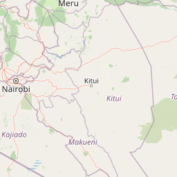
Map view of Ol Donyo Sabuk National Park

Use this park location map to pinpoint Ol Donyo Sabuk National Park in Kenya, understand its exact geographic position, and read its mapped placement within the surrounding landscape more clearly.

Pigeon | © OpenStreetMap contributors
Park atlas

Compare protected areas and national parks across the varied regional geography of Kenya's central highlands.

Discover Surrounding National Parks and Protected Areas Near Ol Donyo Sabuk National Park

After exploring Ol Donyo Sabuk National Park, easily browse other national parks and protected areas situated within Kenya's central highlands and adjacent regions. Compare their distinct mountain forests, volcanic landscapes, and savanna ecosystems to understand the rich, varied conservation geography of this dynamic East African region.
National parkKenya
About 49 km away#1 closest

Southwest

Nairobi National Park: Detailed Geographic Overview and Protected Landscape Atlas

Explore the mapped boundaries and regional context of this Kenyan national park.

Nairobi National Park represents a significant protected national park entity within Kenya. This MoriAtlas entry provides detailed insight into its geographic placement and mapped landscape characteristics. Users can delve into the park's specific location, its protected boundaries, and its contribution to the regional geography of East Africa, facilitating structured map-based exploration and understanding of this vital conservation area.

Area
117 km²
Established
1946
IUCN
II
Relief
Mixed relief
National parkKenya
About 90 km away#2 closest

West

Mount Longonot National Park: Kenya's Mapped Protected Landscape for Atlas Exploration

Discover the natural terrain and park boundaries.

Mount Longonot National Park serves as a vital protected area within Kenya, offering a focused lens for geographical exploration. This national park's defined landscape and mapped boundaries provide essential context for understanding its place in the broader regional geography. Ideal for users seeking detailed information on protected territories, Mount Longonot National Park offers insights into Kenya's natural heritage through an atlas-centric approach.

Scope
Terrestrial
National parkNyeri County
About 92 km away#3 closest

Northwest

Aberdare National Park: Mapped Protected Landscape in Nyeri County

National Park Geography and Atlas Context

Aberdare National Park is a protected national park located within Nyeri County, Kenya. This entry offers detailed geographic information and map context, highlighting its protected boundaries and landscape characteristics. Users can explore its regional setting, understand its specific terrain features, and discover its significance as a conservation area within the Kenyan geography. Access structured data that clarifies the park's identity as a vital protected landscape.

Area
767 km²
Established
1950
IUCN
II
Relief
Mountain
National parkNakuru County
About 106 km away#4 closest

West

Hell's Gate National Park: National Park Atlas and Mapped Landscape Exploration

Discover Nakuru County's protected terrain and geographic context.

Explore the mapped boundaries and unique geographic identity of Hell's Gate National Park, a protected national park within Kenya's Nakuru County. This detailed atlas view focuses on the park's natural landscape and its place within the regional geography, offering structured discovery of its protected terrain and surrounding context. Understand the visual and geographic essence of this significant conservation area.

Area
68.25 km²
Established
1984
IUCN
II
Relief
Mountain
National parkKenya
About 106 km away#5 closest

North

Mount Kenya National Park: Mapped Volcanic Landscape & Protected Area Geography

Kenya's high-altitude Afro-alpine ecosystems and mapped park boundaries.

Mount Kenya National Park safeguards a globally significant volcanic landscape and vital water resources for Kenya. This protected area above 3,000 meters features dramatic peaks, glaciers, and distinctive Afro-alpine flora. Explore its comprehensive mapped boundaries, understand its regional geographic importance, and discover the unique ecosystems that define this exceptional national park through detailed atlas context.

Area
715 km²
Established
1949
IUCN
II
Relief
Mountain
National parkKenya
About 141 km away#6 closest

Northwest

Lake Nakuru National Park: An Atlas of Kenyan Rift Valley Protected Landscapes

Geographic boundaries, terrain analysis, and ecosystem context.

Investigate the physical layout and protected status of Lake Nakuru National Park, a critical habitat located within Kenya's Great Rift Valley. This record details the park's alkaline lake basin, surrounding woodland transitions, and its broader role in regional conservation, providing a clear atlas perspective on one of the country's most significant natural protected areas.

Area
188 km²
Established
1961
Relief
Lowland
Climate
Subtropical
National parkRift Valley
About 152 km away#7 closest

Northwest

Lake Nakuru National Park: Geography and Protected Area Atlas Profile for Rift Valley

Mapped soda lake landscapes and rhino sanctuary boundaries

Lake Nakuru National Park is a prominent protected landscape situated in central Kenya, defined by its shallow alkaline lake and surrounding acacia forests. This profile explores the park's geographic footprint, including its role as a fenced sanctuary for rhinoceros and its location within the volcanic Rift Valley system. The terrain provides a clear study in how tectonic structures and water chemistry shape specialized habitats for large mammals and avian populations.

Area
188 km²
Established
1968
IUCN
II
Relief
Mixed relief
National parkEastern Province
About 168 km away#8 closest

Northeast

Meru National Park National Park: Mapped Protected Boundaries and Eastern Province Geography

Explore regional landscape context and natural terrain.

Meru National Park represents a vital national park entity within the Eastern Province of Kenya, offering unique opportunities for structured geographic and atlas exploration. This page details its protected landscape identity, emphasizing mapped boundaries and the surrounding regional context. Users interested in conservation lands and natural terrain can find comprehensive details on Meru National Park's geographic significance and its role within the broader atlas of protected areas.

Area
870.44 km²
Established
1966
IUCN
II
Relief
Upland

Common questions about visiting, size, designation, and location context for Ol Donyo Sabuk National Park

Ol Donyo Sabuk National Park FAQs for park facts, access, geography, and protected area context

Find quick answers about Ol Donyo Sabuk National Park, including protected-area facts, park geography, trail and visitor context, and how the park fits into its surrounding country and regional landscape.
MoriAtlas Explorer

Continue Your Protected Areas Search Across the Global Atlas

Deepen your exploration by continuing the structured search for national parks and protected areas worldwide. Utilize the comprehensive filtering capabilities to compare different conservation landscapes and refine your understanding of global park geography. Discover more about the distribution and characteristics of protected natural areas.

Global natural geography