

Why Pulu Keeling National Park stands out
Pulu Keeling National Park is renowned for its extraordinary seabird breeding colonies. The island supports what may be the largest red-footed booby colony anywhere on the planet, along with substantial populations of lesser frigatebirds and common noddies exceeding one percent of global populations. The park is also the sole refuge for the Cocos buff-banded rail, an endangered endemic subspecies that survives only on this isolated atoll. The combination of significant breeding populations, endemic species presence, and Ramsar-protected wetland status makes this park a critical conservation site in the eastern Indian Ocean.
Pulu Keeling National Park history and protected-area timeline
The Cocos (Keeling) Islands were first sighted by European explorers in 1609 when Captain William Keeling of the East India Company encountered the archipelago during a voyage from Java. North Keeling was subsequently documented in 1749 through a sketch by Swedish captain Ekeberg, which documented the presence of coconut palms on the island. The island later appeared on charts produced by British hydrographer Alexander Dalrymple in 1789.
In November 1914, during the First World War, the German cruiser SMS Emden was beached on North Keeling Island following a battle with the Australian cruiser HMAS Sydney near Direction Island. The wreck was subsequently damaged by wave action and had largely disappeared by 1919. Historical records indicate that in the 19th century, individuals suffering from beriberi were occasionally left ashore on the island, and several graves from this period and from shipwrecks remain on North Keeling.
The national park was established in December 1995 following an agreement between the Australian National Parks and Wildlife Service and the Cocos Malay community to sustainably manage and restrict hunting activities. Following Cyclone John's devastation of the red-footed booby colony in 1989, legal seabird hunting ceased entirely, allowing populations to recover. The park was designated as a Ramsar Wetland in March 1996.
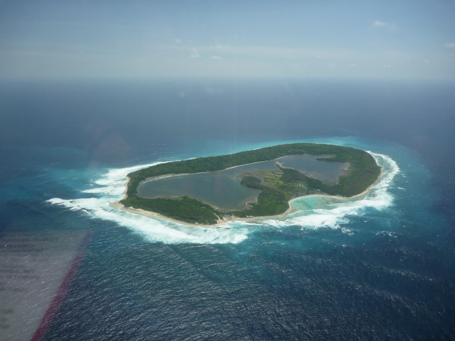
Pulu Keeling National Park landscape and geographic character
North Keeling Island presents a distinctive C-shaped coral atoll morphology representing the northernmost landform of the Cocos (Keeling) archipelago. The island forms a nearly complete ring around a shallow lagoon, with a single narrow opening approximately 50 metres wide on the eastern side providing limited water exchange with the surrounding ocean. The island's total land area spans approximately 1.2 square kilometres while the enclosed lagoon covers roughly 0.5 square kilometres.
The coral substrate forms a low-lying landscape typically ranging only a few metres above sea level, characteristic of Indian Ocean atoll systems. Vegetation consists primarily of coconut palms and coastal scrub, with the interior supporting more dense vegetation in areas protected from salt spray. The surrounding marine environment features typical coral reef communities adapted to the atoll's oligotrophic waters.
Pulu Keeling National Park ecosystems, habitats, and plant life
The ecological significance of Pulu Keeling National Park derives from its role as a critical breeding habitat for colonial seabirds within the eastern Indian Ocean. The island supports breeding populations of red-footed boobies, lesser frigatebirds, and common noddies in numbers that exceed one percent of global populations, qualifying the site as an Important Bird Area. The possibly largest red-footed booby colony in the world is located on this small island, representing an exceptional concentration of this species.
The park's vegetation communities reflect typical atoll ecosystems, with coconut woodland dominating much of the island's surface and native coastal species persisting in more exposed positions. The lagoon supports marine ecosystems adapted to the shallow, warm waters characteristic of coral atoll environments. The surrounding marine zone to 1.5 kilometres from shore is included within the park boundaries, acknowledging the marine foraging requirements of seabird populations.
Pulu Keeling National Park wildlife and species highlights
The avifauna of Pulu Keeling National Park represents the park's most significant wildlife value. The red-footed booby colony on North Keeling is believed to be the largest in the world, with breeding populations that have recovered dramatically since hunting ceased in the late 1980s. Lesser frigatebirds nest in substantial numbers, representing the second largest population within Australian territory. Common noddies complete the trio of globally significant breeding seabirds.
The Cocos buff-banded rail, a subspecies endemic to the Cocos (Keeling) Islands, survives only on North Keeling Island and represents one of the park's most notable conservation priorities. This ground-dwelling bird faces significant vulnerability due to its extremely restricted range. Marine turtles also utilize the island and surrounding waters for nesting and foraging, adding to the park's wildlife significance.
Pulu Keeling National Park conservation status and protection priorities
Pulu Keeling National Park holds dual protection status under both Australian national park legislation and the Ramsar Convention on Wetlands, reflecting its exceptional ecological values. The Ramsar designation, formalized in March 1996, recognizes the island's international importance as a wetland ecosystem supporting significant bird populations. BirdLife International's identification as an Important Bird Area provides additional international recognition of the site's global conservation significance.
The park's conservation framework has evolved through collaborative management between Australian conservation authorities and the Cocos Malay community. Following the 1989 Cyclone John disaster that devastated the red-footed booby colony, permanent cessation of seabird hunting was implemented, allowing populations to recover. The restricted access policy ensures that nesting colonies remain undisturbed during critical breeding periods. The isolation of the Cocos (Keeling) Islands provides a natural buffer against many threats affecting more accessible coastal areas.
Pulu Keeling National Park cultural meaning and human context
The Cocos (Keeling) Islands have a complex history of human interaction beginning with their European discovery in 1609. The islands are named after Captain William Keeling, whose voyage brought the archipelago to European attention. The modern population consists primarily of Cocos Malays, descendants of workers brought to the islands in the 19th century by the Clunies-Ross family who established the settlement on Home Island.
Historical use of North Keeling included periodic visits by Cocos Malays during the interwar period to harvest timber, coconuts, and birds. The graves present on the island reflect its role as a place where individuals suffering from beriberi were left to recover, as well as the aftermath of shipwrecks. The Battle of Cocos in November 1914 added historical significance when the SMS Emden was beached on the island following its engagement with HMAS Sydney. The national park establishment in 1995 reflected a collaborative approach between authorities and the Cocos Malay community regarding sustainable use of the islands' natural resources.
Top sights and standout views in Pulu Keeling National Park
Pulu Keeling National Park protects one of the world's most significant seabird breeding colonies on a remote coral atoll in the eastern Indian Ocean. The island supports what is possibly the largest red-footed booby colony globally alongside substantial populations of lesser frigatebirds and common noddies. The endangered Cocos buff-banded rail survives only within this park, making it essential for the survival of this endemic subspecies. The park's dual Ramsar and national park designation reflects its outstanding universal value as a wetland ecosystem. Access is restricted to preserve the exceptional birdlife that makes this small island one of Australia's most important conservation areas.
Best time to visit Pulu Keeling National Park
The Cocos (Keeling) Islands experience a tropical climate with wet and dry seasons that influence visit conditions. The dry season typically brings more stable weather patterns with lower humidity, which may offer more comfortable conditions for permitted access to the park. However, the park's exceptional wildlife values are present year-round, with breeding cycles for key seabird species occurring throughout the annual calendar.
Visitors should note that access to Pulu Keeling National Park is by permit only, reflecting the need to minimize disturbance to sensitive breeding colonies. The remote location of the Cocos (Keeling) Islands requires careful travel planning regardless of season, and weather considerations should factor into any visit arrangements.