Mori Atlas logo
National parkSahamalaza National Park

Discover the unique protected landscape and endemic species of Sahamalaza National Park

Sahamalaza National Park: Madagascar's Coastal Wetland and Forest National Park

Sahamalaza National Park represents a vital protected landscape in northwestern Madagascar, encompassing approximately 26,035 hectares of diverse terrain including coastal wetlands and transitional forest ecosystems. Designated as both a National Park and a Ramsar Wetland, it serves as a critical sanctuary for endemic wildlife, particularly rare lemur species like the Blue-eyed black lemur. Its geographic position and ecological significance offer a unique lens for exploring Madagascar's rich biodiversity through mapped park boundaries and natural terrain context.

National ParkRamsar WetlandLemur HabitatMadagascarWetland ConservationEndemic Species

Sahamalaza National Park

National park

Park overview

Structured park overview, official facts, and landscape profile for Sahamalaza National Park

Sahamalaza National Park park facts, protected area profile, and essential visitor context

Review the core facts for Sahamalaza National Park, including designation, size, terrain, visitor scale, habitats, and operating context in one park-focused overview.

About Sahamalaza National Park

Sahamalaza National Park represents one of Madagascar's most significant conservation achievements in the twenty-first century, established in 2007 to protect a remarkable concentration of endemic species and critical wetland habitat in the island's northwest. The park occupies a strategic position in the Sofia region, where its landscapes range from coastal marshlands and seasonal lakes to semi-humid forest corridors that provide essential connectivity between Madagascar's distinct biomes. This transitional character gives Sahamalaza exceptional ecological diversity, supporting species adapted to both western dry and eastern humid forest conditions within a relatively compact protected area. The park's management falls under Madagascar National Parks, with substantial financial support from the Madagascar Protected Areas and Biodiversity Fund, reflecting the national and international priority placed on conserving this biodiversity hotspot. Beyond its biological significance, the park contributes to the livelihoods of surrounding communities by supporting sustainable tourism opportunities and ecosystem services including water regulation and soil conservation.

Quick facts and research context for Sahamalaza National Park

Sahamalaza National Park spans 260.35 square kilometers in northwestern Madagascar's Sofia region, near Ambanja and Analalava. The park was established in 2007 and is managed by Madagascar National Parks with funding support from the Madagascar Protected Areas and Biodiversity Fund (FAPBM). In 2017, the park's wetland systems were designated as a Ramsar Wetland of International Importance, recognizing its critical role in supporting migratory waterfowl and maintaining ecological processes. The park encompasses both terrestrial and wetland habitats that serve as refuge for multiple endemic species, particularly several critically endangered lemur species that occur nowhere else on Earth.

Protection and recognition

Analyzing the documented mixed protection scope and regional designation history established in 2017.

Sahamalaza National Park Protection Status and Official Designation History

Exploring the formal protection status of Sahamalaza National Park reveals its structured designation as a mixed protection area established in 2017. Regional planning databases and conservation frameworks record designation milestones to support long term environmental monitoring and geographic mapping.

Protection details

Protection scope
Mixed
Designated year
2017
Transboundary protection
No
Park context

Deeper park guide and search-rich context for Sahamalaza National Park

Sahamalaza National Park history, landscape, wildlife, and travel context

Explore Sahamalaza National Park through its history, landscape character, ecosystems, wildlife, conservation priorities, cultural context, and seasonal travel timing in a structured park guide built for atlas discovery and search intent.

Why Sahamalaza National Park stands out

Sahamalaza National Park is particularly renowned for its population of the Blue-eyed black lemur (Eulemur mac flavifrons), one of the rarest lemurs in Madagascar and a species found almost exclusively within this protected area. The park also protects the Sahamalaza sportive lemur (Lepilemur sahamalazensis) and the Northern giant mouse lemur, both of which have highly restricted distributions. The wetland components of the park provide essential habitat for migratory bird species and serve as a critical buffer zone between Madagascar's western dry forests and the more humid eastern ecosystems, creating a unique ecological transition zone that supports remarkable biodiversity.

Sahamalaza National Park history and protected-area timeline

Sahamalaza National Park was formally established in 2007 as part of Madagascar's expanded network of protected areas aimed at preserving the island's extraordinary endemic biodiversity. The creation of the park responded to growing conservation concerns about the fate of several critically endangered lemur species with extremely limited ranges in the northwest of the island. Prior to national park designation, the area had existed as a lesser-protected zone, but the elevation to full national park status brought increased management resources and international recognition. The subsequent designation of the park's wetland components as a Ramsar Wetland in February 2017 marked a significant milestone, formally acknowledging the site's international importance under the Convention on Wetlands. This dual designation as both a national park and Ramsar site has strengthened protection mechanisms and opened additional funding channels for conservation management.

Sahamalaza National Park landscape and geographic character

The terrain of Sahamalaza National Park encompasses a variety of landscape features that reflect its position along Madagascar's northwestern coast. The protected area includes extensive wetland systems composed of marshes, seasonal lakes, and coastal lagoons that remain flooded during the rainy season and provide critical habitat for waterbirds and aquatic species. These wetland areas are interspersed with patches of semi-evergreen forest and savanna woodland, creating a heterogeneous landscape mosaic. The park's elevation ranges from sea level along the coastal zone to slightly higher terrain inland, with the overall topography characterized by gently rolling terrain rather than dramatic mountainous relief. The proximity to the Mozambique Channel influences the park's climate and vegetation patterns, with seasonal rainfall patterns that support distinct wet and dry seasons affecting the appearance and accessibility of different park zones throughout the year.

Sahamalaza National Park ecosystems, habitats, and plant life

Sahamalaza National Park occupies a biogeographically significant position at the transition between Madagascar's western dry forest ecoregion and the more humid eastern forest belt, creating a unique混合 of ecological communities within a single protected area. The wetland habitats that dominate the park's eastern portions support diverse aquatic vegetation and provide crucial feeding and nesting grounds for migratory bird species traveling along the western Indian Ocean flyway. The forest fragments interspersed throughout the park contain vegetation adapted to varying moisture conditions, from relatively dry woodland species to more humidity-loving trees that represent the edge of eastern forest influence. This ecological diversity creates habitat conditions suitable for a remarkable concentration of endemic species, particularly primates and amphibians that have evolved in isolation on Madagascar.

Sahamalaza National Park wildlife and species highlights

The wildlife of Sahamalaza National Park is distinguished by the presence of several lemur species with extremely restricted distributions, making the park a critical refuge for Madagascar's most endangered primates. The Blue-eyed black lemur represents the park's most celebrated resident, a species characterized by striking golden eyes and predominantly black fur that occurs in very high densities within the protected area. The Sahamalaza sportive lemur, a nocturnal species recognized as one of the smallest living lemurs, inhabits the forest edges and plays an important role in the park's ecosystem through seed dispersal activities. The Northern giant mouse lemur adds further primate diversity, representing one of the larger members of the mouse lemur group. Beyond primates, the park supports populations of endemic amphibians including Boophis ankarafensis, a species described from the park area itself, reflecting the site's herpetological significance.

Sahamalaza National Park conservation status and protection priorities

Sahamalaza National Park plays a vital role in Madagascar's conservation strategy by protecting populations of species that face severe threats from habitat loss and fragmentation outside protected areas. The park's dual designation as a national park and Ramsar Wetland provides layered legal protection for both terrestrial and aquatic ecosystems, addressing the full range of habitats upon which endemic species depend. Conservation priorities within the park focus on maintaining connectivity between forest fragments, protecting wetland hydrological functions, and reducing human-wildlife conflict in zones where agricultural expansion borders protected boundaries. The involvement of the Madagascar Protected Areas and Biodiversity Fund in financing park management demonstrates the integrated approach to conservation financing that Madagascar has developed to ensure long-term protection of its irreplaceable natural heritage.

Sahamalaza National Park cultural meaning and human context

The landscape surrounding Sahamalaza National Park has been inhabited by local communities for generations, with traditional land use practices shaping the rural character of the region. The towns of Ambanja and Analalava serve as gateway communities for visitors accessing the park, and local guides and tourism operators play an important role in providing interpretive services for visitors. The region's economy historically centered on agriculture, particularly rice cultivation and vanilla production, and these activities continue in areas adjacent to the park boundaries. Understanding and integrating traditional land management practices into park management has been an important consideration for maintaining positive relationships between conservation objectives and community livelihoods.

Top sights and standout views in Sahamalaza National Park

Sahamalaza National Park offers exceptional opportunities to observe the critically endangered Blue-eyed black lemur in its natural habitat, with guided walks providing encounters with this distinctive primate that cannot be found anywhere else in the world. The park's wetland areas attract substantial bird populations during migration seasons, creating rewarding wildlife viewing opportunities for ornithologists and nature enthusiasts. The transitional forest environments support a remarkable diversity of endemic species within a relatively compact area, making Sahamalaza an efficient destination for travelers seeking to experience Madagascar's unique biodiversity. The combination of national park and Ramsar Wetland designations provides assurance that both terrestrial and aquatic ecosystems receive formal protection under international conservation frameworks.

Best time to visit Sahamalaza National Park

The optimal time to visit Sahamalaza National Park corresponds with the dry season from April through October, when lower humidity and reduced rainfall make wildlife viewing more comfortable and trail conditions more accessible. During this period, lemur species tend to be more active during daylight hours as they forage in the forest canopy, and the reduced vegetation density improves sighting opportunities. The wet season from November through March brings higher rainfall that can restrict access to certain areas and make some trails more challenging, though the landscape takes on a greener character and wetland areas reach their fullest extent. Visitors interested in bird migration should consider the transition periods at the start and end of the dry season when migratory species are most abundant.
Monthly climate preview

Long-term temperature and precipitation records across twelve months

Sahamalaza National Park Climate Normals and Monthly Weather Data

Sahamalaza National Park records average monthly temperatures from twenty five to thirty degrees Celsius alongside distinct seasonal precipitation shifts. Detailed monthly climate normals reveal comprehensive temperature ranges and rainfall distribution across the representative coordinate.
Annual mean27 °C
25 °C28 °C
Jan28°
Feb28°
Mar28°
Apr28°
May28°
Jun26°
Jul25°
Aug25°
Sep25°
Oct26°
Nov27°
Dec28°
Warmest month
April

28.3 °C

Coolest month
August

25.2 °C

Wettest month
January

12.1 mm/day

Driest month
July

0.3 mm/day

Park location guide

Geography guide, regional context, and park location map for Sahamalaza National Park

Sahamalaza National Park park geography, regions, and map view in Madagascar

Understand where Sahamalaza National Park sits in Madagascar through a broader geographic reading of the surrounding landscape, nearby location context, and its mapped position within the national park landscape.

How Sahamalaza National Park fits into Madagascar

Madagascar is an island nation in the Indian Ocean, positioned off the southeastern coast of Africa. As the world's fourth-largest island and second-largest island country, it stands out for its exceptional biodiversity, over 90% of its wildlife is endemic, making it one of 17 megadiverse countries. The population is approximately 32 million, with Antananarivo as both the capital and largest city.

Wider geography shaping Sahamalaza National Park in Madagascar

Madagascar lies in the Indian Ocean off the southeastern coast of Africa, separated from the mainland by the Mozambique Channel. The island is situated approximately 400 km from the African continent. As the world's fourth-largest island, it also includes numerous smaller peripheral islands.

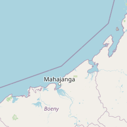
Map view of Sahamalaza National Park

Use this park location map to pinpoint Sahamalaza National Park in Madagascar, understand its exact geographic position, and read its mapped placement within the surrounding landscape more clearly.

Pigeon | © OpenStreetMap contributors

Location context for Sahamalaza National Park

Sofia region
Park atlas

Trace the regional spread of protected landscapes across Madagascar's northwest, comparing their unique conservation profiles.

Explore Nearby National Parks and Protected Areas Beyond Sahamalaza National Park

After exploring Sahamalaza National Park, browse other national parks and protected areas to understand the regional geographic context of Madagascar's diverse conservation efforts. Compare different landscape types, unique endemic species habitats, and the varied protected-area categories found across the island's northwestern and central regions.
Wildlife reserveDiana
About 75 km away#1 closest

East

Manongarivo Special Reserve: Protected Wildlife and River Landscapes in Northern Madagascar

Examining the humid forest terrain and geographic boundaries of the Diana region

Located in the Diana region, Manongarivo Special Reserve serves as a critical protected area within the northern humid rainforest system of Madagascar. The territory is defined by steep forested hills, narrow river valleys, and diverse ecological niches. By analyzing its specific topographic markers and river systems, this entry details the natural landscape and protected status of this significant biodiversity reserve.

Area
327.35 km²
Established
1956
IUCN
IV
Climate
Tropical
National parkMadagascar
About 82 km away#2 closest

Northeast

Nosy Tanikely National Park: Madagascar National Park & Protected Landscape Identity

Mapped geography and regional park context in Madagascar.

Nosy Tanikely National Park is a designated national park in Madagascar, offering a focused entry point for understanding protected land geography. As a key entity within the island's conservation landscape, it provides valuable context for exploring mapped park boundaries and regional geographic features. Discover how this protected area contributes to the broader atlas of Madagascar's natural heritage.

Area
3.41 km²
Established
2011
Relief
Lowland
Climate
Tropical
National parkMadagascar
About 95 km away#3 closest

Northeast

Lokobe National Park: Madagascar's Protected Natural Landscape and Geographic Context

Explore mapped boundaries and regional park geography.

Lokobe National Park is a protected national park situated within Madagascar, an island country recognized globally for its exceptional biodiversity and unique ecosystems. This page offers a detailed, atlas-oriented perspective on Lokobe National Park, focusing on its designation as a protected area, its specific geographic location, and the natural landscape features that define its territory. Users can explore the park's mapped boundaries and understand its contribution to Madagascar's remarkable natural heritage.

Area
15.23 km²
Established
1927
IUCN
II
Climate
Tropical
Nature reserveDiana
About 130 km away#4 closest

East

Réserve naturelle intégrale de Tsaratanana: Highland Massif and Protected Mountain Terrain

High-altitude geography in the Diana region of northern Madagascar

Spanning tens of thousands of hectares, the Réserve naturelle intégrale de Tsaratanana protects the highest mountain terrain in Madagascar. The landscape is defined by the crystalline Vohibory massif, creating a complex topography of deep valleys and dramatic elevation gradients that support endemic primate habitats and montane forest ecosystems.

Area
486.22 km²
Established
1927
IUCN
Ia
Nature reserveDiana Region
About 179 km away#5 closest

Northeast

Ankarana Special Reserve: A Detailed Geographic Atlas of the Diana Region's Limestone Plateau

Mapping the karst landscape, subterranean rivers, and cliff formations.

Examine the rugged topography of Ankarana Special Reserve, featuring a 25-kilometre-long cliff known as the Wall of Ankarana and 100 kilometres of mapped cave passages. This protected area offers deep insight into Madagascar's geological history and rare endemic lemur habitats within its dense, jagged tsingy ridges.

Area
182 km²
Established
1956
IUCN
IV
Relief
Upland
Wildlife reserveSava
About 209 km away#6 closest

Southeast

Réserve spéciale d'Anjanaharibe-Sud: Geography and Protected Area Landscape Overview

Deep forest terrain and mountain ridges in the Sava region

Situated in northeastern Madagascar, Réserve spéciale d'Anjanaharibe-Sud encompasses dense evergreen forests and steep mountain terrain. This protected area serves as a significant conservation landscape for rare endemic species, providing a high-elevation habitat that climbs dramatically from 500 meters to peaks above 2,000 meters across the Sava region.

Area
182.56 km²
Established
1958
IUCN
IV
Relief
Mountain
National parkMadagascar
About 222 km away#7 closest

Northeast

Montagne d'Ambre National Park: Mapped Volcanic Massif and Rainforest Boundaries in Madagascar

Protected montane landscape in the Diana Region of northern Madagascar

Centered around the prominent Mount Ambohitra, this national park showcases a distinct volcanic basaltic massif that creates a dramatic contrast with the nearby semi-desert terrain. Explore the geographic footprint of this biodiversity hotspot, featuring dense montane rainforests, numerous crater lakes, and cascading mountain waterfalls within the northern territory of Madagascar.

National parkDiana Region
About 222 km away#8 closest

Northeast

Montagne d'Ambre National Park: Volcanic Landscapes and Rainforest Geography in Diana Region

Isolated montane ecosystems and volcanic mountain terrain

Montagne d'Ambre National Park forms a distinct volcanic massif in northern Madagascar, sheltering an isolated montane rainforest within the drier Diana Region. The protected area features a network of crater lakes and waterfalls, providing a crucial water catchment for the regional capital. Its unique terrain and dense humid forests act as a natural island for endemic species, creating a sharp contrast with the surrounding semi-arid landscape.

Area
182 km²
Established
1958
IUCN
II
Relief
Mountain

Common questions about visiting, size, designation, and location context for Sahamalaza National Park

Sahamalaza National Park FAQs for park facts, access, geography, and protected area context

Find quick answers about Sahamalaza National Park, including protected-area facts, park geography, trail and visitor context, and how the park fits into its surrounding country and regional landscape.
MoriAtlas Explorer

Continue Your Protected Areas Search Across the Global Atlas

Deepen your exploration by continuing the structured search for national parks and protected areas worldwide. Utilize the comprehensive filtering capabilities to compare different conservation landscapes and refine your understanding of global park geography. Discover more about the distribution and characteristics of protected natural areas.

Global natural geography