Mori Atlas logo
National parkShambe National Park

Discover mapped savanna terrain and riparian ecosystems along the White Nile floodplain.

Shambe National Park: South Sudan's Protected Landscape and Geographic Context

Shambe National Park in South Sudan represents a vital protected area characterized by expansive savanna plains and a distinctive riverine landscape along the White Nile. Established in 1985, this 620 square kilometer park provides crucial habitat for a variety of savanna wildlife, including giraffes, lions, and gazelles. Understanding its geographic setting within Jonglei State offers insight into the natural heritage and conservation efforts in a region marked by extensive wetlands and seasonal flooding.

national parksavannaWhite Nilebig gameriparian ecosystemwetlands

Shambe National Park

National park

Park overview

Structured park overview, official facts, and landscape profile for Shambe National Park

Shambe National Park park facts, protected area profile, and essential visitor context

Review the core facts for Shambe National Park, including designation, size, terrain, visitor scale, habitats, and operating context in one park-focused overview.

About Shambe National Park

Shambe National Park occupies a distinctive position within South Sudan's nascent protected area system, representing an effort to preserve the country's wildlife heritage in the face of decades of conflict and underdevelopment. The park was formally established in 1985 as a national park, receiving International Union for Conservation of Nature Category II designation, which recognizes it as a protected area managed primarily for ecosystem conservation and recreation. The 620-square-kilometer reserve sits on the west bank of the White Nile, placing it within the extensive floodplain systems that define much of Jonglei State's geography. The park's territory extends from the Adior payam in the north through to Kenisa in the Malek payam, reaching toward the vicinity of Ramciel, which holds cultural significance as a potential historical center of regional importance. The landscape consists primarily of savanna grasslands interspersed with woodland patches and the distinctive riverine forests that follow the Nile's course, creating heterogeneous habitat that supports multiple wildlife species. Conservation of large mammals was the primary rationale for the park's establishment, with particular attention given to protecting populations of giraffes, lions, gazelles, monkeys, foxes, and ostriches. These species represent both the park's ecological value and its significance for future tourism potential should stability and infrastructure develop in the region.

Quick facts and research context for Shambe National Park

Shambe National Park is located in Jonglei State, South Sudan, on the western floodplain of the White Nile near the convergence of the Sobat River system. Established in 1985, the park encompasses roughly 620 square kilometers of predominantly savanna and riverine habitat. The protected area extends from Adior payam northward to Kenisa in Malek payam, positioning it in a ecologically significant transitional zone between sudanian and east african biomes. Local communities refer to the area as Anyoop, reflecting the park's deep integration with indigenous toponymy and regional identity.

Protection and recognition

Analyzing documented terrestrial boundaries and conservation frameworks within the regional landscape

Shambe National Park Official Protection Status and Protected Area Designation

Geographic data for Shambe National Park outlines its terrestrial status and documented management boundaries established to safeguard regional wilderness areas. Verifying official conservation designations helps researchers trace the ecological role of the reserve within the wider network of protected zones.

Protection details

Protection scope
Terrestrial
Transboundary protection
No
Park context

Deeper park guide and search-rich context for Shambe National Park

Shambe National Park history, landscape, wildlife, and travel context

Explore Shambe National Park through its history, landscape character, ecosystems, wildlife, conservation priorities, cultural context, and seasonal travel timing in a structured park guide built for atlas discovery and search intent.

Why Shambe National Park stands out

Shambe National Park is best known for its protection of diverse savanna wildlife species along the White Nile floodplain, particularly populations of giraffes, lions, gazelles, and ostriches. The park's location on the Nile's western bank places it within a network of wetlands and seasonal grasslands that support significant populations of large mammals. While not as internationally renowned as other African parks, Shambe represents an important conservation area within South Sudan, protecting species that depend on the riparian and savanna ecosystems of the upper Nile basin.

Shambe National Park history and protected-area timeline

Shambe National Park was established in 1985 during a period when South Sudan was still part of a larger Sudanese state. The creation of the protected area reflected a growing recognition of the need to conserve wildlife populations in the Nile basin region, which had faced increasing pressure from hunting, habitat conversion, and human settlement patterns. The park was designated as a national game park, reflecting its focus on protecting wild animals rather than purely serving recreational purposes. During the decades following its establishment, South Sudan experienced prolonged conflict leading to significant disruption of conservation activities and infrastructure across the country. The park's remote location in Jonglei State, while providing some protection from direct conflict impacts, also meant limited management capacity and investment in protected area infrastructure. Despite these challenges, the legal designation as a national park has persisted, maintaining the framework for conservation even amid periods of instability. The park's establishment also coincided with broader efforts to identify and protect key biodiversity areas within Sudan and later South Sudan following its independence in 2011.

Shambe National Park landscape and geographic character

The landscape of Shambe National Park is defined by its position on the western bank of the White Nile floodplain in Jonglei State. The terrain consists predominantly of flat to gently undulating savanna plains interspersed with seasonal wetlands and patches of woodland vegetation. The Nile's influence creates a distinctive riparian corridor along the park's eastern boundary, where riverine forest species thrive in contrast to the broader savanna matrix. The region experiences pronounced seasonal patterns, with wet seasons bringing extensive flooding that transforms large portions of the landscape into temporary wetlands vital for wildlife and local communities. Grassland areas dominate the higher ground, supporting a mixture of sudanian grass species adapted to the region's climate. The landscape provides important ecological connectivity between the Nile floodplain and the broader savanna ecosystems of eastern South Sudan, making it significant for seasonal wildlife movements and biodiversity maintenance.

Shambe National Park ecosystems, habitats, and plant life

The ecological character of Shambe National Park reflects its position within the sudanian biome of East Africa, characterized by savanna grasslands with scattered trees and woodland patches. The park's location on the Nile floodplain creates a mosaic of habitats ranging from permanently watered riparian zones to seasonally flooded grasslands. This heterogeneity supports diverse plant communities including various grass species, acacia woodlands, and the distinctive riparian vegetation along the Nile corridor. The ecological significance of the area extends beyond its boundaries, serving as part of a larger network of protected and unprotected lands that support wildlife populations across the Nile basin. The park's designation as an IUCN Category II protected area reflects recognition of its ecosystem-level conservation value, even if detailed ecological studies and monitoring remain limited due to the region's challenging operating environment.

Shambe National Park wildlife and species highlights

Shambe National Park protects several notable mammal and bird species, with the park established specifically to provide refuge for populations of foxes, monkeys, lions, gazelles, giraffes, and ostriches. The giraffe population represents a particularly significant conservation asset, as these megaherbivores face pressure across much of their African range. Lions persist in the savanna environments, preying on the various ungulate species including gazelles that inhabit the grasslands. Gazelle populations, including possibly several species adapted to open plains, form important prey bases and contribute to the park's biodiversity value. Ostriches add to the avifauna, representing the large flightless bird component of the park's wildlife community. The riparian areas along the Nile support different species assemblages than the savanna interiors, with monkeys and other arboreal species utilizing the riverine forest habitat. While comprehensive wildlife surveys are not readily available, the species list indicates a functional savanna ecosystem capable of supporting diverse wildlife communities.

Shambe National Park conservation status and protection priorities

Shambe National Park represents an important component of South Sudan's protected area network, providing formal conservation protection for wildlife populations in a region where habitat conversion and hunting pressures remain significant challenges. The park's Category II designation under the IUCN protected area classification system signals its intended function as a national park managed for ecosystem conservation and protection of wild species. Despite the challenging operating environment in South Sudan, the persistence of the protected area designation maintains legal framework for safeguarding the park's natural values. The conservation significance of the area is enhanced by its location within the broader Nile basin, which serves as a crucial corridor for wildlife movements across eastern Africa. Protecting the savanna and riverine ecosystems within Shambe contributes to regional biodiversity conservation goals, particularly for large mammals whose survival depends on large contiguous habitat areas.

Shambe National Park cultural meaning and human context

The area surrounding Shambe National Park is home to pastoralist communities whose traditional livelihoods involve cattle herding and seasonal movements across the landscape. The local name "Anyoop" reflects the indigenous connection to the land and the region's integration with local toponymic traditions. The park's location in Jonglei State places it within territory historically inhabited by various nilotic peoples whose relationship with the land and its wildlife spans generations. The proximity to Ramciel, a location of potential historical and cultural significance in South Sudanese heritage, suggests the broader region holds cultural values beyond its immediate ecological function. Management of the protected area ideally involves consideration of local community needs and traditional land use patterns, though details of current community engagement arrangements are limited in available sources.

Top sights and standout views in Shambe National Park

Shambe National Park offers protection for some of South Sudan's most significant savanna wildlife populations, including giraffes, lions, gazelles, and ostriches within a scenic Nile floodplain setting. The park's location on the White Nile provides a distinctive aquatic component to the landscape, with riverine forests creating a visually contrasting environment to the surrounding savanna plains. The park represents one of the more accessible entry points to South Sudan's protected areas for those interested in experiencing the country's natural heritage, though visitor infrastructure remains limited. Conservation of giraffe populations in particular gives the park regional significance, as these iconic megafauna face mounting pressures across their African range.

Monthly climate preview

Long-term representative monthly temperature and precipitation rhythm in South Sudan

Shambe National Park Climate Normals and Annual Temperature Patterns

Representative coordinates record sustained high temperatures alongside distinct monthly precipitation variations across the year. Reviewing complete monthly climate normals reveals detailed seasonal fluctuations in temperature and rainfall for Shambe National Park.
Annual mean29 °C
26 °C33 °C
Jan30°
Feb31°
Mar33°
Apr31°
May29°
Jun27°
Jul26°
Aug26°
Sep27°
Oct27°
Nov28°
Dec29°
Warmest month
March

32.6 °C

Coolest month
August

25.8 °C

Wettest month
August

5.2 mm/day

Driest month
January

0.1 mm/day

Park location guide

Geography guide, regional context, and park location map for Shambe National Park

Shambe National Park park geography, regions, and map view in South Sudan

Understand where Shambe National Park sits in South Sudan through a broader geographic reading of the surrounding landscape, nearby location context, and its mapped position within the national park landscape.

How Shambe National Park fits into South Sudan

South Sudan is a landlocked sovereign state in East Africa, the most recent country to achieve independence (2011). It occupies an area of 644,329 km² and shares borders with six countries. The Nile River flows through the country, feeding the extensive Sudd wetland. With a population of approximately 12.7 million, South Sudan is linguistically diverse with English as its official language and numerous recognized national languages including Dinka, Nuer, and Bari.

Wider geography shaping Shambe National Park in South Sudan

South Sudan is located in East Africa, landlocked between six countries: Sudan to the north, Ethiopia to the east, Uganda to the south, Kenya to the southeast, the Democratic Republic of the Congo to the southwest, and the Central African Republic to the west. The terrain consists primarily of vast plains and plateaus, with diverse environments ranging from dry savannah to tropical savannah and inland floodplains. The Nile River system runs south to north through the country's center.

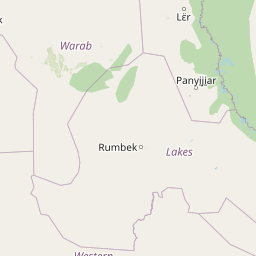
Map view of Shambe National Park

Use this park location map to pinpoint Shambe National Park in South Sudan, understand its exact geographic position, and read its mapped placement within the surrounding landscape more clearly.

Pigeon | © OpenStreetMap contributors
Natural feature types

Explore the Geographic Landscapes and Named Features of Shambe National Park

Continue your geographic study of Shambe National Park by browsing its full collection of mapped natural features. MoriAtlas provides a structured perspective on the riverine ecosystems, savanna plains, and wetlands that characterize this unique region of South Sudan.
Park atlas

Compare protected landscapes and mapped ecosystems surrounding Shambe National Park.

Explore Nearby National Parks and Protected Areas Beyond Shambe National Park

Browse other national parks and protected areas near Shambe National Park, allowing for geographic comparison of similar savanna and White Nile riverine landscapes. Expand your atlas view to trace the regional spread of conservation efforts, revealing how protected ecosystems connect across South Sudan's diverse terrain.
National parkSouth Sudan
110 km away#1 closest

West

Southern National Park National Park: An Extensive Protected Landscape in South Sudan's Nile Basin

Mapped floodplains, savanna woodlands, and large mammal conservation.

Southern National Park stands as a significant protected area within South Sudan, celebrated for its immense scale and rich ecological tapestry. This national park features a complex mosaic of savanna woodlands, extensive seasonal floodplains carved by the Gel and Ibba rivers, and gallery forests lining river corridors. Its designation as a protected landscape highlights its importance for conserving large mammal populations and preserving the unique wetland ecosystems characteristic of the Nile basin's western reaches, offering a prime focus for geographic and atlas exploration.

Area
23,000 km²
Established
1939
IUCN
II
Relief
Lowland
National parkSouth Sudan
About 205 km away#2 closest

Southeast

Bandingilo National Park: South Sudan's Protected National Park Identity

Explore its mapped boundaries and East African landscape.

Bandingilo National Park stands as a distinct protected area within South Sudan, contributing to the nation's catalog of national parks. This entry offers a focused atlas perspective, detailing the park's geographic setting and its mapped features. Understand the landscape context and its relation to the surrounding regional geography of East Africa, providing a foundation for structured discovery of protected lands.

Area
10,000 km²
Established
1992
IUCN
II
Relief
Lowland
National parkDemocratic Republic of the Congo
255 km away#3 closest

Southwest

Garamba National Park: Protected Landscape Atlas and Geographic Context in DRC

Explore Mapped Boundaries of Africa's Historic Savanna Sanctuary

Garamba National Park is a foundational protected area within the Democratic Republic of the Congo, spanning nearly 5,200 square kilometers of distinctive tropical savanna. Established in 1938, this national park is recognized globally as a UNESCO World Heritage Site due to its exceptional biodiversity and role as a critical habitat. The park's landscape is characterized by rolling grasslands, scattered woodlands, and a unique ecological position that supports a rich variety of wildlife, including significant populations of elephants and the DRC's last giraffes. Exploring Garamba National Park through MoriAtlas provides insight into its mapped boundaries, regional geography, and its status as a vital sanctuary for endangered species.

Area
5,200 km²
Established
1938
IUCN
II
Relief
Lowland
National parkSouth Sudan
About 262 km away#4 closest

South

Lantoto National Park: A Protected National Park in South Sudan's Geography

Explore its mapped boundaries and regional landscape context.

Lantoto National Park represents a critical protected area within the vast geography of South Sudan. As a designated national park, it serves as a focal point for understanding landscape features and conservation efforts within East Africa. This atlas-centric view highlights its mapped presence and the broader regional context it occupies, offering a structured approach to exploring South Sudan's natural terrain and protected lands.

Area
760 km²
Established
1986
IUCN
II
Relief
Mountain
National parkSouth Sudan
About 309 km away#5 closest

East

Boma National Park: Protected Landscape in South Sudan's East African Geography

Explore mapped boundaries and regional terrain context.

Boma National Park represents a vital protected landscape within South Sudan. As a national park, it contributes significantly to the geographic understanding of conservation areas in East Africa. Its distinct location and mapped outlines provide essential context for those exploring the regional atlas, highlighting its importance in understanding South Sudan's natural terrain and protected area network.

Area
22,800 km²
Established
1977
IUCN
II
Relief
Lowland
National parkEthiopia
About 333 km away#6 closest

East

Gambela National Park: A Protected National Park within Ethiopia's Geography

Explore mapped landscape features and protected area context.

Gambela National Park represents a vital component of Ethiopia's protected areas network, offering a distinct focus for geographic and atlas exploration. This page provides detailed insights into the park's specific location within Ethiopia, its mapped boundaries, and its significance as a national park. Understand the park's role in the regional landscape and how it contributes to the broader conservation geography of East Africa, providing a valuable resource for structured discovery.

National parkSouth Sudan
About 356 km away#7 closest

South

Nimule National Park: South Sudan's National Park Geography and Protected Boundaries

Explore the terrain and mapped context of this protected landscape.

Nimule National Park represents a key protected area in South Sudan, providing essential geographic data for atlas exploration. This detail page focuses on the park's mapped boundaries, its role as a national park, and its contribution to the regional landscape context of East Africa. Understand the specific terrain and protected land identity that defines this important natural area within the country.

Area
410 km²
Established
1954
IUCN
II
Scope
Terrestrial
Illustrated landscape with winding river, mountains, acacia trees, and green savannah
National parkKaramoja
431 km away#8 closest

Southeast

Kidepo Valley National Park: Remote Protected Savannah Landscape in Karamoja

Explore Uganda's expansive national park mapped geography and wildlife

Kidepo Valley National Park represents a significant protected area within the Karamoja region of Uganda. Its rugged terrain features sweeping savannah plains, distinctive granite kopjes, and seasonal river systems, forming a unique geographic tapestry. This park is crucial for understanding the distribution of protected landscapes in East Africa, offering a distinct atlas perspective on its diverse ecosystems and wildlife concentrations across the mapped terrain.

Area
1,442 km²
Established
1958
IUCN
II
Visitors
2.3K annual

Common questions about visiting, size, designation, and location context for Shambe National Park

Shambe National Park FAQs for park facts, access, geography, and protected area context

Find quick answers about Shambe National Park, including protected-area facts, park geography, trail and visitor context, and how the park fits into its surrounding country and regional landscape.
MoriAtlas Explorer

Continue Your Protected Areas Search Across the Global Atlas

Deepen your exploration by continuing the structured search for national parks and protected areas worldwide. Utilize the comprehensive filtering capabilities to compare different conservation landscapes and refine your understanding of global park geography. Discover more about the distribution and characteristics of protected natural areas.

Global natural geography