
Why Manovo-Gounda St Floris National Park stands out
This park is best known for its remarkable assembly of large African mammals and its status as a UNESCO World Heritage Site under threat. It represents one of the last significant savanna protected areas in Central Africa, supporting populations of black rhinoceros, African elephants, and critically endangered predators including Sudan cheetahs and West African lions. The northern floodplains provide crucial habitat for diverse waterfowl species, earning the park recognition as an Important Bird Area. The park's designation as both a World Heritage Site and a World Heritage in Danger listing highlights its global significance and the urgent conservation challenges it faces.
Manovo-Gounda St Floris National Park history and protected-area timeline
Manovo-Gounda St Floris National Park was established in 1979 as part of the Central African Republic's commitment to preserving its natural heritage. The park was nominated and successfully inscribed on the UNESCO World Heritage List in 1988 during the 12th session of the World Heritage Committee, recognized for meeting natural criteria ix and x that acknowledged its outstanding universal value. Following inscription, the site faced rapidly deteriorating conditions as poaching intensified and armed hunters increasingly targeted wildlife within the park boundaries. By 1997, the World Heritage Committee added the site to the List of World Heritage in Danger, citing severe wildlife depletion, with reports suggesting that poachers may have harvested up to 80 percent of the park's wildlife. The shooting of four park staff members in early 1997 further destabilized management operations. The Central African Republic government subsequently proposed transferring management responsibility to a private foundation, and the World Heritage Committee recommended preparation of a detailed rehabilitation plan.
Manovo-Gounda St Floris National Park landscape and geographic character
The park occupies a diverse terrain of savanna landscapes characterized by rolling grasslands interspersed with woodland patches and riverine forests along the major watercourses. The northern boundaries along the Aouk and Kameur Rivers feature extensive floodplains that seasonally fill with water, creating vital wetland habitat. The Manovo River marks the western boundary approximately 40 kilometers east of N'Délé, while the southern boundary follows the ridge of the Massif des Bongo. The landscape transitions from more dense woodland in the west to increasingly open savanna in the eastern portions. The Vakaga River forms a natural eastern border, and the N'Délé-Birao road transects the park, providing the primary access route through this remote protected area.
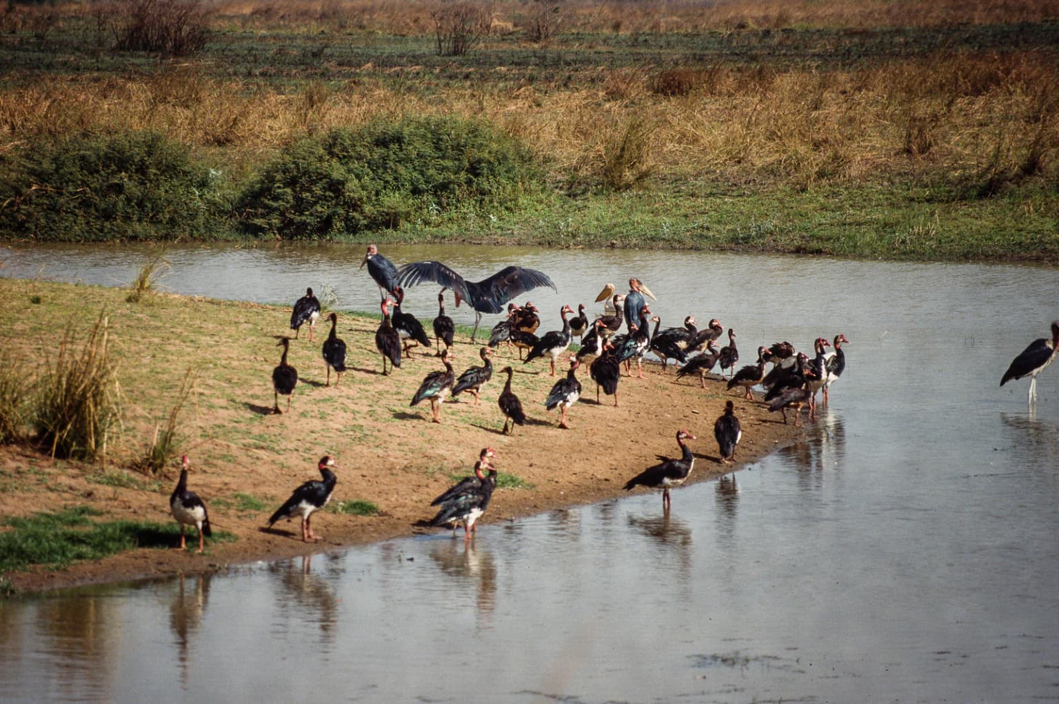
Manovo-Gounda St Floris National Park ecosystems, habitats, and plant life
The park supports a complex mosaic of savanna and woodland ecosystems that harbor remarkable biodiversity. The northern floodplains represent particularly important habitat, supporting diverse waterfowl communities and providing dry-season grazing grounds for large herbivores. The savanna woodlands contain a mixture of grass species and acacia-dominated tree cover, creating ideal conditions for a range of mammal species. The park's position at the interface between Central and West African ecological zones contributes to its species diversity, with the protected area supporting both West African and Central African wildlife assemblages.
Manovo-Gounda St Floris National Park wildlife and species highlights
Manovo-Gounda St Floris National Park historically supported an impressive array of large mammals including black rhinoceros, African elephants, Sudan cheetahs, African leopards, red-fronted gazelles, African buffalos, Kordofan giraffes, and West African lions. The western black rhinoceros, once indigenous to the Central African Republic, was declared extinct in 2011. The park has been designated an Important Bird Area by BirdLife International due to its significance for waterfowl species, particularly on the northern floodplains where numerous waterbird species occur. The combination of savanna and wetland habitats supports both large predators and significant bird populations, though wildlife populations have been severely depleted by decades of poaching pressure.
Manovo-Gounda St Floris National Park conservation status and protection priorities
The park's conservation significance is reflected in its dual status as a UNESCO World Heritage Site and a site on the List of World Heritage in Danger. Inscribed in 1988 under natural criteria ix and x, the park was recognized for its outstanding universal value in representing significant ecological and biological processes. However, the deteriorating security situation, intensive poaching by heavily armed hunters, and illegal grazing have led to catastrophic wildlife declines. The extinction of the western black rhinoceros in 2011 represents a stark reminder of the threats facing the park's fauna. Conservation efforts face profound challenges in the current security environment, though breeding programs and management planning continue in attempts to revive wildlife populations. The park remains a critical priority for international conservation attention given its unique biodiversity value.
Manovo-Gounda St Floris National Park cultural meaning and human context
The park is situated in the remote Bamingui-Bangoran prefecture, a region characterized by low human population density and limited infrastructure. The local communities in the area traditionally practice pastoral activities, and the relationship between human populations and the park's natural resources has historically influenced conservation dynamics. The border region with Chad creates cross-border dimensions to both conservation challenges and traditional land use patterns.
Top sights and standout views in Manovo-Gounda St Floris National Park
Manovo-Gounda St Floris National Park represents one of Central Africa's most significant protected savanna ecosystems and remains on the UNESCO World Heritage List despite its endangered status. The park's 17,400 square kilometer extent contains critical habitat for elephants, giraffes, and diverse antelope species. Its designation as an Important Bird Area recognizes the ecological importance of northern floodplain wetlands. The site exemplifies the tension between exceptional biodiversity value and the severe threats facing Africa's protected areas.
Best time to visit Manovo-Gounda St Floris National Park
The optimal period for visiting Manovo-Gounda St Floris National Park corresponds with the dry season, typically from November through April, when wildlife congregates around remaining water sources and visibility improves in the thinner vegetation. However, the park's current security situation and World Heritage in Danger status mean that visitation is extremely limited and not recommended for general tourism. The post-1997 period has seen all development projects and tourism operations halted due to deteriorating security conditions and the targeting of park personnel.