
Why Thale Ban National Park stands out
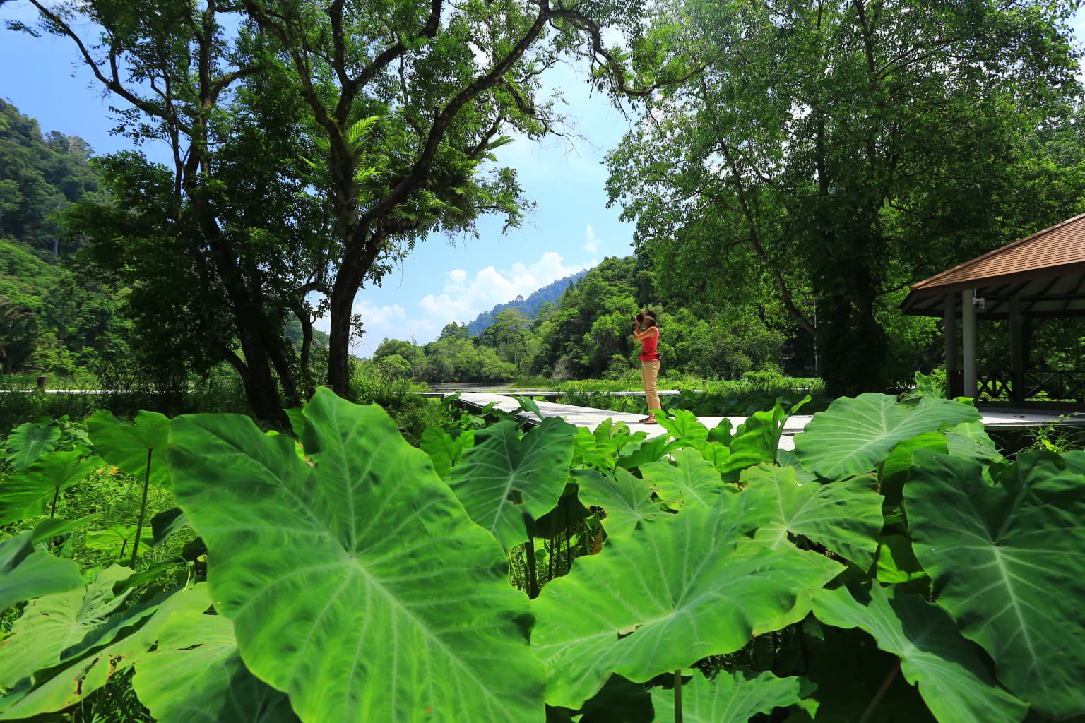
Thale Ban is best known for its unique wetland ecosystem centered on a large natural lake formed by geological processes, as well as its remarkable biodiversity including eight hornbill species and notable mammals such as the endangered Malayan tapir and threatened Sumatran serow. The park features a rare combination of limestone and granite mountain formations, ancient caves, and represents one of the southernmost Thai national parks along the Malaysian border with significant transboundary conservation value.
Thale Ban National Park history and protected-area timeline
Thale Ban National Park was officially established on October 27, 1980, as the 20th national park in Thailand, initially covering approximately 101.68 square kilometres. The area had drawn attention from provincial leadership in the 1970s, with the then-governor of Satun Province, Aris Wongcharoen, recognizing the ecological significance of the forest and wetland area in 1976, subsequently proposing its formal protection to the Forestry Department. Following survey work by forestry officials, the area comprising forest reserves Hua Kha Ming, Kupon, and Puloht in Khuan Don and Mueang Satun districts was declared a national park through royal proclamation published in the Royal Gazette. In 1991, the park was significantly expanded through the incorporation of additional forest areas in the Kuan Si Khit and other forest reserve zones, extending the park's boundary to include the Kuan Bang Khram area and reaching closer to the coast, bringing the total area to approximately 196 square kilometres.
Thale Ban National Park landscape and geographic character
The park's terrain is characterized by a succession of steep limestone and granite mountains rising from the surrounding lowlands, with elevations ranging from near sea level in the wetland areas to 756 metres at Chin Mountain, the park's highest peak. The western mountain ranges feature Ordovician-era limestone formations approximately 500-435 million years old, which have been naturally eroded to form several significant caves including Tham Ton Din, a river cave near the park headquarters, and Tham Lot Puyu. The eastern section around Khuan Don district contains younger Cretaceous granite and granodiorite formations dating to 141-65 million years ago. The central valley contains the park's namesake lake, a freshwater body formed through geological processes that created a natural dam. The park also encompasses one island, Prasumana Island, along its coastal boundary. Several important streams originate in the park including Khlong Klang Ba, Khlong Yaroey, and Khlong Tu Yo, feeding waterfalls such as Namtok Yaroey and Namtok Ton Plio.
Thale Ban National Park ecosystems, habitats, and plant life
Thale Ban supports a remarkable diversity of forest types within a relatively compact area, reflecting its position at the transition between different ecological zones. The tropical rain forest dominates the lower slopes and valley areas, featuring Dipterocarpus, Hopea, Shorea, Parashorea, Alstonia, Caryota, and Calamus species. A particularly notable feature is the presence of mixed deciduous forest in this southern region, which is uncommon in Peninsular Thailand, characterized by Caryota, Lagerstroemia, Pterocymbium, Vitex, Schima, and Dillenia. The coastal forest zone contains mangrove species including Rhizophora mucronata, R. apiculata, Bruguiera cylindrica, and Avicennia. The freshwater swamp and wetland areas around Thale Ban support distinct aquatic vegetation communities including emergent and submerged species adapted to seasonal water level fluctuations.
Thale Ban National Park wildlife and species highlights
The park's wildlife population is notably diverse, with 64 mammal species documented. Among the most significant are the endangered Malayan tapir, the threatened Sumatran serow, and the protected marbled cat. Other predators present include Indochinese tiger, leopard cat, and sun bear. The bird fauna is exceptionally rich with 282 species recorded, including eight hornbill species representing a remarkable proportion of Thailand's hornbill diversity. Notable bird species include chestnut-bellied malkoha, orange-breasted trogon, Gould's frogmouth, blue-winged pitta, blue-crowned hanging parrot, white-crowned hornbill, oriental pied hornbill, and the hill myna. The reptile population includes 40 species with notable mentions for the endangered sunburst turtle, reticulated python, and king cobra. Twenty amphibian species have been recorded, including the distinctive frog Rana glandulosa, known locally as the water dog or klang hao, whose evening calls give rise to the park's name.
Thale Ban National Park conservation status and protection priorities
Thale Ban National Park represents important conservation value as a transboundary protected area linking Thai and Malaysian conservation networks. The park protects significant populations of threatened species including the Malayan tapir, classified as endangered, and the Sumatran serow, classified as threatened, both requiring large contiguous forest habitats. The diverse forest types, from lowland rain forest through montane zones to mangrove wetlands, provide habitat continuity that supports viable populations of wide-ranging species. The park's lake ecosystem and associated wetlands provide critical habitat for amphibians, water birds, and freshwater aquatic species. The presence of the Sakai (Semang) indigenous people within the park adds cultural conservation dimensions to the area's protected status.
Thale Ban National Park cultural meaning and human context
The park contains a small community of Sakai people, also known as Semang or forest people, who represent one of the last remaining indigenous hunter-gatherer groups in southern Thailand. This group of approximately nine individuals maintains traditional knowledge of the forest ecosystem and has historically relied on forest resources for subsistence including hunting with blowguns and gathering forest foods. The park name itself derives from local dialect, with 'Thale Ban' representing a linguistic evolution from the local term 'Ledo Rebban' referring to the large wetland. The area has historical significance as a traditional route connecting Thailand and Malaysia through the mountain valley, and the lake's formation is commemorated in local oral traditions describing the geological events of approximately 300 years ago.
Top sights and standout views in Thale Ban National Park
The park offers several distinctive attractions including the central Thale Ban freshwater lake with its unique formation story and ecological significance, the Tham Ton Din cave system near park headquarters, and the rare deciduous forest ecosystem that is unusual for southern Thailand. The diverse birdlife, particularly the eight hornbill species, makes the park significant for ornithological interest. The combination of limestone and granite mountain landscapes within a single protected area provides geological variety, while the presence of the Sakai indigenous community represents living cultural heritage within the park boundary.
Best time to visit Thale Ban National Park
The park experiences a tropical monsoon climate with distinct wet and dry seasons influenced by both southwest and northeast monsoons. The wet season runs from May through November, with peak rainfall in September averaging 378mm, while the dry season occurs from December to March. Average temperatures remain warm throughout the year at approximately 28°C, with the coolest months seeing lows around 17°C in February and the hottest reaching 39°C in April. The period from November to February generally offers more comfortable conditions for forest exploration, though the landscape remains green and vibrant during the wet season when waterfalls are at their most impressive.