
Why Valle Nuevo National Park stands out
Valle Nuevo is best known for its unique position as a Nearctic ecosystem within the Caribbean, representing a rare high-altitude environment where North American ecological patterns persist in tropical latitudes. The park's extensive Hispaniolan pine forests are among the most significant in the Dominican Republic, while its cloud forest habitats support species found nowhere else on Earth. The dramatic landscape features the fourth-highest peak on Hispaniola, Loma Alto de la Bandera, along with other significant peaks including Loma del Macho and Loma Alto de Valle Nuevo. The park holds special historical significance as the execution site of Francisco Caamaño Deñó, former provisional president of the Dominican Republic, in 1973. The area's glacial heritage, dating to the Last Glacial Maximum, is still visible in the cirques, ridges, and moraines of the highest terrain.
Valle Nuevo National Park history and protected-area timeline
The history of Valle Nuevo reflects a complex trajectory from glacial landscape to protected area. During the Last Glacial Maximum, the Cordillera Central was covered by glacier, and when these ice sheets melted, they left behind the distinctive terrain that characterizes the park today. Spanish chronicler Gonzalo Fernández de Oviedo documented that when Europeans arrived, the area contained shallow lakes, suggesting a landscape quite different from its current configuration. Cattle ranching has been practiced in the region since at least the mid-18th century. The German-born explorer and British consul Robert Hermann Schomburgk visited the area in 1852, followed by Danish explorer and naturalist Henrik Franz Alexander von Eggers in 1887. During the United States military occupation (1916-1924), topographic survey teams explored the area, and one peak, Pico de Sabana Alta, was renamed Alto de la Bandera due to flag-marking operations during triangulation surveys. In 1937, dictator Rafael Leónidas Trujillo constructed a summer residence in the area. The road connecting Constanza and San José de Ocoa was built in the 1950s and inaugurated in 1959, later becoming Route 41. In July 1961, the area was declared a restricted zone. On February 16, 1973, military leader Francisco Caamaño Deñó was executed within the park boundaries at Nizaíto, and a memorial now marks this site. A devastating fire in February 1983 destroyed 32 square kilometers of forest, leading to the area's declaration as a scientific reserve that same year. The park achieved national park status in 1996. A major wildfire in July 2014 destroyed at least one-fourth of the forested area.
Valle Nuevo National Park landscape and geographic character
The landscape of Valle Nuevo National Park is defined by its high-altitude position within the Cordillera Central, creating a mountainous environment unlike any other in the Dominican Republic. The terrain rises from the plateau base at approximately 2,200 meters to the summit of Loma Alto de la Bandera at 2,842 meters, the fourth-highest peak on Hispaniola. Other significant peaks include Loma del Macho, Loma Alto de Valle Nuevo, Tetero de Mejía, Tina (Pajón Blanco), Loma Adentro, and Loma Cabeza del Río. The highest areas display clear evidence of glacial activity, including dramatic cirques, sharp ridges, glacial channels, and characteristic moraines. Depressions in the highest terrain hold peat deposits, remnants of former glacial lakes. The park's position as the southeastern terminus of the Cordillera Central means that the highest foothills to the east rise above 2,000 meters and lie within 30 kilometers of the Caribbean coastline, creating a dramatic transition from tropical lowlands to highland environments. The landscape supports over 500 freshwater springs that feed major river systems, while the Antonio Duvergé Highway traverses the park's length, reaching its highest point at 2,525 meters near the Nizao watershed.
Valle Nuevo National Park ecosystems, habitats, and plant life
The ecological character of Valle Nuevo National Park is defined by its exceptional position within the Nearctic ecozone, a classification that places it among the most distinctive protected areas in the Caribbean. The park's 531 plant species include 138 that are endemic to Hispaniola, reflecting the area's evolutionary significance. Extensive pine forests dominated by the Hispaniolan pine (Pinus occidentalis) cover substantial portions of the park, representing some of the most important pine ecosystems remaining on the island. In the cloud forest areas of Mechecito and Pichón, distinct vegetation communities emerge, including species such as palo de viento, ebony, and cara de hombre (Haenianthus salicifolius). The high elevation and resulting cooler temperatures create conditions that support Nearctic species more commonly found in North American mountainous regions, making this one of the few places in the Caribbean where such ecosystems persist. The climate, with temperatures rarely exceeding 20 degrees Celsius and frequent winter frosts and ice formations, further reinforces the park's ecological distinctiveness.
Valle Nuevo National Park wildlife and species highlights
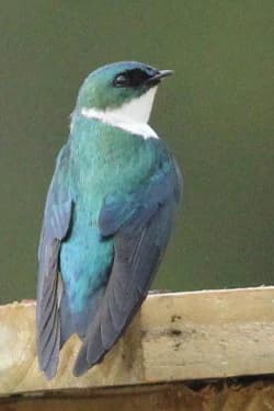
The wildlife community of Valle Nuevo National Park includes 66 bird species, 48 butterfly species, 29 reptile species, and 17 amphibian species, representing a biodiversity significant for an area of its size and elevation. The bird community includes the endemic palmchat (Dulus dominicus), the national bird of the Dominican Republic, along with the Hispaniolan Golden Swallow, which utilizes artificial nest boxes within the park. Among reptiles and amphibians, numerous Anolis lizard species and frog species from the Eleutherodactylus genus persist in the park, which represents one of their last remaining refuges. Feral cats, slightly larger than domestic cats, have been reported throughout the park, while wild rabbits have proliferated notably in the La Nevera and Sabana Quéliz areas. The park's position within the Nearctic ecozone influences which species are present, creating a community composition that differs substantially from lower-elevation Caribbean environments. Approximately 10 percent of the park's area remains under agricultural use, and deforestation has historically impacted portions of the landscape, though significant wildlife populations persist in the more remote higher-elevation areas.
Valle Nuevo National Park conservation status and protection priorities
Valle Nuevo National Park represents a critical conservation priority within the Caribbean due to its unique Nearctic ecosystem and high concentration of endemic species. The park's designation as IUCN Category II reflects its primary function as a national park protecting significant natural landscapes. With 138 plant species endemic to Hispaniola, the area serves as a crucial repository of evolutionary heritage, while the 531 total plant species documented represent substantial biodiversity. The Hispaniolan pine forests constitute some of the most significant remaining examples of this forest type on the island, and the cloud forest habitats of Mechecito and Pichón support species found nowhere else. Conservation challenges include historical deforestation that has altered local microclimates and significantly impacted wildlife, particularly the loss of approximately 75 percent of historical manaclar forests. The devastating fires of 1983 and 2014 caused substantial damage, with the 2014 fire destroying at least one-fourth of the forested area. Ongoing management efforts by the Ministry of Environment and Natural Resources include monitoring stations and the removal of former military installations, though approximately 4,000 residents in agricultural communities within the park continue to influence the landscape.
Valle Nuevo National Park cultural meaning and human context
Valle Nuevo holds significant cultural and historical importance beyond its ecological value. The park contains sites related to the political history of the Dominican Republic, most notably the execution site of Francisco Caamaño Deñó at Nizaíto on February 16, 1973. Caamaño, who had served as provisional president during the 1965 constitutional crisis, took up arms against what he considered the illegitimate government of Joaquín Balaguer. A small iron cross marks the exact location of his execution, and a memorial was added in 2013. The Cyclopean Pyramid (Las Pirámides) in Valle de los Frailes represents another significant cultural landmark, constructed in the late 1950s to commemorate the inauguration of the road connecting Constanza and San José de Ocoa. The monument marks the former municipal boundary between these two towns and stands in a section of road known as La Nevera. Historical figures including Robert Hermann Schomburgk and Henrik Franz Alexander von Eggers documented their travels through the region in the 19th century, contributing to scientific and geographical understanding of this highland area.
Top sights and standout views in Valle Nuevo National Park
The defining highlights of Valle Nuevo include its unique status as a Nearctic ecosystem within the Caribbean, with high-altitude pine forests and cloud forest environments that support exceptional biodiversity. Loma Alto de la Bandera, at 2,842 meters, ranks as the fourth-highest peak on Hispaniola and displays clear glacial geological features including cirques and moraines. The park protects 138 plant species endemic to Hispaniola among its 531 total species. The Antonio Duvergé Highway offers scenic passage through the park, reaching elevations above 2,500 meters and providing access to dramatic viewpoints. The Cyclopean Pyramid monument and the memorial to Francisco Caamaño provide historical and cultural context for visitors. With over 500 freshwater sources feeding major river systems, the park serves as a critical water catchment for the broader region.
Best time to visit Valle Nuevo National Park
The best time to visit Valle Nuevo depends on visitor preferences, though the high-altitude climate creates year-round conditions quite different from typical Caribbean environments. Temperatures rarely exceed 20 degrees Celsius, and winter months frequently bring freezing temperatures, with recorded lows reaching -7 degrees Celsius and an unofficial reading of -10 degrees Celsius in January 2024. The cooler temperatures make the park a refreshing escape from lowland tropical heat, though visitors should prepare for cold conditions, especially at higher elevations. The dry season typically offers more stable weather for hiking and outdoor activities, while the wetter months may bring cloud cover that enhances the atmospheric quality of the cloud forests. Frost and ice formations occur regularly during winter, creating distinctive scenery not expected in Caribbean settings. The park's high elevation means that weather conditions can change rapidly, and visitors should be prepared for variable conditions regardless of when they travel.