

Mori Atlas logo
National parkGan HaShlosha National Park

Discover the unique springs, waterfalls, and ancient ruins within this Israeli national park.

Gan HaShlosha National Park: Protected Landscape and Geographic Context in Israel

Gan HaShlosha National Park offers a distinctive protected landscape situated in Israel's Jordan Valley. This national park is renowned for its warm, spring-fed pools and cascading waterfalls, creating a verdant oasis that contrasts with the surrounding arid terrain. Beyond its natural beauty, the park holds significant archaeological remnants, including Roman and Byzantine structures, detailing centuries of human history. Explore the mapped boundaries and geographic setting of Gan HaShlosha National Park to understand its unique role within the national park atlas.

National ParksNature ReservesSpringsWaterfallsArchaeological SitesJordan Valley

Gan HaShlosha National Park

National park

Park overview

Structured park overview, official facts, and landscape profile for Gan HaShlosha National Park

Gan HaShlosha National Park park facts, protected area profile, and essential visitor context

Review the core facts for Gan HaShlosha National Park, including designation, size, terrain, visitor scale, habitats, and operating context in one park-focused overview.

About Gan HaShlosha National Park

Gan HaShlosha National Park encompasses both natural and archaeological wonders in the heart of the Jordan Valley. The park's defining feature is its series of springs, whose warm waters flow year-round at a consistent temperature, creating a lush riparian environment amid the otherwise dry valley terrain. The water emerges from underground aquifers, carrying minerals that have contributed to the site's historical use as a therapeutic bathing location. The archaeological remains within the park tell the story of a location that has held importance across multiple civilizations and eras. Visitors can explore remains from the Hellenistic period through the Ottoman era, with particularly notable structures from Roman and Byzantine times. The park's combination of natural springs, historical ruins, and relative accessibility has made it a destination for both recreation and education.

Quick facts and research context for Gan HaShlosha National Park

Gan HaShlosha National Park is situated in the Jordan Valley region of northern Israel, approximately 15 kilometers north of the Sea of Galilee. The park features several natural springs that produce warm water year-round, creating a unique aquatic environment in this semi-arid region. The area has been inhabited since antiquity, with archaeological evidence of settlement from the Bronze Age through the Ottoman period. The park's name references the three (shlosha) springs that characterize the site, though some interpretations connect it to a nearby biblical town.

Protection and recognition

Analyzing the terrestrial management scope and official regional protection framework

Gan HaShlosha National Park Protection Status and Territory Designation

Detailed geographic records outline the terrestrial protection status and designated boundaries established for Gan HaShlosha National Park. Exploring official designation parameters helps researchers and geographers compare national conservation boundaries against global protected area frameworks.

Protection details

Protection scope
Terrestrial
Transboundary protection
No
Park context

Deeper park guide and search-rich context for Gan HaShlosha National Park

Gan HaShlosha National Park history, landscape, wildlife, and travel context

Explore Gan HaShlosha National Park through its history, landscape character, ecosystems, wildlife, conservation priorities, cultural context, and seasonal travel timing in a structured park guide built for atlas discovery and search intent.

Why Gan HaShlosha National Park stands out

Gan HaShlosha is best known for its natural spring-fed pools and cascading waterfalls, which create a striking oasis in the Jordan Valley landscape. The warm mineral-rich waters of the springs have attracted visitors for millennia, and today the park offers visitors the opportunity to swim in these ancient waters. Beyond its natural springs, the site is notable for its archaeological significance, with ruins including a Roman-era bathhouse, Byzantine churches, and Crusader-period structures scattered throughout the park.

Gan HaShlosha National Park history and protected-area timeline

The history of Gan HaShlosha stretches back to antiquity. The springs attracted human settlement and use from early periods, with archaeological evidence suggesting continuous occupation or use of the site from at least the Hellenistic era. During the Roman period, the site developed more extensively, with the construction of bathhouses that utilized the therapeutic properties of the mineral-rich spring waters. The Byzantine period saw the establishment of churches at the site, reflecting its continued religious and cultural significance. Later, Crusader forces constructed fortifications at the location before the area came under Mamluk and eventually Ottoman control. The modern national park was established to preserve both the natural springs and the archaeological heritage of this historically significant location.

Gan HaShlosha National Park landscape and geographic character

The landscape of Gan HaShlosha National Park contrasts sharply with the surrounding Jordan Valley environment. While the valley floor is characterized by semi-arid conditions and agricultural development, the springs at Gan HaShlosha create a verdant oasis with lush vegetation, date palms, and papyrus reeds. The terrain slopes gently from the nearby hills down to the spring-fed pools, with small waterfalls cascading over limestone outcrops. The warm waters of the springs maintain temperatures that support aquatic life and allow for year-round swimming, creating a tropical-like environment in this temperate region. The combination of water, vegetation, and the ruins of ancient structures creates a distinctive and memorable landscape.

Gan HaShlosha National Park ecosystems, habitats, and plant life

The ecosystem around Gan HaShlosha's springs represents a unique habitat in the Jordan Valley region. The perpetual flow of warm, mineral-rich water supports a distinctive aquatic environment with species adapted to these conditions. The riparian vegetation surrounding the pools includes species typical of wetland environments, creating a green corridor in the otherwise dry landscape. The area supports birdlife attracted to the water and vegetation, and the stable water temperature creates conditions for aquatic organisms not found in the surrounding ephemeral water bodies. This natural spring system represents an important ecological feature in the region, providing permanent water habitat in an area where such resources are scarce.

Gan HaShlosha National Park conservation status and protection priorities

Gan HaShlosha National Park represents an important conservation priority in Israel, protecting both a unique natural spring ecosystem and significant archaeological heritage. The springs are a limited and irreplaceable resource, and their protection ensures that future generations can experience this natural phenomenon. The park's designation as a national park reflects recognition that both the natural and cultural elements of the site warrant preservation. Management of the park balances public access and recreation with the need to protect the springs, archaeological remains, and the overall ecological character of the area.

Gan HaShlosha National Park cultural meaning and human context

Gan HaShlosha occupies a position in the historical and cultural landscape of Israel that connects natural phenomena with human history across millennia. The location's springs have been a gathering point for communities since ancient times, with the biblical name Shechem potentially connected to this area. The site's continuous use through successive civilizations, from Hellenistic through Ottoman periods, reflects the enduring attraction of the spring waters. Today, the park represents a place where visitors can connect with both natural phenomena and the historical layers of human presence in this region of Israel.

Top sights and standout views in Gan HaShlosha National Park

The natural springs and warm-water pools of Gan HaShlosha remain the park's primary draw, offering visitors the unique experience of swimming in waters that have flowed for millennia. The archaeological trail through ancient ruins provides insight into the site's long history of human use, from Roman bathhouses to Byzantine churches. The contrast between the lush spring environment and the surrounding Jordan Valley creates a striking visual experience. The park's accessibility and the year-round appeal of its warm springs make it a popular destination for families and visitors seeking to experience both nature and history.

Best time to visit Gan HaShlosha National Park

The warm springs of Gan HaShlosha maintain their temperature throughout the year, making the park a viable destination in any season. However, the summer months typically see the highest visitation, when the warm waters provide relief from the Jordan Valley heat. Spring and autumn offer comfortable temperatures for exploring the archaeological site and walking through the park's grounds. Winter brings fewer visitors and can provide a more tranquil experience, though the cooler air temperatures may make swimming less appealing than in summer months.

Monthly climate preview

Long-term representative point measurements of monthly temperature and precipitation values

Gan HaShlosha National Park Climate Normals and Annual Temperature Rhythm

Gan HaShlosha National Park experiences a recorded annual temperature range alongside distinct monthly precipitation variations based on historical climatology data. Examining the complete twelve-month record provides deeper insight into measured baseline conditions across the protected area coordinate.
Annual mean20 °C
11 °C29 °C
Jan11°
Feb11°
Mar14°
Apr18°
May23°
Jun26°
Jul28°
Aug29°
Sep27°
Oct24°
Nov18°
Dec13°
Warmest month
August

28.6 °C

Coolest month
January

10.5 °C

Wettest month
January

3 mm/day

Driest month
July

0 mm/day

Park location guide

Geography guide, regional context, and park location map for Gan HaShlosha National Park

Gan HaShlosha National Park park geography, regions, and map view in Israel

Understand where Gan HaShlosha National Park sits in Israel through a broader geographic reading of the surrounding landscape, nearby location context, and its mapped position within the national park landscape.

How Gan HaShlosha National Park fits into Israel

Israel is a parliamentary republic in the Southern Levant, established in 1948 as a Jewish homeland. It borders Lebanon, Syria, Jordan, and Egypt, with Mediterranean coastline and access to the Red Sea. Jerusalem is the capital, though its status is contested, while Tel Aviv is the largest urban area. The country has a high-income economy with strong technology and innovation sectors.

Wider geography shaping Gan HaShlosha National Park in Israel

Israel occupies the Southern Levant region of West Asia. It is bordered by Lebanon to the north, Syria to the northeast, Jordan to the east, and Egypt to the southwest. The western coast lies on the Mediterranean Sea, while the southern tip reaches the Red Sea. The eastern border includes the Dead Sea, Earth's lowest point. The country occupies the West Bank, Gaza Strip, and Golan Heights.

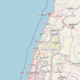
Map view of Gan HaShlosha National Park

Use this park location map to pinpoint Gan HaShlosha National Park in Israel, understand its exact geographic position, and read its mapped placement within the surrounding landscape more clearly.

Pigeon | © OpenStreetMap contributors
Park atlas

Compare diverse protected areas, national parks, and nature reserves throughout Israel's Jordan Valley and contiguous natural landscapes.

Explore Nearby National Parks and Protected Areas Beyond Gan HaShlosha National Park

After delving into Gan HaShlosha National Park, explore additional national parks and nature reserves located within the Jordan Valley and wider Israeli geography. Comparing these protected areas provides valuable geographic context, revealing regional conservation landscapes and facilitating deeper atlas-style discovery of Israel's natural heritage.
National parkIsrael
About 2.5 km away#1 closest

Northwest

Beit Alfa Synagogue National Park: A Protected Landscape in Israel's Geography

Explore the mapped natural terrain and park boundaries.

This page details Beit Alfa Synagogue National Park, a designated national park in Israel, offering an atlas-centric view of its protected landscape. Understand its geographic setting and the mapped context of its protected area within the region. MoriAtlas provides structured data to explore the natural terrain and park boundaries of Beit Alfa Synagogue National Park, enriching your understanding of Israel's conservation lands.

Scope
Terrestrial
Water
No major water
National parkIsrael
About 4.9 km away#2 closest

East

Beit She'an National Park: A Protected Landscape in Israel's National Park Atlas

Mapped geographic context and protected area boundaries.

Beit She'an National Park offers a unique perspective on protected lands within Israel. This detail page provides users with insights into the park's specific geographic setting and its role as a mapped natural landscape. Delve into the structured data surrounding Beit She'an National Park to understand its protected status and its contribution to the broader atlas of conservation areas in the region, offering a grounded view of its terrain and spatial significance.

National parkIsrael
About 26 km away#3 closest

West

Tel Megiddo National Park: Israel's Protected National Park Landscape

Explore the mapped geography and protected area context.

Delve into the specific geographic features and protected landscape identity of Tel Megiddo National Park, a key national park within Israel. This atlas entry focuses on the park's mapped boundaries and its contribution to the regional conservation context, offering a clear view of its terrain and natural setting for dedicated geographic discovery.

National parkIsrael
About 31 km away#4 closest

North

Hamat Tiberias National Park: Explore Protected Landscape and Mapped Geography in Israel

Discover natural terrain and park boundaries within Israel's protected areas.

Delve into Hamat Tiberias National Park, an important protected landscape in Israel. This page offers a detailed look at its geographic setting and the value it holds for atlas exploration. Understand the mapped extent of the park and its place within the regional geography, providing a concrete basis for understanding protected natural areas.

National parkIsrael
About 31 km away#5 closest

Northwest

Zippori National Park: Explore Israel's Protected Landscape and Roman Period History

Mapped geography and protected terrain in the heart of the Levant.

Zippori National Park presents a fascinating protected landscape within Israel, offering insights into its historic terrain and geographic context. As a designated national park, its mapped boundaries delineate an area significant for its archaeological sites, particularly those from the Roman period. This entry provides structured information on the park's protected status and its place within the broader atlas of the Levant, emphasizing discovery through its landscape and historical geography.

IUCN
V
Scope
Terrestrial
Nature reserveAjloun Governorate
About 33 km away#6 closest

Southeast

Ajloun Forest Reserve: A Protected Mediterranean Woodland in Jordan's Ajloun Governorate

Explore the unique protected landscape and mapped terrain of Ajloun Forest Reserve.

Ajloun Forest Reserve is a nature reserve located in Jordan's Ajloun Governorate, distinguished by its rare Mediterranean woodland ecosystem. This protected area provides crucial habitat and showcases a landscape of rolling hills and valleys, offering a stark contrast to the country's predominantly arid regions. Its designation as a UNESCO biosphere reserve underscores its importance for conservation, including efforts in roe deer restoration and the preservation of the black iris, Jordan's national flower. Discover the geographic context and protected nature of this significant Jordanian landscape.

Area
13 km²
Established
1988
IUCN
IV
Relief
Highland
National parkPalestine
About 35 km away#7 closest

Southwest

Shomron National Park: Protected Landscape and Geographic Identity

Explore the terrain and mapped boundaries of this national park.

Shomron National Park preserves the natural landscape and archaeological remnants of the historic Samarian region. This protected area offers a glimpse into the characteristic terrain of the West Bank highlands, featuring rolling hills and rocky outcrops. Understand the geographic placement and protected land context of Shomron National Park within its regional setting.

IUCN
V
Relief
Mountain
Scope
Terrestrial
National parkIsrael
About 37 km away#8 closest

Northwest

Mount Carmel National Park: Explore Israel's Protected Landscape and Geographic Atlas

Discover the mapped boundaries and natural terrain.

Mount Carmel National Park serves as a critical point for understanding protected areas and regional geography within Israel. This national park offers a detailed view of its specific landscape, mapped terrain, and protected boundaries, making it an essential component of any geographic exploration focused on the Levant. Investigate the park's unique features to enhance your understanding of conservation landscapes and their mapping within the Middle East.

Area
100 km²
Established
1960
Relief
Mountain
Climate
Mediterranean

Common questions about visiting, size, designation, and location context for Gan HaShlosha National Park

Gan HaShlosha National Park FAQs for park facts, access, geography, and protected area context

Find quick answers about Gan HaShlosha National Park, including protected-area facts, park geography, trail and visitor context, and how the park fits into its surrounding country and regional landscape.
MoriAtlas Explorer

Continue Your Protected Areas Search Across the Global Atlas

Deepen your exploration by continuing the structured search for national parks and protected areas worldwide. Utilize the comprehensive filtering capabilities to compare different conservation landscapes and refine your understanding of global park geography. Discover more about the distribution and characteristics of protected natural areas.

Global natural geography
