
Why Masoala National Park stands out
Masoala National Park is best known for its exceptional biodiversity and the variety of habitats protected within a single park. The peninsula is home to ten species of lemurs, including the distinctive red ruffed lemur found nowhere else on Earth. The Nosy Mangabe island reserve within the park is one of the best locations in Madagascar for observing the elusive nocturnal aye-aye. The park also protects remarkable reptile diversity, with species including the leaf-tailed gecko, Madagascar day gecko, and various chameleons. The marine component hosts significant coral reef ecosystems and serves as a seasonal destination for humpback whales that migrate to Antongil Bay from July to early September to breed and calve in its warm protected waters.
Masoala National Park history and protected-area timeline
Masoala National Park was established in 1997 as part of Madagascar's expanding network of protected areas during a period of increased recognition of the island's global biodiversity significance. The park's creation represented a commitment to protecting the Masoala Peninsula's unique combination of habitats and species, which had been increasingly threatened by logging and habitat conversion in surrounding areas. In June 2007, Masoala was inscribed as a UNESCO World Heritage Site, becoming part of the Rainforests of the Atsinanana along with five other Madagascar national parks: Marojejy, Zahamena, Ranomafana, Andringitra, and Andohahela. This serial property was recognized for its outstanding universal value in representing the biodiversity and ecological processes of Madagascar's eastern rainforest belt. The park was subsequently placed on the List of World Heritage in Danger in 2010 due to the threat posed by illegal logging, particularly the extraction of rosewood, which continued to impact the site's integrity.
Masoala National Park landscape and geographic character
The Masoala Peninsula extends into the Indian Ocean from northeastern Madagascar, creating a distinctive landform characterized by steep terrain that rises rapidly from the coastline. The park encompasses the peninsula's full spectrum of elevation zones, from sea-level coastal environments to interior rainforest areas. The coastline features rocky shores, sandy beaches, and dense mangrove stands where rivers meet the sea. Inland, the terrain is dominated by steep slopes covered in dense rainforest, with numerous streams cutting through the landscape. The three marine park sections along the coast, Tampolo in the west, Ambodilaitry in the south, and Ifaho in the east, protect the submarine environments adjacent to the peninsula. Antongil Bay, which borders the park to the north, provides sheltered waters that support marine life and serve as a protected breeding ground for migratory whales.
Masoala National Park ecosystems, habitats, and plant life
Masoala National Park protects an extraordinary range of ecological communities that reflect the transition from coastal to interior rainforest environments. The tropical rainforest covering the majority of the park represents some of the least disturbed forest in eastern Madagascar, characterized by tall trees, dense canopy, and high levels of endemism. Coastal forest occurs along the shoreline, while flooded forest occupies low-lying areas where water table levels create permanent or seasonal saturation. Marsh areas and mangrove stands occur where fresh and salt water mix, creating highly productive environments that support specialized species. The marine environments protected within the park's three marine sections feature coral reefs that host diverse invertebrate and fish communities. The tree species Ephippiandra masoalensis is endemic to the park, representing the high degree of local endemism found throughout the Masoala Peninsula.
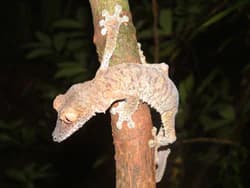
Masoala National Park wildlife and species highlights
Masoala National Park supports exceptional wildlife diversity, with ten lemur species recorded within its boundaries. The red ruffed lemur is particularly associated with the peninsula and represents one of the most distinctive primates found nowhere else. The island reserve of Nosy Mangabe provides habitat for the aye-aye, one of Madagascar's most unusual and elusive lemurs, and the island serves as a stronghold for this unusual species. Reptile diversity is particularly notable, with the leaf-tailed gecko representing one of the island's most extraordinary endemic reptiles, capable of remarkable camouflage against tree bark. The park also protects the Madagascar day gecko, various chameleons, and the tomato frog. Bird species include the striking helmet vanga and the rare red owl, while the Madagascar serpent-eagle was recently rediscovered here and exists in healthy populations only in this part of northeast Madagascar. The day-flying sunset moth, Chrysiridia rhipheus, is another notable species found within the park. Marine wildlife includes diverse fish and invertebrate species on the coral reefs, and from July to early September, hundreds of humpback whales visit Antongil Bay.
Masoala National Park conservation status and protection priorities
Masoala National Park holds global significance as a conservation priority due to its role in protecting Madagascar's eastern rainforest biodiversity. The park's designation as a UNESCO World Heritage Site in 2007 acknowledged its outstanding universal value in representing the island's unique ecosystems and species. However, the site was placed on the World Heritage in Danger list in 2010 due to the severe threat posed by illegal logging, particularly for rosewood, which saw thousands of illegal loggers enter the park during 2009 and 2010. The park's inclusion in the Rainforests of the Atsinanana cluster links it to broader conservation efforts protecting Madagascar's remaining primary rainforest, which represents only a fraction of the island's original forest cover. The marine protected areas within the park contribute to coastal conservation and provide sustainable visitation opportunities through activities like kayaking and snorkeling.
Masoala National Park cultural meaning and human context
The Masoala Peninsula and surrounding region have been inhabited by local communities for generations, with traditional land use patterns shaping the landscape even in areas now included within the park. The towns of Maroantsetra and Antalaha serve as the primary population centers closest to the park, with Maroantsetra being the nearest city to the park entrance. Local communities have historically utilized marine resources along the coast and engaged in subsistence activities within the forest, though the establishment of the protected area has modified access to certain resources. The park's isolation has somewhat limited the scale of human impact compared to other Madagascan protected areas, though ongoing population pressure and economic incentives for resource extraction continue to present challenges.
Top sights and standout views in Masoala National Park
Masoala National Park offers an unparalleled combination of terrestrial and marine biodiversity within a single protected area. The opportunity to observe ten lemur species, including the red ruffed lemur and the elusive aye-aye on Nosy Mangabe, represents a major draw for visitors. The park's reptile diversity, particularly the remarkable leaf-tailed gecko, showcases Madagascar's evolutionary distinctiveness. The marine parks provide excellent opportunities for kayaking and snorkeling among diverse coral reefs, while the seasonal humpback whale presence from July to September offers extraordinary marine mammal viewing. The park's status as Madagascar's largest protected area and its World Heritage designation underscore its conservation importance, while the challenge of protecting it from illegal logging highlights the ongoing threats facing Madagascar's natural heritage.
Best time to visit Masoala National Park
The optimal time to visit Masoala National Park is during the dry season from September to December, when precipitation is lowest and conditions are most favorable for exploration. The park experiences exceptionally high rainfall throughout the year, but this period offers the best combination of weather and accessibility. The cyclone season from January to March should be avoided, as the park's coastal location makes it vulnerable to severe weather during these months. For those interested in humpback whale viewing, visiting from July to early September aligns with the annual migration when hundreds of whales congregate in Antongil Bay to breed and calve. The park is accessible only by boat, typically requiring a three-hour journey from the mainland, and this factor influences visit planning regardless of season.