

Mori Atlas logo
National parkMasoala National Park

Explore the diverse geography, mapped boundaries, and rich ecosystems of this vast national park.

Masoala National Park: Madagascar's Premier Protected Landscape in the Sava Region

(Parc National de Masoala)

Masoala National Park stands as Madagascar's largest protected area, encompassing a significant portion of the Masoala Peninsula in the northeastern Sava Region. This national park protects an extraordinary array of habitats, from dense tropical rainforests and coastal woodlands to flooded forests, marshes, and vital mangrove ecosystems. Its expansive territory also includes three marine parks safeguarding vibrant coral reefs and marine biodiversity, offering a comprehensive look at island ecosystem dynamics.

rainforestmarine protected arealemursWorld Heritage SiteMadagascarisland ecosystem

Masoala National Park

National park

Park overview

Structured park overview, official facts, and landscape profile for Masoala National Park

Masoala National Park park facts, protected area profile, and essential visitor context

Review the core facts for Masoala National Park, including designation, size, terrain, visitor scale, habitats, and operating context in one park-focused overview.

About Masoala National Park

Masoala National Park represents one of Madagascar's most significant conservation achievements, protecting the largest expanse of the island's remaining rainforest and coastal ecosystems. The park's location on the Masoala Peninsula creates a unique situation where terrestrial and marine environments exist in close proximity, allowing for ecological processes that span both domains. The peninsula's exceptional diversity is attributable to its substantial size and the remarkable variety of habitats found within relatively compact geography, from montane rainforest to coastal mangroves. The three marine protected areas within the park, covering approximately 100 square kilometers, include some of Madagascar's most diverse marine environments, supporting complex coral reef communities and numerous fish species. The park's isolation, accessible only by boat, has historically provided some protection against the logging and agricultural expansion that have devastated much of Madagascar's eastern rainforest, though illegal logging for rosewood emerged as a serious threat during 2009 and 2010. The park is governed by the Madagascar National Parks Association and operates as an IUCN Category II protected area, reflecting its primary mandate of preserving natural ecosystems while allowing for sustainable visitation.

Quick facts and research context for Masoala National Park

Masoala National Park covers 2,400 square kilometers in northeastern Madagascar, making it the country's largest protected area. The park was established in 1997 and received World Heritage status in 2007 as part of the Rainforests of the Atsinanana cluster. It encompasses both terrestrial environments including rainforest, coastal forest, flooded forest, marsh, and mangrove, as well as marine environments through three marine park sections: Tampolo, Ambodilaitry, and Ifaho. The park is accessible only by a three-hour boat journey from the mainland, and the region experiences exceptionally high rainfall with the driest period from September to December.

Protection and recognition

Examining the documented preservation boundaries, mixed protection scope, and global designation.

Masoala National Park Protected Area Designation and Global Recognition

Masoala National Park maintains a documented mixed protection status that highlights its integration into the global conservation network. Official records trace its placement within the Rainforests of the Atsinanana UNESCO World Heritage designation to provide clear geographic context on international preservation efforts.

International recognition

Protection details

Protection scope
Mixed
Transboundary protection
No
Park context

Deeper park guide and search-rich context for Masoala National Park

Masoala National Park history, landscape, wildlife, and travel context

Explore Masoala National Park through its history, landscape character, ecosystems, wildlife, conservation priorities, cultural context, and seasonal travel timing in a structured park guide built for atlas discovery and search intent.

Why Masoala National Park stands out

Masoala National Park is best known for its exceptional biodiversity and the variety of habitats protected within a single park. The peninsula is home to ten species of lemurs, including the distinctive red ruffed lemur found nowhere else on Earth. The Nosy Mangabe island reserve within the park is one of the best locations in Madagascar for observing the elusive nocturnal aye-aye. The park also protects remarkable reptile diversity, with species including the leaf-tailed gecko, Madagascar day gecko, and various chameleons. The marine component hosts significant coral reef ecosystems and serves as a seasonal destination for humpback whales that migrate to Antongil Bay from July to early September to breed and calve in its warm protected waters.
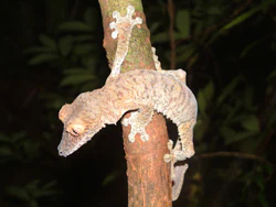
A Leaf-tailed gecko (Uroplatus fimbriatus) perched on a tree trunk with camouflage patterns
Leaf-tailed gecko clinging to a tree branch in Masoala National Park

Masoala National Park history and protected-area timeline

Masoala National Park was established in 1997 as part of Madagascar's expanding network of protected areas during a period of increased recognition of the island's global biodiversity significance. The park's creation represented a commitment to protecting the Masoala Peninsula's unique combination of habitats and species, which had been increasingly threatened by logging and habitat conversion in surrounding areas. In June 2007, Masoala was inscribed as a UNESCO World Heritage Site, becoming part of the Rainforests of the Atsinanana along with five other Madagascar national parks: Marojejy, Zahamena, Ranomafana, Andringitra, and Andohahela. This serial property was recognized for its outstanding universal value in representing the biodiversity and ecological processes of Madagascar's eastern rainforest belt. The park was subsequently placed on the List of World Heritage in Danger in 2010 due to the threat posed by illegal logging, particularly the extraction of rosewood, which continued to impact the site's integrity.

Masoala National Park landscape and geographic character

The Masoala Peninsula extends into the Indian Ocean from northeastern Madagascar, creating a distinctive landform characterized by steep terrain that rises rapidly from the coastline. The park encompasses the peninsula's full spectrum of elevation zones, from sea-level coastal environments to interior rainforest areas. The coastline features rocky shores, sandy beaches, and dense mangrove stands where rivers meet the sea. Inland, the terrain is dominated by steep slopes covered in dense rainforest, with numerous streams cutting through the landscape. The three marine park sections along the coast, Tampolo in the west, Ambodilaitry in the south, and Ifaho in the east, protect the submarine environments adjacent to the peninsula. Antongil Bay, which borders the park to the north, provides sheltered waters that support marine life and serve as a protected breeding ground for migratory whales.

Masoala National Park ecosystems, habitats, and plant life

Masoala National Park protects an extraordinary range of ecological communities that reflect the transition from coastal to interior rainforest environments. The tropical rainforest covering the majority of the park represents some of the least disturbed forest in eastern Madagascar, characterized by tall trees, dense canopy, and high levels of endemism. Coastal forest occurs along the shoreline, while flooded forest occupies low-lying areas where water table levels create permanent or seasonal saturation. Marsh areas and mangrove stands occur where fresh and salt water mix, creating highly productive environments that support specialized species. The marine environments protected within the park's three marine sections feature coral reefs that host diverse invertebrate and fish communities. The tree species Ephippiandra masoalensis is endemic to the park, representing the high degree of local endemism found throughout the Masoala Peninsula.

Masoala National Park wildlife and species highlights

Masoala National Park supports exceptional wildlife diversity, with ten lemur species recorded within its boundaries. The red ruffed lemur is particularly associated with the peninsula and represents one of the most distinctive primates found nowhere else. The island reserve of Nosy Mangabe provides habitat for the aye-aye, one of Madagascar's most unusual and elusive lemurs, and the island serves as a stronghold for this unusual species. Reptile diversity is particularly notable, with the leaf-tailed gecko representing one of the island's most extraordinary endemic reptiles, capable of remarkable camouflage against tree bark. The park also protects the Madagascar day gecko, various chameleons, and the tomato frog. Bird species include the striking helmet vanga and the rare red owl, while the Madagascar serpent-eagle was recently rediscovered here and exists in healthy populations only in this part of northeast Madagascar. The day-flying sunset moth, Chrysiridia rhipheus, is another notable species found within the park. Marine wildlife includes diverse fish and invertebrate species on the coral reefs, and from July to early September, hundreds of humpback whales visit Antongil Bay.

Masoala National Park conservation status and protection priorities

Masoala National Park holds global significance as a conservation priority due to its role in protecting Madagascar's eastern rainforest biodiversity. The park's designation as a UNESCO World Heritage Site in 2007 acknowledged its outstanding universal value in representing the island's unique ecosystems and species. However, the site was placed on the World Heritage in Danger list in 2010 due to the severe threat posed by illegal logging, particularly for rosewood, which saw thousands of illegal loggers enter the park during 2009 and 2010. The park's inclusion in the Rainforests of the Atsinanana cluster links it to broader conservation efforts protecting Madagascar's remaining primary rainforest, which represents only a fraction of the island's original forest cover. The marine protected areas within the park contribute to coastal conservation and provide sustainable visitation opportunities through activities like kayaking and snorkeling.

Masoala National Park cultural meaning and human context

The Masoala Peninsula and surrounding region have been inhabited by local communities for generations, with traditional land use patterns shaping the landscape even in areas now included within the park. The towns of Maroantsetra and Antalaha serve as the primary population centers closest to the park, with Maroantsetra being the nearest city to the park entrance. Local communities have historically utilized marine resources along the coast and engaged in subsistence activities within the forest, though the establishment of the protected area has modified access to certain resources. The park's isolation has somewhat limited the scale of human impact compared to other Madagascan protected areas, though ongoing population pressure and economic incentives for resource extraction continue to present challenges.

Top sights and standout views in Masoala National Park

Masoala National Park offers an unparalleled combination of terrestrial and marine biodiversity within a single protected area. The opportunity to observe ten lemur species, including the red ruffed lemur and the elusive aye-aye on Nosy Mangabe, represents a major draw for visitors. The park's reptile diversity, particularly the remarkable leaf-tailed gecko, showcases Madagascar's evolutionary distinctiveness. The marine parks provide excellent opportunities for kayaking and snorkeling among diverse coral reefs, while the seasonal humpback whale presence from July to September offers extraordinary marine mammal viewing. The park's status as Madagascar's largest protected area and its World Heritage designation underscore its conservation importance, while the challenge of protecting it from illegal logging highlights the ongoing threats facing Madagascar's natural heritage.

Best time to visit Masoala National Park

The optimal time to visit Masoala National Park is during the dry season from September to December, when precipitation is lowest and conditions are most favorable for exploration. The park experiences exceptionally high rainfall throughout the year, but this period offers the best combination of weather and accessibility. The cyclone season from January to March should be avoided, as the park's coastal location makes it vulnerable to severe weather during these months. For those interested in humpback whale viewing, visiting from July to early September aligns with the annual migration when hundreds of whales congregate in Antongil Bay to breed and calve. The park is accessible only by boat, typically requiring a three-hour journey from the mainland, and this factor influences visit planning regardless of season.
Monthly climate preview

Track representative annual temperature swings and monthly precipitation rhythms across the Sava Region

Masoala National Park Climate Normals and Long-Term Weather by Month

Historical monitoring data from representative park coordinates records measured monthly temperature ranges alongside shifting daily precipitation averages throughout the year. Reviewing the complete twelve-month climatology profile allows detailed comparison of seasonal baseline conditions across the protected terrain.
Annual mean22 °C
19 °C24 °C
Jan24°
Feb24°
Mar24°
Apr23°
May22°
Jun20°
Jul19°
Aug19°
Sep20°
Oct21°
Nov23°
Dec24°
Warmest month
February

24.3 °C

Coolest month
August

19.1 °C

Wettest month
March

11.9 mm/day

Driest month
October

2.7 mm/day

Park location guide

Geography guide, regional context, and park location map for Masoala National Park

Masoala National Park park geography, regions, and map view in Madagascar

Understand where Masoala National Park sits in Madagascar through a broader geographic reading of the surrounding landscape, nearby location context, and its mapped position within the national park landscape.

How Masoala National Park fits into Madagascar

Madagascar is an island nation in the Indian Ocean, positioned off the southeastern coast of Africa. As the world's fourth-largest island and second-largest island country, it stands out for its exceptional biodiversity, over 90% of its wildlife is endemic, making it one of 17 megadiverse countries. The population is approximately 32 million, with Antananarivo as both the capital and largest city.

Wider geography shaping Masoala National Park in Madagascar

Madagascar lies in the Indian Ocean off the southeastern coast of Africa, separated from the mainland by the Mozambique Channel. The island is situated approximately 400 km from the African continent. As the world's fourth-largest island, it also includes numerous smaller peripheral islands.

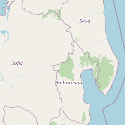
Map view of Masoala National Park

Use this park location map to pinpoint Masoala National Park in Madagascar, understand its exact geographic position, and read its mapped placement within the surrounding landscape more clearly.

Pigeon | © OpenStreetMap contributors

Location context for Masoala National Park

Sava Region
Recorded earthquake history

Explore the Historical Seismic Catalogue for Masoala National Park

Review documented earthquake events and associated epicentre data for the area surrounding Masoala National Park. This MoriAtlas collection offers a clear, objective view of historical seismic activity in the northeastern region of Madagascar for further geographic study.

Masoala National Park Earthquake History

Catalogued events

4 events

Strongest magnitude

Magnitude 4.8

Most recent event

Apr 10, 2022

This history includes earthquakes recorded inside the park or within 50 km of its borders

Visually explore Masoala National Park's diverse rainforests and unique marine protected ecosystems.

Masoala National Park Photography Guide: Explore Rainforest and Marine Protected Area Landscapes

Browse a curated collection of images capturing Masoala National Park's lush rainforests, pristine coastal areas, and vibrant marine protected environments. These visuals offer an essential perspective on the park's terrain, unique habitats, and ecological significance, enhancing your understanding of Madagascar's premier conservation landscape.

A Leaf-tailed gecko (Uroplatus fimbriatus) perched on a tree trunk with camouflage patterns

Rocky shoreline with calm water, dense forest along the coast, and partly cloudy sky

Park atlas

Trace the geographic spread of protected areas and compare unique landscapes across Madagascar.

Explore Related National Parks and Protected Areas Surrounding Masoala National Park

After exploring Masoala National Park, continue browsing other national parks and protected areas across Madagascar's unique geography and diverse ecosystems. Compare distinct conservation landscapes, examine their mapped terrain, and trace the regional spread of protected areas for comprehensive atlas discovery.
National parkAmbatosoa
About 15 km away#1 closest

West

Nosy Mangabe National Park: Atlas Overview of the Ambatosoa Island Forest Reserve

Coastal rainforests and protected lemur habitats in Antongil Bay.

Nosy Mangabe stands as a prominent protected island within the Ambatosoa region of Madagascar. The island is defined by its dense lowland rainforest, dramatic bay topography, and its essential role as a sanctuary for rare primates. This overview maps the park boundary and explores the terrain, historical maritime traces, and the connection between the island and the Masoala peninsula ecosystem.

Area
90.47 km²
Established
1965
IUCN
II
Visitors
3K annual
National parkMadagascar
About 36 km away#2 closest

West

Makira Natural Park: Exploring the Geography and Forested Terrain of Northeastern Madagascar

A vital protected landscape in the humid northeastern forest belt.

Makira Natural Park serves as a benchmark for integrated tropical conservation in Madagascar. Its humid evergreen forests provide a critical habitat for high lemur diversity and specialized botanical associations linked to unique geological substrates. This protected area connects to a larger regional landscape of community-managed forests, acting as a crucial buffer for the biodiversity of the northeastern coastal regions.

Area
3,724.7 km²
Established
2012
IUCN
II
Relief
Mountain
National parkMadagascar
About 43 km away#3 closest

Southwest

Mananara Nord National Park: National Park Geography and Protected Landscape Identity

Explore its mapped boundaries within Madagascar's diverse geography.

Mananara Nord National Park represents a vital protected landscape within Madagascar, offering users a direct entry point for exploring its specific geographic character. As a designated national park, it contributes significantly to the atlas of conservation lands on the island nation. This park provides a focused lens through which to examine regional geography and the mapped extent of protected natural areas, anchoring its identity within the broader context of Madagascar's unique ecological landscape.

Wildlife reserveSava
About 79 km away#4 closest

Northwest

Réserve spéciale d'Anjanaharibe-Sud: Geography and Protected Area Landscape Overview

Deep forest terrain and mountain ridges in the Sava region

Situated in northeastern Madagascar, Réserve spéciale d'Anjanaharibe-Sud encompasses dense evergreen forests and steep mountain terrain. This protected area serves as a significant conservation landscape for rare endemic species, providing a high-elevation habitat that climbs dramatically from 500 meters to peaks above 2,000 meters across the Sava region.

Area
182.56 km²
Established
1958
IUCN
IV
Relief
Mountain
Wildlife reserveAnalanjirofo
About 89 km away#5 closest

Southwest

Réserve spéciale d'Ambatovaky: Protected Forest Landscape and Wildlife Reserve in Analanjirofo

Mapping rugged terrain and endemic forest ecosystems in northeastern Madagascar.

Réserve spéciale d'Ambatovaky spans a challenging, topographically complex area of northeastern Madagascar. This wildlife reserve consists of an unbroken canopy of humid lowland and hill forests, providing a critical refuge for rare raptors and diverse primate communities within the Analanjirofo region's mountainous terrain.

Area
600.5 km²
Established
1958
IUCN
IV
Relief
Upland
Watercolor painting of a mountainous landscape with green vegetation, a body of water, and distant peaks under a light sky
National parkMadagascar
About 90 km away#6 closest

North

Marojejy National Park: A Protected National Park within Madagascar's Unique Geography

Mapped landscape context and regional protected area significance.

Marojejy National Park is a distinct protected area offering rich insights into Madagascar's natural geography. As a national park, its mapped boundaries define a significant landscape that contributes to the island nation's reputation as a biodiversity hotspot. This entry provides essential context for understanding Marojejy National Park's role within the country's protected lands and its value for structured geographic atlas exploration.

Area
555 km²
Established
1998
IUCN
II
Relief
Mountain
Nature reserveDiana
About 182 km away#7 closest

Northwest

Réserve naturelle intégrale de Tsaratanana: Highland Massif and Protected Mountain Terrain

High-altitude geography in the Diana region of northern Madagascar

Spanning tens of thousands of hectares, the Réserve naturelle intégrale de Tsaratanana protects the highest mountain terrain in Madagascar. The landscape is defined by the crystalline Vohibory massif, creating a complex topography of deep valleys and dramatic elevation gradients that support endemic primate habitats and montane forest ecosystems.

Area
486.22 km²
Established
1927
IUCN
Ia
Wildlife reserveSofia region
About 192 km away#8 closest

West

Tampoketsa Analamaitso Reserve: Wildlife Reserve and Protected Forest Geography in Sofia Region

Ecological transition zone featuring humid and dry forest biomes

Tampoketsa Analamaitso Reserve provides a protected sanctuary for northern Madagascar's primate fauna, defined by its rare combination of humid mid-altitude and dense dry forest ecosystems. Managed for habitat conservation, the reserve remains a remote wilderness area with intact forest cover that stretches across the Sofia region. Its geographic importance lies in the ecological gradient that links distinct upland and lowland vegetation types, offering a comprehensive look at the island's diverse natural terrain.

Area
171.5 km²
Established
1958
IUCN
IV
Relief
Upland

Common questions about visiting, size, designation, and location context for Masoala National Park

Masoala National Park FAQs for park facts, access, geography, and protected area context

Find quick answers about Masoala National Park, including protected-area facts, park geography, trail and visitor context, and how the park fits into its surrounding country and regional landscape.
MoriAtlas Explorer

Continue Your Protected Areas Search Across the Global Atlas

Deepen your exploration by continuing the structured search for national parks and protected areas worldwide. Utilize the comprehensive filtering capabilities to compare different conservation landscapes and refine your understanding of global park geography. Discover more about the distribution and characteristics of protected natural areas.

Global natural geography