

Mori Atlas logo
National parkSheikh Jamal Inani National Park

Discover the mapped boundaries and Asian elephant habitat of this key national park.

Sheikh Jamal Inani National Park: Bangladesh's Coastal Forest Protected Landscape

Sheikh Jamal Inani National Park represents a significant protected landscape within Bangladesh, established to conserve its unique coastal forest ecosystem. Covering 7,085 hectares in the Cox's Bazar District, this national park offers a vital sanctuary for Asian elephants and diverse forest-dwelling species. Its designation as a national park in 2019 highlights Bangladesh's commitment to expanding its conservation estate and preserving critical natural habitats.

National ParkBangladeshCoastal ForestAsian ElephantCox's BazarProtected Area

Sheikh Jamal Inani National Park

National park

Park overview

Structured park overview, official facts, and landscape profile for Inani National Park

Inani National Park park facts, protected area profile, and essential visitor context

Review the core facts for Inani National Park, including designation, size, terrain, visitor scale, habitats, and operating context in one park-focused overview.

About Inani National Park

Inani National Park occupies a significant coastal forest area in the southeastern part of Bangladesh, within the administrative boundaries of Cox's Bazar District and Ukhia Upazila. The park's establishment in 2019 reflected Bangladesh's ongoing efforts to expand and consolidate its network of protected areas, particularly in regions with unique ecological characteristics. The Inani reserved forest, which forms the core of the national park, has historically served as a reservoir of biodiversity and a buffer against environmental degradation in this densely populated region of the country. The park's coastal location places it within a broader landscape that includes some of Bangladesh's most famous tourist areas around Cox's Bazar, though the park itself offers a different kind of natural experience focused on forest ecosystems rather than beach recreation. The decision to designate this area as a national park acknowledged both its ecological value and its importance as a habitat for species such as the Asian elephant, which faces significant conservation pressures throughout its range in South and Southeast Asia.

Quick facts and research context for Inani National Park

Inani National Park spans 7,085 hectares along the southeastern coast of Bangladesh in Cox's Bazar District. The park is situated within the Inani reserved forest range of Ukhia Upazila and was established as a national park in July 2019. The protected area is notable for supporting a population of Asian elephants, making it significant for elephant conservation in Bangladesh. The park occupies a coastal forest setting that is relatively unusual among Bangladesh's protected areas, which more commonly consist of mangrove forests, wetlands, and hill forests.

Protection and recognition

Analyzing terrestrial boundaries and official designation history for regional conservation

Official Protection Status and Designation of Sheikh Jamal Inani National Park

Territorial records outline the established conservation status and terrestrial boundary parameters of Sheikh Jamal Inani National Park. Accessing verified historical designation records from 2019 supports a precise understanding of regional resource management and global protected area tracking.

Protection details

Protection scope
Terrestrial
Designated year
2019
Park context

Deeper park guide and search-rich context for Inani National Park

Inani National Park history, landscape, wildlife, and travel context

Explore Inani National Park through its history, landscape character, ecosystems, wildlife, conservation priorities, cultural context, and seasonal travel timing in a structured park guide built for atlas discovery and search intent.

Why Inani National Park stands out

Inani National Park is best known for its Asian elephant population, which represents one of the key wildlife conservation values of the park. The coastal forest ecosystem that spans much of the protected area distinguishes it from other national parks in Bangladesh, most of which feature mangrove, wetland, or hill forest environments. The park's location within the Inani reserved forest range provides a continuous stretch of forested habitat that supports not only elephants but also numerous other species that rely on this coastal forest habitat. The relatively recent establishment as a national park (2019) also marks it as one of the newer protected areas in Bangladesh's conservation estate.
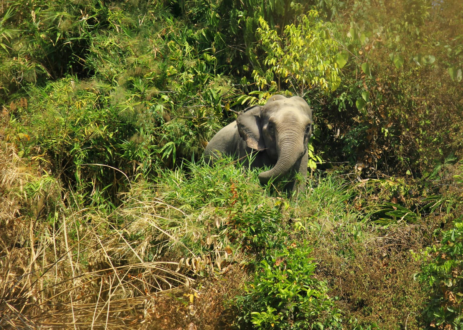
Asian elephant partially hidden by green vegetation and tall grasses
Asian elephant partially visible in dense vegetation at Sheikh Jamal Inani National Park

Inani National Park history and protected-area timeline

Inani National Park was officially declared as a national park by the Government of Bangladesh on 9 July 2019, marking its formal inclusion in the country's national park system. Prior to this designation, the area existed as the Inani reserved forest, a protected forest area managed under Bangladesh's forest conservation framework. The park was originally named after Sheikh Jamal, the second son of Sheikh Mujibur Rahman, who was Bangladesh's first president and founding leader. Following significant political changes in Bangladesh in 2024, specifically the fall of the Hasina regime, the park's name was modified to remove the reference to Sheikh Jamal. This renaming reflected a broader reassessment of how public spaces and protected areas in Bangladesh were named and commemorated. The transition from reserved forest status to national park designation represented an elevation in the level of protection and recognition afforded to this coastal forest area, bringing with it enhanced conservation mandates and management frameworks.

Inani National Park landscape and geographic character

The landscape of Inani National Park is characterized by coastal forest vegetation that covers rolling terrain within the southeastern coastal region of Bangladesh. The park lies within the Inani reserved forest range, which features a mix of forest types adapted to the coastal environment. The terrain in this part of Cox's Bazar District is relatively undulating compared to much of Bangladesh's generally flat deltaic landscape, though the elevations remain modest. The forest canopy within the park provides a distinct green landscape that contrasts with the more commonly associated agricultural and wetland scenery of rural Bangladesh. The park's location near the Bay of Bengal influences its environmental character, bringing coastal climatic conditions including higher humidity and the effects of monsoonal rainfall patterns that shape the vegetation and overall landscape appearance.

Inani National Park ecosystems, habitats, and plant life

The natural environment of Inani National Park is defined by its coastal forest ecosystem, which represents a distinct habitat type within Bangladesh's ecological framework. The forest supports a range of plant species adapted to the coastal conditions, including the moisture-loving vegetation typical of this region of South Asia. Beyond the forest's botanical value, the area serves as important habitat for numerous wildlife species, with the Asian elephant being the most prominent conservation priority. The coastal forest environment provides elephants and other wildlife with food sources, shelter, and movement corridors that are essential for their survival. The park's ecosystem services extend beyond wildlife habitat to include watershed protection, carbon storage, and soil conservation functions that benefit the broader landscape.

Inani National Park wildlife and species highlights

Inani National Park is home to a population of Asian elephants, the flagship species of the protected area and the primary focus of conservation attention. Asian elephants are endangered throughout their range, and populations in Bangladesh face particular pressures from habitat loss, human-wildlife conflict, and fragmentation of their habitats. The park's forest environment provides crucial habitat for these elephants, offering both feeding grounds and movement corridors. Beyond elephants, the coastal forest supports a variety of other wildlife species, though detailed species inventories specific to the park are limited in the available source material. The broader Cox's Bazar region is known for its biodiversity, and the Inani reserved forest has historically served as a refuge for wildlife in this populated coastal area.

Inani National Park conservation status and protection priorities

The designation of Inani National Park in 2019 represented a significant conservation achievement for Bangladesh, formalizing protection for an important coastal forest area and its resident wildlife. The elevation of the Inani reserved forest to national park status brought additional regulatory protections and management attention to the area. For Asian elephant conservation specifically, the park provides critical habitat in a country where elephant populations are scattered and face significant threats. The protected area status helps buffer against habitat degradation and fragmentation that could otherwise threaten the elephant population and other forest-dependent species. Bangladesh's national park system forms a cornerstone of the country's approach to biodiversity conservation, and Inani National Park contributes to the representativeness of this network by including a coastal forest habitat that is less common among the country's other protected areas.

Inani National Park cultural meaning and human context

The area now known as Inani National Park has historical roots in the Inani reserved forest, which has been a feature of the Cox's Bazar region for many decades. The region around Ukhia Upazila is home to communities that have lived in proximity to these forest areas, with traditional relationships to the land and its resources. The original naming of the park after Sheikh Jamal reflected Bangladesh's tradition of commemorating founding leaders and their families through place names, a common practice in the country. The subsequent renaming of the park in 2024 following the fall of the Hasina regime illustrates how political history continues to shape the naming and identity of places throughout Bangladesh.

Top sights and standout views in Inani National Park

Inani National Park stands out within Bangladesh's protected area network for several reasons. Its coastal forest environment is relatively uncommon among the country's national parks, most of which feature other habitat types. The presence of a viable Asian elephant population gives the park significant conservation importance, as these endangered animals occupy only fragmented habitats across Bangladesh. The park's establishment in 2019 makes it one of the newer national parks in the country, representing Bangladesh's continued investment in expanding its conservation estate. The Inani reserved forest history provides a foundation of forest protection that the national park designation has built upon.

Best time to visit Inani National Park

The optimal time to visit Inani National Park aligns with Bangladesh's cool, dry winter season from November through February, when temperatures are more comfortable for outdoor exploration and rainfall is minimal. The monsoon season from June through September brings heavy rainfall to the Cox's Bazar region, which can limit accessibility and make forest visits more difficult. The pre-monsoon spring months (March through May) feature warming temperatures and increasing humidity before the rains arrive. Visitors interested in wildlife viewing should note that elephants and other wildlife may be more active during cooler parts of the day, particularly in early morning and late afternoon.


Monthly climate preview

Long-term representative temperature and monthly precipitation averages for Bangladesh

Sheikh Jamal Inani National Park Climate Normals and Weather by Month

Historical climate data for Sheikh Jamal Inani National Park documents a measured annual rhythm of monthly temperature ranges and precipitation rates from representative coordinate records. Reviewing the complete twelve-month profile provides detailed long-term averages for analyzing regional environmental patterns across the protected area.
Annual mean27 °C
22 °C29 °C
Jan22°
Feb24°
Mar26°
Apr28°
May29°
Jun29°
Jul28°
Aug28°
Sep28°
Oct28°
Nov26°
Dec24°
Warmest month
May

28.8 °C

Coolest month
January

22.3 °C

Wettest month
July

34.5 mm/day

Driest month
January

0.2 mm/day

Park location guide

Geography guide, regional context, and park location map for Inani National Park

Inani National Park park geography, regions, and map view in Bangladesh

Understand where Inani National Park sits in Bangladesh through a broader geographic reading of the surrounding landscape, nearby location context, and its mapped position within the national park landscape.

How Inani National Park fits into Bangladesh

Bangladesh, officially the People's Republic of Bangladesh, is a South Asian country known for its high population density and deltaic geography formed by the Ganges-Brahmaputra river system. It gained independence from Pakistan in 1971 following a liberation war. The country operates as a unitary parliamentary republic with Dhaka as its capital and largest city, while Chittagong serves as the second-largest city and main port.

Wider geography shaping Inani National Park in Bangladesh

Bangladesh occupies the delta region at the confluence of the Ganges, Brahmaputra, and Meghna rivers in South Asia. The country shares land borders with India to the north, west, and east, and Myanmar to the southeast, while its southern boundary is along the Bay of Bengal. The terrain is predominantly low-lying deltaic plain, making it susceptible to flooding. The country is separated from Bhutan and Nepal by the Siliguri Corridor and from China by the Indian state of Sikkim.

Map view of Inani National Park

Use this park location map to pinpoint Inani National Park in Bangladesh, understand its exact geographic position, and read its mapped placement within the surrounding landscape more clearly.

Pigeon | © OpenStreetMap contributors

Explore the unique visual identity of this Bangladesh protected area, tracing its diverse terrain and distinct coastal forest scenery.

Sheikh Jamal Inani National Park Photos: Visualizing Coastal Forest Landscapes and Elephant Habitats

Browse a curated collection of imagery to visually explore the unique coastal forest ecosystem and rolling terrain characterizing Sheikh Jamal Inani National Park. These photographs offer essential insights into the protected area's environment, highlighting the natural habitats that sustain its notable Asian elephant population.

Asian elephant partially hidden by green vegetation and tall grasses

Park atlas

Compare diverse protected landscapes and their unique geography within southeastern Bangladesh.

Continue Your Park Discovery: Explore National Parks and Protected Areas Near Sheikh Jamal Inani National Park

After exploring Sheikh Jamal Inani National Park, trace other national parks and protected areas within Bangladesh's southeastern coastal region, including adjacent forest ecosystems. Compare their distinctive coastal forest habitats, mapped terrain, and regional conservation contexts to deepen your understanding of the area's protected landscapes.
National parkBangladesh
About 24 km away#1 closest

North

Himchari National Park: A Protected National Park within Bangladesh's Delta Geography

Mapped protected area and landscape context in South Asia.

Himchari National Park represents a vital protected natural area contributing to the rich geography of Bangladesh. As a national park, it offers users a focal point for understanding mapped landscapes and the distribution of conservation lands within the South Asian delta region. Exploring this entity provides insight into the country's protected areas and their unique environmental settings for structured atlas discovery.

Area
17.29 km²
Established
1980
IUCN
IV
Relief
Upland
National parkCox's Bazar District
About 61 km away#2 closest

North

Medhakachhapia National Park: Protected Mangrove Landscape and Geography in Cox's Bazar

Mapping the boundaries of a unique coastal Bangladesh National Park.

Medhakachhapia National Park is a distinct protected area in Cox's Bazar District, Bangladesh, renowned for its old-growth Rhizophora apiculata mangrove forest. Spanning approximately 396 hectares, it serves as a crucial habitat and represents a specific type of tropical coastal landscape. This park's designation as a national park highlights its conservation importance, particularly its role in protecting some of Bangladesh's most mature mangrove stands. Explore its geographic context and protected status for a deeper understanding of its natural landscape.

Area
3.959 km²
Established
2008
IUCN
IV
Relief
Lowland
National parkRangamati District
About 151 km away#3 closest

North

Kaptai National Park: Protected Landscape and Geographic Context in Rangamati District

Explore its mixed evergreen forest and lakeside terrain.

Kaptai National Park is a crucial protected area located in Bangladesh's Rangamati District, renowned for its mixed evergreen forests and unique position adjacent to Kaptai Lake. This detail page provides an atlas-oriented perspective on the park's geographic identity, mapped boundaries, and its role within the diverse Chittagong Hill Tracts region. Understand the terrain, from rolling hills to lakeside environments, and appreciate its conservation significance as a national park.

Area
54.64 km²
Established
1999
IUCN
II
Climate
Subtropical
National parkBangladesh
About 154 km away#4 closest

Northwest

Nijhum Dweep National Park: A Protected Landscape in Bangladesh's Geographic Atlas

Explore the mapped boundaries and regional setting of this national park.

Nijhum Dweep National Park is a key protected area situated within the deltaic geography of Bangladesh. This detailed entry provides insight into its mapped landscape, natural terrain, and its significance as a national park. Understand its geographic context and explore its protected boundaries as part of a broader atlas of natural areas, offering a factual basis for understanding this unique South Asian landscape.

Area
163.52 km²
Established
2001
IUCN
IV
Relief
Lowland
National parkChittagong District
About 173 km away#5 closest

North

Baroiyadhala National Park: A Vital Wildlife Corridor and Protected Forest Landscape in Bangladesh

Discover its terrain, mapped boundaries, and regional significance.

Baroiyadhala National Park, situated in Bangladesh's Chittagong District, stands as a critical national park dedicated to preserving forest ecosystems and functioning as an essential wildlife corridor. The park's undulating terrain and dense vegetation are vital for supporting threatened species and maintaining habitat connectivity. This page offers an atlas-style exploration of Baroiyadhala National Park, detailing its protected area status, geographic context within the Chittagong region, and its significance for conservation in South Asia, providing a rich understanding of its natural landscape.

Area
29.34 km²
Established
2010
IUCN
II
Climate
Tropical
National parkChin State
About 179 km away#6 closest

East

Natmataung National Park: Protected Mountain Landscape and Biodiversity Atlas in Chin State

Explore the mapped terrain and elevational gradients of Mount Victoria.

Natmataung National Park, located in Chin State, Myanmar, offers a profound encounter with dramatic mountainous terrain and exceptional biodiversity. As a protected national park, it safeguards Mount Victoria, the highest peak in the region, and a remarkable ecological gradient spanning diverse forest types. This page provides an atlas-focused view of its geography, highlighting the steep ridgelines, deep valleys, and unique habitats that define this significant protected landscape and its role in watershed protection.

Area
723 km²
Established
2010
IUCN
II
Relief
Mountain
National parkIndia
About 196 km away#7 closest

Northeast

Phawngpui National Park: An Indian National Park's Protected Landscape and Geography

Explore its mapped boundaries and regional natural terrain.

Phawngpui National Park stands as a distinct protected area within India, contributing significantly to the nation's atlas of natural landscapes. Its designation as a national park underscores its importance for understanding regional geography and mapped terrain. This profile focuses on the park's specific protected-area identity and its role in the broader geographic context of India, offering clear insights for landscape and park map discovery.

Area
50 km²
Established
1992
IUCN
II
Visitors
469 annual
National parkPatuakhali District
About 221 km away#8 closest

West

Kuakata National Park: Protected Landscape Identity and Geographic Atlas

Mapped boundaries and regional context within Patuakhali District.

Kuakata National Park is a significant protected area designated as a national park, offering valuable insights into the geography of Patuakhali District. This park detail page provides a structured exploration of its mapped boundaries and protected landscape characteristics, serving as a vital entry point for understanding its place within the larger atlas of global natural sites. Focus on its specific geographic setting and conservation status for detailed discovery.

Area
16.13 km²
Established
2010
IUCN
II
Relief
Lowland

Common questions about visiting, size, designation, and location context for Inani National Park

Inani National Park FAQs for park facts, access, geography, and protected area context

Find quick answers about Inani National Park, including protected-area facts, park geography, trail and visitor context, and how the park fits into its surrounding country and regional landscape.
MoriAtlas Explorer

Continue Your Protected Areas Search Across the Global Atlas

Deepen your exploration by continuing the structured search for national parks and protected areas worldwide. Utilize the comprehensive filtering capabilities to compare different conservation landscapes and refine your understanding of global park geography. Discover more about the distribution and characteristics of protected natural areas.

Global natural geography