Mori Atlas logo
National parkSimbalbara National Park

Discover the mapped boundaries and unique geography of this national park.

Simbalbara National Park: Protected Landscape in India's Himalayan Foothills

Simbalbara National Park represents a significant protected natural area within the Sirmour District of India's Himachal Pradesh. Situated in the Kiyarda Dun valley, this national park covers approximately 27.88 square kilometers, showcasing a distinctive landscape characterized by dense sal forests and open grassy glades. Its location in the foothills of the Himalayas provides a unique geographic setting, bridging tropical and sub-tropical ecosystems. This page serves as an atlas entry, detailing the park's protected landscape identity and its regional geographic context for exploration.

National ParkSal ForestTiger HabitatHimalayan FoothillsWildlife ConservationSirmour District

Simbalbara National Park

National park

Park overview

Structured park overview, official facts, and landscape profile for Simbalbara National Park

Simbalbara National Park park facts, protected area profile, and essential visitor context

Review the core facts for Simbalbara National Park, including designation, size, terrain, visitor scale, habitats, and operating context in one park-focused overview.

About Simbalbara National Park

Simbalbara National Park represents an important conservation unit within Himachal Pradesh's protected area network, located in the foothills of the Himalayas in northern India. The park occupies the Kiyarda Dun valley, a distinctive geological formation that provides a transition between the lower Himalayan ranges and the plains of northern India. The protected area was formally established in its current national park status in 2010, though it had been managed as a wildlife sanctuary since 1958 under the name Simbalbara Wildlife Sanctuary. The expansion in 2010 added approximately 8.88 square kilometers to the original sanctuary area, creating the current park boundaries. The Himachal Pradesh Travel and Tourism Department maintains the park in its natural state, preserving the forest ecosystem and the valley's ecological integrity. The Simbalbara Forest Rest House offers visitor access to the area, with connections from Puruwala providing views across the valley landscape. The park's position along the border between Himachal Pradesh and Haryana gives it strategic importance as a trans-Himalayan conservation corridor.

Quick facts and research context for Simbalbara National Park

Simbalbara National Park lies in the Kiyarda Dun valley of Sirmour District in Himachal Pradesh, India, positioned along the state's border with Haryana. The protected area was elevated from wildlife sanctuary status to national park designation in 2010, expanding from its original 19.03 square kilometers to encompass roughly 27.88 square kilometers. The park features dense sal forest as its primary vegetation type, interspersed with grassy meadows and a year-round stream that sustains the valley ecosystem. The park is also referred to as Col. Sher Jung National Park, reflecting its historical designation.

Protection and recognition

Verifying documented terrestrial conservation status and global protection framework listings.

Simbalbara National Park Protection Status and Terrestrial Conservation Designations

Simbalbara National Park features documented terrestrial protection status as part of the broader regional conservation network. Compiling official designation records and administrative frameworks provides clear geographic context regarding the management boundaries governing terrestrial wildlife sanctuaries.

Protection details

Protection scope
Terrestrial
Park context

Deeper park guide and search-rich context for Simbalbara National Park

Simbalbara National Park history, landscape, wildlife, and travel context

Explore Simbalbara National Park through its history, landscape character, ecosystems, wildlife, conservation priorities, cultural context, and seasonal travel timing in a structured park guide built for atlas discovery and search intent.

Why Simbalbara National Park stands out

Simbalbara National Park is best known for its extensive sal forest coverage and its role as a habitat for tigers and other large mammals in the Himalayan foothills. The park protects a representative sample of the sal-dominated forest ecosystems found in the lower Himalayan region, with the dense tree canopy and grassy glades creating ideal conditions for wildlife. The presence of species such as goral, sambar deer, chital, and tigers distinguishes this protected area within Himachal Pradesh's network of national parks. Additionally, the park supports significant birdlife including several species of hornbills, raptors, and water-associated birds around the perennial stream.

Simbalbara National Park history and protected-area timeline

The Simbalbara area was first designated for formal protection in 1958, when it was established as the Simbalbara Wildlife Sanctuary covering an initial area of 19.03 square kilometers. This early protected area status recognized the ecological significance of the Kiyarda Dun valley and its sal forest ecosystem. The sanctuary remained under wildlife protection management for over five decades, preserving the forest habitat and the wildlife populations within it. In 2010, the protected area underwent a significant upgrade in status when an additional 8.88 square kilometers were incorporated and the area was redesignated as Simbalbara National Park, bringing the total protected area to approximately 27.88 square kilometers. This elevation from sanctuary to national park status reflects the increased conservation priority given to the area and provides stronger legal protections for the forest and wildlife within its boundaries. The park is also known as Colonel Sher Jung National Park, a name that appears in some official and regional references.

Simbalbara National Park landscape and geographic character

The landscape of Simbalbara National Park is defined by the Kiyarda Dun valley, a valley formation in the lower Himalayan foothills of Sirmour District. The terrain features a mix of dense forest-covered slopes and open grassy areas known as glades, creating a varied topography within the park boundaries. The valley floor contains a perennial stream that provides year-round water availability, supporting the forest ecosystem and the wildlife dependent on it. The surrounding terrain rises into forested hills that form the valley's edges, with the overall setting characterized by the transition between Himalayan mountain terrain and the more gently undulating landscapes of the northern Indian plains. The forest cover is predominantly sal, a tropical hardwood species that forms dense canopy in the lower elevations, while the grassy glades provide open spaces within the forest matrix.

Simbalbara National Park ecosystems, habitats, and plant life

The ecological character of Simbalbara National Park is shaped by its sal forest-dominated vegetation, which represents a significant forest type in the Himalayan foothills. The principal canopy species include sal (Shorea robusta) and Terminalia elliptica, forming the upper canopy layer across much of the park. Along the riverine areas, additional tree species including eucalyptus, jamun (Syzygium cumini), and Senna siamea occur, creating more diverse habitat zones near the watercourse. The combination of dense forest and open grassy clearings creates a mosaic of habitats that supports various wildlife species. The presence of a perennial stream adds a wetland component to the ecosystem, providing water sources and supporting riparian vegetation that adds to the overall biodiversity of the protected area.

Simbalbara National Park wildlife and species highlights

Simbalbara National Park supports a range of mammalian species characteristic of Himalayan foothills forests. Large mammals found in the park include tigers, goral, sambar deer, and chital (spotted deer), representing the park's most notable megafauna. Other mammalian herbivores present include nilgai, wild boar, porcupines, barking deer (muntjac), and rhesus macaques. The avian fauna includes several notable species, with three hornbill species recorded within the park, along with Indian rollers, dollarbirds, and various kingfisher species. Raptors present in the area include crested serpent eagles, Brahminy kites, and long-billed vultures, providing bird-of-prey diversity. The mixture of forest, grassland, and water habitats supports this wildlife community throughout the year.

Simbalbara National Park conservation status and protection priorities

Simbalbara National Park functions as a protected area within India's national park system, designated under IUCN Category II for national park protection. The park contributes to conservation of the sal forest ecosystem, which has faced pressure from logging and agricultural expansion across its historical range in the Himalayan foothills. By protecting a representative area of this forest type, the park helps maintain habitat for species including tigers, which are flagship predators for conservation in India. The elevation from wildlife sanctuary to national park status in 2010 reflects the conservation significance of the area and provides enhanced protection mechanisms for the ecosystem. The park also contributes to Himachal Pradesh's protected area network, which aims to preserve the state's ecological diversity across different altitude zones and forest types.

Simbalbara National Park cultural meaning and human context

The park is located in Sirmour District, a region within Himachal Pradesh that has historical connections to various hill kingdoms and ruling families of the Himalayan area. The alternate name of Colonel Sher Jung National Park suggests a historical association with military or colonial-era figures in the region, though detailed cultural history of the park area is limited in the available sources. The nearest village to the park is Palhori, located opposite the Simbalbara area, representing the local communities who have historical connections to the landscape. The region around the park has been inhabited for generations, with the forest areas traditionally used for timber, grazing, and other livelihood activities before formal protection was established.

Top sights and standout views in Simbalbara National Park

The dense sal forests of Simbalbara National Park represent one of the park's most distinctive features, covering the valley slopes and creating a substantial canopy. The tiger population in the park makes it significant within India's wildlife conservation framework, as tigers remain a priority species for protection across the country's protected areas. The presence of three hornbill species distinguishes the birdlife of this park, as hornbills are notable birds associated with forest habitats. The grassy glades within the forest create open viewing areas where wildlife can be observed, particularly during the winter months when animals frequent the more open areas. The park's location in the Himalayan foothills provides scenic landscape value, with the valley setting offering views of surrounding forested hills.

Best time to visit Simbalbara National Park

October and November are identified as the optimal months for visiting Simbalbara National Park, during which the weather conditions and wildlife activity patterns provide favorable conditions for exploration. These autumn months follow the monsoon season, when the landscape is lush from rainfall but the vegetation begins to thin slightly, improving wildlife visibility. The cooler temperatures of late autumn make comfortable for walking trails through the forest and adjoining areas. The post-monsoon period also brings animals to the water sources along the perennial stream as other water sources dry up, increasing wildlife viewing opportunities. Visitors planning trips during this period should note that the park's accessibility may vary with seasonal road conditions in the Himalayan region.
Monthly climate preview

Long-term representative temperature and precipitation averages for Simbalbara National Park

Simbalbara National Park Climate Normals and Monthly Weather Patterns

Simbalbara National Park exhibits a measured annual rhythm of recorded monthly temperatures and precipitation rates derived from multi-year climatology data. Examining the complete twelve-month profile provides deeper analytical context regarding historical climate variation across the protected terrain.
Annual mean22 °C
12 °C31 °C
Jan12°
Feb14°
Mar19°
Apr25°
May30°
Jun31°
Jul28°
Aug26°
Sep24°
Oct21°
Nov17°
Dec13°
Warmest month
June

30.6 °C

Coolest month
January

11.7 °C

Wettest month
August

12.1 mm/day

Driest month
November

0.2 mm/day

Park location guide

Geography guide, regional context, and park location map for Simbalbara National Park

Simbalbara National Park park geography, regions, and map view in India

Understand where Simbalbara National Park sits in India through a broader geographic reading of the surrounding landscape, nearby location context, and its mapped position within the national park landscape.

How Simbalbara National Park fits into India

India is a South Asian country bordered by the Indian Ocean, Arabian Sea, and Bay of Bengal. It shares land borders with Pakistan, China, Nepal, Bhutan, Bangladesh, and Myanmar. The country has a population of over 1.4 billion people and operates as a federal parliamentary republic with its capital in New Delhi.

Wider geography shaping Simbalbara National Park in India

India occupies the Indian subcontinent in South Asia, bordered by the Arabian Sea to the southwest, the Bay of Bengal to the southeast, and the Indian Ocean to the south. It shares land borders with Pakistan to the west, China, Nepal, and Bhutan to the north, and Bangladesh and Myanmar to the east. The territory also includes the Andaman and Nicobar Islands in the Indian Ocean.

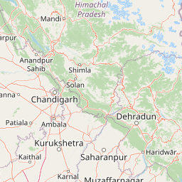
Map view of Simbalbara National Park

Use this park location map to pinpoint Simbalbara National Park in India, understand its exact geographic position, and read its mapped placement within the surrounding landscape more clearly.

Pigeon | © OpenStreetMap contributors

Location context for Simbalbara National Park

Himachal PradeshSirmour District
Park atlas

Trace the regional spread of protected areas and compare geographic features in India's Himalayan foothills.

Explore Nearby Protected Areas, Forests, and Wildlife Habitats Beyond Simbalbara National Park

Continue your exploration of India's conservation landscapes by browsing other national parks and protected areas geographically relevant to Simbalbara National Park. Discover diverse forest ecosystems, wildlife habitats, and regional park geography to understand the broader context of protected areas in the Himalayan foothills.
National parkHaryana
About 9.8 km away#1 closest

Southeast

Kalesar National Park: Exploring Haryana's Unique Sal Forest Protected Landscape

Discover mapped terrain and regional geography within the Shivalik foothills.

Kalesar National Park, located in the Shivalik foothills of Haryana, is a crucial protected area renowned for its natural sal forest, a rare ecological feature in the state. Spanning approximately 53 square kilometers, the park's diverse terrain offers insights into regional geography and conservation, serving as a vital habitat for leopards and a corridor for wild elephants. Its mapped boundaries encompass a unique landscape that contrasts sharply with surrounding agricultural lands, making it a significant point of study for protected-area enthusiasts.

Area
53 km²
Established
2003
IUCN
IV
Relief
Highland
Wildlife reserveUttarakhand
About 18 km away#2 closest

East

Asan Conservation Reserve: Protected Wetland and Reservoir Geography in Uttarakhand

Mapping the landscape of North India's premier Ramsar site

Located in the Doon Valley of Uttarakhand, Asan Conservation Reserve creates a distinct natural refuge within a working hydrological system. This wildlife reserve features shallow reservoir basins and marshy shorelines, providing a key corridor for migratory bird species and serving as an anchor for regional conservation efforts.

Area
4 km²
Established
1967
Water
Water-dominated
Season
Year-round
Wildlife reserveHimachal Pradesh
About 19 km away#3 closest

North

Renuka Sanctuary: Protected Wildlife Reserve and Ramsar Wetland Site in Himachal Pradesh

Ecological catchment and forest basin in the low Himalayan hills

Renuka Sanctuary is a dedicated wildlife reserve in Himachal Pradesh defined by the expansive Renuka Lake and its surrounding dry deciduous forest cover. This Ramsar wetland area protects the critical catchment zone of the state's largest natural lake, offering a unique intersection of conservation land and culturally significant natural terrain.

Area
4.028 km²
Water
Major water bodies
National parkUttarakhand
About 79 km away#4 closest

Southeast

Rajaji National Park: Uttarakhand National Park and Tiger Reserve Landscape

Sivalik Hills geography and protected area context

Rajaji National Park is a vital protected landscape situated in the Uttarakhand region of India, recognized as both a national park and a tiger reserve. Its territory spans across the Sivalik Hills, offering a diverse terrain characterized by deciduous forests and riparian ecosystems. The park's location along the Ganga river significantly influences its ecology, providing a unique geographic context for its protected status and wildlife significance.

Area
820.5 km²
Established
1983
IUCN
II
Relief
Highland
National parkUttarkashi District
About 107 km away#5 closest

Northeast

Govind Pashu Vihar National Park: Exploring India's Uttarkashi District Protected Landscape

Mapped protected area boundaries and regional geographic context.

Investigate Govind Pashu Vihar National Park, a key protected area in Uttarkashi District, India. This resource provides essential information on its designation as a national park, focusing on its geographic spread, mapped landscape features, and its placement within the regional atlas for comprehensive discovery. Understand the distinctiveness of this protected land's terrain and its role in conservation geography.

Area
958 km²
Established
1955
IUCN
II
Relief
Mountain
Protected areaPunjab
About 113 km away#6 closest

Northwest

Ropar Wetland: Geographic Mapping of a Punjab Freshwater Protected Landscape

Riverine and lacustrine geography in the Shivalik foothills.

Ropar Wetland stands as a significant protected area within the Punjab region, defined by its man-made reservoir origin and subsequent ecological maturation. This site serves as a vital transition point between the Shivalik hills and the Indo-Gangetic plains, hosting a dense variety of marshland, forest, and open water habitats that support rare reptile species and extensive bird populations.

Area
13.65 km²
Established
1952
Relief
Lowland
Climate
Subtropical
Wildlife reserveUttar Pradesh
About 118 km away#7 closest

Southeast

Haiderpur Wetland Wildlife Reserve: Exploring the Ganges Floodplain and Migratory Flyways

A critical Ramsar-designated freshwater marshland within Uttar Pradesh

Spanning over 6,900 hectares, Haiderpur Wetland represents a significant protected area where open water and floodplain terrain create a haven for migratory birds along the Central Asian Flyway. The reserve, positioned within the broader Hastinapur Wildlife Sanctuary, offers a detailed look at how artificial water control impacts local riverine biodiversity and landscape development in North India.

Area
69 km²
Established
1984
Water
Water-dominated
National parkHimachal Pradesh
About 133 km away#8 closest

North

Great Himalayan National Park: Protected Landscape and Mapped Geography

Explore this national park's dramatic elevation and rich biodiversity.

Great Himalayan National Park is a vital protected area within India's Himachal Pradesh, celebrated for its exceptional biodiversity and dramatic mountain geography. This national park encompasses a remarkable range of elevations, creating distinct ecological zones from lower forest elevations to high alpine meadows and glacial zones. Its significance as a mapped protected landscape makes it essential for understanding regional natural heritage and conservation efforts within the Himalayas.

Area
1,171 km²
Established
1984
IUCN
II
Relief
Mountain

Common questions about visiting, size, designation, and location context for Simbalbara National Park

Simbalbara National Park FAQs for park facts, access, geography, and protected area context

Find quick answers about Simbalbara National Park, including protected-area facts, park geography, trail and visitor context, and how the park fits into its surrounding country and regional landscape.
MoriAtlas Explorer

Continue Your Protected Areas Search Across the Global Atlas

Deepen your exploration by continuing the structured search for national parks and protected areas worldwide. Utilize the comprehensive filtering capabilities to compare different conservation landscapes and refine your understanding of global park geography. Discover more about the distribution and characteristics of protected natural areas.

Global natural geography