

Mori Atlas logo
National parkCampbell Bay National Park

Discover the mapped geography and protected landscape boundaries of this island national park.

Campbell Bay National Park: National Park in the Andaman and Nicobar Islands

Campbell Bay National Park represents a significant protected land within the archipelago of the Andaman and Nicobar Islands. This page offers an atlas-focused view of the park, detailing its geographic scope and place within the broader regional context. Users can explore the park's mapped boundaries and understand its identity as a protected natural landscape, serving as a key entry point for detailed geographic and map-based discovery.

National ParkTropical IslandGreat NicobarAndaman and Nicobar IslandsBiosphere ReserveOld-Growth Forest

Campbell Bay National Park

National park

Park overview

Structured park overview, official facts, and landscape profile for Campbell Bay National Park

Campbell Bay National Park park facts, protected area profile, and essential visitor context

Review the core facts for Campbell Bay National Park, including designation, size, terrain, visitor scale, habitats, and operating context in one park-focused overview.

About Campbell Bay National Park

Campbell Bay National Park protects a substantial portion of Great Nicobar Island, the largest and most ecologically significant island in the Nicobar archipelago. Located in the eastern Indian Ocean roughly midway between the Indian mainland and the island of Sumatra, Great Nicobar occupies a strategic position in the biogeographic boundary between the Indian subcontinent and Southeast Asia. The national park encompasses diverse terrain ranging from coastal wetlands and mangrove fringes through lowland evergreen forest to steeper hill slopes in the island's interior.

The park's establishment in 1992 reflected growing recognition of Great Nicobar's exceptional biodiversity value and the need to protect its forests from development pressures. As part of the Great Nicobar Biosphere Reserve, it functions within a three-zone conservation framework that includes core protected areas, a buffer zone with limited human activity, and a surrounding transition zone accommodating sustainable traditional use by local communities. This designation reflects the park's dual role in biodiversity preservation and sustainable development.

The park's relative remoteness has helped preserve its natural character, though it faces ongoing challenges from climate change, particularly rising sea levels and storm intensification that threaten low-lying coastal ecosystems. Visitor infrastructure remains limited, with access constrained by the island's isolated location and the need to protect sensitive ecological communities. Those who do visit experience a landscape fundamentally different from mainland Indian protected areas, with island-endemic species,Ocean-facing coastlines, and a sense of geographic isolation that defines the Nicobar experience.

Quick facts and research context for Campbell Bay National Park

Campbell Bay National Park occupies the central-western portion of Great Nicobar Island in the Union Territory of Andaman and Nicobar Islands, India. The park was formally designated in 1992 under India's national parks framework and holds IUCN Category II protected area status. At approximately 426 square kilometers, it represents one of the larger protected areas in the island chain. The park forms the northern half of the Great Nicobar Biosphere Reserve, with Galathea National Park sharing the southern portion of the reserve. The climate is consistently humid and warm year-round, characteristic of low-latitude tropical island environments.

Protection and recognition

Investigating the designated protection scope and official conservation status established in 1992

Campbell Bay National Park Protection Status and Terrestrial Designation

Campbell Bay National Park features a documented terrestrial protection status established in 1992 to preserve its specific island geography. National park databases track official designation years and terrestrial protection scopes to help researchers map the global footprint of protected wilderness.

Protection details

Protection scope
Terrestrial
Designated year
1992
Park context

Deeper park guide and search-rich context for Campbell Bay National Park

Campbell Bay National Park history, landscape, wildlife, and travel context

Explore Campbell Bay National Park through its history, landscape character, ecosystems, wildlife, conservation priorities, cultural context, and seasonal travel timing in a structured park guide built for atlas discovery and search intent.

Why Campbell Bay National Park stands out

Campbell Bay National Park is best known for protecting one of the most biologically diverse tropical island ecosystems in India. The park preserves extensive old-growth forest cover on Great Nicobar, an island whose isolation has produced distinctive endemic species found nowhere else on Earth. Its coastal mangroves, evergreen forests, and interior hill systems provide critical habitat for Nicobar's unique wildlife, including several endemic bird species and mammals adapted to island forest environments. The park also serves as a conservation anchor for the broader Great Nicobar Biosphere Reserve, India's southernmost biosphere reserve encompassing both marine and terrestrial protected zones.

Campbell Bay National Park history and protected-area timeline

Campbell Bay National Park was officially designated as a national park in 1992 through formal government notification, placing it within India's system of legally protected areas under the Wildlife Protection Act. The park's creation came as part of a broader expansion of India's protected area network during the 1980s and 1990s, driven by growing international attention to tropical forest conservation and biodiversity loss. Great Nicobar had already been recognized for its ecological significance, and the establishment of the Great Nicobar Biosphere Reserve provided an overarching framework for coordinated conservation across multiple protected zones.

Prior to formal protection, Great Nicobar's forests had been subject to limited commercial extraction and shifting cultivation by local communities. The park designation imposed legal restrictions on land-use change and commercial exploitation within its boundaries, though traditional fishing and limited subsistence activities by indigenous communities continued in surrounding areas. The creation of Galathea National Park to the south, separated by a forest buffer zone, created a connected conservation landscape across the island's southern half.

Management of the park falls under the jurisdiction of the Andaman and Nicobar Islands' forest department, with coordination through the broader biosphere reserve management framework. Research and monitoring activities have been conducted periodically, though the park's remote location has limited systematic ecological study compared to more accessible protected areas in India.

Campbell Bay National Park landscape and geographic character

The landscape of Campbell Bay National Park reflects its island setting on Great Nicobar, one of the larger islands in the Nicobar chain. The terrain rises from coastal mangrove wetlands and beach strand vegetation in the low-lying zones toward interior hills that reach several hundred meters elevation. Coastal areas feature characteristic beach forests, while the park's interior holds dense evergreen forest dominated by tall trees, epiphytes, and the dense understory typical of humid tropical forests.

The park's western boundary traces the island's coastline along the Andaman Sea, where coastal processes have created narrow beaches, tidal flats, and mangrove stands that transition into terrestrial forest. Inland, the terrain becomes progressively hillier as the island's central ridge system runs roughly north-south through the park. Streams and small watercourses drain from these uplands, maintaining moisture in the forest understory and supporting wetland pockets within the forest matrix.

The vegetation pattern reflects the tropical humid climate, with evergreen species dominant throughout most of the park. Forest structure is complex, with multiple canopy layers, numerous lianas, and diverse epiphytic growth on tree trunks and branches. The twelve-kilometer buffer zone separating Campbell Bay from Galathea National Park maintains forest connectivity across the island while providing a management buffer between the two protected areas.

Campbell Bay National Park ecosystems, habitats, and plant life

The ecological character of Campbell Bay National Park is defined by its position within the Nicobar islands bioregion, a biogeographic zone of exceptional importance bridging Indian and Southeast Asian biodiversity. The park's forests represent the best-preserved example of lowland and hill forest on Great Nicobar, supporting plant communities that include numerous species endemic to the Nicobar islands themselves. These endemic species, isolated on the island for geological time, have evolved distinctive characteristics that distinguish them from mainland Indian and Sumatran relatives.

The park's habitats span multiple vegetation types, from coastal mangrove systems through beach forest and lowland evergreen formations to hill forest at higher elevations. This habitat mosaic supports a correspondingly diverse community of invertebrates, birds, mammals, and other organisms. The Great Nicobar Biosphere Reserve designation reflects international recognition that the island's ecosystems warrant coordinated protection across both terrestrial and marine environments.

Climate in the park is uniformly humid and warm, with little seasonal temperature variation typical of equatorial island settings. Annual rainfall is substantial, supporting the evergreen forest character and maintaining moisture throughout the ecosystem. This climatic constancy means the park lacks the dramatic seasonal changes seen in higher-latitude protected areas, maintaining its green, lush character year-round.

Campbell Bay National Park wildlife and species highlights

Wildlife in Campbell Bay National Park reflects the distinctive Nicobar island biota, which shares elements with both Indian and Southeast Asian faunal communities while also supporting species found nowhere else. Birdlife is particularly notable, with several species endemic to the Nicobar islands recorded within the park, including the Nicobar pigeon and various endemic passerines adapted to island forest environments. The avifauna diversity reflects the park's position as a biogeographic crossroads and the quality of its forest habitat.

Mammal diversity includes several species typical of island forests, though the smaller land mammal community reflects the reduced mammalian diversity typical of isolated islands compared to mainland continental settings. Bats, including fruit bats and insectivorous species, represent the most diverse mammalian group, utilizing the forest for roosting and foraging. The park's streams and coastal areas support amphibians and reptiles adapted to tropical island conditions.

The invertebrate community remains poorly documented but is likely exceptionally diverse, as is typical of tropical forest ecosystems. Insects, spiders, and other invertebrates form the base of the food web supporting vertebrate predators and constitute a significant portion of the park's biodiversity. Marine turtles occasionally nest on coastal beaches, linking the terrestrial park with the surrounding marine environment.

Campbell Bay National Park conservation status and protection priorities

Campbell Bay National Park plays a critical role in India's protected area system as one of the few large-scale conservation areas preserving tropical island forest ecosystems. Its inclusion in the Great Nicobar Biosphere Reserve provides an integrated framework for protecting both the park's terrestrial values and the surrounding marine environment, recognizing that island conservation must address coastal and oceanic systems alongside inland areas. The biosphere reserve model also acknowledges the need to balance strict protection with sustainable use in the broader landscape.

The park's conservation significance is magnified by Great Nicobar's geographic isolation and the evolutionary distinctiveness of its biota. Island ecosystems globally are recognized as disproportionately important for biodiversity conservation because endemic species, isolated by oceanic barriers, cannot survive anywhere else. Campbell Bay National Park preserves populations of these endemic species within a protected landscape, maintaining the evolutionary processes that produced them.

Challenges facing the park include climate change impacts on low-lying coastal areas, potential sea-level rise affecting mangrove ecosystems and nesting beaches, and the inherent vulnerability of island ecosystems to introduced species and diseases. Management priorities focus on maintaining ecological integrity, supporting research to better document biodiversity, and building capacity for adaptive management in the face of emerging threats.

Campbell Bay National Park cultural meaning and human context

Campbell Bay National Park exists within a landscape where indigenous communities maintain historical connections to the land and sea surrounding the protected area. The Nicobarese people, the indigenous inhabitants of the Nicobar Islands, have historically lived in proximity to the forests and coastlines now within and adjacent to the park. Their traditional land-use practices, including selective resource gathering and coastal fishing, are recognized within the biosphere reserve framework that governs the broader landscape.

The park takes its name from Campbell Bay, a settlement on Great Nicobar that represents one of the few population centers in the island's interior. This human presence predates formal protection and continues within the broader biosphere reserve structure, reflecting the reality that conservation in populated island landscapes must accommodate human communities alongside wildlife protection.

Cultural context also includes the strategic significance of Great Nicobar in India's maritime positioning, with the island's location at the mouth of the Malacca Strait giving it geopolitical importance. This dimension occasionally influences discussions about development and conservation trade-offs, though the park's protected status has remained consistent since designation.

Top sights and standout views in Campbell Bay National Park

Campbell Bay National Park offers a rare opportunity to experience well-preserved tropical island wilderness at India's southern geographic limit. The park protects extensive old-growth forest that represents the best remaining examples of Nicobar island ecosystems, with the diversity and endemism those ecosystems support. Visitors can explore mangrove-lined coastlines, walk beneath towering trees in evergreen forest, and observe bird species found nowhere else on Earth.

The park's position within the Great Nicobar Biosphere Reserve creates opportunities to understand island conservation at multiple scales, from species protection through habitat management to regional biosphere planning. The relative remoteness and limited development of the park preserve a sense of wild, unmodified nature increasingly rare in populated regions. For those seeking to experience the distinctive character of India's island frontier, Campbell Bay provides access to landscapes fundamentally different from the country's mainland protected areas.

Best time to visit Campbell Bay National Park

The best time to visit Campbell Bay National Park is during the dry season from October through April, when rainfall is reduced and weather conditions favor outdoor exploration. The island's tropical climate means that even the drier months remain warm and humid, with temperatures remaining consistently elevated throughout the year. The post-monsoon period typically offers clearer skies and more comfortable conditions for wildlife observation and nature walks.

The monsoon season from May through September brings heavier rainfall, increased humidity, and rougher sea conditions that can affect access to the island and limit outdoor activities within the park. Those visiting during this period should expect wet conditions and potential disruptions to travel plans. Year-round warm temperatures mean that no season offers a dramatic contrast in landscape appearance, with the forest maintaining its evergreen character throughout the calendar year.
Monthly climate preview

Long-term representative point measurements tracking monthly temperature ranges and rainfall patterns

Campbell Bay National Park Climate Normals, Annual Temperature and Precipitation Rhythm

Campbell Bay National Park records consistent long-term mean temperatures between 27.31 degrees Celsius and 28.57 degrees Celsius alongside varying monthly precipitation rates across the representative coordinate. Analyzing the complete twelve-month climatology profile reveals detailed seasonal variations in temperature and precipitation normals for this protected area.
Annual mean28 °C
27 °C29 °C
Jan27°
Feb28°
Mar28°
Apr29°
May29°
Jun28°
Jul28°
Aug28°
Sep27°
Oct27°
Nov27°
Dec27°
Warmest month
April

28.6 °C

Coolest month
October

27.3 °C

Wettest month
November

7.2 mm/day

Driest month
February

2 mm/day

Park location guide

Geography guide, regional context, and park location map for Campbell Bay National Park

Campbell Bay National Park park geography, regions, and map view in India

Understand where Campbell Bay National Park sits in India through a broader geographic reading of the surrounding landscape, nearby location context, and its mapped position within the national park landscape.

How Campbell Bay National Park fits into India

India is a South Asian country bordered by the Indian Ocean, Arabian Sea, and Bay of Bengal. It shares land borders with Pakistan, China, Nepal, Bhutan, Bangladesh, and Myanmar. The country has a population of over 1.4 billion people and operates as a federal parliamentary republic with its capital in New Delhi.

Wider geography shaping Campbell Bay National Park in India

India occupies the Indian subcontinent in South Asia, bordered by the Arabian Sea to the southwest, the Bay of Bengal to the southeast, and the Indian Ocean to the south. It shares land borders with Pakistan to the west, China, Nepal, and Bhutan to the north, and Bangladesh and Myanmar to the east. The territory also includes the Andaman and Nicobar Islands in the Indian Ocean.

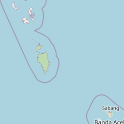
Map view of Campbell Bay National Park

Use this park location map to pinpoint Campbell Bay National Park in India, understand its exact geographic position, and read its mapped placement within the surrounding landscape more clearly.

Pigeon | © OpenStreetMap contributors

Location context for Campbell Bay National Park

Andaman and Nicobar Islands
Park atlas

Compare other protected landscapes, tracing geographic spread across Great Nicobar Island and India's island frontier

Discover Other National Parks and Protected Areas Near Campbell Bay National Park on Great Nicobar

After exploring Campbell Bay National Park, browse other national parks and protected areas to trace the geographic spread of India's island ecosystems. This allows for a deeper understanding of regional conservation landscapes, comparing island forest types and coastal protected zones across the Nicobar chain.
National parkAndaman and Nicobar Islands
About 22 km away#1 closest

South

Galathea National Park: National Park Protected Landscape and Geography

Explore mapped boundaries within the Andaman and Nicobar Islands.

Galathea National Park serves as a vital protected landscape, contributing to the rich geographic tapestry of the Andaman and Nicobar Islands. This canonical MoriAtlas entry provides essential atlas-driven details about the park's identity as a national park. Focus is placed on its mapped presence and regional geographic context, allowing for structured exploration of its protected status and landscape features for users interested in detailed geographic and conservation mapping.

Area
110 km²
Established
1992
IUCN
II
Relief
Lowland
Watercolor illustration of a coastal landscape with rolling hills, green vegetation, pink flowers, and a body of water in the background
National parkThailand
About 460 km away#2 closest

East

Mu Ko Similan National Park: Thailand's Andaman Sea Marine National Park and Archipelago Geography

Mapped island terrain, coral reef atlas, and marine protected landscape identity.

Mu Ko Similan National Park is a significant protected area in Thailand, renowned for its island archipelago geography in the Andaman Sea. The park features striking granite boulder formations above sea level and incredibly rich coral reef ecosystems below, making it a key location for marine atlas exploration. Users can discover the mapped park boundaries, the unique natural terrain of the Similan Islands, and the vital role of this protected landscape in regional marine conservation efforts, offering a detailed geographic perspective.

Area
140 km²
Established
1982
IUCN
II
Visitors
912K annual
National parkIndonesia
About 501 km away#3 closest

Southeast

Gunung Leuser National Park: A Critical Protected Landscape in Indonesia's Barisan Mountains

Discover its mountainous terrain and primate conservation significance.

Gunung Leuser National Park is a significant protected area in Indonesia, encompassing 3,208 square kilometers of diverse tropical rainforest and rugged mountainous terrain within the Barisan mountain range. Its designation as a national park highlights its role in preserving critical ecosystems, including one of the last remaining habitats for the Sumatran orangutan. This atlas entry provides a geographic overview of the park's landscape, focusing on its protected boundaries and ecological importance within the region.

Area
3,208 km²
Established
1980
IUCN
II
Relief
Mountain
National parkIndia
About 505 km away#4 closest

North

Mahatma Gandhi Marine National Park: India National Park Protected Landscape and Geography

Explore mapped boundaries and regional geographic context.

Gain a detailed understanding of Mahatma Gandhi Marine National Park, a designated national park in India. This entry focuses on its protected area status, the mapped extent of its natural landscape, and its significance within India's diverse geography. Discover the park's spatial context and contribution to the nation's protected lands through an atlas-focused lens, providing essential geographic details for informed exploration.

Area
281.5 km²
Established
1983
IUCN
II
Relief
Lowland
National parkPhuket Province
About 512 km away#5 closest

East

Sirinat National Park: Phuket Province Protected Coastal Landscape and Marine Atlas

Mapped boundaries, beach forests, and sea turtle nesting sites.

Sirinat National Park offers a unique opportunity to explore a protected coastal geography on Phuket Island. This national park preserves critical beach forest ecosystems, extensive shorelines like Hat Mai Khao, vital sea turtle nesting grounds, and surrounding marine environments including coral reefs and mangrove habitats. Its designation as a protected area provides essential context for understanding the natural landscape and its ecological significance within Thailand's regional geography.

Area
90 km²
Established
1981
IUCN
II
Visitors
51.2K annual
National parkPhang Nga Province
About 515 km away#6 closest

East

Khao Lampi, Hat Thai Mueang National Park: Mountain Rainforest and Andaman Coast Atlas

Explore the mapped geography and protected boundaries.

Delve into Khao Lampi, Hat Thai Mueang National Park, a key protected area within Phang Nga Province, Thailand. This unique national park showcases a striking dichotomy: the lush, waterfall-adorned slopes of the Khao Lampi mountains contrast with the pristine Andaman Sea coastline of Hat Thai Mueang beach, a critical site for sea turtle nesting. The park's mapped landscape encompasses dense tropical rainforest, significant mangrove ecosystems, and important natural terrain, offering a comprehensive view of diverse protected environments for atlas exploration.

Area
72 km²
Established
1986
IUCN
II
Visitors
50.5K annual
National parkThailand
About 519 km away#7 closest

Northeast

Mu Ko Surin National Park: Mapped Marine Protected Area in Thailand's Andaman Sea

Explore unique island geography and vibrant coral reef landscapes.

Mu Ko Surin National Park is a national park comprising a series of islands within Thailand's Andaman Sea, recognized for its exceptional marine biodiversity and well-preserved coral reefs. This protected area showcases a distinctive landscape where dense tropical forests meet extensive underwater ecosystems, offering a prime example of coastal natural geography. Understanding Mu Ko Surin National Park through its mapped boundaries and ecological significance provides valuable insight into Thailand's protected natural heritage and its role in regional conservation.

IUCN
II
Scope
Marine
National parkAndaman and Nicobar Islands
About 524 km away#8 closest

North

Mount Harriet National Park: National Park Mapping and Protected Landscape Identity

Explore its endemic biodiversity and mountain forest terrain.

Mount Harriet National Park provides a deep dive into a unique protected landscape, offering detailed insights into its geography, terrain, and ecological significance within the Andaman and Nicobar Islands. As a national park, it showcases a remarkable combination of mountainous forest ecosystems and coastal environments, serving as a vital habitat for numerous endemic species. Understanding its mapped boundaries and regional geographic context reveals why this protected area is a key point of interest for atlas-based natural landscape exploration.

Area
46.62 km²
Established
1979
IUCN
II
Relief
Mountain

Common questions about visiting, size, designation, and location context for Campbell Bay National Park

Campbell Bay National Park FAQs for park facts, access, geography, and protected area context

Find quick answers about Campbell Bay National Park, including protected-area facts, park geography, trail and visitor context, and how the park fits into its surrounding country and regional landscape.
MoriAtlas Explorer

Continue Your Protected Areas Search Across the Global Atlas

Deepen your exploration by continuing the structured search for national parks and protected areas worldwide. Utilize the comprehensive filtering capabilities to compare different conservation landscapes and refine your understanding of global park geography. Discover more about the distribution and characteristics of protected natural areas.

Global natural geography

