Mori Atlas logo
National parkEndau-Rompin National Park

Discover the unique mapped geography and 248-million-year-old rock formations of this vital conservation area.

Endau-Rompin National Park: Malaysia's Ancient Tropical Rainforest Protected Landscape in Johor

(Taman Negara Endau-Rompin)

Endau-Rompin National Park, nestled in Malaysia's Johor region, represents one of the planet's oldest tropical rainforest complexes, grounded in geological formations dating back approximately 248 million years. This national park is crucial for understanding regional geography and the distribution of protected lands, featuring a rugged, mountainous terrain carved by the Endau and Rompin rivers. Its dense jungle cover and ancient bedrock provide essential habitat, offering a unique window into prehistoric ecosystems and the conservation of vital natural landscapes.

Tropical RainforestASEAN Heritage ParkPeninsular MalaysiaOld-Growth ForestMountainous TerrainWildlife Conservation

Endau-Rompin National Park

National park

Park overview

Structured park overview, official facts, and landscape profile for Endau-Rompin National Park

Endau-Rompin National Park park facts, protected area profile, and essential visitor context

Review the core facts for Endau-Rompin National Park, including designation, size, terrain, visitor scale, habitats, and operating context in one park-focused overview.

About Endau-Rompin National Park

Endau-Rompin National Park represents one of the most ecologically significant protected areas in Southeast Asia, encompassing a vast tract of ancient tropical rainforest within the southern foothills of the Tenasserim Hills. The park straddles the border between Johor and Pahang states in Peninsular Malaysia, spanning across the Segamat and Mersing Districts of Johor and the Rompin District of Pahang. This strategic location within a mountainous massif creates a unique ecological corridor that connects lowland forest ecosystems with higher elevation habitats, supporting remarkable biodiversity across multiple ecological zones. The park's extensive trail network of approximately 26 kilometers allows visitors to explore its diverse landscapes, though access is seasonally restricted during the monsoon months when heavy rainfall makes the terrain hazardous. The park's establishment in 1993 marked a significant milestone in Malaysian conservation history as only the second national park to be proclaimed by the Malaysian government, following the creation of Taman Negara. This designation came after decades of gradual protection efforts that began with the forest reserve status granted to the Endau-Kluang forest complex in 1933 and subsequent expansions in 1972 to include the Lesong forest reserve in Pahang. The 2022 ASEAN Heritage Park designation further elevates the international recognition of this area's exceptional natural value.

Quick facts and research context for Endau-Rompin National Park

Endau-Rompin National Park covers 870 square kilometers of protected tropical rainforest in southern Peninsular Malaysia, straddling the districts of Segamat and Mersing in Johor and Rompin in Pahang. The park was officially established in 1993 and is managed by the Johor Park Corporation. It features approximately 26 kilometers of hiking trails and contains Gunung Besar, the second-highest peak in Johor. The park isclosed to visitors during the monsoon season from November through March, and fishing is prohibited during September and October to protect species during their mating season. In 2022, Endau-Rompin was designated as an ASEAN Heritage Park, recognizing its outstanding ecological and conservation significance.

Protection and recognition

Verifying official terrestrial boundaries and the historical designation of the reserve.

Documented Protection Status and Designation of Endau-Rompin National Park

Established terrestrial designation records show Endau-Rompin National Park as a legally recognized protected area established in 2022. Analyzing official boundaries and designation history provides crucial geographic context for understanding regional conservation frameworks and land management.

Protection details

Protection scope
Terrestrial
Designated year
2022
Transboundary protection
No
Park context

Deeper park guide and search-rich context for Endau-Rompin National Park

Endau-Rompin National Park history, landscape, wildlife, and travel context

Explore Endau-Rompin National Park through its history, landscape character, ecosystems, wildlife, conservation priorities, cultural context, and seasonal travel timing in a structured park guide built for atlas discovery and search intent.

Why Endau-Rompin National Park stands out

Endau-Rompin National Park is best known for its status as one of the oldest tropical rainforest complexes on Earth, containing rock formations approximately 248 million years old. The park serves as a critical refuge for Malaysia's last remaining populations of several large mammal species, including the Malayan tiger, Asian elephant, and Malayan tapir. It was historically significant for maintaining the largest remaining population of the critically endangered Northern Sumatran rhinoceros on the Malay Peninsula, though the species is now considered extirpated from Malaysian wilds. The park also harbors endemic species found nowhere else on Earth, most notably the Gollum's toad (Ingerophrynus gollum), which is known only from this protected area.

Endau-Rompin National Park history and protected-area timeline

The scientific exploration of the Endau-Rompin region began in 1892 when H.W. Lake and Lieutenant H.J. Kelsall conducted the first comprehensive study of the area's natural resources and geography. Their findings provided the foundational knowledge that led to the forest complex of Endau-Kluang being gazetted as a forest reserve in 1933, establishing the earliest formal protection for this exceptional ecosystem. This initial protection was expanded in 1972 when the forest reserve was enlarged to include the Lesong forest reserve in Pahang, creating a more comprehensive conservation framework for the region. In the same year, the federal government proposed declaring approximately 2,000 square kilometers of the forest complex as a national park, though no legal mechanism existed at that time to establish such a protected area. The Malaysian Parliament addressed this gap in 1980 by passing the National Parks Act, creating the necessary legal framework for national park designation. However, jurisdictional disputes between federal and state authorities delayed the actual creation of the national park for several years. In 1985, the Department of Wildlife and National Parks proposed an alternative conservation approach, suggesting the area be gazetted as a wildlife sanctuary specifically to protect the critically endangered Sumatran rhinoceros population. This proposal reflected the park's importance as a last refuge for this highly threatened species. The park's significance was formally recognized internationally in 2022 when it was declared an ASEAN Heritage Park, acknowledging its outstanding universal value as an ecological and biodiversity resource.

Endau-Rompin National Park landscape and geographic character

The terrain of Endau-Rompin National Park is dominated by the rugged, forested slopes of a mountainous massif within the southern foothills of the Tenasserim Hills, one of the major mountain systems of mainland Southeast Asia. This mountainous setting creates a varied topography of steep ridges, deep valleys, and undulating hills covered in dense tropical vegetation. The park's name derives from its two principal river systems, the Endau River and the Rompin River, which have carved valleys through the landscape and continue to shape the terrain. Additional waterways including the Segamat River, Selai River, and Jasin River provide additional hydrological diversity throughout the park. One of the park's most remarkable geological features is the presence of ancient rock formations dating back approximately 248 million years, placing them in the Late Permian geological period. These ancient geological structures represent some of the oldest exposed rock formations in the region and form distinctive landscape features within the park. The highest peak within the park is Gunung Besar, which at approximately 1,200 meters above sea level represents the second-highest mountain in Johor state, providing dramatic elevation changes across the park's extent.

Endau-Rompin National Park ecosystems, habitats, and plant life

Endau-Rompin National Park contains one of the oldest and most biodiverse tropical rainforest ecosystems in the world, with vegetation communities that have persisted through millions of years of climatic and geological change. The ancient rock formations underlying the forest, dating to approximately 248 million years ago, have provided stable geological substrate for the evolution of unique forest communities. The park's location within the Tenasserim Hills places it at a biogeographic crossroads, receiving influences from both continental Asian and island Southeast Asian biota. The diverse topography creates multiple habitat zones ranging from lowland dipterocarp forests through to montane vegetation at higher elevations, each supporting distinct ecological communities. Rivers and streams throughout the park provide riparian habitats and serve as movement corridors for aquatic and semi-aquatic species, while the forest canopy supports complex arboreal communities. The combination of ancient geological stability and continued forest cover has allowed these ecosystems to develop remarkable levels of species richness and endemism.

Endau-Rompin National Park wildlife and species highlights

The mammalian fauna of Endau-Rompin National Park is exceptionally diverse, with the park serving as a critical refuge for several species of significant conservation concern. The large predator community includes the Malayan tiger, Indochinese leopard, Clouded leopard, Asian golden cat, Leopard cat, and Marbled cat, representing one of the most complete assemblages of felids in Peninsular Malaysia. Herbivorous megafauna include the Asian elephant and Malayan tapir, both species facing significant population pressures across their ranges. The park historically supported the largest remaining population of the critically endangered Northern Sumatran rhinoceros on the Malay Peninsula, though this species is now considered extirpated from the wild throughout Malaysia. Smaller mammals include the Sunbear, various primate species such as the Long-tailed macaque, Pig-tailed macaque, Dusky leaf monkey, and Banded Langur, and diverse ungulates including Barking deer, Sambar deer, and both Greater and Lesser mouse deer. Wild pigs are represented by the Bornean bearded pig and Banded pig. The park also supports a unique amphibian fauna, most notably the Gollum's toad (Ingerophrynus gollum), a species described scientifically from this park and known from no other location on Earth.

Endau-Rompin National Park conservation status and protection priorities

Endau-Rompin National Park holds exceptional conservation significance as one of the last extensive tracts of primary tropical rainforest in southern Peninsular Malaysia and as a critical habitat for multiple threatened species. The park's designation as an ASEAN Heritage Park in 2022 recognizes its outstanding universal value as an ecological resource of regional and global importance. The protection of this forest ecosystem preserves habitat corridors essential for the survival of large mammals including tigers, elephants, and tapirs, whose populations have been fragmented across much of their former range by agricultural expansion and infrastructure development. The park's history with Sumatran rhinoceros conservation reflects both the challenges facing mega-herbivores in Southeast Asia and the complexity of transboundary conservation efforts. The establishment of the national park in 1993 represented the culmination of decades of advocacy and negotiation between federal and state authorities, demonstrating the institutional commitment required to protect large landscape-scale ecosystems. Continued management of the park requires balancing ecological protection with sustainable visitation, as evidenced by seasonal closures during the monsoon period and temporary fishing restrictions during peak reproductive seasons for aquatic species.

Endau-Rompin National Park cultural meaning and human context

The park derives its name from the Endau and Rompin rivers, which flow through the protected area and have historically supported local communities in the surrounding region. The two official entry points to the park, Kampung Peta along the eastern boundary in Mersing District and the Selai entrance at the southwestern boundary in Segamat District, reflect the human communities whose relationship with this landscape predates formal protected area designation. The park's location spans the border between Johor and Pahang states, placing it within a region of historical administrative significance. The local Malay communities in the surrounding areas have maintained traditional relationships with the forest resources, though the specific indigenous connections to this particular protected area are less extensively documented than in some other Malaysian parks. The closure of the park during monsoon season reflects both practical management considerations and an acknowledgment of the challenging conditions that the landscape presents during these months.

Top sights and standout views in Endau-Rompin National Park

Endau-Rompin National Park offers visitors access to one of the world's oldest tropical rainforest ecosystems, with ancient geological formations providing a dramatic backdrop to the dense forest cover. The park's position within the Tenasserim Hills creates excellent opportunities for hikers to explore approximately 26 kilometers of trails through varied terrain, with Gunung Besar offering panoramic views from its summit as the second-highest peak in Johor. The diversity of large mammals present, including multiple felid species, elephants, and tapirs, makes the park significant for wildlife viewing and ecological study. The presence of endemic species such as the Gollum's toad, found nowhere else on Earth, demonstrates the unique evolutionary heritage preserved within this protected area. The designation as an ASEAN Heritage Park in 2022 reflects the international recognition of this area's outstanding conservation value.

Best time to visit Endau-Rompin National Park

The optimal time to visit Endau-Rompin National Park falls outside the monsoon season, with the dry months from April through October offering the most favorable conditions for exploration and wildlife viewing. The park is closed to visitors from November through March due to monsoon conditions that create hazardous trail conditions and increased risk of flash floods in the river valleys. Fishing is prohibited during September and October to protect species during their mating season, reflecting the park's conservation-oriented approach to visitor management. The dry season provides more comfortable temperatures for hiking and increases the likelihood of wildlife sightings as animals congregate around remaining water sources. Visitors planning trips should check current access conditions before traveling, as seasonal closures and restrictions may vary based on current conditions.

Monthly climate preview

Long-term representative temperature and precipitation averages for Johor

Endau-Rompin National Park Climate Normals and Monthly Weather Patterns

Endau-Rompin National Park experiences a sustained annual temperature rhythm alongside consistent monthly precipitation measured at a representative coordinate from 1991 to 2020. Examining the complete twelve-month climatology profile reveals deeper multi-year baseline averages across temperature highs, lows, and rainfall distributions.
Annual mean26 °C
25 °C27 °C
Jan25°
Feb25°
Mar26°
Apr27°
May27°
Jun27°
Jul26°
Aug26°
Sep26°
Oct26°
Nov26°
Dec25°
Warmest month
May

27.2 °C

Coolest month
January

25 °C

Wettest month
December

10.9 mm/day

Driest month
February

3.8 mm/day

Park location guide

Geography guide, regional context, and park location map for Endau-Rompin National Park

Endau-Rompin National Park park geography, regions, and map view in Malaysia

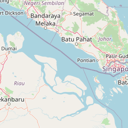
Understand where Endau-Rompin National Park sits in Malaysia through a broader geographic reading of the surrounding landscape, nearby location context, and its mapped position within the national park landscape.

How Endau-Rompin National Park fits into Malaysia

Malaysia is a federal constitutional monarchy located in Southeast Asia. The country consists of 13 states and three federal territories, divided by the South China Sea into Peninsular Malaysia on the Indochinese Peninsula and East Malaysia on the island of Borneo. With a population of over 34 million, it achieved independence from Britain in 1957 and became a modern federation in 1963. The country is recognized for its multicultural population, tropical climate, and significant economic role in the region.

Wider geography shaping Endau-Rompin National Park in Malaysia

Malaysia occupies a strategic position in Southeast Asia, split by the South China Sea into two distinct regions. Peninsular Malaysia lies on the Indochinese Peninsula, sharing a land border with Thailand to the north and maritime borders with Singapore, Vietnam, and Indonesia. East Malaysia occupies the northern portion of Borneo, sharing land borders with Brunei and Indonesia, and maritime borders with the Philippines and Vietnam. The country's terrain includes coastal plains, mountain ranges such as the Titiwangsa in the peninsula, and extensive tropical rainforests.

Map view of Endau-Rompin National Park

Use this park location map to pinpoint Endau-Rompin National Park in Malaysia, understand its exact geographic position, and read its mapped placement within the surrounding landscape more clearly.

Pigeon | © OpenStreetMap contributors

Location context for Endau-Rompin National Park

JohorPahang
Recorded earthquake history

Explore Historical Earthquake Records for Endau-Rompin National Park

Consult the historical archive of recorded seismic events associated with the region surrounding Endau-Rompin National Park. This MoriAtlas resource maps documented activity based on epicentre distance, providing a factual reference for geographic analysis within the protected landscape.

Endau-Rompin National Park Earthquake History

Catalogued events

1 event

Strongest magnitude

Magnitude 4

Most recent event

Aug 23, 2025

This history includes earthquakes recorded inside the park or within 50 km of its borders

Park atlas

Explore other protected areas, tracing the geographical context of tropical rainforests and ancient mountain terrain across Peninsular Malaysia.

Explore Nearby National Parks and Protected Areas Surrounding Endau-Rompin National Park

Discover other national parks and protected areas similar to Endau-Rompin National Park, exploring their mapped geography and conservation landscapes across Peninsular Malaysia. Compare adjacent tropical rainforests and ancient mountain systems to understand regional biodiversity patterns and broader protected area distribution.
Protected areaJohor
About 61 km away#1 closest

East

Rawa Island Protected Area: Coastal Geography and Island Landscape Context in Johor

A protected coral island within the Johor archipelago

Rawa Island serves as a significant protected landscape off the coast of Johor, Malaysia. Defined by its sharp contrast between rocky cliffs and clear, coral-filled waters, the island represents a crucial node in regional island geography. Delve into the spatial characteristics and environmental features of this South China Sea destination through our map-driven atlas framework.

Area
0.23 km²
Water
Water-dominated
Marine protected areaJohor
About 62 km away#2 closest

East

Besar Island Marine Protected Area: Coastal Geography and Protected Waters in Johor

Mapping the island's reef ecosystems and tropical landscape

Besar Island offers a distinct look at a small-scale marine protected area off the Johor coast. Its geography encompasses a transition from sandy beach fronts to a hilly, jungle-clad interior, all contained within a gazetted two-nautical-mile conservation zone. The surrounding waters support approximately 60 marine species, making this an essential case study for understanding protected marine habitats within the Babi Islands archipelago.

Area
4.77 km²
Relief
Upland
Climate
Tropical
Access
Easy access
Protected areaJohor
About 80 km away#3 closest

East

Tinggi Island Protected Area: Geography, Rainforest Terrain, and Johor Coastal Map

Mountainous forest meets extensive coral-rich coastal waters.

Located southeast of Mersing, Tinggi Island is defined by its dramatic silhouette and dense rainforest interior. The protected landscape stretches from the elevated peak of Mount Semundu down to a shoreline of white sand and coastal caves, creating a distinct marine and terrestrial environment unique to the Johor region.

Water
Major water bodies
Season
Year-round
Marine protected areaJohor
About 81 km away#4 closest

East

Sibu Island: Marine Protected Area and Coastal Landscape Analysis

Mapping the coral reefs and pyroclastic terrain of the Johor coast

Sibu Island is a protected marine area in the South China Sea, distinguished by its unique pyroclastic geology and surrounding coral reef ecosystems. This entry provides a structured look at the island's coastal geography, vegetation, and maritime boundaries off the coast of Mersing, Johor. Access detailed geographic context for this tropical landscape.

Area
4.05 km²
Established
1993
Relief
Lowland
Climate
Tropical
Wildlife reservePahang
About 90 km away#5 closest

East

Pulau Tioman Wildlife Reserve: Mapping Island Rainforests and Marine Boundaries

Protected island geography within the Pahang region

Covering the forested interior of Tioman Island, this wildlife reserve protects lowland and hill rainforest habitats that rise to Gunung Kajang. The area serves as a significant conservation landscape, bridging remote inland mountain terrain with vibrant coral-fringed coastlines in the South China Sea.

Area
136 km²
Established
1972
Relief
Mountain
Climate
Tropical
Protected areaJohor
About 100 km away#6 closest

East

Pemanggil Island Protected Landscape: Johor Offshore Geography and Island Topography

Mapping coastal features and inland terrain in the South China Sea.

Pemanggil Island serves as a significant geographic landmark within the Mersing cluster of Johor. This detailed atlas entry focuses on the island's structural composition, including its prominent central hill, the rocky interior, and coastal features such as Teluk Lancang. Understand the maritime geography and spatial character of this protected area within the context of the southern Malay Peninsula.

Area
8.82 km²
Relief
Upland
Climate
Tropical
Access
Moderate access
Biosphere reservePahang
About 102 km away#7 closest

North

Chini Lake Biosphere Reserve: Protected Freshwater Geography in Pahang, Malaysia

Examining the interconnected lake basins and tropical wetland terrain

Chini Lake is an essential protected freshwater system in Pahang, Malaysia, comprising a series of twelve connected lake basins and tropical forest margins. This landscape is a recognized UNESCO Biosphere Reserve, characterized by seasonal lotus blooms, peat-influenced wetlands, and deep cultural connections to the indigenous Jakun communities. Discover the geography and environmental context of this river-fed ecosystem.

Area
50.85 km²
Established
2019
Relief
Lowland
Climate
Tropical
Nature reserveMalaysia
About 103 km away#8 closest

Northwest

Pasoh Forest Reserve: Lowland Dipterocarp Protected Area in Peninsular Malaysia

Mapping tropical rainforest boundaries and ecological research zones

Situated in the interior of Peninsular Malaysia, Pasoh Forest Reserve protects a vital fragment of lowland dipterocarp rainforest. The reserve is globally recognized for its long-term forest dynamics plot, which tracks hundreds of thousands of trees to inform modern understanding of rainforest ecology. The mapped landscape displays clear boundaries between the dense protected forest and surrounding agricultural plantations, offering a distinct view of land use and tropical conservation.

Area
24.5 km²
Established
1987
Relief
Upland
Scope
Terrestrial

Common questions about visiting, size, designation, and location context for Endau-Rompin National Park

Endau-Rompin National Park FAQs for park facts, access, geography, and protected area context

Find quick answers about Endau-Rompin National Park, including protected-area facts, park geography, trail and visitor context, and how the park fits into its surrounding country and regional landscape.
MoriAtlas Explorer

Continue Your Protected Areas Search Across the Global Atlas

Deepen your exploration by continuing the structured search for national parks and protected areas worldwide. Utilize the comprehensive filtering capabilities to compare different conservation landscapes and refine your understanding of global park geography. Discover more about the distribution and characteristics of protected natural areas.

Global natural geography