
Why Karthala National Park stands out
Karthala National Park is best known for protecting the highest peak in Comoros, an active volcanic mountain with a dramatic caldera system. The park is particularly significant for its extraordinary endemism, supporting four bird species found exclusively on Mount Karthala's slopes: the Grand Comoro drongo, Humblot's flycatcher, Karthala scops owl, and Karthala white-eye. The mountain's moist evergreen forest and heathland zones harbor unique plant species including the giant heather Erica comorensis. The park also protects a Ramsar-designated wetland area, distinguishing it as a site of international conservation importance.
Karthala National Park history and protected-area timeline
Mount Karthala has a documented history of volcanic activity spanning more than a century, with over twenty eruptions recorded since the 19th century. The mountain's significance as a natural landmark and ecological area led to the designation of a Ramsar Wetland site covering 14,228 hectares in November 2006, recognizing the importance of the upper slopes and summit area. Karthala National Park was officially established in 2010 through the Comoros National Parks Authority, formalizing protection for the volcano and its surrounding ecosystems. The 2005 eruption caused significant changes to the summit crater, forcing the evacuation of approximately 2,000 residents and resulting in the loss of the crater lake that had become a notable feature of the caldera. Subsequent activity in 2006 produced visible lava discharge observable from the capital Moroni, though the volcanic material remained confined to the summit area.
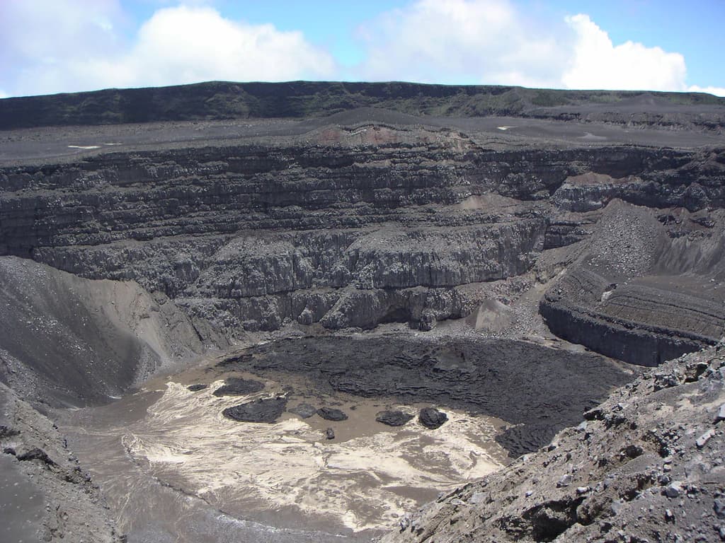
Karthala National Park landscape and geographic character
The landscape of Karthala National Park is defined by the dramatic volcanic landforms of Mount Karthala, an active shield volcano forming the southern portion of Grande Comore island. The mountain rises from sea level to 2,361 meters at its summit, creating a sloping volcanic mass with the characteristic gentle profiles typical of shield volcanoes. A prominent caldera measuring approximately 3 kilometers by 4 kilometers occupies the summit region, the result of repeated volcanic activity that has collapsed and reshaped the crater over centuries. The terrain within the park encompasses steep upper slopes, exposed volcanic rock within the caldera, and the dense forest cover that characterizes the mid-elevation zones. The landscape transitions from agricultural zones at lower elevations through the forested mid-slopes to heathland and bare volcanic rock near the summit.
Karthala National Park ecosystems, habitats, and plant life
The ecological character of Karthala National Park is shaped by the mountain's elevation gradient and isolated island position in the Mozambique Channel. Below approximately 1,200 meters, the mountain transitions from human-modified landscapes to intact moist evergreen forest that extends to about 1,800 meters elevation. This cloud forest zone supports dense vegetation adapted to the persistent moisture from the mountain's interaction with oceanic weather patterns. Above the forest line, the vegetation transitions to stunted trees and heathland where the giant heather Erica comorensis forms a distinctive component of the summit-zone flora. The isolation of the Comoros archipelago has driven significant evolutionary divergence, resulting in numerous species found only on these islands. The forest ecosystem faces threats from logging and agricultural expansion that encroach upon the park's boundaries.
Karthala National Park wildlife and species highlights
Karthala National Park is significant for its unique avifauna, with four bird species endemic to Mount Karthala's slopes. These include the Grand Comoro drongo, Humblot's flycatcher, Karthala scops owl, and Karthala white-eye, each occupying specific habitat zones within the mountain's forests and heathlands. The broader Important Bird Area designated by BirdLife International encompasses 14,228 hectares and supports additional restricted-range species including the Comoros blue pigeon, Comoros olive pigeon, Grand Comoro bulbul, and Humblot's sunbird. The mountain also supports populations of Comoros thrushes, Grand Comoro brush warblers, and Malagasy harriers. The forest and heathland habitats provide feeding and nesting grounds for these species, though the isolated nature of the ecosystem makes the avifauna particularly vulnerable to environmental changes.
Karthala National Park conservation status and protection priorities
Karthala National Park serves as a critical conservation area for Comoros, protecting the nation's highest elevation terrain and its associated endemic species. The park's Ramsar designation in 2006 acknowledged the international significance of the wetland areas within the volcano's summit region. The Important Bird Area status awarded to the upper slopes reflects the global importance of protecting populations of restricted-range species that occur nowhere else. The Comoros National Parks Authority administers the protected area, working to preserve the unique combination of volcanic landscape, forest ecosystems, and endemic biodiversity. Conservation challenges include the threat of logging and agricultural expansion that pressures the forest boundaries, as well as the inherent risks associated with protecting an active volcanic area.
Karthala National Park cultural meaning and human context
Mount Karthala holds cultural significance for the people of Grande Comore, with the Arabic name Al Qirṭālah reflecting the mountain's place in local toponymy. The volcano's prominent position relative to Moroni, the capital located on the island's western coast, means the mountain forms a visible backdrop to daily life for many Comorians. The periodic volcanic activity, including the evacuations required during the 2005 and 2006 eruptions, demonstrates the ongoing relationship between the local population and this natural phenomenon. The mountain's forest resources and water catchment functions also hold traditional importance for surrounding communities, though the formal protected area status now guides management of these resources.
Top sights and standout views in Karthala National Park
Karthala National Park offers access to the highest point in Comoros, where visitors can explore the volcanic landscapes of an active shield volcano with a dramatic summit caldera. The endemic birdlife represents one of the park's most remarkable features, with four species found nowhere else on Earth. The moist evergreen forest zone between 1,200 and 1,800 meters provides a distinctive ecological experience, transitioning to unique heathland environments near the summit where giant heather creates unusual vegetation patterns. The park's Ramsar wetland designation acknowledges the ecological importance of the highland water systems, even as volcanic activity continues to reshape the summit environment.
Best time to visit Karthala National Park
The best time to explore Karthala National Park corresponds to the dry season in Comoros, typically spanning from May through October. During these months, precipitation is reduced and visibility improves, allowing for clearer views from the summit across the archipelago. The dry season also makes hiking conditions more favorable, with less muddy terrain on the forest trails. However, visitors should be aware that the mountain's weather can change rapidly due to its elevation and exposure, with cloud cover and brief showers possible even during generally dry periods. The volcano's active status means that any visit should incorporate current safety guidance from local authorities regarding volcanic activity levels.