Mori Atlas logo
National parkKirthar National Park

Discover the mapped boundaries and arid terrain of Kirthar National Park, a key protected area in southern Pakistan.

Kirthar National Park: Pakistan's Iconic Protected Mountain Landscape and Wildlife Refuge

Kirthar National Park stands as a monumental protected landscape in Pakistan, safeguarding over 3,000 square kilometers of the Kirthar Mountains' semi-arid terrain. Established as one of the country's earliest national parks, it provides a vital refuge for specialized wildlife, including the endemic Sindh ibex and elusive Indian leopards. Its rugged ridges and deep valleys offer a unique atlas perspective on a fragile desert ecosystem where natural habitats are increasingly scarce.

mountain protected areaSindh wildlifedesert ecosystemIUCN Category IIImportant Bird AreaKirthar Mountains

Kirthar National Park

National park

Park overview

Structured park overview, official facts, and landscape profile for Kirthar National Park

Kirthar National Park park facts, protected area profile, and essential visitor context

Review the core facts for Kirthar National Park, including designation, size, terrain, visitor scale, habitats, and operating context in one park-focused overview.

About Kirthar National Park

Kirthar National Park encompasses a remarkable diversity of terrain within its boundaries, from steep rocky ridges and cliffs to narrow valleys and seasonal watercourses. The Kirthar Mountains rise dramatically from the surrounding plains, creating microclimates and ecological niches that support species more typical of much higher elevations or wetter regions. The park's significance extends beyond its borders as a corridor for wildlife movement between increasingly fragmented habitats across southern Pakistan. Its remote location and challenging terrain have historically limited human settlement within the park boundaries, though pastoral communities have traditionally used the area for seasonal grazing. The park's size and ecological diversity make it one of the most important protected areas in Sindh, providing crucial habitat for species that have lost ground throughout their ranges elsewhere in the Indian subcontinent.

Quick facts and research context for Kirthar National Park

Kirthar National Park lies in the Kirthar Mountains, a range that forms a natural barrier between the Sindhi plains and the Balochistan plateau. The park is managed by the Sindh Wildlife Department and holds IUCN Category II protection status. Its landscape features rocky ridges, narrow valleys, and sparse vegetation adapted to arid conditions. The park achieved Important Bird and Biodiversity Area designation in 2004 alongside the neighboring Hub Dam, recognizing its significance for avian species. It was the second national park established in Pakistan after Lal Suhanra.

Protection and recognition

Tracing the terrestrial boundaries and official conservation history of the park since 1972.

Documented Protection Status and Legal Designation of Kirthar National Park

Discover the official designation records, terrestrial conservation scope, and historical protection framework established for Kirthar National Park. Reviewing structured historical records helps researchers and conservationists trace the evolution of regional park systems and verify key land-management boundaries.

Protection details

Protection scope
Terrestrial
Designated year
1972
Transboundary protection
No
Park context

Deeper park guide and search-rich context for Kirthar National Park

Kirthar National Park history, landscape, wildlife, and travel context

Explore Kirthar National Park through its history, landscape character, ecosystems, wildlife, conservation priorities, cultural context, and seasonal travel timing in a structured park guide built for atlas discovery and search intent.

Why Kirthar National Park stands out

Kirthar National Park is best known for its population of Sindh ibex, a distinctive wild goat subspecies found only in this region, and for its population of Indian leopards, which persist in this mountainous desert environment despite severe habitat fragmentation across the subcontinent. The park also supports significant herds of urial (a wild sheep species) and chinkara gazelles, along with a remarkable diversity of raptors including bearded vulture, various eagle species, and multiple vulture species that migrate through or reside in the area.

Kirthar National Park history and protected-area timeline

Kirthar National Park traces its formal protection history to 1972 when the area was first designated as a wildlife sanctuary. Two years later, on January 31, 1974, it received national park status, becoming only the second such protected area in Pakistan after Lal Suhanra National Park in Punjab. This early establishment placed Pakistan among the first South Asian nations to develop a formal national park system. The park's designation reflected growing recognition in the 1970s of the need to protect representative samples of Pakistan's diverse ecosystems, particularly those harboring significant wildlife populations. The subsequent designation of the park and adjacent Hub Dam area as an Important Bird and Biodiversity Area in 2004 further reinforced its conservation significance at an international level.

Kirthar National Park landscape and geographic character

The Kirthar Mountains form the backbone of this protected area, comprising a series of parallel ridges and valleys that extend in a roughly northwest-southeast direction. The terrain is characterized by steep-sided valleys, rocky outcrops, and exposed cliff faces that provide habitat for cliff-dwelling species. Elevation within the park ranges from around 300 meters in the valley floors to over 1,500 meters at higher peaks, creating varied microclimates across the gradient. The area receives limited rainfall, making it a semi-arid environment where water availability strongly influences vegetation patterns and wildlife distribution. Seasonal streams and natural springs provide critical water sources during dry periods, and the geology includes formations that help retain groundwater.

Kirthar National Park ecosystems, habitats, and plant life

The vegetation of Kirthar National Park reflects its arid to semi-arid climate, dominated by sparse grasslands and drought-resistant shrub species. Grasses such as Cymbopogon, Pennisetum, and Panicum occur in patches, particularly in areas with better soil moisture. Woody vegetation includes Prosopis cineraria, various acacia species, and Salvadora oleoides, with Tamarix found near water sources. The plant community supports a diverse arthropod fauna and provides browse for herbivores. The park's position at the interface of multiple ecological zones, from the Sindhi plains into the Balochistan highlands, gives it a transitional character that contributes to its biodiversity value.

Kirthar National Park wildlife and species highlights

Kirthar National Park supports an impressive array of wildlife despite its harsh environment. The mammal fauna includes 38 documented species, headlined by the Indian leopard, a predator that persists here at the edge of its range in surprisingly good numbers. The Sindh ibex, a subspecies of wild goat endemic to this region, remains the park's most iconic resident, inhabiting the rocky cliffs and ridges. Urial populations thrive on the steeper slopes, while chinkara gazelles occupy valley floors and more open terrain. Striped hyenas, Indian wolves, and caracals represent the diverse carnivore community, supported by smaller predators including various mongoose species and the honey badger. The bird fauna is particularly noteworthy with over 165 species recorded, including significant populations of vultures and eagles. The reintroduction project for blackbuck represents an important conservation effort for this species that has been extirpated from much of its former range.

Kirthar National Park conservation status and protection priorities

As one of Pakistan's oldest and largest national parks, Kirthar represents a critical conservation asset in a region where natural habitats have been extensively modified. The park provides essential refuge for species that have declined across their ranges, particularly the Sindh ibex and Indian leopard, both of which face significant threats outside protected areas. Its Important Bird and Biodiversity Area designation recognizes the site's significance for raptors and migratory birds, including several vulture species that have suffered catastrophic population declines across South Asia. The blackbuck reintroduction project demonstrates active management for species recovery. However, the park faces ongoing challenges from grazing pressure, fuel wood collection, and the broader issue of habitat connectivity in a densely populated region.

Top sights and standout views in Kirthar National Park

The mountain landscapes of Kirthar, with their dramatic ridges and deep valleys, offer a distinctive visual character unlike the more famous Himalayan parks of Pakistan. The sight of Sindh ibex navigating impossibly steep cliff faces represents one of the region's most remarkable wildlife viewing opportunities. The diversity of raptors, particularly during winter months when vultures and eagles are more active, makes Kirthar significant for bird enthusiasts. The park's size and relative remoteness provide a wilderness experience increasingly rare in the populated Indus plains.

Best time to visit Kirthar National Park

The optimal period for visiting Kirthar National Park spans from October through March when temperatures are moderate and wildlife activity is highest. Summer months from May to September bring extreme heat that limits both visitor activity and wildlife sightings, as animals become more nocturnal and seek shade during daylight hours. The winter season brings cooler temperatures ideal for hiking and wildlife observation, though some higher-elevation areas may experience cold nights. The monsoon season from July to September can bring brief but intense rainfall that may affect access to certain areas of the park.
Monthly climate preview

Track monthly temperature ranges and precipitation averages across the protected landscape

Kirthar National Park Climate Normals, Long-Term Temperature and Precipitation Rhythm

Representative coordinates record long-term monthly temperature and precipitation averages for Kirthar National Park between 1991 and 2020. Examining the complete twelve-month profile reveals detailed patterns across the protected terrain.
Annual mean26 °C
17 °C32 °C
Jan17°
Feb19°
Mar24°
Apr29°
May31°
Jun32°
Jul31°
Aug29°
Sep29°
Oct27°
Nov23°
Dec18°
Warmest month
June

31.8 °C

Coolest month
January

16.6 °C

Wettest month
August

1.6 mm/day

Driest month
November

0 mm/day

Park location guide

Geography guide, regional context, and park location map for Kirthar National Park

Kirthar National Park park geography, regions, and map view in Pakistan

Understand where Kirthar National Park sits in Pakistan through a broader geographic reading of the surrounding landscape, nearby location context, and its mapped position within the national park landscape.

How Kirthar National Park fits into Pakistan

Pakistan, officially the Islamic Republic of Pakistan, is a federal parliamentary Islamic republic in South Asia. It is the fifth-most populous country and the 33rd-largest by area. The country gained independence from British India in 1947 and has a diverse history spanning ancient civilizations including Mehrgarh and the Indus Valley Civilisation. Pakistan shares maritime borders with Oman and is bounded by the Arabian Sea, Gulf of Oman, and several neighboring countries.

Wider geography shaping Kirthar National Park in Pakistan

Pakistan is located in South Asia, bordered by the Arabian Sea to the south, the Gulf of Oman to the southwest, and shares land borders with India to the east, Afghanistan to the west, Iran to the southwest, and China to the northeast. The country also shares a maritime border with Oman in the Gulf of Oman. The Wakhan Corridor in Afghanistan separates Pakistan from Tajikistan in the northwest.

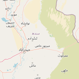
Map view of Kirthar National Park

Use this park location map to pinpoint Kirthar National Park in Pakistan, understand its exact geographic position, and read its mapped placement within the surrounding landscape more clearly.

Pigeon | © OpenStreetMap contributors

Location context for Kirthar National Park

Sindh
Park atlas

Map the Regional Geography and Diverse Protected Landscapes Around Kirthar National Park

Discover More Protected Areas: Explore National Parks Near Kirthar National Park and its Surrounding Arid Wilderness

Explore national parks and protected areas near Kirthar National Park, tracing the arid wilderness, mountain terrain, and conservation landscapes of the broader Sindh province. Compare these regional protected areas to gain geographical context, understand their ecological connections, and deepen your atlas-style discovery of Pakistan's natural heritage.
Nature reserveSindh
About 80 km away#1 closest

Northeast

Pai Forest Nature Reserve: Geography and Protected Landscape Context in Sindh

An Indus floodplain reserve featuring arid and riverine flora

Pai Forest in Sindh offers a distinctive study of protected landscapes where canal irrigation sustains both riverine and arid plant communities. This reserve functions as a vital ecological island amidst agricultural plains, providing a rich case for exploring the interaction between water management and natural terrain within the Indus valley geography.

Relief
Lowland
Climate
Arid
Scope
Terrestrial
Water
Major water bodies
Wildlife reserveSindh
About 95 km away#2 closest

Southeast

Keenjhar Lake Wildlife Reserve: Sindh Province Protected Wetland and Geographic Atlas

Mapped freshwater wetland and regional wildlife sanctuary

Keenjhar Lake is a prominent freshwater wetland and wildlife reserve in the Thatta District of Sindh. This expansive basin serves as a key ecological anchor for migratory waterbirds and a central feature of the regional landscape. The area combines significant hydrological value with distinct cultural history, providing a unique look into the protected geography of southeastern Pakistan.

Area
134.68 km²
Relief
Lowland
Scope
Terrestrial
Water
Water-dominated
Protected areaThatta District
About 101 km away#3 closest

South

Haleji Lake Protected Area: Mapping Wetlands and Freshwater Ecosystems in Thatta District

A significant freshwater reservoir and Ramsar site in southern Sindh, Pakistan.

Situated in the low-lying plains of Thatta District, Haleji Lake functions as an essential freshwater sanctuary for migratory bird species. The site features a distinct mosaic of managed reservoirs, fringing marshes, and brackish lagoons, offering a unique look at the interaction between water engineering and natural wetland conservation in the Indus basin.

Area
6.58 km²
Established
1943
Relief
Lowland
Scope
Terrestrial
Marine protected areaBalochistan
About 133 km away#4 closest

Southwest

Churna Island Marine Protected Area: Geography and Coastal Atlas of Balochistan

Mapping the coral reef systems and rocky island terrain

Churna Island represents a unique marine protected area located near the border of Balochistan and Sindh. Characterized by a desolate rocky surface, the true ecological value resides in its extensive submerged reef structures, which provide habitat for a vast array of coral species and pelagic fish. This atlas resource provides a structured look at the island's coastal geography and its growing role in regional marine conservation.

Area
0.6 km²
Established
2024
Relief
Upland
Climate
Subtropical
Protected areaBalochistan
About 140 km away#5 closest

West

Miani Hor Protected Area: Coastal Lagoon Mapping and Regional Geography in Balochistan

Coastal lagoon and unique mangrove wetland ecosystem

Miani Hor functions as a major tidal lagoon and protected wetland along the Balochistan coast. The area is defined by its extensive mangrove forests and connection to the Arabian Sea, providing a essential study in estuarine geography and wetland conservation within the Lasbela District.

Area
74.71 km²
Established
2001
Relief
Lowland
Scope
Mixed
Wildlife reserveSindh
About 146 km away#6 closest

Northeast

Deh Akro-II Desert Wetland Complex: Protected Landscape and Geographic Mapping

Inland wetland and desert sanctuary in Sindh, Pakistan

Explore the distinctive geography of Deh Akro-II Desert Wetland Complex, a protected wildlife reserve defined by its unusual combination of sand dunes and freshwater lakes. This atlas entry details the natural terrain and ecological boundaries of one of Pakistan's most significant inland wetland systems, illustrating the complex intersection of arid and aquatic habitats within the Indus River system.

Area
205 km²
Established
1988
Relief
Lowland
Climate
Arid
National parkBalochistan
About 160 km away#7 closest

West

Hingol National Park: Pakistan's Unique Protected Landscape and Geological Atlas

Discover dramatic rock formations and coastal geography.

Hingol National Park stands as a monumental protected landscape within Balochistan, Pakistan, offering an unparalleled atlas view of geological diversity. Renowned for its hoodoos like the Princess of Hope and the Balochistan Sphinx, the park also features active mud volcanoes and striking coastal semi-desert terrain. The confluence of the Hingol River with the Arabian Sea creates important wetland habitats. This national park provides a rich context for exploring unique natural formations and regional geography, making it a significant point of discovery within Pakistan's protected areas.

Area
6,100 km²
Established
1988
IUCN
II
Relief
Mixed relief
Wildlife reserveSindh
About 187 km away#8 closest

Southeast

Jubho Lagoon Wildlife Reserve: Coastal Wetland Geography and Regional Map Context

Mapping brackish lagoons and migratory bird habitats in Sindh

Investigate the protected landscape of Jubho Lagoon, a shallow brackish wetland in southern Sindh. The area features a complex mosaic of tidal inlets, exposed mudflats, and freshwater-influenced marshes that serve as a primary regional habitat for migratory flamingos and pelicans.

Area
7.06 km²
Established
2001
Relief
Lowland
Scope
Terrestrial

Common questions about visiting, size, designation, and location context for Kirthar National Park

Kirthar National Park FAQs for park facts, access, geography, and protected area context

Find quick answers about Kirthar National Park, including protected-area facts, park geography, trail and visitor context, and how the park fits into its surrounding country and regional landscape.
MoriAtlas Explorer

Continue Your Protected Areas Search Across the Global Atlas

Deepen your exploration by continuing the structured search for national parks and protected areas worldwide. Utilize the comprehensive filtering capabilities to compare different conservation landscapes and refine your understanding of global park geography. Discover more about the distribution and characteristics of protected natural areas.

Global natural geography