
Why Lam Nam Kok National Park stands out
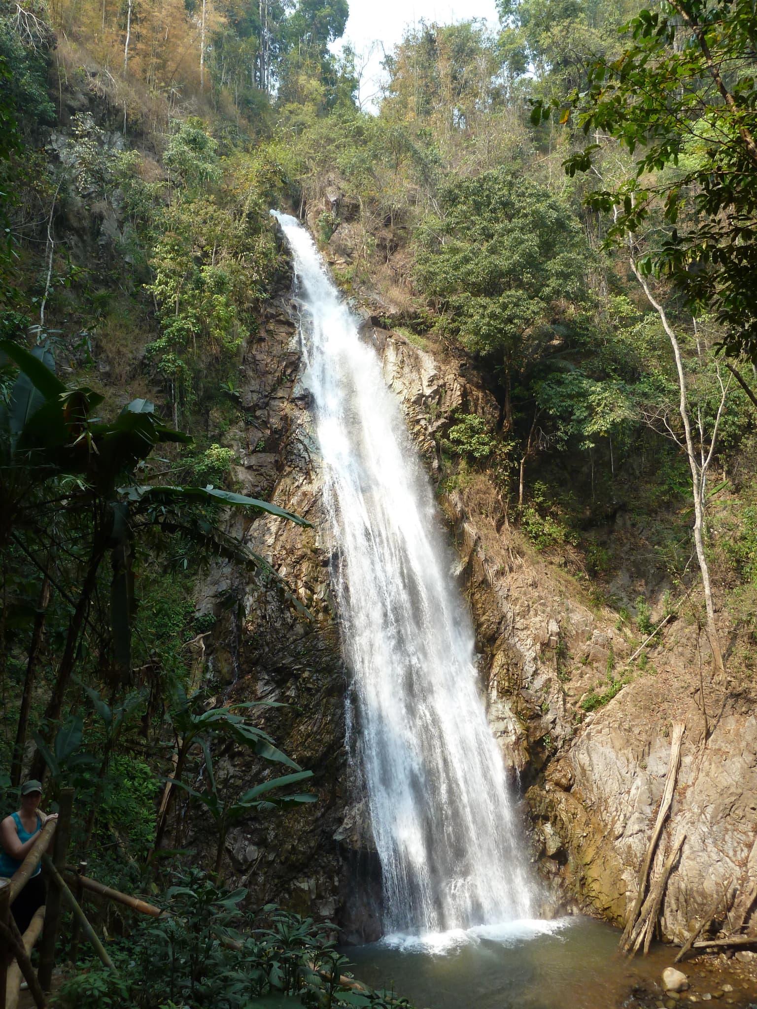
Lam Nam Kok National Park is best known for its scenic mountain and river landscapes in Thailand's far north. The Kok River corridor provides the park's central geographic feature, with river cruises and rafting being popular visitor activities. The park contains several notable waterfalls including Huai Kaeo, a three-tier cascade with the highest tier dropping 40 meters, and Khunkorn Waterfall. A distinctive cultural landmark within the park is Wat Phuttha Utthayan Doi Insi, a Buddhist monastery featuring a 15.1-meter white Buddha image in meditation posture. The park also offers hot spring facilities at Phasoet, located about 20 kilometers from Chiang Rai city.

Lam Nam Kok National Park history and protected-area timeline
Lam Nam Kok National Park was established on May 10, 2002, making it one of Thailand's more recently designated national parks. The creation of the park reflected Thailand's ongoing efforts to protect remaining areas of natural forest in the northern provinces. The park was carved from existing forest lands in Chiang Rai province to safeguard the Kok River corridor and surrounding mountain ecosystems. The establishment followed standard procedures for Thai national park designation, with the Department of National Parks, Wildlife and Plant Conservation assuming management authority. The park's formation coincided with broader conservation initiatives in Thailand's northern region during the early 2000s period. Since its designation, the park has operated as a Category II protected area under International Union for Conservation of Nature guidelines, reflecting its national park classification.
Lam Nam Kok National Park landscape and geographic character
The landscape of Lam Nam Kok National Park consists of mountainous terrain typical of Thailand's northern highlands. The Kok River valley provides the most prominent topographic feature, with the river cutting through the park's interior and creating scenic corridors along its banks. The surrounding hills and ridges rise from the valley floors, covered in dense forest that transitions with elevation. The park's elevation range supports diverse vegetation zones, from lower valley forests to higher mountain forest coverage. Waterfalls punctuate the landscape at various points, with Huai Kaeo Waterfall being particularly notable for its three-tier structure reaching heights of 20, 30, and 40 meters respectively. The terrain creates natural overlooks and viewpoints throughout the park, with the combination of forest cover, river courses, and waterfall features providing visual variety.
Lam Nam Kok National Park ecosystems, habitats, and plant life
The ecosystems within Lam Nam Kok National Park reflect the northern Thailand montane forest environment. The park's forest cover includes mixed deciduous and evergreen species appropriate to the elevation and climate zone. The Kok River and its tributaries support aquatic ecosystems and provide water resources for the surrounding vegetation. The protected status of the area helps maintain ecological processes in a region where agricultural expansion and development pressures exist. The mountain forests serve as watershed areas, regulating water flow and protecting soil integrity in the catchment basins. Wildlife populations persist in the forest habitats, though specific species documentation in the source material is limited to general park descriptions rather than detailed species inventories.
Lam Nam Kok National Park wildlife and species highlights
While detailed species inventories are not extensively documented in the available source material, Lam Nam Kok National Park's forest and river habitats support wildlife populations typical of northern Thailand's protected areas. The mountain forest environments provide shelter for various terrestrial species, while the Kok River corridor offers aquatic habitat. The protected area designation helps preserve connectivity for wildlife movement through the northern highlands. Visitor activities such as river cruises and nature observation provide opportunities for wildlife viewing, though specific notable species would require more detailed ecological surveys than presented in the source material. The park's location in Chiang Rai province places it within a region known for biodiversity in Thailand's northern mountain zone.
Lam Nam Kok National Park conservation status and protection priorities
Lam Nam Kok National Park functions as a Category II protected area under the IUCN protected area classification system, representing national park designation. The park protects forest ecosystems and watershed areas in a province where agricultural development has reduced natural forest cover in surrounding regions. The Kok River corridor protection helps maintain water quality and ecological function for downstream areas, including the Mekong River confluence at Chiang Saen. The national park status provides regulatory framework for managing visitor access, resource extraction, and development activities within the protected boundaries. Thailand's Department of National Parks, Wildlife and Plant Conservation maintains oversight of conservation management and visitor services for the park.
Lam Nam Kok National Park cultural meaning and human context
Lam Nam Kok National Park contains cultural attractions that complement its natural features. Wat Phuttha Utthayan Doi Insi represents a Buddhist monastery presence within the park, where monks practice forest meditation under an arrangement with the Department of National Parks. The monastery features a 15.1-meter white Buddha image in meditation posture alongside a 10-meter cetiya or pagoda, creating a spiritual landmark within the protected landscape. This arrangement reflects a specific Thai approach to integrating religious practice with conservation, where monastic presence supports forest protection responsibilities. The Kok River itself holds cultural significance as a traditional waterway connecting communities along its course from Myanmar through northern Thailand to the Mekong.
Top sights and standout views in Lam Nam Kok National Park
The most prominent highlights of Lam Nam Kok National Park include the three-tier Huai Kaeo Waterfall, with its highest cascade reaching 40 meters and bamboo bridge allowing visitor access. The Kok River offers river cruise and rafting experiences along its 130-kilometer course through the region. Wat Phuttha Utthayan Doi Insi provides a distinctive cultural attraction with its large white Buddha image and monastic community practicing forest dharma. Phasoet Hot Springs offer visitor relaxation facilities with bathing options and massage services approximately 20 kilometers from Chiang Rai city. Khunkorn Waterfall adds additional waterfall viewing opportunities within the park's attractions portfolio.
Best time to visit Lam Nam Kok National Park
The optimal time to visit Lam Nam Kok National Park corresponds to Thailand's cool dry season from November through February, when temperatures are moderate and rainfall is minimal. This period offers the most comfortable conditions for outdoor activities including waterfall viewing, river cruises, and forest exploration. The wet season from May through October brings monsoon rains that can affect trail conditions and visibility, though the waterfalls typically flow with greater volume during and immediately after rainy periods. The hot season from March through May brings higher temperatures that may make extensive outdoor activity less comfortable. Visitors interested in hot spring experiences may find the cool season particularly pleasant for bathing. The park's waterfall features maintain water flow throughout the year according to source documentation.