

Why Lane Cove National Park stands out
Lane Cove National Park is best known for its remarkable position as an urban national park that preserves native bushland within a densely populated metropolitan area. The park is renowned for its diverse vegetation communities that transition from wet sclerophyll forest in the gullies to dry sclerophyll woodland on the ridges, with heathland on exposed sandstone ridges and mangroves along the tidal reaches. The Lane Cove River, which runs through the heart of the park, provides a natural corridor for wildlife and recreational opportunities including kayaking and fishing. The park is also notable for the Great North Walk trail that follows the riverbank, connecting Sydney's CBD to Newcastle.
Lane Cove National Park history and protected-area timeline
Lane Cove National Park has a layered history of protection and development. The central section of the park between De Burghs Bridge and Fullers Bridge was set aside as a park in the 1920s and subsequently developed with picnic areas along the river banks. In the 1930s, a weir was constructed near Fullers Bridge, converting the middle section of the river from tidal saltwater to freshwater with a constant water level suitable for recreational use in rowing boats and canoes. This area was managed by a trust under the name Lane Cove River Park. The Government of New South Wales took over direct control in 1982, renaming the area Lane Cove Regional Park. Various adjacent areas of undeveloped government land were incorporated over time, including land around Pennant Hills Park. The park was officially redesignated as Lane Cove National Park in 1992. A significant bushfire in 1994 prompted the formation of the Friends of Lane Cove National Park, a volunteer organization that continues to coordinate bushcare groups and source funding for regeneration works.
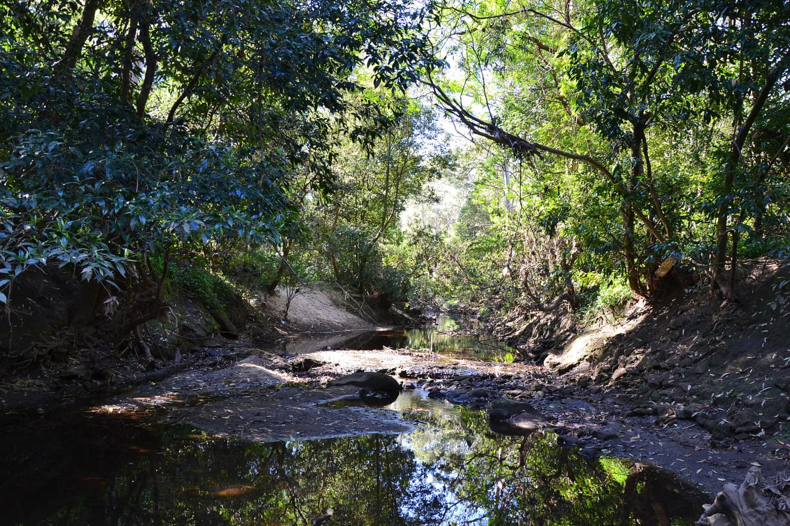
Lane Cove National Park landscape and geographic character
The landscape of Lane Cove National Park is defined by the Lane Cove River valley, which carves through the Sydney sandstone terrain. The park encompasses rugged terrain on the slopes of the river valley, with elevation changes creating diverse microenvironments. The vegetation follows this topographic gradient, with moist gullies supporting wet sclerophyll forest characterized by tall eucalypts and dense understorey, while ridgelines and exposed areas support drier sclerophyll woodland and heathland. The river itself transitions from tidal saltwater in its lower reaches to freshwater above the weir at Fullers Bridge, with mangroves and tidal flats occurring where saltwater intrudes. The park's width is generally less than a kilometre except in the upper northwestern region, giving it a long, linear character that follows the river corridor. Despite its small size and complete suburban envelopment, the park retains a sense of naturalness due to the density of its vegetation cover.
Lane Cove National Park ecosystems, habitats, and plant life
Lane Cove National Park supports a surprising diversity of vegetation communities given its suburban setting. The wet sclerophyll forest occurs in the more sheltered gullies and drainage lines, characterized by trees such as Sydney blue gum and grey gum with a dense understorey of ferns and shrubs. The dry sclerophyll forest on the ridges features ironbark and stringybark eucalypts with a more open understorey. Heathland communities occupy exposed sandstone areas with shallow soils, supporting characteristic species such as grass-trees, banksias, and flannel flowers. The tidal sections of the river support mangrove forests and tidal flats, which serve as important nursery areas for fish and crustaceans. This mosaic of habitats within a compact area contributes to the park's ecological significance within the Sydney region.
Lane Cove National Park wildlife and species highlights
The park is home to a variety of native bird species that thrive in the varied habitats. Common bird observations include brushturkeys, kookaburras, superb fairywrens, crimson rosellas, sulphur-crested cockatoos, rainbow lorikeets, and eastern whipbirds. The park also supports populations of introduced bird species including common mynas and red-whiskered bulbuls. Reptile species commonly found in the park include eastern water dragons and lace monitors. Mammals present include swamp wallabies and echidnas, with the river providing habitat for various fish species including Australian bass, which benefit from the fish ladder that allows them to access freshwater breeding grounds upstream of the weir.
Lane Cove National Park conservation status and protection priorities
Lane Cove National Park represents an important conservation asset within the Sydney metropolitan area, preserving native bushland and river ecosystems in a region where development pressure is intense. The park protects representative examples of Sydney's native vegetation communities, including wet and dry sclerophyll forests, heathland, and mangroves. Its position along the Lane Cove River provides protection for water quality and aquatic habitats, while the river corridor serves as a wildlife movement pathway through the urban landscape. The park faces ongoing challenges from its urban setting, including weed infestations in some areas such as Fiddens Wharf and Fairyland, and the visual and noise intrusion of nearby infrastructure such as the M2 Hills Motorway. Conservation efforts are supported by the Friends of Lane Cove National Park, which coordinates volunteer bushcare activities and seeks funding for regeneration works.
Lane Cove National Park cultural meaning and human context
The Lane Cove River area has been inhabited by Aboriginal people for thousands of years, though the specific indigenous heritage of the park area is not extensively documented in the available sources. The park's name derives from the suburb of Lane Cove, which itself was named after the river. The landscape contains evidence of historical European use, including old logging trails that now form parts of the walking track network. The Great North Walk, which traverses the park, follows traditional pathways and connects Sydney to Newcastle, creating a modern heritage link through the landscape.
Top sights and standout views in Lane Cove National Park
Lane Cove National Park offers visitors a unique combination of accessible nature within a major city. The river-based recreation opportunities, including kayaking and rowing in the freshwater section above the weir, distinguish this park from many other Sydney reserves. The Great North Walk provides long-distance walking opportunities through attractive river valley scenery. The diversity of vegetation communities, from mangroves to heathland to wet forest, supports varied wildlife viewing opportunities within a compact area. The contrast between the natural bushland and the surrounding suburban development creates a striking metropolitan wilderness experience.
Best time to visit Lane Cove National Park
Lane Cove National Park can be visited throughout the year, with each season offering different experiences. The warmer months from spring through autumn are ideal for walking, cycling, and river-based activities, while the mild Sydney winter provides comfortable conditions for bushwalking. Spring brings wildflower displays in the heathland areas, and the cooler months offer good opportunities for birdwatching as birds are more active in the early morning. The park is accessible year-round, though summer heat should be considered when planning activities.