
Why Makalu Barun National Park stands out
Makalu Barun National Park is best known for its unparalleled vertical extent, protecting the complete ecological spectrum from tropical dipterocarp forests at low elevations through subtropical, temperate, subalpine, and alpine zones to perpetual snow and ice. The park encompasses Makalu, the fifth-highest mountain in the world, and contains exceptional biodiversity including 3,128 flowering plant species, 440 bird species, and 88 mammal species. The red panda, snow leopard, and clouded leopard inhabit its diverse habitats, while the Barun Valley represents one of the last pristine wilderness areas in the Eastern Himalayas. The park's unique combination of extreme altitude range, ecological diversity, and intact ecosystems makes it a globally significant conservation area.
Makalu Barun National Park history and protected-area timeline
The establishment of Makalu Barun National Park emerged from scientific surveys conducted in the Barun Valley during the 1980s by personnel of The Mountain Institute under president Daniel C. Taylor. Initially investigating the possibility of finding evidence for the Yeti legend, the surveys instead revealed the valley's extraordinary biological richness, which prompted interest in creating a new protected area. A formal proposal was formulated in 1985, leading to the initiation of the Makalu-Barun Conservation Area Project (MBNCPA) in 1988 as a joint endeavor between Nepal's Department of National Parks and Wildlife Conservation and The Mountain Institute. The conservation area was officially gazetted in 1991, at which time approximately 32,000 people resided within its boundaries across 12 Village Development Committees. An innovative community-based conservation approach was implemented, emphasizing biodiversity management with local communities and creating Community Forest User Groups with legal rights to sustainably manage designated forested areas. In 1999, the conservation area was converted into a buffer zone under the Buffer Zone Management Guidelines, which prioritized conservation of forests, wildlife, and cultural resources. The inaccessible Barun River valleys, containing some of the last remaining pristine forests and alpine meadows, were designated as Nepal's first Strict Nature Reserve to protect natural ecosystems in an undisturbed state for scientific study and environmental monitoring.
Makalu Barun National Park landscape and geographic character
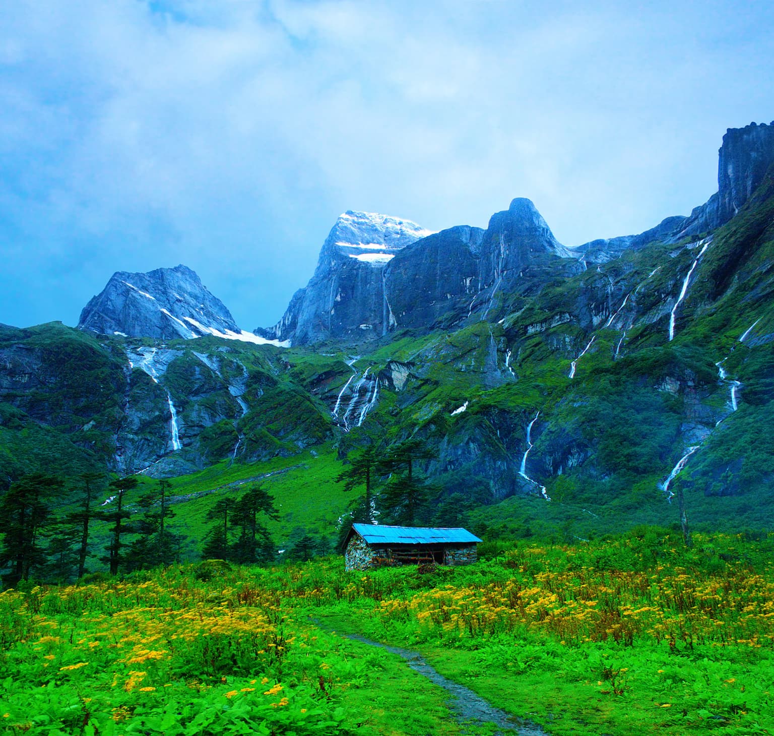
The landscape of Makalu Barun National Park is defined by extreme topographical variation, with elevations ranging from approximately 344 meters in the Arun River valley to 8,463 meters at the summit of Makalu. The terrain is characterized by dramatic glacial valleys, steep granite walls, and towering Himalayan peaks. The Barun River has carved a deep valley system that descends from the high mountains through progressively lower elevations, creating a continuous ecological gradient. The southeastern portion of the park features the lower Arun valley with its relatively gentle terrain, while the central and northern areas are dominated by the massive, glaciated peaks of the Makalu-Chamlang-Baruntse massif. The park's eastern extension into the Arun valley represents one of the mostremote and least-developed areas in Nepal, with the international border with Tibet running along the northern boundary. The landscape transitions through distinct ecological zones, from the subtropical forests of the lower valleys through temperate oak-laurel forests, subalpine conifer stands, alpine meadows, and finally to the permanent snow and ice of the high peaks.
Makalu Barun National Park ecosystems, habitats, and plant life
The ecological diversity of Makalu Barun National Park is extraordinary, encompassing five distinct bioclimatic zones within its boundaries. Below 1,000 meters, tropical dipterocarp monsoon forest dominates, featuring stands of sal, while the subtropical zone between 1,000 and 2,000 meters contains Schima and Castanopsis forest communities. The temperate zone from 2,000 to 3,000 meters supports predominantly broadleaf evergreen species of the oak and laurel families, alongside deciduous stands of maple and magnolia. Above 3,000 meters, subalpine conifer forests of Himalayan birch and East Himalayan fir extend to approximately 4,000 meters, transitioning into alpine pastures characterized by dwarf rhododendron, juniper, aromatic herbs, and wildflowers. The region above 5,000 meters comprises primarily rock and ice with minimal vegetation. Botanists have recorded 3,128 species of flowering plants in the park, including 25 of Nepal's 30 rhododendron varieties, 48 primrose species, 47 orchids, and 19 bamboo species, making this one of the most botanically rich areas in the Himalayas.
Makalu Barun National Park wildlife and species highlights
Makalu Barun National Park supports remarkable faunal diversity across its diverse habitats. The park is home to 88 mammal species, including several endangered and rare species. The snow leopard and clouded leopard represent the apex predators, while the red panda inhabits the bamboo-rich forests of the middle elevations. Other notable mammals include the Indian leopard, Himalayan wolf, Asian black bear, Himalayan tahr, Himalayan goral, musk deer, and barking deer. The avian fauna is equally impressive, with ornithologists recording 440 bird species ranging from eagles and other raptors to white-necked storks and brilliantly colored sunbirds. Sixteen rare or protected bird species occur in the park, including the rose-ringed parakeet, Blyth's kingfisher, blue-naped pitta, and spiny babbler. The park also supports 315 butterfly species, 43 reptile species, 16 amphibian species, and 78 fish species in its ponds, lakes, and rivers. The first camera trap image of an Asian golden cat in Nepal was obtained in the park at an altitude of 2,517 meters in May 2009, highlighting the ongoing discovery of rare species in this relatively unexplored area.
Makalu Barun National Park conservation status and protection priorities
Makalu Barun National Park holds exceptional conservation significance as the world's only protected area encompassing an elevation gradient of more than 8,000 meters, protecting the complete ecological spectrum from tropical forest to alpine summit. The park is part of the Sacred Himalayan Landscape, a transboundary conservation initiative spanning the borders of Nepal, India, Bhutan, and China. The Barun Valley was designated as Nepal's first Strict Nature Reserve, protecting some of the last remaining pristine forests and alpine meadows in the region for scientific study, environmental monitoring, and genetic resource conservation. Community-based conservation approaches have been integral to the park's management, with local communities granted legal rights to sustainably manage forest resources through Community Forest User Groups. Strict prohibitions on hunting and trapping of endangered species, along with compensation programs for crop and livestock damage caused by wildlife, help reduce human-wildlife conflict. The park shares its northern boundary with China's Qomolangma National Nature Preserve, enabling coordinated transboundary conservation efforts for shared ecosystems and migratory species.
Makalu Barun National Park cultural meaning and human context
The cultural landscape of Makalu Barun National Park is defined by the presence of local communities belonging to nine ethnic groups, primarily the Limbu, Sherpa, Yakkha, Gurung, Tamang, Magar, Newar, Brahmin, and Chhetri peoples. At the time of the park's establishment, approximately 32,000 people resided within the conservation area across 12 Village Development Committees, predominantly practicing subsistence agriculture. The community-based conservation approach implemented in the park recognized the importance of integrating local communities into conservation planning and management. Community Forest User Groups were established with legal rights to use designated forested areas on a sustainable basis, creating a model for collaborative conservation. Ecotourism was promoted as a means of providing alternative income opportunities for local people while minimizing negative environmental impacts. The park's landscape has been shaped by centuries of traditional mountain agriculture and pastoral practices, creating a cultural-ecological landscape that reflects the long relationship between Himalayan communities and their environment.
Top sights and standout views in Makalu Barun National Park
The extraordinary vertical extent of Makalu Barun National Park, spanning over 8,000 meters from tropical forest to the summit of the world's fifth-highest mountain, makes it a globally unique protected area. The Barun Valley contains Nepal's first designated Strict Nature Reserve, protecting pristine ecosystems. The park supports exceptional biodiversity including 3,128 flowering plant species, 440 bird species, and 88 mammal species, with notable inhabitants including snow leopard, clouded leopard, and red panda. The Makalu-Chamlang-Baruntse massif forms a spectacular alpine environment, while the lower Arun valley supports subtropical forest ecosystems. The park's community-based conservation model, integrating local ethnic communities into sustainable resource management, represents an important approach to Himalayan conservation.
Best time to visit Makalu Barun National Park
The park experiences a monsoonal climate with approximately 70 percent of the annual 4,000 millimeters of precipitation falling between June and late September. The first monsoon clouds arrive in April, with the main rainy season extending through summer. For trekking and wildlife viewing, the post-monsoon period from October through November offers clear skies, stable weather, and excellent visibility of the high mountains. Winter months (December to February) can bring heavy snowfall at higher elevations, while spring (March to May) features pleasant temperatures at lower elevations and rhododendron blooms in the middle elevations. The extreme variation in altitude within the park means that weather conditions differ dramatically depending on the specific elevation and region being visited, requiring careful planning appropriate to intended activities and destinations within the park.