Mori Atlas logo
National parkMasada National Park

Discover the mapped boundaries and dramatic desert terrain of this iconic Israeli national park.

Masada National Park: A Premier Protected Landscape and Historical Fortress in Israel

Masada National Park represents a unique protected landscape situated atop a dramatic desert plateau in Israel, overlooking the Dead Sea. As a national park, it offers critical insights into ancient desert fortifications, Herod the Great's palace complex, and the profound historical significance of the Jewish revolt. The park's stark desert geography, carved sandstone cliffs, and expansive views across the Judean Desert provide a compelling backdrop for exploring its rich archaeological heritage and mapped protected boundaries.

Archaeological SiteDesert LandscapeUNESCO World HeritageHistorical FortressAncient RuinsJudean Desert

Masada National Park

National park

Park overview

Structured park overview, official facts, and landscape profile for Masada National Park

Masada National Park park facts, protected area profile, and essential visitor context

Review the core facts for Masada National Park, including designation, size, terrain, visitor scale, habitats, and operating context in one park-focused overview.

About Masada National Park

Masada National Park encompasses the ancient fortified complex built by Herod the Great between 37 and 31 BCE on a remote plateau in the Judean Desert. The site represents one of the most impressive ancient construction projects in the region, with Herod transforming the natural rock formation into a fortified palace complex complete with elaborate reception halls, bathing facilities, and defensive walls. Following Herod's death, the site later became associated with the Jewish Sicarii rebels who used it as a stronghold during the First Jewish-Roman War against Roman occupation. The Roman legions under Governor Lucilius Bassus eventually besieged the fortress in 73 or 74 CE, and the site fell after the defenders chose death over surrender. Modern excavations since the 1960s have revealed much of the palace complex and daily life at the ancient site, while the surrounding desert landscape provides context for understanding how inhabitants survived in this harsh environment. The park is now one of Israel's most visited national parks, offering both historical exploration and the striking visual drama of the desert plateau against the Dead Sea below.

Quick facts and research context for Masada National Park

Masada National Park is situated in the Judean Desert region of Israel, approximately 20 kilometers south of the town of Qumran and within the Dead Sea valley. The archaeological site sits atop an isolated mesa or tableland rising approximately 450 meters above the surrounding terrain, with the Dead Sea lying at a much lower elevation below. The park encompasses both the ancient ruins and the surrounding desert ecosystem. The site represents one of the most visited heritage locations in Israel, drawing both history enthusiasts and those interested in the powerful symbolic resonance of the site in Jewish heritage and Israeli national identity.

Protection and recognition

Verifying terrestrial protection scope and documented designation history for desert landscapes

Masada National Park Protection Status and Conservation Designation

Documented terrestrial protection status outlines the official management scope and conservation framing established for Masada National Park. Analyzing certified records and historical designations helps researchers understand how regional authorities preserve vulnerable desert environments over time.

Protection details

Protection scope
Terrestrial
Park context

Deeper park guide and search-rich context for Masada National Park

Masada National Park history, landscape, wildlife, and travel context

Explore Masada National Park through its history, landscape character, ecosystems, wildlife, conservation priorities, cultural context, and seasonal travel timing in a structured park guide built for atlas discovery and search intent.

Why Masada National Park stands out

Masada is best known for its extraordinary archaeological significance as the location of King Herod's palace-fortress and as the dramatic final stronghold of the Jewish revolt against Rome. The desert fortress showcases remarkable ancient engineering and construction, including three palace complexes, storehouses, a synagogue, and sophisticated water cisterns that collected desert rainfall. The site's second major claim to fame comes from the historical account of the 73 CE siege and the legendary mass suicide of the Jewish defenders, which has made Masada a powerful symbol of bravery and resistance. The dramatic setting, with its views across the Dead Sea to the mountains of Jordan on the far shore, adds to the site's powerful atmosphere and visitor experience.

Masada National Park history and protected-area timeline

The history of Masada spans multiple significant periods of the region. Herod the Great began construction of the palace-fortress around 37 BCE, transforming the naturally defensible plateau into an elaborate complex with three distinct palace areas, cisterns capable of storing vast amounts of water, storehouses for provisions, and a synagogue for the Jewish inhabitants. Following Herod's death, the site passed through various hands before becoming the final stronghold of the Jewish Sicarii rebels who fled Jerusalem during the Roman suppression of the Great Jewish Revolt in 66-73 CE. These approximately 960 defenders, along with their families, held the site for several years before the Roman legions eventually breached the defenses. The historical account preserved by the Jewish historian Josephus describes how the defenders chose collective suicide over capture, though the reliability of this account has been debated by historians. The site lay largely forgotten until the 19th century when European explorers identified and documented the ruins. Systematic archaeological excavation began in the 1960s under the direction of Yigael Yadin, revealing extensive portions of the palace complex and daily life at the site. Israel declared the area a national park in 1966, and UNESCO designated Masada as a World Heritage Site in 2001.

Masada National Park landscape and geographic character

The landscape of Masada National Park is defined by its dramatic desert setting in the Judean Desert along the eastern edge of the Dead Sea basin. The isolated sandstone plateau rises sharply from the surrounding terrain, creating a striking natural formation that was both defensible and visually imposing. The rock formation itself consists of hard limestone and dolomite layers over softer sandstone, which has been carved and shaped by natural erosion into the distinctive mesa form visible today. Around the ancient site, the landscape transitions from the Dead Sea shoreline at approximately 430 meters below sea level up through the steep ascent to the plateau. The desert environment features sparse vegetation adapted to the extreme aridity, with scattered hardy shrubs and the occasional desert rose. The surrounding terrain is characterized by rugged wadis, rocky slopes, and the stark beauty of the arid Judean Desert. Views from the plateau extend across the Dead Sea to the distant mountain ranges of Jordan on the eastern horizon, creating one of the most visually dramatic archaeological settings in the region.

Masada National Park ecosystems, habitats, and plant life

While Masada is primarily known for its archaeological significance, the national park also encompasses the unique desert ecosystem of the Judean Desert. The park lies within an extreme desert climate characterized by very low precipitation, high temperatures in summer, and relatively mild winters. Despite these harsh conditions, the area supports specialized desert flora and fauna adapted to survive in this challenging environment. Desert reptiles including lizards and snakes can be found among the rocks, while birds of prey such as eagles and hawks soar on thermals rising from the heated desert floor. The occasional desert fox and other small mammals also inhabit the region. The most ecologically significant aspect of the Masada area is its position along the Dead Sea shoreline, where the transition between desert and the unique hypersaline lake creates distinctive habitat conditions. The stark contrast between the barren desert plateau and the extraordinary geological setting provides the dramatic backdrop that makes Masada such a memorable natural environment.

Masada National Park wildlife and species highlights

The wildlife in the Masada National Park area reflects the harsh desert conditions of the Judean Desert, with species adapted to survive in an environment of extreme aridity and temperature variation. Reptiles are among the most commonly observed wildlife, with various lizard species sunning themselves on the rocky surfaces around the plateau. Desert snakes, including some venomous species, also inhabit the area but are rarely encountered by visitors. The bird population is more diverse, with birds of prey such as the griffon vulture, eagles, and falcons often visible circling on the thermal updrafts that rise from the heated desert terrain. Smaller birds including various finches and desert larks can be found in the sparse vegetation areas. Among mammals, the desert fox is perhaps the most distinctive, having adapted to hunt small rodents and insects in the darkness to avoid the extreme daytime heat. The surrounding Dead Sea region also attracts migratory bird populations during certain seasons, though the park itself is not a major birdwatching destination compared to other Israeli nature reserves.

Masada National Park conservation status and protection priorities

Masada National Park serves both as an archaeological preservation site and as a protected area within Israel's national park system. The park's conservation focus centers on preserving the ancient structures from natural erosion and human damage while also protecting the surrounding desert landscape from development pressures. The Israel Nature and Parks Authority manages the site, implementing visitor management strategies to minimize impacts on the sensitive archaeological remains and desert environment. The designation as a UNESCO World Heritage Site in 2001 brought additional international recognition and resources for preservation efforts. Conservation challenges include managing the large number of visitors who ascend the ancient site via the Roman siege ramp or the modern cable car, implementing appropriate conservation treatments for the ancient structures, and addressing the ongoing natural erosion of the sandstone formations. The park also serves as an important site for education about both ancient history and the unique desert ecology of the region.

Masada National Park cultural meaning and human context

Masada holds profound cultural and symbolic significance in Jewish heritage and Israeli national identity. The site has become a powerful symbol of courage, resistance, and the willingness to choose death over submission to oppression. The story of the Jewish defenders' last stand has been commemorated in Israeli society through military graduation ceremonies, educational programs, and the cultural resonance of the phrase Masada has become synonymous with heroic sacrifice in Jewish memory. Beyond this symbolic dimension, the site also represents the architectural achievements of the Herodian period, showcasing the ambition and engineering capabilities of King Herod's building projects. The archaeological evidence reveals a complex community that included living quarters, ritual spaces like the synagogue, and elaborate palace facilities, demonstrating the sophisticated civilization that once inhabited this seemingly remote desert location. Today, Masada also attracts visitors from many backgrounds who come to appreciate both the historical significance and the dramatic natural setting of this remarkable site.

Top sights and standout views in Masada National Park

The most prominent highlights of Masada include the remarkably well-preserved palace complexes with their elaborate architectural details, including frescoes, columns, and elaborate bathing facilities. The Roman siege works, including the famous ramp used by Roman legions to breach the fortifications, remain visible and form part of the visitor experience. The views from the plateau across the Dead Sea to the Jordanian mountains are consistently cited as a highlight, particularly during sunrise when the changing light transforms the landscape. The Byzantine-era Christian monastery at the northern end of the plateau, though less famous than the Herodian ruins, also provides historical layering to the site. The dramatic setting itself, with the isolated plateau rising from the desert floor, creates an atmospheric experience that connects visitors to both the ancient history and the harsh environment that shaped the lives of the site's inhabitants.

Best time to visit Masada National Park

The best time to visit Masada National Park is during the cooler months from October through April, when daytime temperatures are more comfortable for exploring the outdoor site. Summer temperatures in the Judean Desert can be extremely high, making the steep ascent to the plateau physically challenging and potentially dangerous. Many visitors choose to arrive early in the morning to experience the sunrise from Masada, a popular activity that requires ascending before dawn, though this means starting the climb in cooler pre-dawn hours. The winter season can bring occasional rain to the desert region, which while rare, can create dramatic atmospheric conditions at the site. The Dead Sea region's climate remains warm enough for year-round visits, but spring and autumn offer the most comfortable conditions for walking among the ruins and exploring the archaeological remains. Visitors should be prepared for the desert environment regardless of season, with adequate sun protection, water, and appropriate footwear essential for a safe and enjoyable visit.
Monthly climate preview

Long-term monthly temperature averages and precipitation measurements for Masada National Park

Masada National Park Climate Normals and Annual Temperature Rhythm

Representative coordinate records show wide annual temperature swings alongside consistently low monthly precipitation averages across the protected area. Examining the complete twelve-month climatology profile reveals deeper month-by-month meteorological patterns.
Annual mean22 °C
12 °C30 °C
Jan12°
Feb13°
Mar16°
Apr21°
May25°
Jun28°
Jul30°
Aug30°
Sep28°
Oct25°
Nov19°
Dec14°
Warmest month
July

30.1 °C

Coolest month
January

12 °C

Wettest month
January

1.5 mm/day

Driest month
June

0 mm/day

Park location guide

Geography guide, regional context, and park location map for Masada National Park

Masada National Park park geography, regions, and map view in Israel

Understand where Masada National Park sits in Israel through a broader geographic reading of the surrounding landscape, nearby location context, and its mapped position within the national park landscape.

How Masada National Park fits into Israel

Israel is a parliamentary republic in the Southern Levant, established in 1948 as a Jewish homeland. It borders Lebanon, Syria, Jordan, and Egypt, with Mediterranean coastline and access to the Red Sea. Jerusalem is the capital, though its status is contested, while Tel Aviv is the largest urban area. The country has a high-income economy with strong technology and innovation sectors.

Wider geography shaping Masada National Park in Israel

Israel occupies the Southern Levant region of West Asia. It is bordered by Lebanon to the north, Syria to the northeast, Jordan to the east, and Egypt to the southwest. The western coast lies on the Mediterranean Sea, while the southern tip reaches the Red Sea. The eastern border includes the Dead Sea, Earth's lowest point. The country occupies the West Bank, Gaza Strip, and Golan Heights.

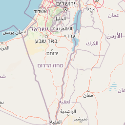
Map view of Masada National Park

Use this park location map to pinpoint Masada National Park in Israel, understand its exact geographic position, and read its mapped placement within the surrounding landscape more clearly.

Pigeon | © OpenStreetMap contributors
Park atlas

Compare Other Protected Areas and National Parks in the Judean Desert, Expanding Your Geographic Exploration Beyond Masada National Park.

Discover Other National Parks and Protected Areas Near Masada National Park, Israel

After exploring Masada National Park's ancient fortress and dramatic desert setting, browse a curated selection of other national parks and protected areas in the surrounding Judean Desert and Dead Sea region. Continue your geographic discovery by comparing nearby archaeological sites, tracing diverse desert landscapes, and understanding the wider regional context of protected lands through mapped park data.
Watercolor illustration of a landscape with green vegetation, a river, and distant hills under a pale sky
Nature reserveIsrael
About 9.4 km away#1 closest

North

Ein Gedi Nature Reserve: Protected Area Exploration and Regional Geography in Israel

Mapped natural terrain and protected landscape context.

Ein Gedi Nature Reserve represents a distinct natural area offering specific geographic discovery. Users can explore its mapped boundaries, understand its unique landscape character, and appreciate its protected status within the diverse terrain of Israel. This page serves as a gateway to understanding the reserve's ecological and geographic significance, providing structured data for those interested in the mapped context of protected lands.

Area
14 km²
Established
1971
Visitors
1M annual
Relief
Lowland
National parkIsrael
About 22 km away#2 closest

West

Tel Arad National Park: Discover Israel's Protected Landscape and Mapped Geography

Explore protected area boundaries and regional terrain context.

Delve into Tel Arad National Park, a key protected area in Israel offering insights into its unique landscape and geographic setting. This park provides a focal point for understanding protected land distribution, mapped terrain features, and the regional natural context within the Levant. Utilize this atlas entry to explore the park's specific geographic identity and conservation significance.

Nature reserveJordan
About 27 km away#3 closest

Northeast

Wadi Mujib Nature Reserve: Explore Jordan's Dramatic Canyon Protected Landscape

Discover mapped boundaries and arid biodiversity within this unique rift valley gorge.

Wadi Mujib Nature Reserve represents a significant protected landscape in Jordan, celebrated for its deep desert canyon and dramatic slot canyon terrain. Situated in the Dead Sea region, this reserve protects a remarkable range of geography, from its lowest points near the Dead Sea to surrounding mountain terrain. Its status as a UNESCO biosphere reserve highlights its importance for arid biodiversity and its role as a migratory bird flyway, offering a distinct atlas-level discovery of Jordan's natural heritage.

Area
212 km²
Established
1987
IUCN
IV
Relief
Mountain
Nature reserveJordan
About 34 km away#4 closest

South

Fifa Nature Reserve Nature Reserve: Protected Landscape Discovery in Jordan

Mapped natural terrain and protected area context.

Fifa Nature Reserve represents a distinct protected natural landscape within Jordan. This entry offers users a detailed atlas-style view of the reserve's protected boundaries and its place within the country's geography. Explore the mapped terrain and understand the significance of this nature reserve for structured geographic discovery and protected-area research.

Area
23.2 km²
Established
2011
Relief
Lowland
Climate
Arid
National parkIsrael
About 40 km away#5 closest

North

Herodion National Park: A Key National Park within Israel's Protected Landscape Atlas

Explore its mapped boundaries and geographic terrain.

Herodion National Park stands as a significant protected area within Israel, contributing vital context to the nation's atlas of natural landscapes. This national park designation highlights its role in conservation and offers a unique opportunity to study its specific geography, terrain, and mapped boundaries. By focusing on the park's protected landscape identity, users can gain structured insights into Israel's conservation efforts and regional geographic features, enhancing any atlas exploration.

Scope
Terrestrial
Watercolor illustration of rolling green hills, a body of water, and grassy vegetation under a light sky.
National parkIsrael
About 42 km away#6 closest

Southwest

Mamshit National Park: Ancient Nabataean City, Byzantine Ruins, and Negev Desert Landscape

Explore exceptionally preserved Nabataean urban architecture and regional geography.

Mamshit National Park offers a rare window into ancient desert urbanism, preserving an exceptionally intact Nabataean caravan city and Byzantine settlement in Israel's Negev Desert. The site showcases unique residential compounds and religious structures, demonstrating sophisticated architectural traditions and water management systems against a backdrop of striking natural terrain. As a vital component of the Incense Road heritage, Mamshit provides rich context for understanding ancient trade, regional geography, and the enduring human adaptation to arid landscapes.

IUCN
V
Relief
Lowland
Climate
Arid
Scope
Terrestrial
Watercolor painting of a landscape with mountains, water, and vegetation
National parkIsrael
About 48 km away#7 closest

North

Qumran National Park: National Park Atlas Exploration and Geographic Context in Israel

Mapped terrain and protected landscape identity in Israel.

Delve into Qumran National Park, a significant national park situated in Israel. This detailed exploration focuses on its protected landscape identity, mapped boundaries, and its place within the country's diverse geography. Understand the unique natural context and regional significance of Qumran National Park through an atlas-driven perspective.

Relief
Lowland
Climate
Arid
Access
Moderate access
Scope
Terrestrial
National parkIsrael
About 49 km away#8 closest

West

Tel Be'er Sheva National Park: Mapped Boundaries and Protected Landscape Identity

Discover its geographic context within Israel's natural terrain.

This MoriAtlas detail page for Tel Be'er Sheva National Park provides focused insights into its identity as a protected landscape. Users can explore its specific geographic setting within Israel, understand its mapped boundaries, and gain a clearer appreciation for its natural terrain. The content is designed to support detailed atlas-based discovery, offering a comprehensive view of the park's protected area characteristics and regional geographic significance.

Common questions about visiting, size, designation, and location context for Masada National Park

Masada National Park FAQs for park facts, access, geography, and protected area context

Find quick answers about Masada National Park, including protected-area facts, park geography, trail and visitor context, and how the park fits into its surrounding country and regional landscape.
MoriAtlas Explorer

Continue Your Protected Areas Search Across the Global Atlas

Deepen your exploration by continuing the structured search for national parks and protected areas worldwide. Utilize the comprehensive filtering capabilities to compare different conservation landscapes and refine your understanding of global park geography. Discover more about the distribution and characteristics of protected natural areas.

Global natural geography