

Why Nimrod Fortress stands out
Nimrod Fortress is best known as one of the largest and most impressive medieval fortifications in the Levant, with its strategic position controlling the ancient trade and military route between Damascus and Galilee. The fortress is notable for its complex architectural evolution spanning Hellenistic, Byzantine, Crusader, Ayyubid, and Mamluk periods, each layer contributing distinct construction styles and structural elements. The site is renowned for its sophisticated defensive features including loopholes, underground cisterns, and the well-preserved keep, as well as the panoramic views it offers over the Golan Heights and the surrounding landscape.
Nimrod Fortress history and protected-area timeline
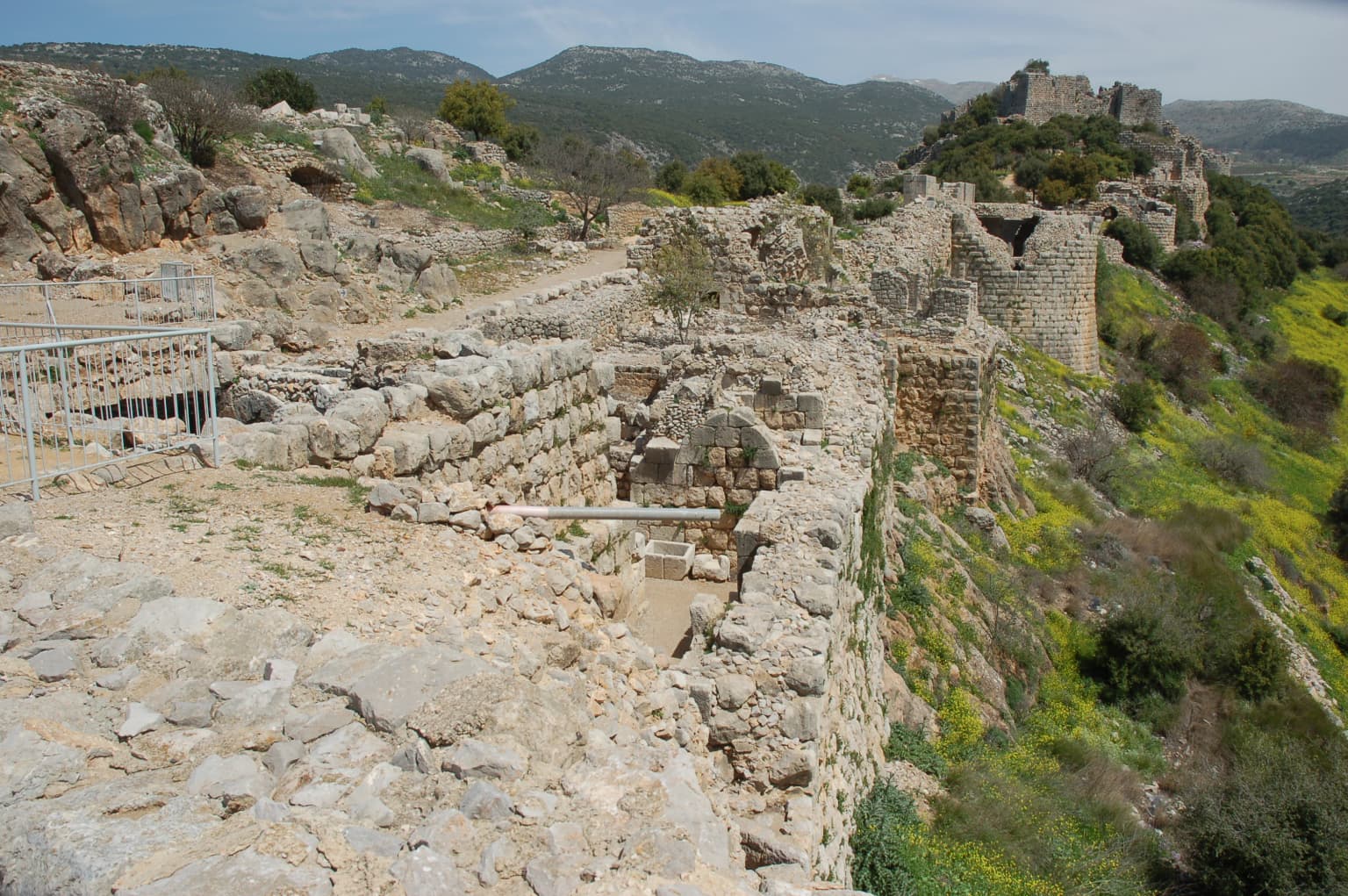
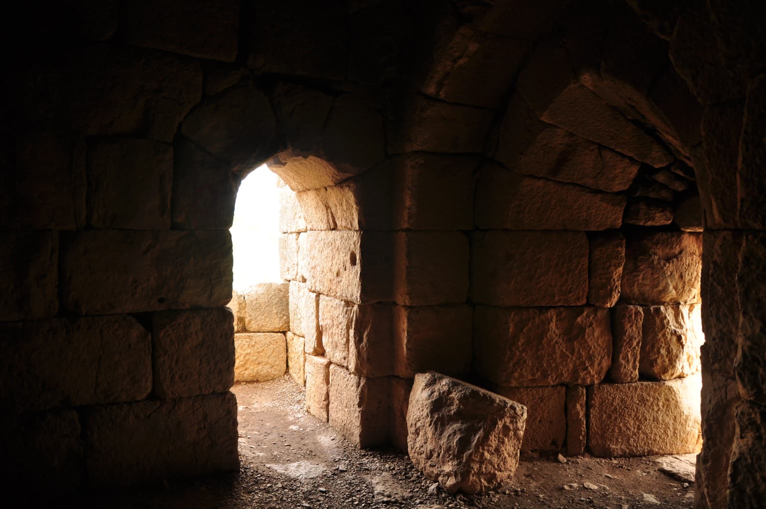
The earliest fortifications at the site likely date to the Hellenistic period, possibly constructed by Greco-Syrian builders after 332 BCE, though the precise origins remain subject to archaeological investigation. The catastrophic earthquake of 749 CE inflicted significant damage on these early structures. A subsequent Crusader building phase is evidenced by the distinctive cross-shaped rib vaults in the Eastern Hall, a construction technique never employed by Muslim builders. The fortress was rebuilt and greatly expanded around 1228 by Al-Aziz Uthman, son of Saladin's brother, in response to the approaches of the Sixth Crusade, and was further enlarged to encompass the entire ridge by 1230. In 1260, Mongol forces captured the fortress, dismantling some defenses before their defeat by the Mamluks at the Battle of Ain Jalut, after which Sultan Baibars strengthened the castle with larger towers and assigned it to his second-in-command Bilik, who undertook extensive construction activities memorialized in a 1275 inscription. Following the Muslim conquest of Acre and the end of Crusader rule in the Holy Land, the fortress lost its strategic significance and fell into disrepair. The Ottoman Turks used the site as a luxury prison for noble prisoners in the 16th century before its abandonment. The fortress was significantly damaged by the 1759 earthquake, and the Druze community that arrived during the 1860 Lebanon conflict began calling the site Qal'at Namrud, associating it with the biblical Nimrod.
Nimrod Fortress landscape and geographic character
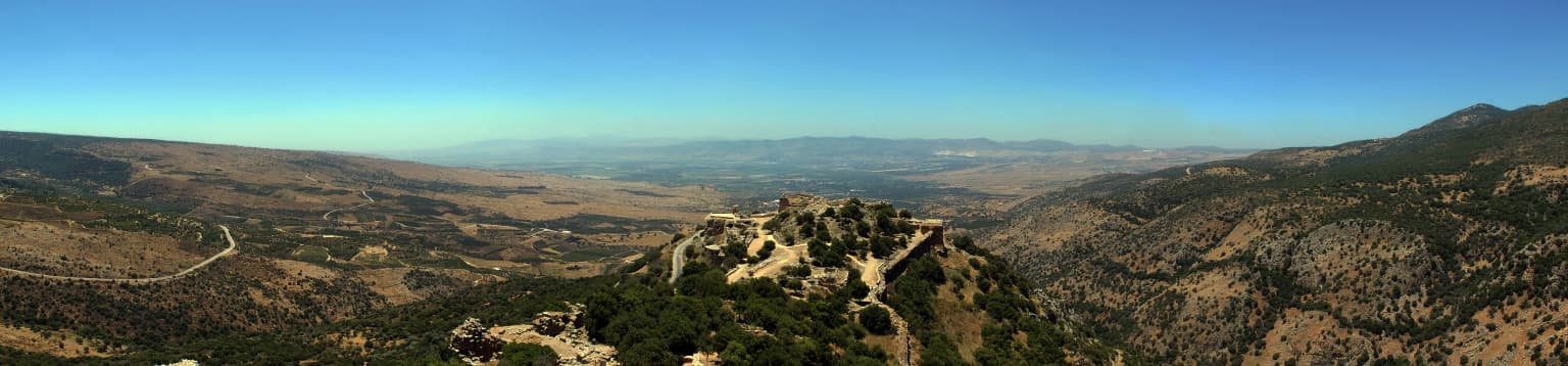
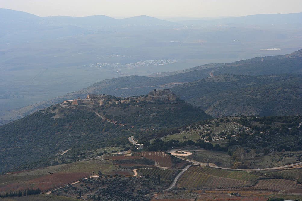
Nimrod Fortress occupies a dramatic position on a ridge along the southern slopes of Mount Hermon, the highest peak in the Anti-Lebanon mountain range. The fortress commands views over a deep, narrow valley that physically separates Mount Hermon from the broader plateau of the Golan Heights. This elevated position at approximately 800 meters above sea level provides strategic visibility over the ancient road connecting the Galilee region with Damascus, as well as over the former Crusader settlement of Banias. The surrounding landscape is characterized by the rocky, semi-arid terrain typical of the northern Golan Heights, with the fortress built from large, carefully squared local stones that blend with the geological character of the ridge.
Nimrod Fortress ecosystems, habitats, and plant life
While Nimrod Fortress is primarily a historical and architectural site rather than a natural landscape, the Golan Heights region in which it is situated encompasses diverse Mediterranean and steppe ecosystems. The area around the fortress includes vegetation communities adapted to the semi-arid conditions at this elevation, with scrubland and grass covering the surrounding slopes. The strategic location along the slopes of Mount Hermon places the site within a transitional zone between the more lush upper elevations of the mountain and the drier Golan plateau.
Nimrod Fortress wildlife and species highlights
The Golan Heights region surrounding Nimrod Fortress supports various wildlife species adapted to the Mediterranean and steppe environments. The area is home to various bird species, small mammals, and reptiles typical of the rocky terrain and scrubland habitats. However, the fortress itself is primarily a historical site rather than a wildlife destination, and detailed wildlife records specific to the immediate fortress area are limited in the source material.
Nimrod Fortress conservation status and protection priorities
The site is managed by the Israel Nature and Parks Authority, which maintains the excavated and restored portions of the fortress for public access and preservation. Conservation efforts have focused on stabilizing the ancient structures, particularly following earthquake damage sustained over the centuries. The designation as a managed historical site within the Golan Heights reflects the broader conservation framework applied to significant cultural heritage locations in the region.
Nimrod Fortress cultural meaning and human context
The cultural context of Nimrod Fortress is deeply intertwined with the complex historical layers of the Levant. The association with the biblical Nimrod, while historically inaccurate, emerged from the Druze community that settled in the area during the 1860 Lebanon conflict, adding a layer of local interpretive tradition to the site. The fortress's strategic position made it a prize for various powers seeking control over the Damascus-Galilee corridor, from Crusader lords to Mamluk sultans. The transition from a military stronghold to an Ottoman prison reflects the evolving functions of such structures as political circumstances changed. The nearby modern Israeli settlement of Nimrod carries the fortress's name into the present day.
Top sights and standout views in Nimrod Fortress
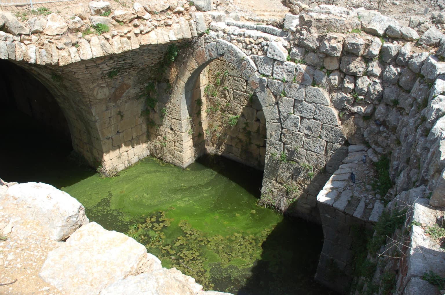
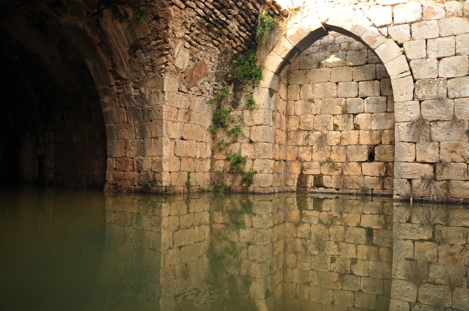
The fortress complex spans 420 meters in length and 150 meters in width, featuring numerous towers and defensive structures. The central keep, measuring 65 by 45 meters, represents the most imposing remaining structure. Visitors can explore secret corridors with winding staircases, underground water cisterns preserving original plaster, and numerous loopholes designed for archers to defend the walls while remaining protected. The western section contains what amounts to a fortress within a fortress, complete with the remnants of a moat and drawbridge, representing the oldest construction phase.
Best time to visit Nimrod Fortress
The site is open to visitors from April through September from 8 a.m. to 5 p.m., and from October through March from 8 a.m. to 4 p.m. The spring and autumn months generally offer comfortable conditions for exploring the extensive ruins, while summer mornings provide good visibility for appreciating the strategic views over the surrounding landscape. Winter visits during the October to March season allow exploration of the site in quieter conditions, though the shorter opening hours should be considered.