Why Tapo-Caparo National Park stands out
Tapo-Caparo is best known for its exceptional forest diversity and its role in protecting the watersheds feeding the Uribante-Caparo hydroelectric system. The park contains some of the most extensive and well-preserved cloud forest habitats in western Venezuela, supporting a remarkable diversity of plant groups including ferns, mosses, lichens, and fungi. The protected area serves as a corridor for large mammals including jaguars, while its river systems and forest edges provide habitat for toucans and other tropical bird species. The dramatic gorges and river valleys cutting through the landscape create scenic beauty and ecological variety that distinguish this park from other protected areas in Venezuela.
Tapo-Caparo National Park history and protected-area timeline
Tapo-Caparo National Park was established by presidential decree on January 14, 1992, during the government of President Carlos Andrés Pérez in his second term. The park was created with the specific purpose of protecting the natural environment in the area surrounding the Uribante-Caparo hydroelectric complex, one of Venezuela's significant infrastructure projects for power generation in the western region. This establishment reflected a growing environmental consciousness in Venezuelan policy during the late 1980s and early 1990s, when several new protected areas were designated to address conservation concerns in rapidly developing regions. The hydroelectric project itself had altered the landscape, and the creation of the national park represented an attempt to balance development with environmental protection by preserving the remaining forest ecosystems in the watershed. The decree recognized that the forests, rivers, and biological diversity of the Tapo-Caparo region constituted a natural heritage worth protecting for future generations.
Tapo-Caparo National Park landscape and geographic character
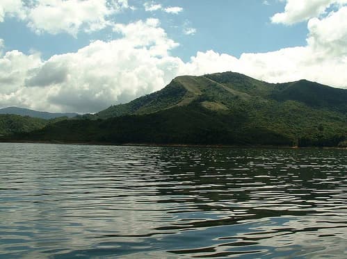
The landscape of Tapo-Caparo National Park is defined by its position in the Andean piedmont, where mountain streams have carved deep valleys and gorges through the forested terrain. The park contains numerous river courses that descend from the higher elevations of the Mérida range, creating a network of watercourses that flow through the protected area. The terrain varies from steep-sided valleys to more gentle slopes as the land descends toward the plains, and this topographic variation creates diverse microhabitats within the park. The forest cover is continuous and dense, with the canopy reaching substantial heights in the more mature forest areas. The combination of river gorges, forest-covered slopes, and the transitional character between mountain and plains ecosystems gives the park a distinctive visual character that distinguishes it from both the higher Andean páramos and the savanna landscapes of the Orinoco region.
Tapo-Caparo National Park ecosystems, habitats, and plant life
The ecological character of Tapo-Caparo National Park reflects its position in the Andean piedmont, a zone of exceptional biological productivity and species diversity. The park features diverse forest types that include both evergreen and semi-deciduous species, with epiphytic vegetation especially well-developed due to the persistent moisture from cloud immersion. The park is notable for its extraordinary diversity of lower plants and fungi, including extensive fern communities, various moss species, lichens, and fungi that form an integral part of the forest ecosystem. These plant groups contribute to the ecological complexity of the park, supporting food webs and providing habitat structure for animals. The moisture regime of the piedmont zone supports this biological richness, creating conditions where plant growth is vigorous and decomposition rates produce rich soils that sustain complex ecological interactions.
Tapo-Caparo National Park wildlife and species highlights
Tapo-Caparo National Park supports a diverse fauna that includes several species of conservation significance. Large mammals are represented by jaguars, the largest cats in the Americas, which roam the forest floors and use the park's river corridors as movement routes. Birdlife includes toucans, characteristic inhabitants of Neotropical forests whose bright plumage and distinctive calls add to the park's natural soundscape. Reptiles are represented by boas, a group of large constrictor snakes that inhabit the forest understory and river margins. This faunal assembly reflects the park's role as a refugium for species that require extensive forest habitats and intact ecological corridors. The combination of forest, river, and gorge habitats within the protected area provides feeding, breeding, and shelter resources for these and many other species.
Tapo-Caparo National Park conservation status and protection priorities
Tapo-Caparo National Park represents an important conservation designation in western Venezuela, protecting forest ecosystems that would otherwise face significant pressure from agricultural expansion and infrastructure development. The park's establishment around the Uribante-Caparo hydroelectric project demonstrates a policy approach that attempts to reconcile development needs with environmental protection. The protected area preserves biodiversity, watershed function, and ecological processes in a region where forest conversion has been extensive. The diversity of plant groups found in the park, including ferns, mosses, lichens, and fungi, represents biological resources that are particularly sensitive to disturbance and benefit from formal protection. The park's large area and contiguity with other forested regions create a conservation unit that can support viable populations of wide-ranging species like jaguars.
Tapo-Caparo National Park cultural meaning and human context
Tapo-Caparo National Park exists within a region of western Venezuela that has been inhabited and used by human communities for generations. The three states encompassed by the park each have distinct regional cultures shaped by their Andean heritage and the traditions of Venezuelan llanero communities in the lower elevations. While the park itself is a modern protected area designation, the landscapes within its boundaries have been shaped by historical patterns of land use and settlement. Thepark's creation reflected evolving attitudes toward environmental protection in Venezuela during the late twentieth century, when the country began establishing more comprehensive protected area networks. The hydroelectric project that motivated the park's creation also reflects the developmental priorities of the region.
Top sights and standout views in Tapo-Caparo National Park
Tapo-Caparo National Park stands out for its exceptional forest diversity, particularly the rich communities of ferns, mosses, lichens, and fungi that characterize its cloud forest environments. The park protects significant populations of jaguars, toucans, and boas within a landscape of dramatic river gorges and intact forest corridors. Its position in the Andean piedmont gives it ecological significance as a transitional zone between high mountain and plains ecosystems. The park's creation around a hydroelectric project demonstrates an important model for integrating conservation with regional development needs.
Best time to visit Tapo-Caparo National Park
The optimal time to visit Tapo-Caparo National Park corresponds to the dry season typical of the Venezuelan Andean region, when precipitation is reduced and trail conditions are more favorable for exploration. The period from December through April generally offers more stable weather conditions, though the park's cloud forest environment means that moisture is present year-round. Visitors interested in wildlife viewing may find the dry season advantageous as animals concentrate around remaining water sources. However, the wet season brings its own rewards, with waterfalls at full flow and the forest at its most lush. Those planning visits should be prepared for the variable conditions typical of piedmont environments, where weather can change rapidly.