
Why Tel Hazor National Park stands out
Tel Hazor is best known for its extraordinary archaeological significance as one of the most powerful Canaanite city-states in ancient times. The site features well-preserved remains including a six-chambered gate from the Israelite period, administrative buildings, and a palace complex. Its cuneiform tablet collection is unparalleled in the region, providing crucial insights into Middle and Late Bronze Age diplomacy, trade, and law codes similar to Hammurabi's Code. The site also preserves evidence of violent destruction layers that some archaeologists correlate with biblical accounts of Joshua's conquest.
Tel Hazor National Park history and protected-area timeline
The history of Tel Hazor spans from the Early Bronze Age II period around the 28th century BCE through successive periods of Canaanite, Egyptian, Israelite, and imperial control. The earliest significant settlement appeared in the Early Bronze Age III period, with evidence of a large monumental structure suggesting urban planning from an early stage. During the Middle Bronze Age II, Hazor served as a vassal state to the kingdom of Qatna and maintained strong Syrian cultural influence. A royal archive from this period includes correspondence with the rulers of Mari and Yamhad, documenting Hazor's role in extensive tin trade networks.
In the Late Bronze Age, Hazor became a major Canaanite city under Egyptian hegemony, appearing in the Amarna letters as a vassal kingdom. The biblical texts describe Hazor as the seat of King Jabin, who led a Canaanite coalition against Israelite forces. Archaeological evidence from the 13th century BCE reveals catastrophic destruction through fire, with debates ongoing among scholars about whether this aligns with biblical accounts of Joshua's conquest or represents other historical events such as internal civil strife or the broader Bronze Age collapse.
Following its destruction, Hazor was rebuilt as a smaller settlement within the territory of Naphtali and was subsequently fortified by Solomon in the 10th century BCE, alongside Megiddo and Gezer. The city experienced periods of Aramaean control and returned to Israelite jurisdiction before its final destruction by the Assyrian ruler Tiglath-Pileser III in 732 BCE, when the population was deported and the city burned.
Tel Hazor National Park landscape and geographic character
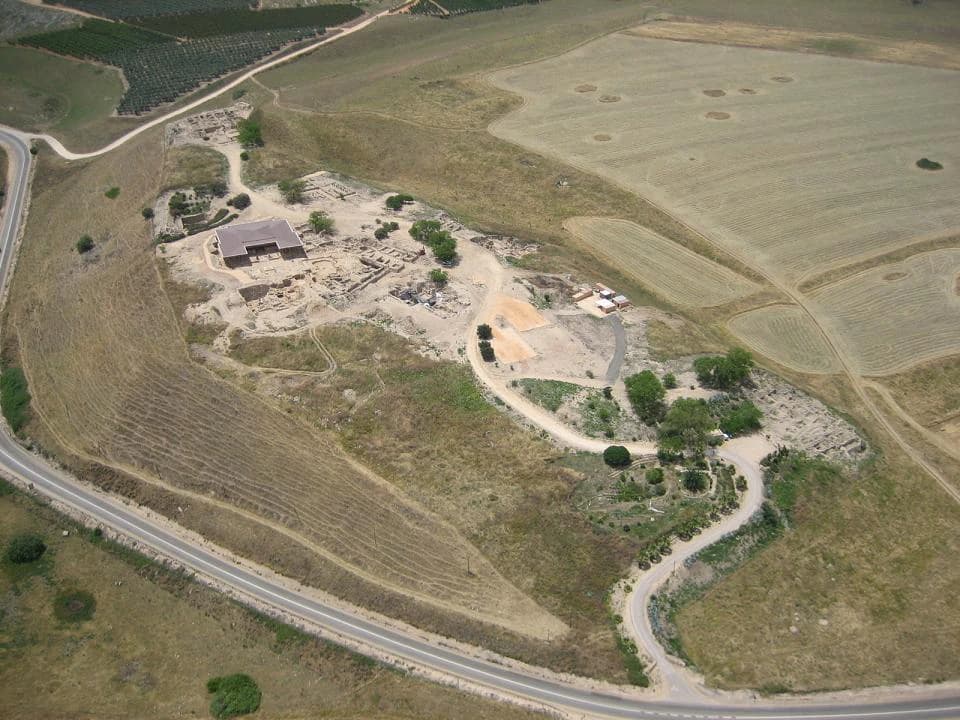
Tel Hazor occupies a strategic position on the Korazim Plateau in Upper Galilee, overlooking the Hula Valley to the north and the Sea of Galilee to the south. The tell consists of two distinct areas: a raised upper city covering approximately 12 hectares and a vast lower city extending over 70 hectares, making it the largest archaeological site in northern Israel. The upper mound rises about 40 meters above the surrounding terrain, providing commanding views across the fertile Galilean landscape. The site's position controlled important ancient trade routes connecting the coastal plains with the inland valleys and trans-Arabian trade networks.
Tel Hazor National Park conservation status and protection priorities
Tel Hazor has been recognized as a UNESCO World Heritage Site since 2005 as part of the Biblical Tells, a transnational serial property including Megiddo and Beer Sheba. This designation reflects the site's outstanding universal value as a testimony to the urban civilization of the Bronze and Iron Ages in the Levant. Ongoing conservation efforts include excavation projects, site preservation, and the maintenance of structures exposed during decades of archaeological work. Artifacts recovered from the site are housed in a museum at Kibbutz Ayelet HaShahar, though some materials were damaged in a 2008 earthquake.
Tel Hazor National Park cultural meaning and human context
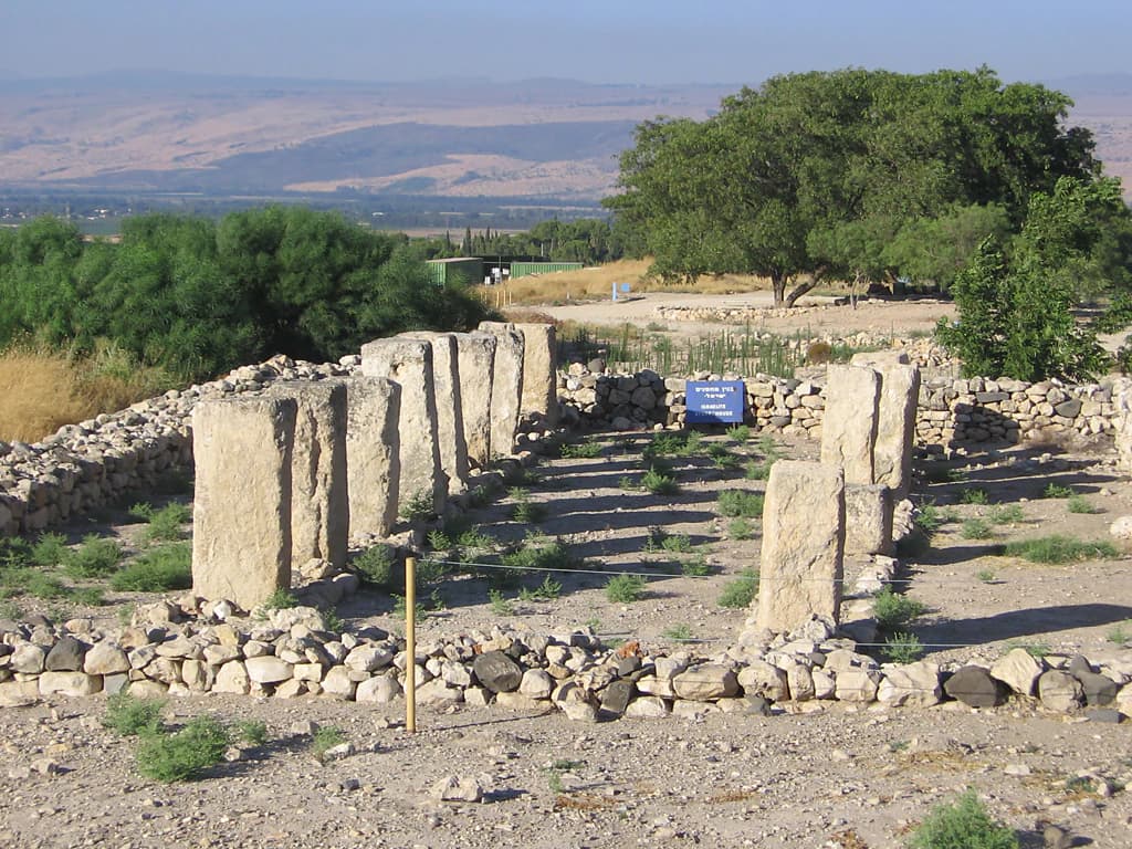
Tel Hazor holds profound significance for biblical archaeology and the study of ancient Israelite history. The site is explicitly mentioned in the Book of Joshua as "the head of all those kingdoms" and in the Book of Judges as the seat of King Jabin, whose commander Sisera led forces against the Israelite leader Barak. The narrative of Deborah and Sisera, preserved in both prose and poetic forms, references Hazor's Canaanite royal lineage. Archaeological discoveries, including a complex of cultic standing stones from Iron Age strata, have been interpreted as evidence of early Israelite presence and the emergence of conquest traditions. The site's extensive archive of cuneiform tablets provides crucial documentary evidence for understanding diplomatic, commercial, and legal practices in the ancient Near East.
Top sights and standout views in Tel Hazor National Park
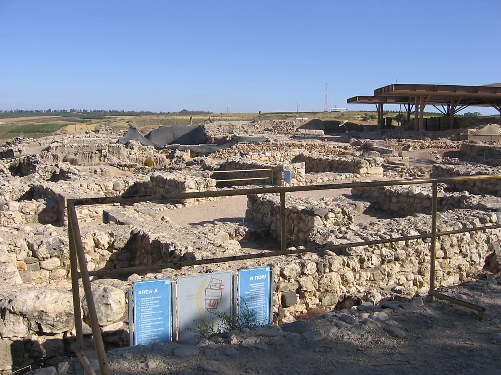
The archaeological highlights of Tel Hazor include the monumental six-chambered gate from the Solomonic period, characteristic of Israelite city planning and similar to gates found at Megiddo and Gezer. The royal fortress gate and administrative palace complexes represent the peak of Canaanite and Israelite architecture. The site's cuneiform tablet collection, exceeding that of any other Southern Levant site, includes legal texts in the style of Hammurabi's Code and the Laws of Eshnunna. The excavated remains preserve both the upper acropolis with its temples and palaces and the extensive lower city with its residential and industrial areas, offering a comprehensive view of ancient urban organization.
Best time to visit Tel Hazor National Park
Tel Hazor can be visited year-round, though the cooler months from October through April offer more comfortable conditions for exploring the extensive outdoor site. Summer temperatures in Galilee can be high, particularly during midday, so early morning or late afternoon visits are advisable during June through September. The site is open to visitors as part of Israel's national park system, and combining a visit with nearby attractions in Upper Galilee, including the Hula Valley and Sea of Galilee, provides a comprehensive historical and geographical experience.