Why Wiang Kosai National Park stands out
Wiang Kosai National Park is best known for its dramatic mountain landscape within the Phi Pan Nam Range, characterized by steep forested peaks, tiered waterfalls, and natural hot springs. The Mae Koeng waterfalls, whose name derives from a local term meaning steps or stairs, represent the park's most-visited attractions, descending in multiple cascades through the mountainous terrain. The Mae Chok hot spring, with water temperatures reaching approximately 80 degrees Celsius, offers a distinct visitor experience within the park's boundaries. The ancient Doi Takhian Thong golden dipterocarp forest, featuring trees estimated at over 100 years old with trunk circumferences requiring three to four people to encircle, provides a notable natural monument within the protected area.
Wiang Kosai National Park history and protected-area timeline
Wiang Kosai National Park was officially established on October 9, 1981, becoming part of Thailand's national park system managed by the Department of National Park, Wildlife and Plant Conservation. The designation came as part of broader efforts in the late 1970s and early 1980s to establish protected areas across Thailand's diverse ecological regions, with particular attention to preserving remaining forest cover in the Northern provinces. Prior to formal protection, the mountainous region had experienced varying degrees of human activity and resource extraction. The establishment of the national park status provided formal legal protection for the forest ecosystems and wildlife habitats within its boundaries, though enforcement and management have continued to evolve over the subsequent decades.
Wiang Kosai National Park landscape and geographic character
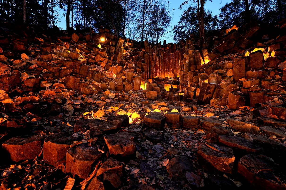
The physical landscape of Wiang Kosai National Park is defined by its position within the Phi Pan Nam Range, a mountainous terrain of steep ridges and deep valleys characteristic of Northern Thailand's highland zones. The terrain exhibits significant elevation variation, rising from approximately 300 metres in the lower foothills to 1,267 metres at Doi Mae Tom, the park's highest summit. The mountain slopes are typically steep and complex, with numerous small streams cutting through the terrain to join the major river systems that originate in the highland zone. Columnar basalt formations appear in certain areas, providing geological interest through their distinctive hexagonal rock columns. The park contains several significant waterfalls, most notably the Mae Koeng Luang and Mae Koeng Noi systems, where water descends in tiered cascades that have earned the waterfalls their local name, as mae koeng translates to staircase or steps in the regional dialect. The Mae Chok hot spring represents another distinct landscape feature, where geothermally heated water emerges from the rocky terrain.
Wiang Kosai National Park ecosystems, habitats, and plant life
The ecological character of Wiang Kosai National Park is shaped by its elevation range, climate regime, and position within the Phi Pan Nam Range. The forest vegetation varies with altitude, with dry evergreen forest dominating the lower slopes and mixed deciduous forest occurring at higher elevations. The park's forest canopy supports a range of biodiversity, though the composition has been affected by historical human activity in the region. The park historically functioned as one of the few remaining areas in Thailand where Asian elephants could roam in essentially natural habitat conditions, and tigers were formerly abundant throughout the mountainous terrain. While these large mammals have become rare or absent from recent observations, the forest ecosystem continues to support populations of smaller mammals including Indian muntjac, tree shrews, and Indochinese flying squirrels. The water systems flowing through the park provide aquatic habitat and contribute to the broader watershed function of the protected area.
Wiang Kosai National Park wildlife and species highlights
The wildlife community in Wiang Kosai National Park reflects the broader forest ecosystems of Northern Thailand, though large mammal populations have diminished from historical levels. The park was once notable as one of the few protected areas in Thailand where Asian elephants maintained populations in natural habitat, and tigers were formerly abundant throughout the mountain forests. Contemporary wildlife observations focus on smaller species including the Indian muntjac, a commonly encountered deer species in the forest understory, the tree shrew, and the Indochinese flying squirrel. The Thai-language source additionally references wild boar, bears, and gaur as species present in the park area. Birdlife and other vertebrate groups occupy the diverse forest habitats, though comprehensive species inventories are not detailed in the available source material.
Wiang Kosai National Park conservation status and protection priorities
Wiang Kosai National Park serves as a protected area within Thailand's national park system, classified under IUCN Category II for national park protection. The park's conservation significance derives from its role in preserving forest ecosystems and watershed function in the Phi Pan Nam Range, along with its historical value as habitat for large mammals including Asian elephants and tigers. The protected area status provides legal framework for limiting deforestation, controlling land-use conversion, and managing visitor impacts within the park boundaries. Management responsibility rests with Thailand's Department of National Park, Wildlife and Plant Conservation, which oversees protection, visitor services, and resource management activities within the park.
Wiang Kosai National Park cultural meaning and human context
Wiang Kosai National Park occupies a region historically associated with Northern Thai communities and the cultural landscape of the Lampang and Phrae Provinces. The local naming of landscape features reflects regional linguistic traditions, as demonstrated by the Mae Koeng waterfalls where the name derives from the local term for staircase or steps. The park lies within territories that have experienced varying degrees of traditional land use by local communities, including activities related to agriculture, forest resource collection, and settlement in surrounding areas. While the park itself is designated as a protected wilderness area, the surrounding landscape maintains connections to regional cultural heritage and traditional livelihoods characteristic of Northern Thailand.
Top sights and standout views in Wiang Kosai National Park
Wiang Kosai National Park offers visitors a combination of natural attractions centered on its mountain landscape, waterfalls, and hot springs. The Mae Koeng waterfall system, featuring both the larger Mae Koeng Luang and smaller Mae Koeng Noi cascades, provides the park's most recognizable natural attractions, with water descending in stepped tiers through the forested valley. The Mae Chok hot spring enables visitor interaction with the park's geothermal features, with water emerging at approximately 80 degrees Celsius. The ancient Doi Takhian Thong forest area contains notable old-growth trees that have become landmark features within the park. The mountainous terrain, while challenging for some visitors, offers hiking opportunities through diverse forest environments and views across the highland landscape.
Best time to visit Wiang Kosai National Park
The optimal period for visiting Wiang Kosai National Park corresponds to the cool dry season typical of Northern Thailand, generally spanning November through February. During these months, temperatures are moderate, rainfall is minimal, and trail conditions are most favorable for hiking and outdoor exploration. The hot season from March through May brings higher temperatures that can make extended outdoor activity more strenuous. The rainy season from June through October increases water flow at the waterfalls, potentially enhancing their visual appeal, but also creates wet trail conditions and potential access limitations. The hot spring can be visited year-round, though the geothermal feature may be particularly appealing during cooler months.