
Why William Bay National Park stands out
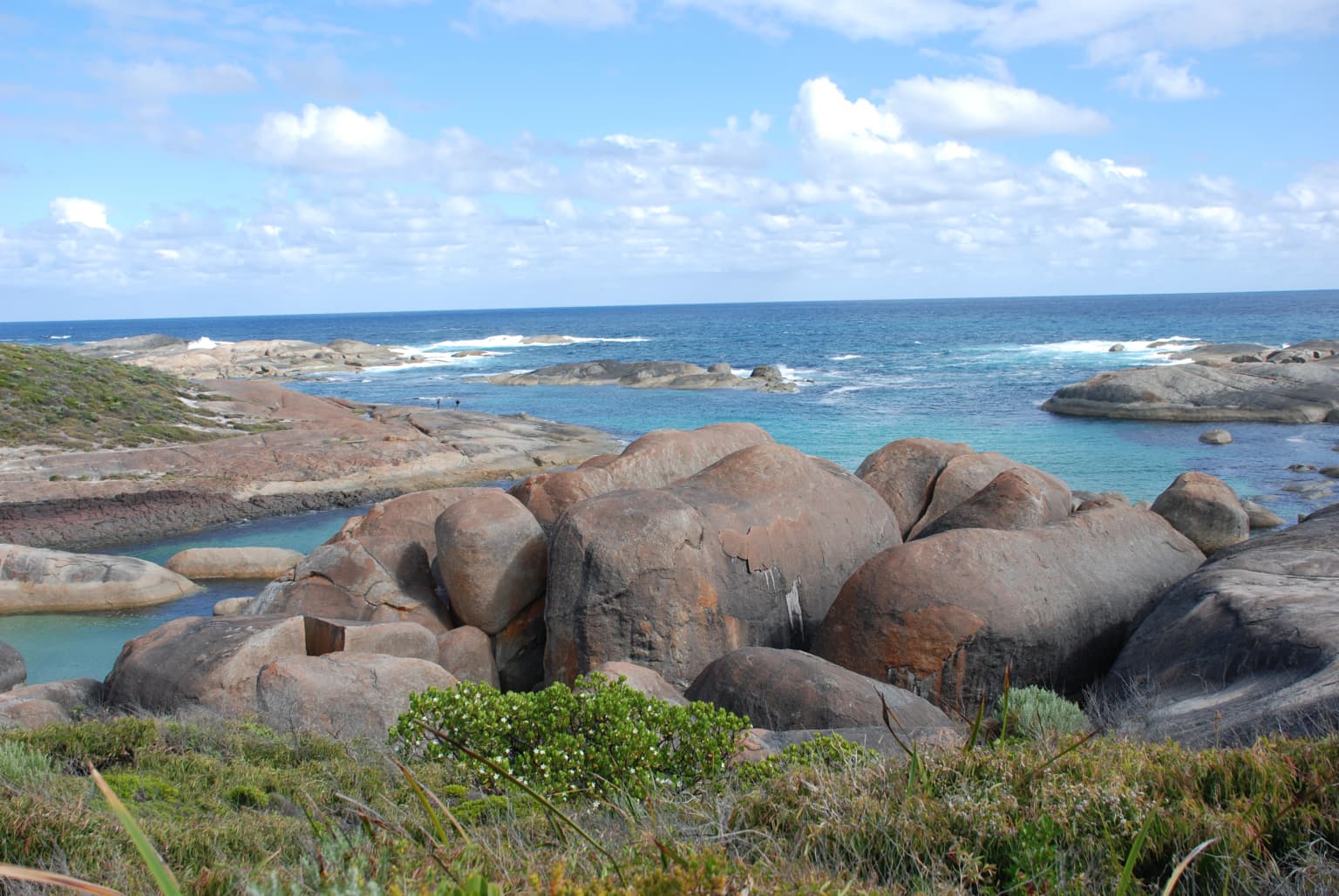
William Bay National Park is best known for two distinctive coastal features: Greens Pool and Elephant Rocks. Greens Pool is a naturally protected swimming area formed by granite boulders that create a reef barrier, sheltering calm, clear waters suitable for supervised swimming. Elephant Rocks refers to a cluster of large rounded granite boulders that form a striking coastal landmark, named for their resemblance to a herd of elephants. These two features anchor the park's identity as a destination where dramatic geology meets accessible, family-friendly coastal recreation. The contrast between the smooth, sun-warmed granite formations and the turquoise waters of the Southern Ocean defines the park's visual character and is the primary draw for visitors.
William Bay National Park history and protected-area timeline
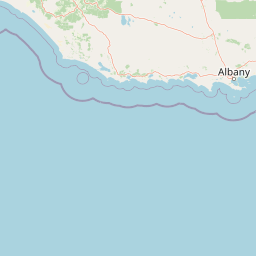
The area now protected as William Bay National Park has been inhabited by Aboriginal Australians for an exceptionally long period, with the traditional owners being the Mineng people. Archaeological evidence including stone tools has been found throughout the park at locations such as Lights Beach, Lake Byleveld, and Parry Inlet, indicating continuous occupation spanning between 40,000 and 50,000 years. The bay itself was named in the 1830s by John Septimus Roe, a significant figure in Western Australia's early colonial administration, in honor of Sir William Edward Parry, the celebrated British Arctic explorer and navigator. Two other nearby geographical features, Parry Inlet and Edward Point, were also named after members of the Parry expedition or family. The area was formally declared a national park in 1971, initially covering 4,644 acres. A small reserve of approximately 29.5 hectares encompassing Lake Byleveld was incorporated into the park during the 1980s, expanding the protected area's coverage. The park has grown in popularity as a tourism destination over the decades, with visitor numbers increasing from 137,000 in 2006-2007 to 238,000 in 2014-2015, demonstrating its enduring appeal as a coastal recreation spot.
William Bay National Park landscape and geographic character
The landscape of William Bay National Park is defined by the intersection of ancient granite formations and the Southern Ocean along the south coast of Western Australia. The park's most recognizable features are the massive rounded granite boulders that dot the coastline, particularly at Elephant Rocks where they form an imposing cluster overlooking the sea. These same granite formations extend beneath the water surface at Greens Pool, where they create a natural reef structure that breaks the power of ocean swells and forms a protected swimming basin. The park's terrain includes coastal cliffs, headlands, sheltered coves, and several beaches ranging from the popular swimming spots of the east to the more remote and windswept shores of the western section. Inland, the land rises into forested hills with exposed granite tors and rocky outcrops punctuating the tree canopy. Parry Inlet cuts through the park's western portion, creating a tidal waterway bordered by dense vegetation. Lakes including Lake Byleveld add still-water environments to the coastal and forest habitats. The overall character blends the rugged exposed coastline typical of the Southern Ocean with the dense green vegetation of the Great Southern region's forests.
William Bay National Park ecosystems, habitats, and plant life
The ecological character of William Bay National Park reflects the transition between several distinct habitat types common to the southwest of Western Australia. The park contains areas of peppermint woodland, where the graceful silhouette of Agonis flexuosa trees creates a distinctive visual element along the more sheltered parts of the park. Dense heathland dominates the exposed coastal sections and lower slopes, supporting the diverse plant communities that characterize this fire-prone Mediterranean climate region. Pockets of karri forest, one of Western Australia's most impressive tree species, occur in the wetter valley floors and more protected areas within the park boundaries. Eucalyptus woodlands add to the forest mix across the park's interior. The coastal heath and forest mosaic supports a range of birdlife, while the wetlands, lakes, and inlet areas provide critical habitat for waterbird species. The granite-dominated coastline creates unique intertidal zones where ocean and land meet, supporting marine and shore species adapted to this dynamic environment.
William Bay National Park wildlife and species highlights
William Bay National Park supports a diverse bird community reflecting its range of habitats from coastal heath through woodlands to wetland areas. Among the most commonly observed bird species are several honeyeater varieties, which feed on the nectar from the park's many flowering plants. The white-breasted robin inhabits the denser understory and forest edges, while the western rosella and red-capped parrot add splashes of color to the woodland canopies. The red-eared firetail is another bird species recorded within the park's boundaries. The park holds particular significance for migratory and resident waterbirds, with several threatened species known to visit the wetland areas. The Australasian bittern, a cryptic ground-dwelling bird of reedbeds and wetlands, uses the park as seasonal habitat. The hooded plover, a shorebird species listed as threatened, breeds and forages along the park's beaches and coastal areas. The little bittern, a small heron species, also visits the park's wetland environments. In 2008, a survey discovered a population of the rare and ancient assassin spider within the park, adding a significant invertebrate species to the park's biodiversity records and prompting conservation attention for this threatened arachnid.
William Bay National Park conservation status and protection priorities
William Bay National Park provides protection for a stretch of Western Australia's south coast that encompasses multiple important ecological communities and species. The park's coastal habitats, while popular for recreation, also serve as critical breeding and foraging grounds for several threatened bird species including the Australasian bittern and hooded plover. The discovery of the rare assassin spider during a 2008 survey highlights the park's significance for invertebrate biodiversity, with this ancient lineage of spiders representing a conservation priority due to its limited distribution and threatened status. The variety of vegetation communities within the park, from coastal heath through peppermint woodlands to karri forest, ensures protection for the region's characteristic plant assemblages. The management of visitor access, particularly to sensitive beach nesting areas used by hooded plovers, represents an ongoing conservation challenge as visitation continues to grow. The park's protection of Parry Inlet and Lake Byleveld ensures that critical wetland habitat remains functional within the broader coastal landscape.
William Bay National Park cultural meaning and human context
The cultural context of William Bay National Park is deeply shaped by the long-standing connection of the Mineng people to this coastal landscape, with archaeological evidence demonstrating continuous Aboriginal occupation for 40,000 to 50,000 years. The Mineng are one of the Noongar peoples whose traditional country spans much of the south coast of Western Australia, and the park area would have provided diverse resources including marine foods from the coast, game from the forests, and plant materials from the heathlands. The naming of William Bay after Sir William Edward Parry by John Septimus Roe in the 1830s reflects the colonial era of European exploration and mapping that imposed new names on the landscape while largely overlooking or ignoring the pre-existing indigenous knowledge and ownership of the land. Today, the park exists at the intersection of these cultural layers, with the traditional owners continuing to hold cultural connections to the area even as it is now managed as a protected area under Western Australian state governance. The physical landscape retains evidence of both the indigenous history, through archaeological sites yielding stone tools, and the colonial history, through the naming of bays, inlets, and points after British explorers.
Top sights and standout views in William Bay National Park
The granite boulder landscape at Elephant Rocks stands as the park's most visually striking geological feature, with massive rounded stones resembling an elephant herd positioned dramatically above the Southern Ocean. Greens Pool offers exceptional swimming opportunities in waters protected from ocean swells by the submerged granite reef, making it one of the most family-friendly swimming beaches on the south coast. The park's location along the Rainbow Coast provides access to a succession of beaches and coves within a relatively compact area, from the popular eastern section to the wilder western beaches. The mix of vegetation communities, from coastal heath through peppermint to karri forest, creates scenic variety along the walking tracks that traverse the park. Parry Inlet adds a tidal waterway environment to the coastal and forest landscapes, offering opportunities for paddling and birdwatching in a different setting from the ocean beaches.
Best time to visit William Bay National Park
The park can be enjoyed throughout the year, though the summer months of December through February typically offer the most reliable warm and dry conditions for beach activities and coastal walking. During this period, visitors can expect longer daylight hours and generally calm conditions suitable for swimming at Greens Pool. The shoulder seasons of spring and autumn also provide excellent conditions, with milder temperatures and fewer crowds compared to peak summer. Winter brings cooler conditions and increased rainfall, which can transform the park's vegetation with fresh growth and flowing waterfalls, though swimming becomes less appealing due to lower temperatures. The park is accessible year-round, though visitors should be prepared for wind at any time, as the southern coast is known for its breezy conditions regardless of season. Birdwatchers may find the migratory waterbird visitations during the cooler months particularly interesting, as species like the Australasian bittern move through the wetland areas.