Mori Atlas logo
National parkForty Mile Scrub National Park

Discover the unique protected terrain, spring-fed waterways, and rare vine thicket of this Queensland national park.

Forty Mile Scrub National Park: Ancient Volcanic Landscape and Relict Ecosystem in Queensland

Forty Mile Scrub National Park represents a crucial protected landscape in Queensland, Australia, offering a rare glimpse into an ancient ecosystem shaped by volcanic geology. This national park preserves a significant remnant of semi-evergreen vine thicket, a relict vegetation community sustained by unique spring-fed stream systems across its mapped terrain. Situated within the Mulga Lands bioregion, its isolation has fostered a distinctive environment, making it a vital ecological refuge and a key destination for exploring the mapped geography of Australia's protected areas.

volcanic landscapessemi-evergreen vine thicketQueensland national parksAustralian protected areasrelict vegetationMulga Lands

Forty Mile Scrub National Park

National park

Park overview

Structured park overview, official facts, and landscape profile for Forty Mile Scrub National Park

Forty Mile Scrub National Park park facts, protected area profile, and essential visitor context
Review the core facts for Forty Mile Scrub National Park, including designation, size, terrain, visitor scale, habitats, and operating context in one park-focused overview.

About Forty Mile Scrub National Park

Forty Mile Scrub National Park represents a remarkable example of ancient landscape preservation in north Queensland, protecting an area of volcanic terrain and relict vegetation that offers insights into ecological conditions spanning millions of years. The park's terrain is characterized by undulating volcanic formations intersected by ancient stream systems that have carved their courses through the landscape over vast time periods. These streams, fed by springs, create permanent water sources in an otherwise semi-arid landscape, supporting vegetation communities that depend on consistent moisture availability. The semi-evergreen vine thicket found within the park is particularly significant, representing a vegetation type that once covered much broader areas but now survives only in isolated pockets where moisture conditions and protection from fire have allowed its persistence. This relict community contains species that are remnants of ancient flora and provides ecological scientists with a living laboratory for studying vegetation dynamics and species survival in changing climatic conditions. The park's location within the Mulga Lands bioregion places it within a broader landscape of semi-arid woodlands and grasslands, making the protected area a critical island of more complex and biodiverse habitat within a region dominated by simpler vegetation structures.

Quick facts and research context for Forty Mile Scrub National Park

Forty Mile Scrub National Park is located in Queensland, Australia, roughly 224 kilometres southwest of Cairns. The park spans 63.3 square kilometres of semi-arid landscape and was formally protected in 1970, receiving IUCN Category II designation as a national park. It is managed by Queensland Parks and Wildlife Service and lies within the Mulga Lands bioregion. The park is distinguished by its ancient volcanic origins, which have produced characteristic stream systems and drainage patterns, and by a preserved pocket of semi-evergreen vine thicket that represents a relict vegetation community of significant scientific interest.

Park context

Deeper park guide and search-rich context for Forty Mile Scrub National Park

Forty Mile Scrub National Park history, landscape, wildlife, and travel context
Explore Forty Mile Scrub National Park through its history, landscape character, ecosystems, wildlife, conservation priorities, cultural context, and seasonal travel timing in a structured park guide built for atlas discovery and search intent.

Why Forty Mile Scrub National Park stands out

Forty Mile Scrub is best known for its ancient volcanic stream systems that have carved distinctive drainage patterns through the landscape, and for protecting a rare isolated pocket of semi-evergreen vine thicket vegetation that survives as a relict community from different climatic conditions. The park is also notable for being home to the largest cockroach species in the world, a remarkable distinction that reflects the park's ecological uniqueness and the evolutionary significance of its isolated habitats. The combination of volcanic geology, spring-fed streams, and preserved ancient vegetation communities makes this park a significant site for understanding long-term ecological processes in semi-arid northern Australia.

Forty Mile Scrub National Park history and protected-area timeline

Forty Mile Scrub National Park was established in 1970, representing an important expansion of Queensland's protected area network into the semi-arid interior of the state. The park's formal protection came at a time when there was growing recognition of the need to preserve unique vegetation communities and geological features that might otherwise be lost to agricultural expansion or resource development. Management of the park was assigned to Queensland Parks and Wildlife Service, which continues to oversee conservation activities and visitor management within the protected area. The creation of the park specifically recognized the scientific and ecological significance of the semi-evergreen vine thicket community and the ancient volcanic landscape features that distinguish this area from surrounding lands.

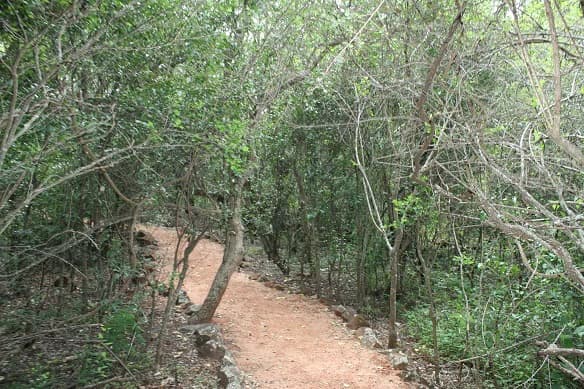
Forty Mile Scrub National Park landscape and geographic character

The landscape of Forty Mile Scrub National Park is fundamentally shaped by its ancient volcanic origins, which have produced a terrain of rolling hills and ridgelines with volcanic bedrock dominating the underlying geology. Ancient stream systems have cut through this terrain, creating well-defined drainage channels that carry water from springs throughout the year. These permanent water sources are a defining feature of the park, providing moisture that supports the more lush vegetation communities found along watercourses and in areas where groundwater surfaces. The combination of volcanic substrates, permanent water availability, and protection from the more extreme fire regimes that affect surrounding lands has allowed distinctive vegetation to establish and persist. The park sits within the broader context of the Mulga Lands, a region characterized by Acacia woodlands and tussel grasslands, making the park's more complex vegetation stand out as a significant ecological contrast to the surrounding landscape.

Forty Mile Scrub National Park ecosystems, habitats, and plant life

The nature of Forty Mile Scrub is defined by the interaction between ancient volcanic geology, permanent water sources, and the survival of relict vegetation communities that represent different climatic periods. The semi-evergreen vine thicket is the most significant vegetation feature, containing species that form a dense, multi-layered canopy unlike the more open woodlands that dominate surrounding areas. This vegetation community survives in an isolated pocket within the park, maintained by the moisture from springs and streams and protected from the fire regime that maintains the surrounding grassland and woodland vegetation. The grass forests that occur in other parts of the park represent another distinctive vegetation type, with dense stands of grass trees and other understory species creating habitat complexity. These diverse vegetation communities support a range of ecological interactions and provide the foundation for the park's biodiversity.

Forty Mile Scrub National Park wildlife and species highlights

Forty Mile Scrub National Park provides habitat for many animal species, both as permanent residents and as occasional visitors. The permanent water sources within the park support species that require reliable water availability throughout the year, while the diverse vegetation communities provide shelter and food resources for a variety of fauna. The park is particularly notable for being home to the largest cockroach species in the world, a remarkable distinction that reflects the unique environmental conditions found here. Koalas are among the species that visit the park, using the vegetation communities as part of their range through the broader landscape. The combination of permanent water, protected shelter, and diverse food resources makes the park an important refuge for wildlife in a region where suitable habitat is often limited.

Forty Mile Scrub National Park conservation status and protection priorities

Forty Mile Scrub National Park is significant from a conservation perspective because it protects one of the last remaining examples of semi-evergreen vine thicket in northern Australia, a vegetation community that represents a relict from past climatic conditions. The preservation of this community within a protected area ensures that scientific understanding of these ecosystems can continue and that the species within them have secure habitat into the future. The park's volcanic stream systems also represent important aquatic habitats in a semi-arid landscape where permanent water is scarce. Management efforts focus on maintaining the ecological integrity of these unique communities while providing appropriate visitor access to appreciate the park's natural values. The park demonstrates how isolated protected areas can serve as critical refuges for species and communities that cannot survive in the surrounding modified landscape.

Forty Mile Scrub National Park cultural meaning and human context

Forty Mile Scrub National Park sits within the broader landscape of north Queensland's semi-arid interior, an area with historical associations with pastoral development and more recent recognition of its natural values. The park's name reflects its location relative to early road distances in the region, a naming convention common in remote Australian landscapes. The land has been part of the broader regional context in which Indigenous peoples and later European pastoralists have interacted with the landscape over different time periods. While the park itself is managed primarily for conservation values, it exists within a regional context of mixed land uses including grazing and mining activities.

Top sights and standout views in Forty Mile Scrub National Park

The defining highlights of Forty Mile Scrub include its ancient volcanic stream systems that provide permanent water through the landscape, the rare and scientifically significant semi-evergreen vine thicket that survives as an isolated relict community, and the presence of the world's largest cockroach species. The park offers a contrasting landscape to the surrounding semi-arid woodlands, with more lush vegetation along watercourses and a distinctive visual character shaped by volcanic geology. These features make the park both ecologically significant and visually distinctive within the Mulga Lands bioregion.

Best time to visit Forty Mile Scrub National Park

The best time to visit Forty Mile Scrub National Park is during the cooler months of the year when daytime temperatures are more comfortable for outdoor exploration. The semi-arid climate means that summer conditions can be hot and dry, while winter brings milder temperatures and lower fire risk. Visiting during the dry season generally provides more reliable access and more comfortable conditions for walking the park's trails and observing its natural features. The permanent water sources in the park maintain their character throughout the year, but the surrounding vegetation and landscape appearance can vary with seasonal conditions.

Park location guide

Geography guide, regional context, and park location map for Forty Mile Scrub National Park

Forty Mile Scrub National Park park geography, regions, and map view in Australia
Understand where Forty Mile Scrub National Park sits in Australia through a broader geographic reading of the surrounding landscape, nearby location context, and its mapped position within the national park landscape.

How Forty Mile Scrub National Park fits into Australia

Australia is a constitutional monarchy and federal parliamentary democracy comprising six states and ten territories. With a population of nearly 28 million, it is one of the world's most urbanised countries, with most people concentrated on the eastern seaboard. The country has a high Human Development Index and is known for its cultural diversity, ancient Aboriginal heritage, and unique wildlife.

Wider geography shaping Forty Mile Scrub National Park in Australia

Australia occupies the entire Australian continent, the island of Tasmania, and numerous smaller islands. It is the world's flattest and driest inhabited continent, featuring vast deserts in the interior (the Outback), tropical rainforests along the eastern coast, and a coastline bordering the Indian and Pacific Oceans.

Map view of Forty Mile Scrub National Park

Use this park location map to pinpoint Forty Mile Scrub National Park in Australia, understand its exact geographic position, and read its mapped placement within the surrounding landscape more clearly.

Pigeon | © OpenStreetMap contributors

Location context for Forty Mile Scrub National Park

Queensland
Park atlas

Map additional protected landscapes and compare park geography across North Queensland.

Explore National Parks and Protected Areas Near Forty Mile Scrub National Park, Queensland
Browse additional national parks and protected areas within North Queensland, uncovering diverse landscapes and ecological zones beyond Forty Mile Scrub National Park. Such a geographic comparison reveals the broader protected-area network, tracing how different sites contribute to the ecological integrity of Queensland's varied terrains.
National parkTablelands Region

Koombooloomba National Park: Endangered Wet Sclerophyll Forest Atlas & Geographic Discovery

Mapping the protected landscape of this Queensland national park.

Koombooloomba National Park serves as a vital sanctuary for one of eastern Australia's most endangered forest types, wet sclerophyll forest. Its inclusion within the Wet Tropics World Heritage Area highlights its global ecological importance, preserving ancient rainforest ecosystems and unique regional biodiversity. This detailed entry offers an atlas-driven perspective on the park's protected boundaries and its distinct landscape, situated within the Tablelands Region's geography.

Area
292.58 km²
IUCN
II
Climate
Tropical
Scope
Terrestrial
National parkQueensland

Millstream Falls National Park: Australia's Widest Single-Drop Waterfall and Queensland Geography

Explore the mapped boundaries and unique landscape of this significant national park.

Millstream Falls National Park, a protected area in Far North Queensland, Australia, stands out for its impressive Big Millstream Falls, recognized as the widest single-drop waterfall in the country. This national park provides a concentrated study of volcanic geology and tropical landscape, with the waterfall cascading over a basalt cliff amid lush vegetation. As a key component of Queensland's protected lands, its mapped boundaries and regional geographic context are essential for understanding this unique natural feature. The park's compact size and dramatic scenery offer a distinct atlas point for exploring Australia's diverse natural heritage.

Area
3.72 km²
IUCN
II
National parkQueensland

Tully Gorge National Park: Queensland National Park Landscape and Geography

Explore mapped boundaries and regional terrain context.

Delve into the protected landscape of Tully Gorge National Park, a key national park located in Queensland. This resource provides insights into its geographic positioning, mapped park boundaries, and the surrounding natural terrain, offering a valuable perspective for atlas exploration and understanding Australia's protected areas.

Area
543 km²
Established
1923
IUCN
II
National parkTablelands Region

Herberton Range National Park: Protected Landscape and Regional Geographic Context

Explore mapped forest ecosystems and watershed importance in North Queensland.

Herberton Range National Park represents a crucial protected landscape within Australia's Tablelands Region. This national park is notable for preserving endangered wet sclerophyll forests, a vital ecosystem that has diminished across Queensland. Its boundaries encompass a rich mosaic of tropical rainforest and open forest, contributing to ecological diversity and providing essential watershed protection for three major river systems. The park's location offers a compelling case study in regional land conservation and landscape mapping.

Area
65.36 km²
Established
2008
IUCN
II
National parkQueensland

Hasties Swamp National Park: A Queensland National Park for Wetland Birdwatching

Discover unique seasonal wetland and eucalypt forest landscapes.

Hasties Swamp National Park in Queensland, Australia, offers a unique ecological focus as a protected wetland area. Its primary significance lies in its role as a crucial habitat for an extensive array of bird species, including the notable sarus crane. The landscape is characterized by a seasonal wetland surrounded by open eucalypt forests, providing rich natural context. This compact national park is ideal for understanding specific wetland ecosystems and their role within the broader regional geography.

Area
0.57 km²
Established
1980
IUCN
II
Relief
Upland
National parkQueensland

Crater Lakes National Park: Queensland's Volcanic Crater Lakes and Ancient Rainforest Atlas

Explore the mapped boundaries and natural geography of this protected landscape.

Crater Lakes National Park in Queensland, Australia, preserves two spectacular volcanic crater lakes formed by ancient phreatomagmatic eruptions. This protected area is renowned for its unique geological formations, including Lake Barrine and Lake Eacham, set amidst a lush subtropical rainforest dotted with iconic giant bull kauri pines. Dive into the detailed geography and mapped landscape context of this significant national park, offering insights into its volcanic origins and ecological significance within the Wet Tropics.

Area
9.59 km²
Established
1994
IUCN
II
National parkQueensland

Clump Mountain National Park: Queensland's Tropical Rainforest Protected Area Atlas

Discover mapped rainforest terrain and key cassowary habitat.

Clump Mountain National Park in Queensland is a compact yet ecologically rich protected area focused on preserving tropical rainforest. This national park serves as vital habitat for the endangered southern cassowary, highlighting its importance within Australia's Wet Tropics region. Visitors can explore the mapped boundaries and understand the unique landscape context of this significant conservation site, offering a focused view of regional protected lands and their environmental significance.

Area
2.82 km²
Established
1963
IUCN
II
National parkQueensland

Hann Tableland National Park: Queensland's Upland Forest National Park

Explore mapped boundaries and unique protected landscape.

Hann Tableland National Park, located in Queensland, Australia, is a protected area safeguarding a unique upland forest landscape within the Einasleigh Uplands. This national park is particularly notable for its conservation efforts for threatened marsupial species, including the northern greater glider and northern quoll, alongside the buff-breasted button-quail. Its relatively remote character and undeveloped natural environment offer a wilderness experience distinct from more accessible parks. Discover the mapped geography and protected-area context of Hann Tableland National Park, a vital component of northern Queensland's conservation landscape.

Area
108.2 km²
Established
1989
IUCN
II

Common questions about visiting, size, designation, and location context for Forty Mile Scrub National Park

Forty Mile Scrub National Park FAQs for park facts, access, geography, and protected area context
Find quick answers about Forty Mile Scrub National Park, including protected-area facts, park geography, trail and visitor context, and how the park fits into its surrounding country and regional landscape.
MoriAtlas Explorer

Continue Your Protected Areas Search Across the Global Atlas

Deepen your exploration by continuing the structured search for national parks and protected areas worldwide. Utilize the comprehensive filtering capabilities to compare different conservation landscapes and refine your understanding of global park geography. Discover more about the distribution and characteristics of protected natural areas.

Global natural geography