


Mori Atlas logo
Protected areaMount Wilhelm

Discover the mapped geography and protected landscape of Oceania's dramatic granite peak.

Mount Wilhelm Protected Area: Papua New Guinea's Highest Peak and Alpine Landscape

Mount Wilhelm stands as Papua New Guinea's highest mountain and a significant protected area, rising dramatically in the Bismarck Range. This granite peak, reaching 4,509 meters, offers a unique high-altitude environment from tropical rainforest to alpine grasslands. Its dramatic summit, twin glacial lakes, and role as a prominent geographic landmark provide essential context for understanding the nation's diverse protected landscapes and regional geography.

Mountain peaksBismarck RangeHighlandsAlpine environmentsSeven SummitsClimbing destinations
Stylized illustration of a mountain with waterfalls, river, and trees under a bright sky with clouds

Mount Wilhelm

Protected area

Park overview

Structured park overview, official facts, and landscape profile for Mount Wilhelm

Mount Wilhelm park facts, protected area profile, and essential visitor context

Review the core facts for Mount Wilhelm, including designation, size, terrain, visitor scale, habitats, and operating context in one park-focused overview.

About Mount Wilhelm

Mount Wilhelm dominates the central highlands of Papua New Guinea as the nation's tallest peak, standing 4,509 metres above sea level within the Bismarck Range. The mountain's location at the meeting point of three provinces Chimbu, Jiwaka and Madang reflects its importance as a geographic landmark that transcends administrative boundaries. The indigenous Kuman-speaking people refer to the peak as Enduwa Kombuglu or Kombugl'o Dimbin, names that carry cultural weight and connect the landscape to local heritage. Unlike many of the world's highest peaks, Mount Wilhelm is relatively accessible to climbers without technical mountaineering skills, though the terrain remains challenging, particularly in wet weather conditions. The mountain's ecological diversity is striking, transitioning from tropical montane forest at lower elevations through cloud forest zones to alpine grasslands and rocky summit terrain. Climbers who reach the peak at dawn are often rewarded with clear views across the highlands and a visual sense of the mountain's prominence in the regional landscape.

Quick facts and research context for Mount Wilhelm

Mount Wilhelm rises 2,969 metres above the surrounding terrain, making it one of the most prominent peaks in Papua New Guinea and ranking 97th in the world by topographic prominence. The mountain was first successfully ascended in August 1938 by government patrol officer Leigh Vial, who noted the surprising presence of snow near the summit despite the equatorial location. The peak can be reached via two primary routes, with the more accessible path beginning from the village of Keglsugl in Simbu Province and ascending through montane rainforest to the twin lakes of Piunde and Aunde before reaching the summit.

Protection and recognition

Tracking documented conservation scope, terrestrial boundaries, and international status.

Mount Wilhelm Protection Status and Documented Terrestrial Area Designations

Land-based protection frameworks define the conservation parameters for the terrestrial environments of Mount Wilhelm. Reviewing documented designations, transboundary status, and official database records helps researchers analyze the global classification of high-elevation geographic zones.

Protection details

Protection scope
Terrestrial
Park context

Deeper park guide and search-rich context for Mount Wilhelm

Mount Wilhelm history, landscape, wildlife, and travel context

Explore Mount Wilhelm through its history, landscape character, ecosystems, wildlife, conservation priorities, cultural context, and seasonal travel timing in a structured park guide built for atlas discovery and search intent.

Why Mount Wilhelm stands out

Mount Wilhelm is best known as the highest mountain in Papua New Guinea and one of the highest peaks in Oceania, making it a premier climbing destination in the region. The mountain is celebrated for its dramatic summit views, the twin lakes of Piunde and Aunde located near the alpine zone, and the challenge of ascending a high-latitude tropical peak. Its status as part of the Seven Summits list attracts international mountaineers seeking to climb the highest point in each continental region. The mountain also holds historical significance from a World War II aircraft crash and has been the site of several climbing fatalities that have become part of its layered history.
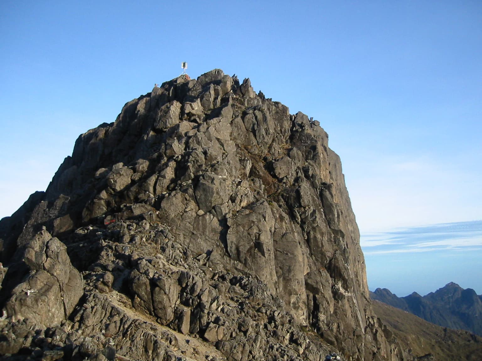
Rocky mountain peak with a small structure visible at the summit against a clear blue sky
Mount Wilhelm peak with a small structure visible at the summit

Mount Wilhelm history and protected-area timeline

The naming of Mount Wilhelm dates to 1888 when German newspaper correspondent Hugo Zöller climbed the Finisterre Range and named the Bismarck Range after Chancellor Otto von Bismarck, assigning the highest peaks names from his family including Ottoberg, Herbertberg, Marienberg and Wilhelmberg. Zöller initially believed Ottoberg to be the highest peak at 3,540 metres, but later exploration revealed the distant Wilhelmberg to be far taller. The first recorded successful ascent was achieved on August 15, 1938 by Leigh Vial, a government patrol officer, accompanied by two local guides. Vial documented that despite the mountain's proximity to the equator, snow was present near the summit during his ascent. During World War II, an American F-7A Liberator aircraft crashed into the mountain on May 22, 1944, while on a reconnaissance mission, with wreckage remaining visible in the highest lake. The mountain has unfortunately been the site of several climbing fatalities over the decades, including an Australian Army Sergeant in 1971, an Israeli backpacker in 1995, an Air Niugini marketing manager in 2005, and local residents in subsequent years.

Mount Wilhelm landscape and geographic character

Mount Wilhelm rises as a dramatic granite peak within the Bismarck Range, a mountain system that forms a significant spine through the highlands of Papua New Guinea. The mountain's topography features steep forested slopes that give way to alpine zones as elevation increases. Near the summit, the landscape includes the twin lakes of Piunde and Aunde, which sit in glacial valleys carved into the mountain's upper reaches. These lakes represent unique high-altitude aquatic features in a region where such bodies of water are rare. The terrain along climbing routes includes dense mountain rainforest, open alpine grasslands, and rocky sections that require careful navigation. The mountain's prominence of 2,969 metres creates a distinctive profile visible from considerable distances across the highlands, establishing it as a landmark feature of the Papua New Guinean landscape.

Mount Wilhelm ecosystems, habitats, and plant life

The ecological character of Mount Wilhelm is defined by its dramatic elevation gradient, which supports multiple distinct habitat zones within a relatively short vertical distance. The lower slopes are cloaked in tropical montane rainforest characterized by dense vegetation, high humidity, and rich biodiversity. As elevation increases, the forest transitions into cloud forest where persistent mist and reduced temperature create specialized conditions for unique plant species. The alpine grassland zone near the summit supports vegetation adapted to cooler temperatures and higher UV exposure. The presence of snow at the summit despite the equatorial location reflects the phenomenon that temperatures at high elevations in the tropics can drop significantly below those at sea level, creating conditions more typical of much higher latitudes.

Mount Wilhelm wildlife and species highlights

While the Wikipedia source does not provide detailed information on wildlife at Mount Wilhelm, the various ecological zones from tropical rainforest to alpine grassland suggest the presence of diverse fauna adapted to each habitat type. The montane and cloud forest zones would typically support populations of birds, including species of parrots, honeyeaters, and birds of paradise that characterize Papua New Guinea's rich avifauna. Small mammals, reptiles, and invertebrates would occupy the diverse microhabitats created by the mountain's complex terrain. The alpine zones would support fewer species but would host specialized organisms adapted to high-altitude conditions. Papua New Guinea generally is recognized as one of the world's biodiversity hotspots, and Mount Wilhelm's multiple elevation zones create conditions that support this remarkable diversity.

Mount Wilhelm conservation status and protection priorities

Mount Wilhelm's status as the nation's highest peak and a significant natural landmark has elevated its importance in Papua New Guinea's conservation framework. The mountain's ecosystems represent unique high-altitude environments within the island of New Guinea, one of the world's most biologically diverse landmasses. While the source does not specify formal protected area designations, the mountain's ecological significance and cultural value to local communities provide informal protection. The twin lakes of Piunde and Aunde represent sensitive aquatic environments that would benefit from conservation attention. The challenge of balancing mountaineering access with environmental protection remains relevant as the mountain attracts increasing numbers of climbers seeking to experience this significant natural landmark.

Mount Wilhelm cultural meaning and human context

Mount Wilhelm holds deep cultural significance for the Kuman-speaking people of the region, who have lived in the mountain's vicinity for generations. The peak is known locally as Enduwa Kombuglu or Kombugl'o Dimbin, names that reflect this indigenous connection to the landscape. The mountain's intersection of three provinces Chimbu, Jiwaka and Madang reflects its importance as a geographic landmark that unifies rather than divides the regional community. Local guides have played essential roles in expeditions to the mountain since the first recorded ascent in 1938, and their knowledge of the terrain, weather patterns, and routes has been crucial to climbing success. The plaques commemorating those who have died on the mountain, including local residents, represent the human dimension of the mountain's history and its ongoing significance to the community.

Top sights and standout views in Mount Wilhelm

The summit of Papua New Guinea's highest mountain offers climbers spectacular panoramic views across the highlands and a profound sense of standing at the top of the nation. The twin lakes of Piunde and Aunde, located in glacial valleys near the alpine zone, provide scenic rest points during the climb and represent rare high-altitude lakes in Papua New Guinea. The transition through multiple ecological zones from tropical rainforest to alpine grassland offers a condensed demonstration of tropical mountain ecology. The historical layers of the mountain, from its indigenous significance to its colonial naming and World War II history, create a rich contextual experience beyond the physical challenge of the ascent.

Best time to visit Mount Wilhelm

Mount Wilhelm can be climbed throughout the year, though conditions vary with Papua New Guinea's wet and dry seasons. The dry season typically offers more stable weather and clearer summit views, reducing the risks associated with wet and slippery trail conditions. Climbers often begin their ascent during the night to reach the summit at dawn, when weather conditions are most likely to be clear and the mountain's full prominence is visible across the highlands. The mountain's equatorial location means that temperature differences between base and summit are significant, requiring appropriate layered clothing and equipment. Weather on the mountain can change rapidly regardless of season, and climbers should be prepared for both clear conditions and the possibility of fog, rain, or even snow near the summit.

Monthly climate preview

Mapped temperature averages and precipitation trends at the representative elevation

Mount Wilhelm Climate History and Representative Monthly Weather Patterns

Long term climatology data from the representative coordinate reveals a mild temperature pattern alongside varying daily precipitation levels throughout the annual cycle. Accessing the complete monthly profile provides detailed minimum, maximum, and mean measurements alongside wet and dry trends for deeper geographic comparison.
Annual mean17 °C
17 °C18 °C
Jan18°
Feb18°
Mar17°
Apr17°
May17°
Jun17°
Jul17°
Aug17°
Sep17°
Oct18°
Nov18°
Dec18°
Warmest month
December

17.7 °C

Coolest month
July

16.8 °C

Wettest month
March

7.4 mm/day

Driest month
August

2.3 mm/day

Park location guide

Geography guide, regional context, and park location map for Mount Wilhelm

Mount Wilhelm park geography, regions, and map view in Papua New Guinea

Understand where Mount Wilhelm sits in Papua New Guinea through a broader geographic reading of the surrounding landscape, nearby location context, and its mapped position within the national park landscape.

How Mount Wilhelm fits into Papua New Guinea

Papua New Guinea is an island nation in the southwestern Pacific Ocean, comprising the eastern half of the island of New Guinea and hundreds of offshore islands. It gained independence from Australia in 1975 and operates as a constitutional monarchy within the Commonwealth. The country is renowned for having the world's highest linguistic diversity, with over 840 known languages.

Wider geography shaping Mount Wilhelm in Papua New Guinea

Papua New Guinea occupies the eastern half of the island of New Guinea and hundreds of smaller islands in Melanesia. It shares a land border with Indonesia to the west and has maritime boundaries with Australia to the south and the Solomon Islands to the east. The terrain is predominantly mountainous, with the land supporting extraordinary biodiversity.

Map view of Mount Wilhelm

Use this park location map to pinpoint Mount Wilhelm in Papua New Guinea, understand its exact geographic position, and read its mapped placement within the surrounding landscape more clearly.

Pigeon | © OpenStreetMap contributors

Location context for Mount Wilhelm

Chimbu ProvinceJiwaka ProvinceMadang Province

Uncover the unique mountain environments, from dense tropical rainforests to high-altitude glacial lakes, through captivating imagery.

Mount Wilhelm Photos: Visualizing Papua New Guinea's Alpine Peaks and Protected Landscapes

Browse a curated collection of Mount Wilhelm images, showcasing its dramatic granite peak, alpine grasslands, and unique high-altitude lakes. These visual insights reveal the mountain's transition through diverse ecological zones, offering a clearer understanding of its protected landscapes and challenging terrain.

Rocky mountain peak with a small structure visible at the summit against a clear blue sky

Satellite image showing Mount Wilhelm's snow-capped peaks, green valleys, and Ramu River in the distance

Park atlas

Explore the surrounding Bismarck Range and Papua New Guinea highlands, comparing diverse protected landscapes.

Discover Nearby National Parks and Protected Areas Beyond Mount Wilhelm in Papua New Guinea

Continue your exploration from Mount Wilhelm by browsing other national parks and protected areas located across the Papua New Guinea highlands, tracing the regional spread of conservation landscapes. Compare varied park geography and alpine environments adjacent to the Bismarck Range, gaining deeper insights into Oceania's unique protected natural areas.
Wildlife reserveChimbu Province
About 101 km away#1 closest

South

Crater Mountain Wildlife Management Area: Geography and Protected Land Boundaries in Chimbu Province

Central highland rainforest and cordillera wilderness terrain.

Crater Mountain Wildlife Management Area encompasses a massive tract of undisturbed highland rainforest across the central cordillera of Papua New Guinea. This protected zone demonstrates a unique intersection of tropical montane biodiversity and community-led conservation, providing an essential refuge defined by steep topography, persistent moisture, and continuous forest cover that stretches across the Chimbu Province.

Relief
Highland
Water
Major water bodies
Nature reserveWestern Highlands Province
About 102 km away#2 closest

West

Baiyer River Sanctuary: Protected Highland Rainforest and River Valley Geography

Nature reserve in the Western Highlands Province of Papua New Guinea.

Located within the Western Highlands, Baiyer River Sanctuary protects 740 hectares of dense oak-dominated rainforest. This nature reserve provides essential habitat for birds-of-paradise, maintaining a continuous canopy across high-rainfall mountain slopes that bridges the transition between lowland and alpine ecosystems.

Area
7.4 km²
Established
1968
Relief
Upland
Climate
Tropical
Wildlife reserveMorobe Province
About 196 km away#3 closest

East

YUS Conservation Area: Mapping the Geographic Range of a Community-Led Wildlife Reserve

Protected tropical forest landscapes in Morobe Province, Papua New Guinea

YUS Conservation Area represents a significant shift in regional conservation, protecting a massive altitudinal gradient on the Huon Peninsula. From coastal coral reef environments to the rugged ridges of the Saruwaged Mountains, the area preserves critical montane habitats and riverine corridors. This dataset provides insight into its unique geography, spanning lowland forests to highland peaks while showcasing a model of land management driven by customary community agreements.

Area
760 km²
Established
2009
Relief
Mountain
Climate
Tropical
Wildlife reserveSouthern Highlands Province
About 200 km away#4 closest

West

Lake Kutubu Wildlife Reserve: Geographic Boundaries and Highland Ecosystem Mapping

Protected freshwater terrain in the Southern Highlands Province

Lake Kutubu represents an essential protected landscape in the Papua New Guinea highlands, serving as a critical upland basin for diverse freshwater species. This overview highlights the reserve's unique geographic setting, covering its expansive 19-kilometer stretch, surrounding montane forests, and its role within the Kikori River catchment. Access detailed landscape context and regional environmental data for this globally significant lacustrine ecosystem.

Area
51.84 km²
Relief
Mountain
Scope
Terrestrial
Water
Water-dominated
National parkMorobe Province
About 240 km away#5 closest

Southeast

McAdam National Park; Geographic Atlas of Protected Highland Forests in Morobe Province

Highland montane forest and rugged ridge landscapes

McAdam National Park preserves a rugged stretch of montane rainforest in Papua New Guinea's Bulolo region. Rising over 1,200 meters, this protected area features steep forested slopes and narrow valleys that define the geography of the Morobe interior. Our atlas provides insights into the park's boundaries and its position within the broader highland ecosystem of the province.

Relief
Mountain
Scope
Terrestrial
Water
Minor water
National parkCentral Province
About 478 km away#6 closest

Southeast

Varirata National Park: Protected Rainforest and Highland Terrain Atlas

Mapped geography of Central Province rainforest reserves

Varirata National Park is a significant protected area within the Central Province of Papua New Guinea, known for its elevated tropical rainforest ridges and varied topography. This map-based entry provides context on its landscape character, environmental setting, and role as an essential forest refuge in the highlands near the national capital.

Relief
Highland
Water
Minor water
National parkSouth Papua
About 508 km away#7 closest

Southwest

Wasur National Park National Park: Mapped Protected Boundaries in South Papua

Explore the geographic context and park boundaries.

Delve into the specific protected area identity of Wasur National Park, a national park situated within the South Papua region. This page offers detailed geographic context, focusing on its mapped boundaries and its significance as a protected landscape. It provides a factual basis for understanding the park's place within Indonesia's network of natural areas for structured atlas exploration.

Area
4,138 km²
Established
1990
IUCN
II
Visitors
2.3K annual
Wildlife reserveWestern Province
About 523 km away#8 closest

Southwest

Tonda Wildlife Management Area: Atlas of Protected Wetlands and Savanna Landscapes

Geographic overview of Papua New Guinea's largest wetland conservation zone

Spanning nearly 6,000 square kilometres of floodplain, Tonda Wildlife Management Area is defined by its exceptionally flat terrain and shifting mosaic of monsoon forest, tidal channels, and freshwater marshes. This protected landscape functions as an essential ecological bridge within the Trans-Fly ecoregion, maintaining deep connections to international conservation partners while preserving the integrity of its native bird and mammal habitats.

Area
5,900 km²
Established
1975

Common questions about visiting, size, designation, and location context for Mount Wilhelm

Mount Wilhelm FAQs for park facts, access, geography, and protected area context

Find quick answers about Mount Wilhelm, including protected-area facts, park geography, trail and visitor context, and how the park fits into its surrounding country and regional landscape.
MoriAtlas Explorer

Continue Your Protected Areas Search Across the Global Atlas

Deepen your exploration by continuing the structured search for national parks and protected areas worldwide. Utilize the comprehensive filtering capabilities to compare different conservation landscapes and refine your understanding of global park geography. Discover more about the distribution and characteristics of protected natural areas.

Global natural geography