

Mori Atlas logo
National parkLorentz National Park

Discover the mapped boundaries and regional landscape context of this vital protected area.

Lorentz National Park: Central Papua's Premier National Park for Geographic Exploration

Lorentz National Park stands as a significant national park within the expansive geography of Central Papua. This page provides an atlas-focused exploration of its protected landscape, detailing its geographic scope, mapped terrain, and the regional context it inhabits. Understand the park's presence as a distinct protected area and its role in the natural landscape of Indonesia.

tropical rainforestmontane forestalpine tundramangrovewetlandWorld Heritage Site

Lorentz National Park

National park

Park overview

Structured park overview, official facts, and landscape profile for Lorentz National Park

Lorentz National Park park facts, protected area profile, and essential visitor context
Review the core facts for Lorentz National Park, including designation, size, terrain, visitor scale, habitats, and operating context in one park-focused overview.

About Lorentz National Park

Lorentz National Park represents one of Earth's most remarkable protected wilderness areas, a vast and ecologically diverse landscape in the southwestern portion of western New Guinea. The park's extraordinary significance stems from its complete representation of tropical ecosystem types, a biological treasure that UNESCO recognized when inscribing Lorentz as a World Heritage Site in 1999. The park stretches across a complex landscape of coastal lowlands, river deltas, mountain ranges, and highland valleys, protecting habitats that support extraordinary biodiversity while also serving as the ancestral homeland of indigenous communities who have inhabited this region for more than 25,000 years. Despite its immense size and global importance, substantial portions of Lorentz remain unmapped and unexplored, and the full extent of its biological richness continues to be discovered through ongoing research. The park's protection represents not only a conservation achievement but also a recognition that the spiritual and cultural connections between indigenous peoples and their traditional lands are integral to the region's ecological integrity.

Quick facts and research context for Lorentz National Park

Lorentz National Park occupies 25,056 square kilometers across three provinces in Indonesian New Guinea. The park contains the only protected area in the Asia-Pacific region with a complete altitudinal ecosystem array spanning marine, mangrove, swamp forest, lowland rainforest, montane forest, subalpine grassland, and glacial environments. Puncak Jaya rises to 4,884 meters within the park's boundaries. The area has been inhabited for over 25,000 years by indigenous communities whose traditional lands encompass the park. Five of WWF's Global 200 ecoregions are represented within Lorentz, and BirdLife International has described it as probably the single most important reserve in New Guinea.

Park context

Deeper park guide and search-rich context for Lorentz National Park

Lorentz National Park history, landscape, wildlife, and travel context
Explore Lorentz National Park through its history, landscape character, ecosystems, wildlife, conservation priorities, cultural context, and seasonal travel timing in a structured park guide built for atlas discovery and search intent.

Why Lorentz National Park stands out

Lorentz is best known for its unmatched ecological diversity and superlative natural features. It is the largest national park in Southeast Asia and the only protected area in the Asia-Pacific to contain a full altitudinal continuum of ecosystems from sea level to equatorial glaciers. The park encompasses Puncak Jaya, the highest mountain between the Himalayas and the Andes, rising to 4,884 meters. Its biodiversity significance is exceptional, with 630 documented bird species representing roughly 95 percent of all bird species in Papua, and 123 mammalian species. The park contains five WWF Global 200 ecoregions, making it one of the most ecologically important conservation areas in the world.

Lorentz National Park history and protected-area timeline

Lorentz National Park emerged from a long conservation history that began with Dutch colonial administration. The first formal protection applied to a 3,000 square kilometer core area of the Lorentz landscape came in 1919, when the Dutch Colonial Government established the Lorentz Nature Monument, recognizing the area's outstanding natural value during the early twentieth century. This initial protection reflected the growing scientific understanding of New Guinea's unique ecosystems and the importance of preserving representative samples of the island's extraordinary biodiversity. Following Indonesian independence, the park's protected status evolved through several phases, with the establishment of a Strict Nature Reserve in 1978 covering approximately 21,500 square kilometers. Lorentz National Park was formally established in 1997, expanding the protected area to its current extent of 25,056 square kilometers to include eastern extensions and coastal and marine zones. The park was inscribed on the UNESCO World Heritage List in 1999, though an area of approximately 1,500 square kilometers was excluded from the listing due to existing mining exploration titles. The park was named for Hendrikus Albertus Lorentz, the Dutch explorer who traversed this region during his significant 1909-10 expedition to New Guinea.

Lorentz National Park landscape and geographic character

The landscape of Lorentz National Park is defined by dramatic topographical diversity and ecological zonation. The park spans from the southern coast of New Guinea, where tidal mangrove forests and freshwater swamp forests dominate, inland across the vast lowland rainforests of the southern plains, and upward into the rugged central mountain ranges. The Sudirman Range, also known as the Snow Mountains, contains the highest peaks in the park and all of Oceania, with Puncak Jaya rising to 4,884 meters at the Carstensz Pyramid. This elevation places the summit in the alpine tundra zone, an environment of permanent ice and rock that exists at the equator, a phenomenon found nowhere else on Earth outside the high Andes. The transition from coastal to highland environments creates distinct landscape character across relatively short distances, with rivers carving deep valleys through the mountain terrain and waterfalls cascading from cliff faces. The park also includes significant coastal and marine environments along its southern boundaries, where coral reef systems and tidal zones contribute to the overall ecological diversity.

Lorentz National Park ecosystems, habitats, and plant life

The ecological character of Lorentz National Park is defined by the complete spectrum of ecosystem types it contains, a distinction that makes it unique within the Asia-Pacific region. Starting at sea level, the park protects extensive mangrove forests along the southern coastline, followed by tidal and freshwater swamp forests that transition into the vast Southern New Guinea lowland rainforests. As elevation increases, the vegetation changes through the Central Range montane rainforests, where cloud forests persist in the constant moisture of the mountain slopes. The subalpine zone contains characteristic shrub and grassland communities adapted to the cooler temperatures and harsher conditions above the treeline. Finally, at the highest elevations, alpine tundra and equatorial glaciers create a landscape more typical of polar regions than the tropical latitudes where the park is situated. This ecological gradient supports extraordinary biodiversity, with the park containing five of WWF's Global 200 ecoregions: Southern New Guinea Lowland Forests, New Guinea Montane Forests, New Guinea Central Range Subalpine Grasslands, New Guinea Mangroves, and New Guinea Rivers and Streams.

Lorentz National Park wildlife and species highlights

Lorentz National Park supports an extraordinary diversity of wildlife, with documented populations of 630 bird species and 123 mammalian species representing exceptional concentrations of biodiversity. The bird fauna is particularly remarkable, including two species of cassowary, 31 dove and pigeon species, and 60 kingfisher species. Six bird species are endemic to the Snow Mountains, including the Snow Mountain quail and Snow Mountains robin, while 26 species are endemic to the Central Papuan Ranges. The mammal population includes both long-beaked and short-beaked echidnas, four species of cuscus, wallabies, quolls, and several species of tree-kangaroos. The dingiso, a tree-kangaroo species endemic to the Sudirman Range, was only discovered in 1995, demonstrating that the park continues to yield new scientific discoveries. Threatened species within Lorentz include the southern cassowary, southern crowned pigeon, Pesquet's parrot, Salvadori's teal, and Macgregor's giant honeyeater, all of which rely on the park's diverse habitats for their survival.

Lorentz National Park conservation status and protection priorities

Lorentz National Park holds exceptional conservation significance as one of the most ecologically important protected areas in the world, a status recognized through its UNESCO World Heritage inscription in 1999. The park's conservation value is grounded in its representation of complete altitudinal ecosystem sequences and its exceptional biodiversity, which includes numerous endemic and threatened species. Conservation management acknowledges that the park's success depends fundamentally on the understanding and support of local indigenous communities whose traditional lands encompass the park area. Several conservation organizations work in the Lorentz region, supporting protection efforts and research activities. The Lorentz National Park Bureau, established in 2006 with headquarters in Wamena, provides administrative structure for management, though capacity limitations have been noted due to resource constraints. While commercial logging and large-scale agricultural conversion have not yet materialized within the park boundaries, ongoing threats from mining development, illegal wildlife trade, and climate change require continued vigilance and adaptive management strategies.

Lorentz National Park cultural meaning and human context

Lorentz National Park encompasses the traditional lands of eight indigenous ethnic groups, including the Asmat, Amung, Dani, Sempan, and Nduga peoples, who have inhabited this region for more than 25,000 years. The long human presence in the landscape has created deep connections between indigenous communities and the ecosystems they have traditionally managed. Current population estimates within the park area vary between 6,300 and 10,000 people, though the actual figure remains imprecise due to the challenging terrain and limited infrastructure. Conservation strategies for Lorentz recognize that effective protection must incorporate the needs and aspirations of these indigenous peoples, and that cultural diversity represents an important measure of the park's overall success. The traditional knowledge systems of these communities, including ethnobotanical and ethnozoological understanding, remain imperfectly documented but represent valuable insights into the park's biodiversity.

Top sights and standout views in Lorentz National Park

Lorentz National Park stands as a superlative natural wonder, the largest protected area in Southeast Asia and one of the most ecologically significant parks on Earth. The park's defining characteristic is its complete altitudinal ecosystem sequence, the only such protected area in the Asia-Pacific region, spanning from marine environments and mangroves through every forest type to equatorial glaciers at Puncak Jaya. This remarkable gradient supports extraordinary biodiversity including 630 bird species and 123 mammals, with numerous endemic and threatened species. The park protects five WWF Global 200 ecoregions and provides critical habitat for species found nowhere else, including the recently discovered dingiso tree-kangaroo. The cultural heritage dimension is equally significant, with indigenous communities maintaining traditional connections to lands inhabited for over 25,000 years.

Best time to visit Lorentz National Park

Lorentz National Park can be visited throughout the year, though the dry season from May to October generally offers more stable conditions for exploration and wildlife viewing. The equatorial climate means that temperature is primarily determined by elevation rather than season, with the lowlands experiencing warm and humid conditions while the highland and alpine zones remain cool year-round. The wetter months from November through April bring increased rainfall, particularly in the lowland areas, which can affect accessibility and travel conditions. Visitors interested in birdwatching may find the transitional periods between seasons particularly rewarding, as movements of bird species create increased activity. However, the remote nature of the park and limited infrastructure mean that visits require significant planning and typically involve organized expeditions with local guides and support.

Park location guide

Geography guide, regional context, and park location map for Lorentz National Park

Lorentz National Park park geography, regions, and map view in Indonesia
Understand where Lorentz National Park sits in Indonesia through a broader geographic reading of the surrounding landscape, nearby location context, and its mapped position within the national park landscape.

How Lorentz National Park fits into Indonesia

Indonesia is a vast archipelagic nation in Southeast Asia and Oceania, spanning over 17,000 islands between the Indian and Pacific Oceans. As the world's fourth-most populous country with 288 million people, it features extraordinary cultural and biological diversity, withJavanese and Sundanese being the largest ethnic groups. The country gained independence from the Netherlands in 1945 and operates as a unitary presidential republic.

Wider geography shaping Lorentz National Park in Indonesia

Indonesia is situated in Southeast Asia and Oceania, spanning the equatorial region between the Indian Ocean to the west and the Pacific Ocean to the east. The archipelago includes major islands such as Sumatra, Java, Sulawesi, and parts of Borneo and New Guinea. It borders Papua New Guinea, Timor-Leste, and Malaysia by land, with extensive maritime boundaries throughout the region.

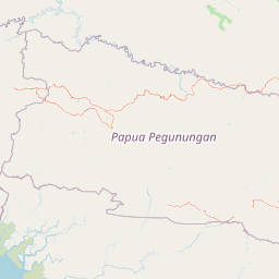
Map view of Lorentz National Park

Use this park location map to pinpoint Lorentz National Park in Indonesia, understand its exact geographic position, and read its mapped placement within the surrounding landscape more clearly.

Pigeon | © OpenStreetMap contributors

Location context for Lorentz National Park

Central PapuaHighland PapuaSouth Papua
Park atlas

Explore the surrounding landscapes and comparable protected areas in the broader New Guinea region and Southeast Asia, tracing geographic connections.

Discover Other Protected Areas and National Parks Near Lorentz National Park
Continue your geographic discovery beyond Lorentz National Park by exploring other significant protected areas and national parks within the wider Asia-Pacific region. Compare diverse landscapes, conservation profiles, and ecological gradients across regional geography to understand their unique protected status and conservation challenges.
National parkWest Papua

Teluk Cenderawasih National Park: West Papua's Protected Landscape and Geographic Atlas Entry

Mapped boundaries and regional natural geography.

Delve into the protected area details of Teluk Cenderawasih National Park, situated in the West Papua region. This page serves as a factual entry point for understanding the park's geographic placement and its role as a mapped natural landscape. Examine the park's protected boundaries and how they integrate with the regional geography, providing essential context for atlas exploration.

Area
14,535 km²
Established
2002
IUCN
II
Scope
Mixed
Stylized illustration of a mountain with waterfalls, river, and trees under a bright sky with clouds
Protected areaPapua New Guinea

Mount Wilhelm Protected Area: Papua New Guinea's Highest Peak and Alpine Terrain

Mapped geography and protected landscape context for a key Oceania peak.

Mount Wilhelm represents a significant protected area and the highest mountain in Papua New Guinea. Situated within the Bismarck Range, its dramatic granite peak defines a unique alpine environment, transitioning from dense rainforests to high-altitude grasslands. The presence of twin glacial lakes, Piunde and Aunde, adds to its distinctiveness, offering insight into the region's varied natural terrain and its role as a key geographical landmark.

Relief
Mountain
Climate
Alpine
Access
Moderate access
Scope
Terrestrial
National parkMaluku

Manusela National Park: National Park Atlas Exploration and Geographic Context

Mapped protected landscape in Maluku, Indonesia

Manusela National Park serves as a key entity for understanding protected land distribution and regional geography within Indonesia. As a designated national park, it provides a unique opportunity for detailed atlas exploration, focusing on its mapped boundaries and specific landscape character. Discover the geographic significance and conservation context of this protected area in Maluku.

Area
1,890 km²
Established
1997
IUCN
II
Relief
Mountain
National parkNorthern Territory

Garig Gunak Barlu National Park: Northern Territory's Remote Protected Coastal Wilderness & Map Atlas

Explore its unique marine protected area and mapped landscape context.

Garig Gunak Barlu National Park is a significant protected coastal wilderness, covering the entire Cobourg Peninsula in Australia's Northern Territory. This national park designation protects extensive terrestrial landscapes alongside vital adjacent marine waters. The park is renowned for its comprehensive safeguarding of marine turtle habitats and its designation as a Ramsar Wetland, emphasizing its ecological importance. Understanding Garig Gunak Barlu National Park involves exploring its mapped protected boundaries and its role as a crucial element of Northern Territory's protected landscapes, offering a unique atlas-style view of coastal conservation.

Area
2,260.06 km²
Established
2000
IUCN
II
Relief
Lowland
National parkQueensland

Saunders Islands National Park: National Park Geography and Mapped Protected Landscape in Queensland

Explore the mapped terrain and protected area context.

Saunders Islands National Park represents a significant protected area within the geography of Queensland, Australia. This entry provides detailed atlas-level insights into its specific geographic boundaries and the nature of its protected landscape. Users can understand the park's regional placement and its mapped natural terrain, offering a concrete point for exploring Queensland's diverse protected lands and their unique environmental characteristics.

Area
0.19 km²
Established
1989
IUCN
II
Climate
Tropical
National parkQueensland

Sir Charles Hardy Group National Park: Queensland National Park Atlas and Geography

Explore its mapped protected landscape and regional context.

Sir Charles Hardy Group National Park serves as a vital protected area within Queensland, Australia. This entry offers an atlas-centric view, detailing the park's mapped boundaries and its contribution to the regional geography. Examine its significance as a national park and understand the natural terrain it encompasses within northeastern Australia.

Area
1.29 km²
Established
1989
IUCN
II
Scope
Terrestrial
National parkQueensland

Piper Islands National Park: Queensland National Park with Critical Seabird Colonies

Explore mapped boundaries and landscape context for this Great Barrier Reef island sanctuary.

Piper Islands National Park in Queensland is a protected area comprising four coral cays vital for significant seabird nesting populations. Recognized as an Important Bird Area, these islands showcase distinct mangrove and Pisonia forest ecosystems against the backdrop of the inner northern Great Barrier Reef. The park's protected landscape offers a unique glimpse into the ecological importance of these small, dynamic coastal landforms within a world-heritage marine setting.

Area
0.07 km²
Established
1989
IUCN
II
Relief
Lowland
National parkQueensland

Wuthara Island National Park: Protected Island Geography in Queensland's Coral Sea

Explore mapped coastal landscape and protected area context.

Wuthara Island National Park is a significant protected area located in the Coral Sea, contributing to Queensland's network of national parks. Its island geography and position within the Great Barrier Reef Marine Park region offer a unique perspective on coastal landscape conservation. This page provides detailed information to help users understand the park's role as a protected national park and its specific contribution to the mapped geography of tropical Australia.

Area
1.09 km²
Established
1990
IUCN
II
Relief
Lowland

Common questions about visiting, size, designation, and location context for Lorentz National Park

Lorentz National Park FAQs for park facts, access, geography, and protected area context
Find quick answers about Lorentz National Park, including protected-area facts, park geography, trail and visitor context, and how the park fits into its surrounding country and regional landscape.
MoriAtlas Explorer

Continue Your Protected Areas Search Across the Global Atlas

Deepen your exploration by continuing the structured search for national parks and protected areas worldwide. Utilize the comprehensive filtering capabilities to compare different conservation landscapes and refine your understanding of global park geography. Discover more about the distribution and characteristics of protected natural areas.

Global natural geography
