Mori Atlas logo
Wildlife reserveBao Bolong Wetland Reserve

Discover mapped boundaries and crucial habitat within this extensive West African coastal wetland.

Bao Bolong Wetland Reserve: Gambia's Premier Protected Wetland Landscape and Wildlife Reserve

(Baobolon Wetland Reserve)

Bao Bolong Wetland Reserve in Gambia represents a significant protected area, celebrated for its vital role in West African wetland conservation. This wildlife reserve encompasses approximately 220 square kilometers of diverse habitats, including some of the tallest mangroves in the Senegambia region, salt marshes, and savanna, all situated along the estuary of the Bao Bolong tributary. Its geographic prominence is underscored by its designation as a Ramsar wetland and an Important Bird Area, highlighting its importance for species like the endangered West African manatee and a rich avian population of 268 recorded species.

Wetland ReserveRamsar SiteBirdwatchingMangrove ForestWest AfricaProtected Area

Bao Bolong Wetland Reserve

Wildlife reserve

Park overview

Structured park overview, official facts, and landscape profile for Bao Bolong Wetland Reserve

Bao Bolong Wetland Reserve park facts, protected area profile, and essential visitor context
Review the core facts for Bao Bolong Wetland Reserve, including designation, size, terrain, visitor scale, habitats, and operating context in one park-focused overview.

About Bao Bolong Wetland Reserve

Bao Bolong Wetland Reserve represents one of the most ecologically significant protected areas in The Gambia and serves as a vital wetland ecosystem along the West African coast. The reserve is positioned on the north bank of the River Gambia, approximately 100 kilometres upstream from where the river empties into the Atlantic Ocean. Its central feature is the estuary of the Bao Bolong tributary, a waterway that originates in Senegal before joining the Gambian river system. The protected area stretches across roughly 220 square kilometres, forming a linear reserve about 22 kilometres long and nine kilometres wide. The geography is characterized by extremely flat terrain, with the highest point reaching just 12 metres above sea level, creating the typical low-lying wetland landscape that defines this region of the Gambia. The reserve encompasses multiple tributary channels and supports a complex mosaic of wetland habitats. A distinguishing feature of Bao Bolong is the dense mangrove forest that borders the river, stretching approximately 2.5 kilometres in width. This mangrove ecosystem is unique in the Senegambia region, supporting tree growth to heights not found elsewhere in the area. The reserve lies directly opposite Kiang West National Park on the southern bank of the River Gambia, creating a complementary protected landscape along this important waterway. Twenty-five small towns are situated around the reserve's perimeter, with local communities engaged in fishing, livestock grazing, and collection of timber and firewood within the protected area.

Quick facts and research context for Bao Bolong Wetland Reserve

Bao Bolong Wetland Reserve is situated on the north bank of the River Gambia, approximately 100 kilometres from the river mouth into the Atlantic Ocean. The protected area spans roughly 220 square kilometres along a 22-kilometre length with an approximate width of nine kilometres. Established in 1996 as a Ramsar wetland, it was the first reserve in the Gambia to receive international wetland protection under the Ramsar Convention. The landscape is notably flat, with elevations not exceeding 12 metres above sea level. The reserve encompasses the Bao Bolong river estuary along with several tributary waterways including Salokini Bolong, Mandon Bolong, Duntu Malang Bolong, Tanku Bolong, and Katchang Bolong. A dense mangrove forest zone approximately 2.5 kilometres wide borders the river, while the southern boundary is formed by the River Gambia itself.

Park context

Deeper park guide and search-rich context for Bao Bolong Wetland Reserve

Bao Bolong Wetland Reserve history, landscape, wildlife, and travel context
Explore Bao Bolong Wetland Reserve through its history, landscape character, ecosystems, wildlife, conservation priorities, cultural context, and seasonal travel timing in a structured park guide built for atlas discovery and search intent.

Why Bao Bolong Wetland Reserve stands out

Bao Bolong Wetland Reserve is best known for its exceptional wetland ecosystem and remarkable bird diversity. The reserve hosts the tallest mangrove trees in the Senegambia region, with specimens reaching heights of 20 metres. It supports 268 bird species across 62 families, making it a prime destination for ornithologists and birdwatchers. The wetland provides critical habitat for significant waterbird populations including the pink-backed pelican, African darter, various herons, storks, and ibises. The reserve is also notable for its population of West African manateees, an endangered species that inhabits the waters between the mangroves. As Gambia's first Ramsar-designated wetland, it holds special significance in the national and international conservation context.

Bao Bolong Wetland Reserve history and protected-area timeline

Bao Bolong Wetland Reserve was first established on 1 January 1993 as Bao Bolong National Reserve, covering an initial area of 35 square kilometres. On 16 September 1996, the protected area was significantly expanded to approximately 220 square kilometres, transforming it into one of the largest wetland reserves in the Gambia. This expansion coincided with the site's designation as a Ramsar Wetland, making it the first area in the Gambia to receive protection under the Ramsar Convention on Wetlands. The Ramsar Convention, originally drafted under the auspices of UNESCO in 1971 and entering into force in 1975, provides international protection for significant wetland habitats, particularly those serving as homes for waterbirds and Charadriiformes. The designation of Bao Bolong as a Ramsar site marked a significant milestone in Gambian environmental conservation and established a framework for the protection of other wetland areas in the country, including the Tanbi Wetland Complex and Niumi National Park. There are ongoing plans to extend the protected area across the border into Senegal, with the intention of establishing joint management arrangements with Senegalese authorities to ensure comprehensive conservation of the transboundary wetland ecosystem.

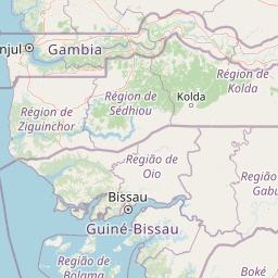
Bao Bolong Wetland Reserve landscape and geographic character

The landscape of Bao Bolong Wetland Reserve is defined by its low-lying coastal wetland character, with terrain so flat that the highest point reaches only 12 metres above sea level. The reserve is centred around the estuary of the Bao Bolong tributary, where this waterway meets the larger River Gambia. The protected area occupies a roughly linear configuration extending 22 kilometres in length with an approximate width of nine kilometres. The southern boundary is formed by the main channel of the River Gambia, while the northern edge is bordered by the north bank road, the second most important highway in the Gambia. A distinctive landscape feature is the dense mangrove forest that adjoins the river, stretching approximately 2.5 kilometres inland from the riverbank. This mangrove zone represents the most extensive and developed mangrove forest in the Senegambia region. Beyond the mangroves, the landscape transitions through salt marsh areas and into savanna terrain. The reserve incorporates several tributary waterways including Salokini Bolong, Mandon Bolong, Duntu Malang Bolong, Tanku Bolong, and Katchang Bolong, each contributing to the complex hydrological network that defines this wetland system.

Bao Bolong Wetland Reserve ecosystems, habitats, and plant life

The ecological character of Bao Bolong Wetland Reserve centres on its diverse wetland habitats, which support remarkable biodiversity across multiple ecosystem types. The mangrove forest represents the most significant habitat, with species including Rhizophora racemosa, red mangrove, and black mangrove reaching heights of 20 metres, the tallest in the Senegambia region. The salt marsh areas support succulent species such as Sesuvium portulacastrum and various grasses including Sporobolus spicatus, Paspalum vaginatum, and Diplachne fusca. Flooded savanna areas feature common species such as Phragmites karka, Echinochloa pyramidalis, and papyrus reed. The savanna zones support tree species including Daniellia oliveri, Terminalia albida, and Bombax costatum, alongside diverse shrubs and grasses. Important protected tree species identified in the Ramsar Information Sheet include Pterocarpus erinaceus, Parinari macrophylla, the ana tree, wild mango trees, and Néré. The wetland supports complex ecological interactions between terrestrial and aquatic systems, creating a rich mosaic of habitats that sustain diverse plant and animal communities.

Bao Bolong Wetland Reserve wildlife and species highlights

Bao Bolong Wetland Reserve supports exceptional wildlife diversity, particularly in avifauna, with 268 bird species from 62 families recorded within its boundaries. The reserve has been designated an Important Bird Area by BirdLife International, recognizing its global significance for bird conservation. Waterbirds form a particularly prominent group, featuring comb duck, spur-winged goose, white-faced whistling duck, garganey, northern pintail, African pygmy goose, and northern shoveler. The reserve provides crucial habitat for numerous heron species including western reef heron, little egret, squacco heron, little bittern, Goliath heron, great egret, grey heron, and cattle egret. Stork species present include woolly-necked stork, marabou stork, and yellow-billed stork. The pink-backed pelican and African darter also inhabit the reserve. Waders such as spur-winged lapwing, little stint, and common sandpiper thrive in the brackish water areas. The kingfisher family is well represented with woodland kingfisher, pied kingfisher, giant kingfisher, malachite kingfisher, and blue-breasted kingfisher. Mammal diversity includes 32 species with African clawless otter, various antelopes including sitatunga, bushbuck, and duiker, warthogs, spotted hyena, and leopards. Primate species include red colobus, patas monkey, green monkey, Guinea baboon, and Senegal bushbaby. The endangered West African manatee inhabits the mangrove waterways, while West African crocodiles are also present. Fish diversity includes species such as barracuda, tilapia, mullet, and various other marine and freshwater species.

Bao Bolong Wetland Reserve conservation status and protection priorities

Bao Bolong Wetland Reserve holds particular significance in the conservation landscape of The Gambia and the broader West African region. As the first Ramsar-designated wetland in the Gambia, established on 16 September 1996, it pioneered the recognition of wetland conservation needs within the national protected area system. The Ramsar Convention provides international protection for this habitat, specifically focusing on the preservation of waterbird habitats and Charadriiformes populations. The reserve's designation as an Important Bird Area by BirdLife International further underscores its global conservation importance. Protected tree species within the reserve include Pterocarpus erinaceus, Parinari macrophylla, Acacia albida, Cordyla africana, and Parkia biglobosa, all of which receive protection within the reserve boundaries. The presence of endangered species including the West African manatee adds to the conservation significance of the site. Climate change represents an emerging threat, with the reserve included in the IPCC Sixth Assessment Report's list of African natural heritage sites potentially threatened by flooding and coastal erosion. Plans for transboundary extension into Senegal, with joint management arrangements, reflect a forward-looking approach to conservation that addresses the ecological connectivity of the wider wetland system.

Bao Bolong Wetland Reserve cultural meaning and human context

Bao Bolong Wetland Reserve exists within a landscape shaped by human settlement and traditional land use practices. Twenty-five small towns are situated around the reserve's boundaries, with one located within the park limits proper. Local communities have traditionally conducted fishing in the waters of the reserve for personal consumption, while their livestock graze within the protected area. Residents also collect timber and firewood from the reserve, activities that reflect the sustainable use principles underlying the site's IUCN Category VI designation. The town of Salikenne, with a population of approximately 4,000, lies to the west of the reserve near the Dobo Forest Park. The communities of Nja Kunda, Minti Kunda, Kekuta Kunda, No Kunda, Konti Kunda Sukoto, Konti Kunda Nji, and Illiassa are situated along the north bank road that borders the reserve. The eastern section of the reserve can be accessed via a nine-kilometre fork from the main road leading to the town of Katchang. Farafenni, the largest city in the North Bank Division with a population exceeding 30,000, lies approximately 18 kilometres to the east of the reserve's outer limits.

Top sights and standout views in Bao Bolong Wetland Reserve

Bao Bolong Wetland Reserve stands out as a premier wetland conservation area in West Africa, combining Ramsar designation, Important Bird Area status, and exceptional biodiversity within a single protected landscape. The reserve features the tallest mangroves in the Senegambia region, with trees reaching 20 metres in height. Its bird population of 268 species across 62 families makes it a magnet for ornithologists and birdwatchers. The presence of the endangered West African manatee adds a mammalian highlight of significant conservation importance. The site's position on the north bank of the River Gambia, approximately 100 kilometres from the Atlantic coast, creates a strategic location for transboundary conservation extending into Senegal. The diversity of habitats ranging from mangrove forest through salt marsh to savanna creates a complex ecological tapestry. As the first Ramsar site in the Gambia, the reserve established a precedent for wetland protection that continues to influence conservation planning throughout the country.

Best time to visit Bao Bolong Wetland Reserve

The optimal time to visit Bao Bolong Wetland Reserve aligns with the dry season in The Gambia, typically running from November through April. During this period, wildlife becomes more concentrated around remaining water sources, making animal sightings more predictable. Birdwatching is particularly productive during the dry season when migratory waterbirds are present and vegetation is less dense, allowing for clearer observations. The cooler temperatures during these months make outdoor exploration more comfortable. The wet season from May to October brings heavier rainfall and higher humidity, which can affect access within the wetland areas. However, the wet season transforms the landscape with fresh vegetation and may offer different wildlife viewing opportunities. For birdwatching specifically, the period from November to March coincides with the arrival of European migratory species, expanding the already diverse avifauna. The extreme flatness of the terrain means that seasonal flooding patterns can significantly alter accessibility and the character of the landscape.

Park location guide

Geography guide, regional context, and park location map for Bao Bolong Wetland Reserve

Bao Bolong Wetland Reserve park geography, regions, and map view in Gambia
Understand where Bao Bolong Wetland Reserve sits in Gambia through a broader geographic reading of the surrounding landscape, nearby location context, and its mapped position within the national park landscape.

How Bao Bolong Wetland Reserve fits into Gambia

The Gambia is a small West African nation located along the Gambia River, which flows from east to west and empties into the Atlantic Ocean. It is the smallest country in continental Africa by area and is almost entirely surrounded by Senegal. The country gained independence from Britain in 1965 and operates as a unitary presidential republic with Banjul as its capital.

Wider geography shaping Bao Bolong Wetland Reserve in Gambia

The Gambia occupies a narrow strip of land along the Gambia River in West Africa. The country spans approximately 11,300 km² and is almost completely surrounded by Senegal, with only a short Atlantic coastline in the west. The terrain is generally flat with floodplains along the river.

Map view of Bao Bolong Wetland Reserve

Use this park location map to pinpoint Bao Bolong Wetland Reserve in Gambia, understand its exact geographic position, and read its mapped placement within the surrounding landscape more clearly.

Pigeon | © OpenStreetMap contributors

Location context for Bao Bolong Wetland Reserve

North Bank Division
Park atlas

Trace the wider protected landscapes and regional park geography around The Gambia's significant wetland ecosystems.

Discover Other Protected Areas Near Bao Bolong Wetland Reserve, The Gambia
Explore other vital protected areas and wetland reserves across The Gambia and surrounding West African regions, tracing their unique conservation landscapes and ecological diversity. After exploring the internationally recognized Bao Bolong Wetland Reserve, you can compare adjacent or thematically similar protected sites to understand broader regional conservation efforts and mapped park geography.
National parkGambia

Kiang West National Park: National Park Detail and Protected Landscape Geography

Explore mapped boundaries and regional context in The Gambia.

Kiang West National Park serves as a crucial point for understanding protected natural areas within The Gambia, West Africa. This national park's identity is rooted in its geographic setting along the Gambia River, offering a distinct landscape context and mapped territory. Users can explore its boundaries and place within the nation's conservation network, contributing to a structured understanding of regional geography and protected lands.

Area
115 km²
Established
1987
IUCN
II
Relief
Lowland
National parkGambia

Niumi National Park: Gambia's Extensive Mangrove Forest and Coastal Wetland Protected Area

Explore the mapped boundaries and unique delta geography of this important national park.

Niumi National Park, situated in The Gambia, is a crucial protected coastal area celebrated for its vast Rhizophora mangrove forests and diverse wetland ecosystems. As a designated national park and Ramsar site, it serves as a critical habitat for numerous migratory bird species, particularly terns, and supports vulnerable marine life. Its landscape is characterized by tidal channels, brackish lagoons, and intertidal mudflats, creating a dynamic and ecologically significant protected zone that is a focal point for understanding West African coastal geography and conservation.

Area
49.4 km²
Established
1987
IUCN
II
Relief
Lowland
National parkGambia

Tanbi Wetland Complex National Park: A Mapped Protected Area in The Gambia

Explore its protected boundaries and regional landscape.

Delve into the geographic identity of Tanbi Wetland Complex National Park, a designated protected area within The Gambia. This page provides essential atlas-level information, focusing on its mapped natural landscape and its role as a significant national park. Understand the park's protected status and its geographical context along the Gambia River, offering a clear entry point for conservation landscape discovery.

Area
45 km²
Established
2001
IUCN
II
Relief
Lowland
National parkSenegal

Saloum Delta National Park: Detailed Map Exploration of Senegal's Protected Landscape

Explore the mapped boundaries and regional terrain of this national park.

Saloum Delta National Park, a designated national park in Senegal, serves as a key entity for understanding protected landscapes in West Africa. This entry focuses on its geographic specificities, providing mapped context and details about its natural terrain. Users can explore the park's boundaries and regional landscape character, contributing to a richer atlas-based discovery of Senegal's conservation areas and natural geography.

Area
760 km²
Established
1976
Relief
Lowland
Climate
Tropical
Nature reserveGambia

Abuko Nature Reserve: A Protected Nature Reserve in Gambia's Landscape

Explore its mapped boundaries and geographic context.

Abuko Nature Reserve is a protected natural area situated in Gambia, offering a distinct focus for understanding protected landscapes. This entry provides essential details for atlas-based discovery, highlighting the reserve's mapped boundaries and its role within the regional geography. Examine Abuko Nature Reserve to gain clarity on its protected status and its contribution to the mapped natural terrain of West Africa.

Area
1.07 km²
Established
1968
IUCN
IV
Relief
Lowland
Watercolor illustration of a river flowing through a landscape with trees, grassy areas, and distant hills under a soft sky
National parkCentral River Division

River Gambia National Park: National Park Geography and Protected Landscape Atlas

Discover mapped boundaries within Central River Division.

River Gambia National Park represents a key protected area within the Central River Division, offering specific geographic insights for atlas exploration. This page details the park's mapped boundaries and its role as a national park, providing a factual basis for understanding its landscape context and regional importance. Explore the geographic features that define this protected natural area.

Area
5.85 km²
Established
1978
IUCN
II
Relief
Lowland
National parkGambia

Tanji Bird Reserve National Park: Coastal Wetlands and Avian Diversity in Gambia

Explore unique geography and protected landscape boundaries.

Tanji Bird Reserve National Park showcases a distinctive coastal landscape where the Atlantic Ocean meets lagoons, dry woodland, and dune scrub. This 612-hectare protected area in The Gambia is celebrated for its incredible birdlife, with nearly 300 species recorded, including significant Palearctic migrants and the nation's sole breeding seabird colonies on the Bijol Islands. The reserve offers a rich context for understanding West African protected areas, mapped terrain, and coastal ecosystem geography.

Area
6.12 km²
Established
1993
IUCN
II
Relief
Lowland
National parkZiguinchor Region

Basse Casamance National Park: National Park with Mapped Boundaries in Ziguinchor Region

Detailed protected landscape and regional geography context.

Basse Casamance National Park serves as a critical protected area, offering users a clear view of its national park designation and its specific geographic location within Senegal. This entity is vital for understanding conservation landscapes and mapped terrain in the Ziguinchor Region. The platform provides structured data on its protected boundaries, allowing for focused atlas exploration and a deeper appreciation of its regional geographic significance without leaving the core park identity.

Area
50 km²
Established
1970
IUCN
II
Climate
Tropical

Common questions about visiting, size, designation, and location context for Bao Bolong Wetland Reserve

Bao Bolong Wetland Reserve FAQs for park facts, access, geography, and protected area context
Find quick answers about Bao Bolong Wetland Reserve, including protected-area facts, park geography, trail and visitor context, and how the park fits into its surrounding country and regional landscape.
MoriAtlas Explorer

Continue Your Protected Areas Search Across the Global Atlas

Deepen your exploration by continuing the structured search for national parks and protected areas worldwide. Utilize the comprehensive filtering capabilities to compare different conservation landscapes and refine your understanding of global park geography. Discover more about the distribution and characteristics of protected natural areas.

Global natural geography