Mori Atlas logo
Protected areaNimba National Forest

Discover its mapped boundaries, avian significance, and regional geography at the tri-border area.

Nimba National Forest: Protected Mountain Landscape in Nimba County, Liberia

Nimba National Forest represents a vital protected area situated in Nimba County, Liberia, forming a key ecological component of the Upper Guinea forest zone. This mountainous sanctuary spans approximately 187 square kilometers across its eastern and western sections, encompassing the rugged slopes and terrain of the Nimba Range. As an Important Bird Area, it offers critical habitat for numerous bird species and contributes to the broader conservation landscape at the confluence of Liberia, Guinea, and Ivory Coast.

National ForestProtected AreaImportant Bird AreaMountain ForestWest AfricaNimba Range

Nimba National Forest

Protected area

Park overview

Structured park overview, official facts, and landscape profile for Nimba National Forest

Nimba National Forest park facts, protected area profile, and essential visitor context
Review the core facts for Nimba National Forest, including designation, size, terrain, visitor scale, habitats, and operating context in one park-focused overview.

About Nimba National Forest

Nimba National Forest represents a significant protected forest area in northern Liberia, positioned in the mountainous Nimba Range near the country's border with Guinea and Ivory Coast. The forest covers approximately 187 square kilometers divided between eastern and western sections, encompassing slopes and terrain that form part of a broader mountain system extending across the tri-border region of West Africa. The protected area was established to conserve the forest ecosystems and the biological diversity found within this mountainous landscape. The forest's location at the intersection of three countries gives it regional ecological importance, as it forms part of a contiguous ecological zone that transcends national boundaries. The Nimba Range itself is a notable topographic feature in West Africa, and the forest protection helps preserve watershed functions and habitat connectivity in this portion of the Upper Guinea forest zone. The area has been the focus of conservation interventions aimed at balancing environmental protection with sustainable community use of natural resources.

Quick facts and research context for Nimba National Forest

Nimba National Forest is situated in Nimba County, northern Liberia, occupying a mountainous area near the borders with Guinea and Ivory Coast. The forest is divided into eastern and western sections covering 96 km² and 91 km² respectively. The area is part of the larger Nimba Range, a mountainous region in West Africa. The forest has been designated an Important Bird Area by BirdLife International due to its significant bird populations. Conservation partnerships involving Conservation International Liberia and ArcelorMittal have been established to support biodiversity protection and community-based natural resource management in the region.

Park context

Deeper park guide and search-rich context for Nimba National Forest

Nimba National Forest history, landscape, wildlife, and travel context
Explore Nimba National Forest through its history, landscape character, ecosystems, wildlife, conservation priorities, cultural context, and seasonal travel timing in a structured park guide built for atlas discovery and search intent.

Why Nimba National Forest stands out

Nimba National Forest is best known for its designation as an Important Bird Area by BirdLife International, recognizing its significant populations of bird species. The forest is also recognized for its historical populations of western chimpanzees in the Nimba Range area. The mountain landscape and its position at the tri-border region of Liberia, Guinea, and Ivory Coast give it regional ecological significance. Conservation agreements linked to biodiversity protection and community livelihoods have been established through partnerships involving Conservation International Liberia and the mining company ArcelorMittal.

Nimba National Forest history and protected-area timeline

Nimba National Forest has existed as a designated protected area, though detailed historical information about its establishment and early management is limited in available sources. The forest reserves were affected significantly by Liberia's civil conflicts, particularly the First and Second Liberian Civil Wars that occurred between 1987 and 2003. During this period, the forest areas experienced pressures from factional fighting, resource extraction activities, and displacement of local populations into forested areas. Notably, local communities reported that chimpanzee populations in some forest reserve areas actually increased during the conflict period, possibly due to reduced human activity in remote areas. However, subsequent periods saw significant impacts from post-conflict pressures including renewed resource extraction and settlement expansion. Conservation partnerships have been developed in more recent years, with agreements involving Conservation International Liberia and corporate partners to support biodiversity protection while addressing community livelihood needs.

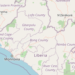
Nimba National Forest landscape and geographic character

Nimba National Forest is situated within the Nimba Range, a mountainous region in northern Liberia that forms part of the larger West African highland system. The forest encompasses the forested slopes of Mount Nimba and surrounding terrain, with terrain that includes steep slopes, ridges, and valley systems that drain into broader river networks. The landscape is characterized by forest-covered mountainous terrain that transitions from lower elevation forest zones to higher elevation habitats. The forest's position at the tri-border intersection of Liberia, Guinea, and Ivory Coast means it forms part of a contiguous landscape that extends across international boundaries. The eastern and western sections of the forest cover different portions of this mountainous terrain, with the two sections together comprising the protected forest area.

Nimba National Forest ecosystems, habitats, and plant life

Nimba National Forest is recognized as an Important Bird Area by BirdLife International, signifying that the forest supports significant populations of bird species warranting conservation attention. The forest is situated within the broader Nimba Range area, which represents an important ecological zone within the Upper Guinea forest region of West Africa. The forest ecosystems include various habitat types associated with the mountainous terrain, from lower elevation forest zones to higher elevation vegetation communities. The biodiversity significance of the area extends beyond birds to include other taxonomic groups, with the forest historically having supported populations of western chimpanzees. The conservation agreements established in the Nimba Range area have been designed to link biodiversity protection with community livelihoods, recognizing that sustainable conservation requires addressing the needs of local communities who depend on natural resources in and around the protected area.

Nimba National Forest wildlife and species highlights

Nimba National Forest is notable for its bird populations, having been designated an Important Bird Area because it supports significant populations of many bird species. The forest was historically thought to have supported populations of western chimpanzees before and during Liberia's civil conflict period, and local people reported that chimpanzee populations increased in certain forest reserve areas during the war years when human activity was reduced. However, post-conflict periods have seen increased pressures on wildlife from resource extraction and human settlement. The mountainous forest environment provides diverse habitats that support various wildlife species, though detailed species inventories and current population status information is limited in available sources. The broader Nimba Range area is recognized as an important region for biodiversity in West Africa, with the forest protection helping to preserve habitat for both bird and mammal species.

Nimba National Forest conservation status and protection priorities

Nimba National Forest has been recognized as an Important Bird Area by Bird Life International, a designation that highlights its significance for bird conservation at an international level. Conservation agreements in the Nimba Range area have involved partnerships between Conservation International Liberia, the corporate sector through ArcelorMittal, and local communities. These agreements are designed to link biodiversity protection with community livelihood improvement, recognizing that effective conservation requires addressing the socioeconomic needs of local populations. The forest has experienced significant conservation challenges from Liberia's civil conflicts and associated pressures including resource extraction and human displacement. Conservation efforts continue to focus on protecting the forest's biodiversity value while developing sustainable community-based approaches to natural resource management in the broader Nimba Range landscape.

Top sights and standout views in Nimba National Forest

Nimba National Forest stands as a protected mountain forest at the tri-border region of Liberia, Guinea, and Ivory Coast, representing an important ecological node in West Africa's Upper Guinea forest zone. The forest's designation as an Important Bird Area by BirdLife International highlights its international conservation significance for bird species. Conservation partnerships involving Conservation International Liberia and ArcelorMittal have established agreements linking biodiversity protection with community livelihoods in the Nimba Range area. The forest encompasses approximately 187 km² of mountainous terrain divided into eastern and western sections, providing habitat connectivity and watershed protection functions in this border region.

Park location guide

Geography guide, regional context, and park location map for Nimba National Forest

Nimba National Forest park geography, regions, and map view in Liberia
Understand where Nimba National Forest sits in Liberia through a broader geographic reading of the surrounding landscape, nearby location context, and its mapped position within the national park landscape.

How Nimba National Forest fits into Liberia

Liberia is a West African country on the Atlantic coast, bordered by Sierra Leone, Guinea, and Ivory Coast. Founded as an American Colonization Society settlement in 1822, it became Africa's first independent republic in 1847. The country has a population of approximately 5.4 million and uses both the US dollar and Liberian dollar as currency.

Wider geography shaping Nimba National Forest in Liberia

Liberia occupies the West African Atlantic coast, stretching from Sierra Leone in the northwest to Ivory Coast in the east. The country features a coastal plain that rises to a rolling plateau and mountainous regions in the northeast. Several rivers, including the Mano and St. John rivers, flow across the territory. The climate is tropical with distinct wet and dry seasons.

Map view of Nimba National Forest

Use this park location map to pinpoint Nimba National Forest in Liberia, understand its exact geographic position, and read its mapped placement within the surrounding landscape more clearly.

Pigeon | © OpenStreetMap contributors

Location context for Nimba National Forest

Nimba County
Park atlas

Explore West African Protected Landscapes and Regional Park Geography Beyond Nimba National Forest's Borders

Discover Other National Parks and Protected Areas Near Nimba National Forest
Continue your exploration from Nimba National Forest to browse other significant national parks and protected areas across Liberia and the broader tri-border region of West Africa. Compare mountain forests, Important Bird Areas, and diverse conservation landscapes, gaining deeper geographic context and understanding the regional spread of protected zones.
National parkNimba County

Gio National Forest National Park: A Protected Landscape in Nimba County

Mapping the geographic boundaries and regional context of Gio National Forest.

Gio National Forest National Park serves as a key protected area within Liberia's Nimba County. This destination facilitates detailed exploration of its specific geographic footprint and its contribution to the regional atlas. Users can investigate the park's natural landscape context, mapped terrain, and its role as a protected conservation zone. Understand where this significant natural area fits within the broader geographic framework of West Africa.

Area
327 km²
Established
1960
IUCN
IV
Relief
Upland
Protected areaNimba County

Gibi National Forest: Protected Tropical Forest in Nimba County, Liberia

Mapped landscape and regional geography of this key conservation area.

Gibi National Forest, a protected tropical forest spanning 607 square kilometers in Nimba County, Liberia, plays a crucial role in the preservation of the Upper Guinea forest ecosystem. Established in 1960, its landscape features tropical forest terrain near the mountainous Nimba Range. This protected area contributes significantly to regional conservation strategies, offering a vital habitat within a biodiversity hotspot that faces considerable pressure.

Area
607 km²
Established
1960
IUCN
VI
Climate
Tropical
National parkIvory Coast

Mont Péko National Park: Ivory Coast National Park with Mapped Boundaries

Explore its protected landscape and regional geography.

Delve into Mont Péko National Park, a designated national park within Ivory Coast, to understand its unique protected landscape. This entry facilitates detailed atlas exploration, focusing on its geographic placement, mapped boundaries, and contribution to the regional natural terrain. Discover the essence of this protected area through its mapped geography and landscape identity.

Area
340 km²
Established
1968
IUCN
II
Relief
Mountain
Protected areaGbarpolu County

Kpelle National Forest: Protected Area Identity and Geographic Exploration

Explore Gbarpolu County's protected landscape.

Kpelle National Forest is a key protected area offering a unique glimpse into Liberia's natural geography. This atlas-driven exploration focuses on understanding its specific boundaries, regional placement within Gbarpolu County, and the broader landscape context. Discover the protected area's identity and its significance for geographic comprehension, enabling detailed map-based exploration and regional comparison.

Area
1,748 km²
Established
1961
Relief
Mountain
Climate
Tropical
National parkSinoe County

Sapo National Park: Explore Its Protected Landscape and Geographic Identity in Sinoe County

Discover mapped park boundaries and regional context.

Delve into the protected landscape of Sapo National Park, a key national park located in Sinoe County, Liberia. This page provides essential context for understanding its geographic setting, mapped park boundaries, and its significance as a protected natural area. It serves as a foundational entry for exploring Liberia's protected lands within the broader atlas, focusing on landscape identity and regional geographic features.

Area
1,804 km²
Established
1983
IUCN
II
Relief
Mixed relief
National parkIvory Coast

Taï National Park: A Primary Rainforest Protected Area in Ivory Coast

Explore mapped boundaries and critical primate habitats in West Africa.

Taï National Park in Ivory Coast stands as a monumental protected landscape, comprising the largest contiguous area of primary rainforest remaining in West Africa. Its designation as a national park highlights its critical role in preserving biodiversity and unique geographic features. Users exploring this destination can delve into its mapped terrain, understand its regional landscape context within Ivory Coast, and appreciate its significance as a vital habitat for endangered species and an integral part of the Upper Guinean forest ecosystem.

Area
3,300 km²
Established
1972
IUCN
II
Relief
Upland
National parkEastern Province

Gola Rainforest National Park: Sierra Leone's Premier Rainforest Protected Area

Explore mapped boundaries and biodiversity in Eastern Province's vast tropical rainforest.

Gola Rainforest National Park is Sierra Leone's second national park and the largest intact rainforest landscape in the country, located in the Eastern Province. As part of the Upper Guinea Forest biodiversity hotspot, it is renowned for its exceptional wildlife, including western chimpanzees and pygmy hippopotamuses. This protected area's mapped extent covers over 71,000 hectares, contributing significantly to regional conservation and providing a vital natural resource for both wildlife and local communities.

Area
710.7 km²
Established
2010
IUCN
II
Relief
Lowland
National parkSassandra-Marahoué District

Marahoué National Park: Protected Landscape and Geographic Setting in Ivory Coast

Mapped protected area boundaries and regional context.

Marahoué National Park represents a significant protected landscape within the Sassandra-Marahoué District, offering detailed geographic insights for atlas exploration. This entry focuses on the park's mapped boundaries and its identity as a national park, providing essential context for understanding its place in Ivory Coast's protected areas network. Discover the mapped terrain and regional landscape elements relevant to this protected natural site.

Area
1,000 km²
Established
1968
IUCN
II
Relief
Upland

Common questions about visiting, size, designation, and location context for Nimba National Forest

Nimba National Forest FAQs for park facts, access, geography, and protected area context
Find quick answers about Nimba National Forest, including protected-area facts, park geography, trail and visitor context, and how the park fits into its surrounding country and regional landscape.
MoriAtlas Explorer

Continue Your Protected Areas Search Across the Global Atlas

Deepen your exploration by continuing the structured search for national parks and protected areas worldwide. Utilize the comprehensive filtering capabilities to compare different conservation landscapes and refine your understanding of global park geography. Discover more about the distribution and characteristics of protected natural areas.

Global natural geography